
Severe Thunderstorm Risk Tonight
A severe thunderstorm watch has been issued for the central High Plains that will have implications farther east.
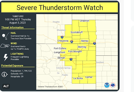 Note that wind gusts to 75 mph are forecast to occur along with 2 inch diameter hail.
 There will be a threat of winds of 60 mph or stronger at the storms move east. They should reach U.S. 81/I-135 by around 4am. From there, it should weaken a bit and then turn southeast as the storms cross the Flint Hills.

The watch ends at 10pm Central time. I mention that because the storms will concentrate and move into the central Great Plains.

Just a FYI: there is another chance of major severe thunderstorms in the Great Plains on Saturday.


Comments
Post a Comment