Posts

Showing posts from April, 2016

And, They'll Probably Send Astronauts to the Sun at Night

Image

An Air Traffic Controller's Nightmare

Image
Tuesday evening, 26th, the night when more tornadoes were forecast than actually occurred, was an air traffic controller's nightmare. This, via Twitter, is a snapshot of the flights headed to and out of Los Angeles International Airport. All of them are having to go around the complex of thunderstorms in the Great Plains. The few flights in the middle are going to other airports in the region.

Oklahoma Supercell

Image
There is a tremendous supercell south of Chickasha, Oklahoma, that has been trying to generate a large tornado with only partial success. It has just crossed U.S. 81. The storm is moving ENE. Tornado watch continues for the region.

Third Tornado Watch

Image
A third tornado watch for Oklahoma and the area around Wichita Falls, Texas. Also, until 10pm.

Tornado Watch: Ark-La-Tex

Image
This watch is in effect until 10pm.

Tornado Watch: Metroplex and North Texas

Image
Tornado watch now in effect until 10pm.

Update to Tornado Risk

Image
Here is the updated tornado risk. It has been moved south and west. The DFW Metroplex is now in the 10% area. Please keep in mind that 5% is the significant threshold. This could be another afternoon and evening of very large hail. Here 15% is significant and the hatching is areas where the hailstones could be larger than 2 inches. I'll update a time or two this afternoon and evening.

Tornado Threat Today

Image
The brown, 5%, is the significant threshold. If you live in these areas, please keep up on the weather today and tonight.

Others Are Realizing "The Single Most Important Question"!

People who read this blog have seen me write about this question over and over and over: What is the ideal earth temperature for the human race? Without an answer to that question, all of the climate debate is utterly irrelevant. As readers know, I have posed this questions, numerous times, to various climate scientists. I even sent it to a climate publication. No one wants to answer. Unless we know what the idea temperature is, we wouldn't know -- assuming it were possible -- how we calibrate any adjustable effect by humans on climate. Others are emphasizing this issue : Imagine something that is entirely possible—that a single such technological breakthrough enables us to control the world’s average temperatures. Could we then agree on what the ideal temperature should be? Is the current global average temperature the ideal one? Many would take that for granted, and climate alarmists appear to presuppose it, but the proposition is hardly self-evident. "Hardly

What I Had Planned to Say at Last Night's Andover Ceremony

This is the script I had prepared for the (cancelled due to weather) ceremony to commemorate the 25th anniversary of the Wichita-Andover Tornado last night. I thought some who were planning to attend might want to read it. The (S) is where the slides changed.  When I kissed my wife and children goodbye and left the house for work 25 years ago today, I had a terrible pain in the pit of my stomach. After reviewing the data, I knew there were going to be violent tornadoes in southern Kansas. My hope was they would occur in unpopulated rural areas.    But, that was not to be.     So, my next hope was that the early tornado forecasts – that local meteorologists started broadcasting three days before – and the warnings to be issued later in the day ahead of the tornadoes would save lives. (S) Considering the state of the art of tornado forecasting in 1991, the forecasts that Friday were amazingly good. (S) The morning tornado outlook, seen on the “Today” show’s and “Good

Five Years Later: Tornado Grief in the South

Image
Five years ago today, one of the five worst tornado events in U.S. history occurred with a swarm of tornadoes primarily in the South. There was a round of tornadoes and damaging winds in the morning that knocked out power to hundreds of thousands which prevented people from getting the warnings during the even worse round of tornadoes in the afternoon and evening. James Spann, based in Birmingham, is one of the finest television meteorologists in the United States. It is difficult for people outside of the regions of the nation visited by tornadoes to understand the horror of these storms. Two hundred fifty-two died in Alabama alone. To help understand, I highly recommend  this article .

Pause in Blogging

I have some things I have to do this morning. Please check back this afternoon. Much more to write about.

Last Update of the Night

Image
Radar from 9:25pm. I continue to be concerned about flooding during the night from Wichita to KC along the counties containing I-35 and one county on either side. Turn around, don't drown! This is the final update of the night.

Great Plains Weather Update

Image
As of 8:20pm, WD = wind damage. Within the last 20 minutes there were gusts of 70 mph around Chickasha, Oklahoma. The isolated cells ahead of the line might cause tornadoes. There is also a chance of a brief tornado in the lines with damaging winds. In Kansas, the primary threat is flash flooding.

Flash Flood Warning Wichita Area

Image
Here is the radar at 7:30pm. The storms are moving NNE bringing more heavy rain to the Wichita area. The dual polarization radar shows as much as five inches of rain have already fallen. The #1 cause of deaths in flash flooding is driving into flooded areas. Turn around, don't drown!

Update: Southern Kansas & Northern Oklahoma

Image
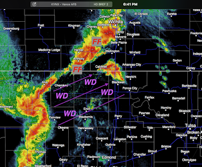
Wind damage (WD) ahead of a rapidly developing "blow echo" in northern Oklahoma that will move into southern Kansas. They sometimes produce brief tornadoes. FF = flash flood threat. A flash flood warning was just issued for Harper Co., Kansas. The flash flood threat will continue during the evening.  Update at 6:59pm. Radar at 6:56pm shows gusts above  70 mph in the circled area. Be aware with the approaching line of storms!

Forecast Update

Image
Here is the AccuWeather Regional Radar from 6:25pm. The tornado watches (scroll down) continue in effect. However, I've created this quick look at what I believe are the primary  hazards in each region  (not the exact location of the letters). FF = flash flood. Some spots in Kansas have already had 4" with more on the way. Tor = tornado  DW = damaging winds The satellite image from 6:15 has the 6pm dew points (a measure of humidity) plotted. The southeast winds are bringing more and more moisture into the region which could mean more rains that could cause rainfall in the inches as the evening progresses. Stay tuned!!

I've Done This Before

Image
April 26, 1991, Sumner Co. Kansas., tornado photo by Tim Marshall. April 26, 2016, Sumner Co. Kansas, photo via Twitter: I was tracking tornadoes in similar areas at this time 25 years ago. Here is the radar at 4pm. I've circled the rotation that is right over the town of Mayfield, Kansas. Confirmed tornado there.  It is moving NNE to NE. Red polygon is the tornado warning. At 4:02, I've circled the rotation on Doppler rotation, a luxury we did not have 25 years ago.

First Tornado WARNING of the Day

Image
3:17pm radar. Tornado warning in red polygon. Area of possible tornado circled. 1.5" hail already reported. Storm moving toward Wichita Metro. Follow me at twitter: @usweatherexpert.

Blog Update

I no longer "live blog" storms. The real-time data is sent via Twitter:   @usweatherexpert .

Particularly Dangerous Situation Tornado Watch: Oklahoma and Texas

Image
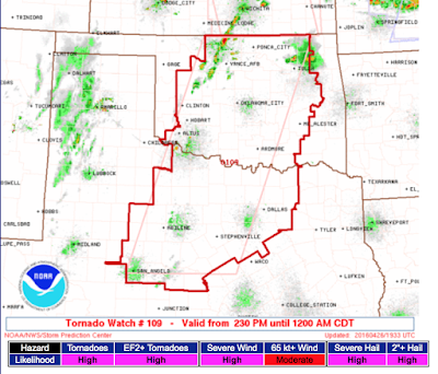
These watches are rare. Likelihood of violent tornadoes is "high." Please pay attention to the weather. Radar at 2:35pm shows no serious thunderstorms in the watch area at this time. The severe thunderstorm near Wakita will cross into Kansas shortly.

Tornado Watch: Kansas & S. Nebraska Until 9pm

Image
Here we go. I expect an Oklahoma watch shortly. In the meantime, red area is tornado watch for most of eastern half of Kansas and south central and SE Nebraska. Here is the radar at 2:12pm, lightning plotted. Storms, for now, are moving NNE as they develop.

The Andover Commemoration is CANCELLED

Image
After all of the work, I am extremely disappointed to report that the Andover Tornado Commemoration that so many have worked so hard on has been cancelled.  The concern is that we would be sending a mixed message to have a program about tornado safety during a (possible) tornado watch. McConnell AFB had to pull all of its participants out of the program because, as good stewards of our tax dollars, they are flying all of their planes to North Dakota and Washington.  When things calm down, I will probably post my script for this evening's event in case anyone would like to see it.  Sorry to disappoint everyone, but safety first. 

Updated Forecast Until 8pm

Image
Allow me to begin by saying that we residents of the Great Plains are hardy stock. We have been through tornado and other weather watches and warnings a million times. Perhaps because this is the 25th anniversary of the F-5 Andover tornado, people are a bit spooked and that is understandable.  Still, pay attention to the watches and warnings. Follow the safety rules posted below and we'll be fine.  There is one other concern that I only briefly mentioned and that is flash flooding. Some of the storms, especially in Kansas, are going to cause torrential rains. Please keep that in mind and see below. Storm Prediction Center Tornado Forecast Here their tornado forecast for this afternoon into tonight. The significant threshold is 5% and hatching means strong tornadoes are possible. While I don't disagree with the forecast, I can try to sharpen it a bit (I hope). Here is the weather satellite for 12:10pm and I've added some of the weather features. From now until

Seven Day Heavy Rain Outlook

Image
While everyone in the central and southern Great Plains is thinking about tornadoes and severe thunderstorms, there is another threat we need to be aware of: There is a possibility we could see a flooding pattern begin as early as this weekend in the South. Please stay tuned.

The Annual April Storm Chaser Story in Kansas

Image
I should just link to this story every April rather than writing a new one. See here , here , or here , among others. Below is a screen capture from KSNW-TV's (Wichita) version earlier this evening. The Kansas Highway Patrol evidently doesn't like storm chasers. I'm certain officer Crittenden thinks he is doing a service by going on the air to complain about storm chasers. He said that some chasers speed, some shoot video while driving and, according to the narrator, there was an instance where a chaser did not pull over in front of a police vehicle that had its red lights and siren on. I have a suggestion for officer Crittenden: Give them tickets!  Stop going on the air and griping about storm chasers! As KSNW's on meteorologist, Leon Smitherman pointed out, they depend on reports from storm chasers to help warn their viewers!   Think that is an isolated instance? Here is a screen shot from the NWS in Dodge City showing their work station during a tornado situa

A Quarter Century After the Andover Tornado

I had planned to post this tomorrow but, because of the potential for tornadoes tomorrow, I wanted to go ahead and post it this evening. On the set with me are, from left, John Holt, Melissa Beck and Steve Dennis. I had rushed onto the set speaking quickly (there were three major tornadoes going on simultaneously in our viewing area and the floor manager was giving me the "wrap it up!" signal). It was at that moment that I warned Andover for the first time, 19 minutes before the tornado reached the center of the city. The tornado killed 18. According to the Centers for Disease Control, 94 would have been killed if, as would have likely been the case if a similar storm had occurred 40 years earlier, there had been no warning. The main point of this posting is that you saw me in front of the camera as President of WeatherData, Inc. and the chief meteorologist of KSNW-TV. But, it was hardly just me. There was a superb team of meteorologists that I was proud to be part of

Andover Tornado 25th Anniversary Commemoration Update

It is a bit of a bitter coincidence that the 25th anniversary of the Andover tornado is going to be on a day with a serious tornado threat for much the same geographic area as in 1991. So, let's catch everyone up. Here is the one-hour special program on the iHeartRadio Wichita stations about the tornado that aired yesterday. My interview is toward the beginning of the program. By the way, I learned for the first time this morning the official death toll was 18, not 17. An infant who died did not originally make it onto the death list. Tomorrow evening is the official commemoration ceremony for the tornado is tomorrow evening. The details are at the link below: Remembrance, Recovery & Resilience: A Commemoration We did a complete rehearsal this morning and you will find it to be a moving and uplifting program. Now, the bad news: If a Particularly Dangerous Situation   Tornado Watch  (rare) is issued before 3pm, we are going to call the program off and it will not be

Tuesday Severe Weather Outbreak Forecast

Image
Here is the NWS Storm Prediction Center's forecast for 7am CDT Tuesday morning to 7am CDT Wednesday morning: Consider that, on a next-day outlook, 15% (yellow) is the significant threshold, it is easy to understand that this forecast is a big deal. There could be a number of violent tornadoes -- that may extend into the nighttime hours -- tomorrow afternoon and night. There could also be giant hail and damaging thunderstorm wind gusts. So, at the risk of repetition, let me remind everyone of the steps they should take to prepare themselves: In addition to these excellent suggestions, I have a few more: Make sure you have some extra money in your wallet. ATMs and credit cards are useless in a widespread power outage. You need to be planning now  for your children, elderly relatives and the infirm as to what to do if a tornado warning is issued. If you have a unique situation (a relative that can't go down the basement stairs to shelter), go pick them up when the watc

Where Tornado Warnings Come From

Image
Meteorologists will, again, be incredibly busy tomorrow issuing tornado watches, warnings and other types of products designed to keep Americans safe from approaching storms. Others will be issuing warnings to aircraft designed to keep them away from landing/taking off in dangerous weather and to avoid severe turbulence. Ever wonder how all this happens? The death toll from once-frequent downburst-caused plane crashes has been cut 100% since 2004. The death rate from tornadoes has been cut 97% since the 1930's. These are astonishing, Nobel-worthy accomplishments. Warnings  tells the story of how courageous meteorologists created the extremely effective, low-cost warning system we enjoy today. With storm season in full-force, now is a great time to read it or to give it as a Mother's Day or graduation gift. You can purchase a copy from Amazon here . From Barnes & Noble here . And, if you are coming to the 25th anniversary of the Andover tornado commemoration

Final Storm Report

Image
This is the last storm report of the evening. The tornado watch has been cancelled for all but northeast Kansas where it continues until 11pm. The main threat now is flash flooding. As much as 5" of rain has fallen with the line of storms that extends from near Topeka to south of Salina and more heavy rain is likely the next hour or two. This is the last update of the night.

8:20pm Severe Weather Update

Image
Tornado watch has been cancelled in Oklahoma and for some counties near Dodge City. No tornado warnings in effect at the moment. New severe thunderstorm warning just issued on the storms north of Wichita that were mentioned in the previous update (below).

7pm Update on Kansas Severe Weather Situation

Image
There is still a small chance of severe weather developing yet this evening. The dry line is holding in position (see satellite image and radar). The new clouds in what is now a very unstable airmass means there is still a small chance of redevelopment. So, the NWS, for now, is continuing the tornado watch and I agree.

5:05pm Tornado Watch Update

Image
I'd suggest people in Brockville and along I-70 in far western Saline Co. take shelter as there is the potential for a tornado to develop quickly. I've circled the rotation. Radar from 5:01pm. The storms to the south of the supercell are showing no signs of development at the present time and I do not expect development during the next 30 minutes. Note: For new readers, I tweet real-time information  @usweatherexpert.

First Tornado Warning of the Day

Image
The red polygon: We've also had reports of golf ball sized hail which will likely grow during the evening. Note that thunderstorms are now developing as far south as the KS-OK border. Those storms should begin moving ENE. REPORT OF A TORNADO 4:12pm.

Tornado Watch: Kansas & Oklahoma

Image
The NWS has issued a tornado watch for much of central and northeast Kansas and a part of north central Oklahoma until 11pm CDT. In addition to a risk of tornadoes, they are forecasting a "high" risk of hail ≥2" in diameter. My recommendations? See below for tornado suggestions. In addition, put the car in the garage to protect it from hail. Put trampolines and other items that can blow about indoors.  Time to make sure your children and infirm relatives are aware of the watch and have a plan for quickly getting them to shelter.  Note: While I no longer live-blog storms, I will update at least another couple of times through this evening. Below is the radar at 3:06pm. The storms in central Kansas are moving ENE.