Posts

Showing posts from May, 2022

Kansas and Oklahoma Hail Tracks

Image
This data is through 10pm. Large hail and/or flooding can ruin the winter wheat crop. These huge hailstones are the last thing farmers need.  Hail size is in millimeters, unfortunately. 100 milimeters = 4 inches.  Finally, to 10pm, here is the wheat belt rainfall for the past 48-hours. I'll have more on the rainfall tomorrow. 

Sunset View of Last Night's Storm

Image
The Kansas Sky. There is nothing else like it. 

Latest Winter Wheat Belt Palmer Drought Index

Image
Dry  --->  Wet This is the Palmer Drought Index as of May 25 for the winter wheat belt.  Below is a map of rainfall since the 25th.  Departure from normal rainfall since the 25th. The wheat harvest will begin this week or next in Texas and then move north. 

Global Warming Hypocrisy Continues in Full Force

Image
They discussed monitoring your every move (literally!) to insure you are living a low-carbon lifestyle. Them? Not so much. 

Note to Readers...

Forecast below still looks good. Dangerous  situation in Minnesota.  I will be storm chasing so will not be updating the blog. You can follow me on Twitter @usweatherexpert.

High Risk of Tornadoes This Afternoon and Tonight

Image
There are two areas of serious tornado risk.  Here is the breakdown of this forecast which is from the SPC (I agree with it): Red has a high  risk of tornadoes, some of which will be strong.  Yellow hatched has an enhanced risk of tornadoes, some of which will be strong. Yellow has an enhanced risk of tornadoes.  Brown has a significant risk of tornadoes.  Some tornadoes will occur after dark. Please call your friends and neighbors in these areas and let them know about this as it is a holiday and they may not be paying attention to the weather. 

On Memorial Day...

Image
Our Deepest Thanks to Those Who Gave Everything For Our Nation.  And, if we wish to stay a free country, I offer this thought from the great Ronald Reagan. 

Giant Hail Fell in Nebraska Sunday Evening

Image
In some areas, the hail was more than 5" in diameter. Below is a map of the areas with the largest hail. Note: I will have a complete update on the major tornado threat for Memorial Day (see below) around mid-morning Monday. 

Tornado Risk: Today and Memorial Day

Image
This Afternoon and Tonight There is an enhanced risk of tornadoes today in the yellow area and a significant risk in the brown area. It is important to monitor your local weather information in these areas later today. Memorial Day and Monday Night On my scale, there is a high  risk of tornadoes in the red area.There is an enhanced risk in the yellow area and, where there is hatching, the tornadoes could be strong.  In the brown area, there is a significant risk of tornadoes.  Even though it is a holiday, it will be important to follow the weather in these areas!

United Airlines Still Practices The Airline 'Weather' Lie

Image
From a story about the airline mess in the U.S. version of The Daily Mail : There was much less adverse weather yesterday than normal for the time of year. This is one of United's famous "airline lies." I covered this highly unfortunate aspect of United's culture here . It is one of the most-read pieces in the history of this blog.  The reason United does this is because, if it is 'weather,' they -- by regulation -- don'[t have to do anything for you. 

Sunday Fun: Global Warming, Is There Anything It Can't Do?!

Image
The nonsense article is here . Amazing how they can forecast sleep patterns eighty years from now. And..... Cooking human flesh?!  

Tornado Season Reminder

Image
This is Ben Holcomb's video of the April 29 tornado as it crossed Andover Road.  Below is a photo of one of the homes destroyed during the video. It is located on the left side of the road.  I wish to bring to your attention that, not only are windows broken out, there is a tree limb penetrating the home (arrow). While this home has a basement, it illustrates that if you do not have a basement or a professional storm shelter , it is vital to get into the bathtub or other small area like a closet in the middle of the house. The more walls between you and the outdoors, the better. 2011 Joplin Tornado aftermath The 2021 tornado season is not over!  A tornado caused damage in Virginia this morning and more tornadoes are likely next week.  Even though this is a holiday weekend, please keep an eye on the weather Sunday and Monday near and in the yellow and, especially, amber-colored areas. Tornadoes, hail and damaging winds are quite possible. Sunday Monday

Wise Words Regarding Mass Shootings

Image

3-Day Wheat Belt Rainfall

Image
Forecast rainfall for the next seven days:

Meteorological Mystery: Newly Discovered Information Pertaining to the Udall and Greensburg Tornadoes

Image
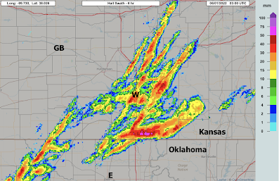
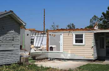
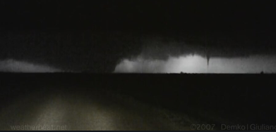
Bumped to the top on the 67th anniversary of the Blackwell-Udall Tornadoes. Please see note at the bottom.  May 4, 2007, looking north: The Greensburg Tornado is exiting the  city while the Trousdale Tornado touches down to the east. In my book, Warnings: The True Story of How Science Tamed the Weather ,  I discussed the unusual similarities between the 1955, F-5 intensity, Udall, Kansas, Tornado and the 2007, EF-5 intensity, Greensburg Tornado. The former tornado killed 82 and the latter 11. Among the similarities were the radar echoes, as shown in this figure from the book. The Udall Supercell was also responsible for the F-5 Blackwell, OK tornado that occurred an hour earlier killing 20.  Above is an illustration from Warnings.  It is a superimposure of the Tinker AFB (TIK) radar on May 25, 1955 (black pen) and the Dodge City (DDC) NWS radar for May 4, 2007. The Udall supercell runs off the top of the tracing because it moves outside the range of the TIK radar.  Earlier this week, o

No, U.S. Hurricanes Are NOT Getting More Common

Image
With hurricane season officially beginning next Wednesday, there have been the predictable number of stories from Big Climate contending that hurricanes are getting worse. They are not. If anything, the number of hurricanes hitting the U.S. is going down slightly. 

Thank You for Licensing My Photography

Image
I really appreciated everyone who is licensing my photography! Made another sale just yesterday.  If you would like to peruse it, my photos at Adobe Stock Photography are here and at Shutterstock are here . You may be surprised by the variety! Thanks for looking!!

Today's Tornado Risk

Image
There is a significant risk of tornadoes in the brown area.  The area red area has an enhanced risk of thunderstorm-generated wind gusts of 60-75 mph. The yellow area has a significant risk.  Please monitor the weather in these areas today.

Why We Urge You to Secure Trampolines and Lawn Furniture

Image
Not only did the family lose the trampoline, the neighborhood had to deal with a power failure that was likely prolonged due to having to remove the tramp from the wire.  When a tornado or severe thunderstorm watch for high winds is issued, please secure your items. 

Drought-Denting Rains

Image
This is the forecasted rainfall for the 48-hours ending at 7am Wednesday. It may be a little low in places. Regardless, this rain is desperately needed in much of the region.  The Palmer Drought Index to May 15 shows the dry conditions across the area.  The reddish colors correspond to increasing drought. 

The Eleventh Anniversary of the Joplin Tornado

Image
...was earlier today. The tornado killed 161 and injured 1,150.  Until today, I had not seen this video. The tornado is on the ground, cars are flying through the air and something is missing: The sound of tornado sirens! This was the worst failure of the modern tornado warning system (by the NWS and emergency management) since the Weather Bureau began issuing tornado warnings* in the late 1950's. As I explain in When the Sirens Were Silent ,  the National Weather Service, multiple times, said the tornado was going to travel north of Joplin. Their reporting even fooled the weekend meteorologist and news anchor at KSNF-TV. Listen to meteorologist Caitlin McCardle speak in a normal tone of voice even as their weather camera shows the tornado is chewing up the southwest part of Joplin. When she realizes what is on the screen is actually a tornado, her tone changes completely, "Take cover! .. I"m telling you to take cover now!!" When I interviewed Caitlin as I was res

From Drought to Flood!

Image
The latest Palmer Drought Index shows drought conditions over just about all of the central and southern Great Plains with orange to reds indicating increasingly dry conditions.  The map is precipitation for the 24 hours ending at 9am. In Colorado, snow fell (70,000 homes and businesses are without power).  Over the next five days, heavy to excessive rains will fall over the south central part of the country. The orange is rains of five inches and the amber within the orange area is more than seven inches. If this forecast is correct, flooding will result.