Tuesday, August 31, 2021

More Global Warming Stupidity

Big Climate and its advertising agencies is trying to spin there was "little warning" before Hurricane Ida because it rapidly intensified due to global warming. They are wrong. 

Oy! Big Climate is pulling out all of the stops on this one. Below is just one of them:
Hat tip: Tomer Burg
This story tries to push the false narrative that there was less than 72 hours warning. 

Note the phrase, "major hurricane." And, "best chance of landfall is over Louisiana or Mississippi sometime Sunday..." There was plenty of warning. 

Big Climate has never had a problem with being ghoulish. So, even while the storm was moving inland and crushing the Mississippi Delta, they were busy telling us that Hurricane Ida was caused by global warming for its political purposes.
One of literally dozens of tweets attempting to tie Ida to global warming
 
You'll recall Ida was a Cat 4 with 150 mph winds. If global temperatures and/or carbon dioxide was determinative, it would have been impossible for Cat 5 Hurricane Camille -- with 175 mph winds the second strongest hurricane to have ever struck North America  -- to have made landfall the same part of the Gulf Coast the same week of 1969. Want proof?

Here is a plot of world temperatures since 1950. Temperatures in 1969 on the left. 
Of course, today's temperatures are warmer (arrow on the right).

And, here is a graph of CO2 concentration. 
In 1969, CO2 concentration was 325 parts per million (ppm). Today, it is 418 ppm. Much higher (arrow on the right).

The point is: if a stronger hurricane can occur in the same area, at the same time of year, then global warming did not cause Hurricane Ida!

Now, let's take a broader view. The peer-reviewed ACE Index, which combines tropical storm+hurricane strength and duration, confirms there is no upward trend in hurricanes.
Of course, this is up to the present. It seems to be that if the increase in temperatures so far has not caused an increase in hurricane numbers or strength, we should be cautious about saying there will be an increase in the future. 

But, this isn't just my opinion. Earlier this month, on August 9, NOAA published information about climate and hurricanes. Here are verbatim statements from NOAA:

  • There is increasing evidence from modeling studies at GFDL/NOAA and the UK Met Office/Hadley Centre (UKMO) that the increase in tropical storm frequency in the Atlantic basin since the 1970s has been at least partly driven by decreases in aerosols* from human activity and volcanic forcing.  Natural variability may also have contributed to recent changes.  The recent GFDL and UKMO studies do not imply that the increase in Atlantic tropical storm frequency since the 1970s will continue into the future:  these same models project future decreases in Atlantic tropical storm frequency in response to increasing greenhouse gas concentrations.
  • There is evidence for a slowing of tropical cyclone propagation speeds over the continental U.S. over the past century, but these observed changes have not yet been confidently linked to anthropogenic climate change.
  • There is no strong evidence of increasing trends in U.S. landfalling hurricanes or major hurricanes, or of Atlantic basin-wide hurricanes or major hurricanes since the late 1800s.
Note the last sentence of the first paragraph: Their models forecast a decrease in hurricanes. 

* Aerosols = air pollution. It is ironic that our efforts to decrease air pollution since the 1970s may have caused an increase in hurricanes since the 1970s. However, it is largely believed the 1950s and 60s were an extremely active period for Atlantic hurricanes. 

Big Climate can cherrypick items from various studies all thy want but the genuine science clearly demonstrates there is no increase in hurricanes due to global warming or CO2 concentrations. 

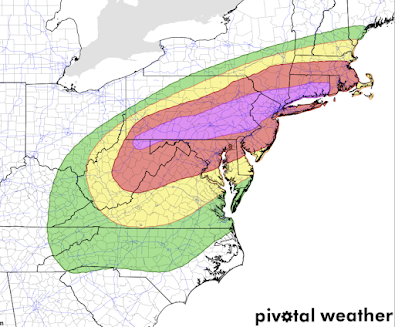
Extreme Risk of Flash Flooding in the Northeast

While this is the NWS's forecast, I choose to recharacterize the risk descriptions. 
  • Purple: Extreme risk of flash flooding.
  • Red: High risk of flash flooding.
  • Yellow: Medium risk.
  • Green: Slight risk.
This forecast is valid from tonight through 8am Thursday. I would add Garrett, Allegany and Washington counties of Maryland into the extreme risk area. 

The extreme risk is so important because 80+ of flash flood deaths occur in extreme risk areas. 

Update 443p,  ECMWF model shows torrential rains falling. 

Here is the latest radar, 4:44pm.

Moderate to, in places, heavy rain is falling over south central and southwest Pennsylvania. The heaviest rains in south central PA are expected to begin 4-8am Wednesday. 

Please follow local weather information for updates. 

Two Areas of Tornado Risk This Afternoon and Tonight

The brown areas have a significant risk of tornadoes. This includes Atlanta, Columbus, and Athens, Georgia. It also included the greater Washington, DC area across Delaware.

Right now, it looks as if there will be an enhanced risk of tornadoes in the Middle Atlantic area tomorrow. 


Update on Flood Risk

There's relatively little change in the rainfall amount forecast for Pennsylvania and Maryland. Serious flooding will likely result. 

Monday, August 30, 2021

High Risk of Post-Ida Flooding; Especially in Pennsylvania

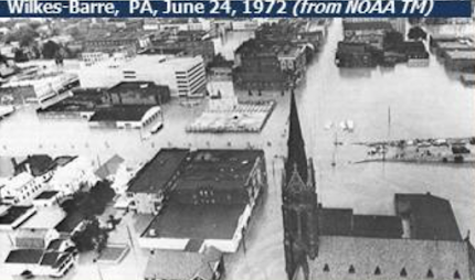
1972 Post-Agnes Flooding


Flash flood watches (below) are in effect all the way from Mississippi to the Atlantic Coast of New England. 

Green = flash flood watch. 

In view of the state's history of terrible post-hurricane flash floods plus the meteorological conditions over the next few days, I am especially worried about Pennsylvania. 

Here is the National Weather Service's rainfall forecast for the state, which is sufficient to cause flooding significant flooding.


However, the ECMWF model, statistically the world's most accurate --which was not available at the time of the NWS' forecast -- forecasts much heavier rains (below) of more than twelve inches. This is enough to cause catastrophic flooding. 

The Pennsylvania flooding threat is compounded by the fact that parts of the state have received as much as four inches of rain during the last three days (below), meaning a fast run-off of Agne's rain into already high rivers. In Harrisburg, the heavy rain is forecasted to begin Wednesday morning meaning a high degree of danger Wednesday night through Thursday night.

The Pennsylvania flooding after Hurricane Agnes took more than 100 lives and cost about $18 billion in today's dollars. 

It is vital that people living in the flash flood watch areas monitor the weather forecasts the next few days. Make you have at least three sources of storm warnings. It wouldn't hurt to prepare a "go kit" of essentials that you can grab and put in the car along with your family if you have to evacuate.

Another Triumph of Weather Science

The Damage From Hurricane Ida Was What we Feared. 
But, That Isn't the Big Story.
NOLA.com
NOLA.com
Hurricane Ida was everything we feared. NBC News has a well-done summary of the known, and extensive, damage, here. One local official this morning described the damage left by Ida as "epic." It will take months or even years to fully recover.

Once you have viewed the video, ask yourself: how many people would you have expected to die in this storm?

In 1957, Hurricane Audrey struck southwest Louisiana, largely without warning, with 125 mph winds. It killed more than 400 people. 

Yesterday's Hurricane Ida, which was stronger than Audrey with 140 mph winds and struck a densely populated, highly vulnerable area, so far has killed just one person. While that death is a tragedy for the friends and family of that person, it is fair to speculate that more than a thousand people would have been killed (given the much greater population of New Orleans and southeast Louisiana as compared with the area Audrey affected) had Ida struck without warning.  


Downstream of the weather forecast is the work of emergency management, local governments and the citizens who paid attention and acted upon the forecasts and advice from local officials. People got out. Others moved to shelters. They were out of harm's way and stayed safe.

New Orleans Times-Picayune

Meteorologists, whether from the National Weather Service, broadcast, or private sector, are heroes! Seeing some of the tweets from my colleagues made during the storm expressing concern for the safety of their fellow citizens almost made me tear up. Weather scientists comprise an extremely public-spirited profession. That showed again in the run-up to and during Ida as many of us stuck our necks out forecasting a "rapid intensification" storm -- something which is very difficult to forecast. Yet, we knew it was necessary to do so in order to have sufficient time to get people out of the way of the wind gusts of more than 150 mph and what could have been a killer storm surge of more than ten feet in depth.

Ask yourself: If we had been wrong, do you have any doubt the "false alarm" would have been the lead story of the national news today?

The above is not to say that everything went perfectly with the forecasts or the planning. And, the National Weather Service currently has serious issues with inadequate infrastructure among other challenges. There will be time to look at those aspects once the remains of Ida are off the coast and the heavy rains have stopped falling.

But, today, weather science: the forecasters, the broadcasters, the modelers, the social scientists and the entire team that makes up America's weather enterprise deserves a victory lap. 

If you know a meteorologist, drop her or him a note telling them how much you appreciate their work. It will be appreciated.

© 2021 Mike Smith Enterprises, LLC

Sunday, August 29, 2021

8:45pm Sunday Update on Hurricane Ida

Tragically, it looks like Ida turned into the monster we feared. Some items of importance:
  • New Orleans has been battered by winds of 80 to 110 mph most of the late afternoon and evening. One hundred percent of New Orleans and Orleans Parish (they call counties parishes in Louisiana) has lost power. Officials report "catastrophic" damage to the transmission network. That means the tall metal towers, etc., have been damage. That means days or even weeks without power.
  • Across the state, more than two million people are without power.
These giant electrical towers cannot be replaced overnight
  • There are varying reports as to the condition of the pumps. There is a flash flood emergency warning out for inner city New Orleans and there are reports the backup power could fail.
  • One major bridge has received structural damage. 
  • At least two hospitals have lost their roofs.
  • I-10 is completely closed due to debris. 
  • We don't know about casualties yet. 
The storm is finally starting to weaken. However, there will be the potential for deadly flooding all the way to New England

Note: I do not try to cover the news aspect of storms. That is well handled by Ginger Zee and others. This will be the last update for Sunday.

Forecast of DANGEROUS Inland Flooding

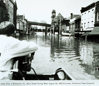
Camille-related flooding in Richmond, 1969

Serious Inland Flooding Risks
After 1969's Cat 5 Hurricane Camille, nearly as many were killed in flooding in the Middle Atlantic states as were by Camille's storm surge and winds. 

We may be looking at a repeat -- except, with modern meteorology, we have a chance to stop the deaths. The swath of red-orange-amber-yellow colors will see flooding. Please monitor your local meteorologists for updated information over the next few days. 

Three important points:
  • Note the 7+ inches forecasted over Pennsylvania and Maryland. Especially, given the mountains and the Keystone State's history of hurricane-related flood history, pay attention to the weather closely. 
  • From the Ohio River, south, most of the area already has very wet soil (map below) which will boost the flood potential. Darker blue = extremely wet.
  • There is serious flooding potential in Arizona due to the remains of Pacific Hurricane Nora. There is a lesser chance in western New Mexico and near the Four Corners.
The triple digit fatalities we had from flooding associated with Hurricanes Agnes and Camille do not need to recur. We can't stop the rain but we can certainly keep people out of harm's way and save lives.

Hurricane Ida Has Made Landfall

Radar 12:18pm CDT

As of noon, Hurricane Ida made landfall at Port Fourchon. Louisiana. It had sustained winds of 150 mph with a lowest pressure of 929 millibars -- a Cat 4 storm. Port Fourchon is a major energy center for our nation. 

Storm surge is forecasted to be up to 16 feet (!) which does not include tides and waves. Imagine being at the bottom of a sixteen foot deep swimming pool only with the water driven by hurricane-force winds. The destruction will be terrible. 

Below is a map of forecast wind speeds. Click to enlarge. 
Catastrophic structural damage due to the combination of storm surge and wind will occur. Power outages will last for at least days; 250,000+ people are already without power. That number will rise drastically.

Over and above the storm surge will be freshwater flooding in the areas in orange or yellow. Some of the inland flooding could be life-threatening. Please monitor this situation. 

Below is the relative flash flood risk.

There is a high risk of tornadoes between now and 6am Monday in the area outlined below.
Nadocast
If you are in southeast Louisiana, you need to shelter as if it were a tornado until the storm passes or weakens. 

9:40am Sunday: Hurricane Ida Update

Ida is an upper Category 4 hurricane and still strengthening. It has a good chance of making it to Cat 5 intensity. 

Below is the radar at 9:34am. Catastrophic damage is likely between the two arrows as the still strengthening eye moves WNW then NW. Winds are 150 mph and the central pressure is down to 931 millibars. 


New Orlean is just above the center of the image. I have highlighted the area with sustained 100+ mph winds and have hatched the area with winds of of 140 mph or stronger. It continues to move to the northwest. As the National Hurricane Center puts it:

If you are in the path of Ida, you must shelter as you would for a tornado: Closet or bath in the center of the house. If you have a helmet of some type, wear it. 

Below is the map of the forecasted wind speeds.

There is a tornado watch outlined in red below.

Power is already out in southeast Louisiana and those numbers will rise.

Don't bother with a generator today. Once the storm has passed, follow the instructions to the letter. 

2:10am Sunday: Ida Has Reached Cat 4 Intensity

And, I believe there is a better than 50/50 chance it will reach Cat 5 intensity. 


201a Satellite still shows lightning (colored symbols) around the eye which means the storm is still intensifying. Wind speeds were 130 mph with a pressure of 949mb. 

The storm surge, so far, is higher than forecasted. Get away from the coast immediately! 

The radar presentation is very impressive at 206a.


Final Forecast of the Night for Hurricane Ida. 1:25am

Storm Surge Flooding Has Begun as Ida Approaches the Coast. Moderate flooding has been measured at Slidell. And, the surge is higher than forecast at this point. The high tide later this morning is 10:36am which will be very dangerous.

Here is the position of the eye on radar. It is moving northwest pretty much as forecast. The strongest winds are in the right (east) half of the eye. Here is the image at 12:44am.

Sustained winds are 115 mph and the pressure is down to 955 mb. The storm is forecast to continue to strengthen up until landfall. I believe the eye will make landfall during the late morning. 
1:23am: winds are up to 129 mph and the pressure is down to 943mb. It is close to a Cat 4 storm now. 

At 1am, the new ECMWF model shows the storm easily reaching Cat 4, perhaps upper Cat 4 status, by landfall.
In addition to the storm surge, there will be major flash and river flooding. 

This will be my last update for the night. 

Saturday, August 28, 2021

10pm Saturday Hurricane Ida Update

Ida's Strength Has Not Changed Much the 
Last Three Hours

We can now see the center of the storm from the New Orleans radar. 
The open circle was the position of the storm's eye at 8:15. The closed circle was at 9:45. The storm continues to move east northeast but will turn more northwest during the night. 

Compare the satellite image from 9:40 to those earlier today in the postings below.
The black surrounding the eye has grown which is an indication that the strengthening that has been forecast is about to occur. 

The forecast of landfall has not changed much. Conditions will deteriorate during the night. Still expecting peak winds of around 130 mph. 

There is a high tornado risk from midnight tonight to 7am Monday.


FYI: The Hurricane Hunters have had to abort two missions today due to equipment problems. Not only that,  the NOAA Weather Radio in central Louisiana has failed. The Key West radar was out of service yesterday and NOAA suffered a major cable cut that connected it to its Boulder center. As well have discussed numerous times on this blog, the National Weather Service has serious issues. 

6pm Saturday: Complete Update on Hurricane Ida


The NWS NHC's forecast location of landfall has not changed since this morning. It could still come ashore 25 mi or so on either side of the forecast. I still look for the peak sustained winds to be ~140 mph with higher gusts. The areas that experience these winds will have catastrophic damage as they are equivalent to a high-end EF-3 tornado. There are sample photos at the very bottom of this post. 

Below is a map of the approximate wind field with Ida.

The 5:37pm satellite image shows a more symmetric eye than at 4pm. 
NO = New Orleans; M = Mobile; T=Tampa; Mi=Miami

At 4pm the maximum winds were 105 mph. The winds do not appear to have changed much since then. The central barometric pressure is 967 millibars. The pressure continues to fall rapidly with a fall of 4 mb in the last hour. 

Below is the area covered by the storm surge warning. Maximum surge is forecast to be 15' which does not include waves and tides. High tide Sunday morning is 10:36am. 

Below is the time by which you should have your preparations completed. 
In other words, be ready by 8pm this evening -- 1am Sunday at the latest. 

There is an extreme flooding threat!
If you live in the orange, gold or yellow areas flooding is highly likely. If you wish to evacuate and haven't done so, it is a better idea (other factors equal) to go west. Shreveport, Beaumont or Houston are good ideas. If you go east, you may have to do with flooding on your way back.

Here is the more immediate flash flood risk.


The area in yellow has an enhanced risk of tornadoes Sunday and Sunday night.
This includes Gulfport, Hattiesburg and Mobile. 

What I Recommend If You Are in the Higher Wind or Storm Surge Areas
  • Evacuate if you are told to do so. Before you leave, turn off water at the main valve and turn off electricity at the master switch. Charge your smartphone, laptop, etc., before leaving. 
  • Make a hotel reservation well inland.  If possible, evacuate to the west due to flooding concern over Mississippi and the eastern half of Louisiana. If you have the means, this frees up the shelters for people who cannot afford hotels, which is especially important given COVID. 
  • Figure out what you can fit in your car in the way of irreplaceable items like scrapbooks and family heirlooms. 
  • Make sure you have at least three ways of receiving vital warning information. 
  • Fully charge your smartphone and laptop before the storm arrives. Then, disconnect during the storm as power surges can damage your equipment. 
  • Prepare for power failures. If you have a generator, fill it with fuel. Do the same for your car. If you want a generator, have a professional install it.  
  • Get extra cash at the ATM. Credit cards don't work if the power fails. 
  • If you have a chain saw, fill it with fuel. 
  • Clean out gutters. 
  • Install your hurricane shutters or board up windows.
I am providing frequent updates @usweatherexpert on Twitter. Note: I am calling out politics and weather porn. If I am online, I am happy to answer questions. 

Note: Politicians, regardless of party, are terrible sources of meteorological data, especially in emergencies. 
Fact: We don't know how bad Ida will be until it comes ashore! All of this "worse than Katrina" and other nonsense is just weather porn. Please follow the information in this post and from @NHC, @Accuweather and other reliable sources. 

Dr. Roger Pielke, Jr. has an essay on hurricanes that have struck in the vicinity of New Orleans. This will be very useful if you are looking for scientific perspective. 

Sample damage from a tornado of the approximate strength of the peak winds forecasted for Hurricane Ida. This was from a tornado in the New Orleans area.