Posts

Showing posts from 2020

Winter Storm Update: 4:20pm New Year's Eve

Image
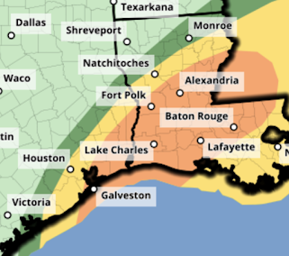
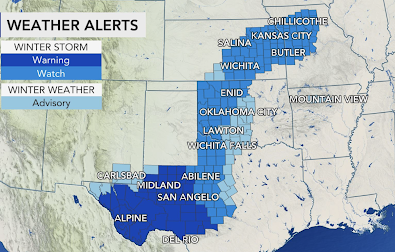
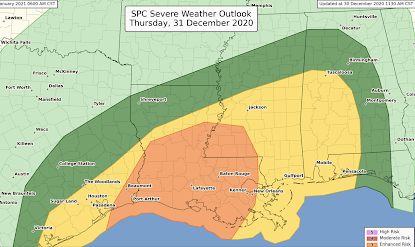
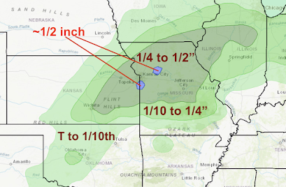
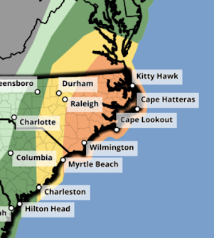
Power Failure Forecast The orange areas have the greatest chance of power interruptions and some of those could last hours or a day or two. Please prepare accordingly before the precipitation begins!  The area from Ft. Scott to the Lake of the Ozarks up to Columbia appear to be most vulnerable.    Farther east,  The storm will spread east on Friday and Friday night. AccuWeather is forecasting enough ice for power failures in the deep purple areas. Again, please prepare accordingly.  Storm Overview A lot going on. Purple = freezing rain warning.  Pink = winter storm warning for snow or ice. Blue = winter weather advisory (a lesser condition than a warning).  Green = flood watch. Yellow = tornado watch. 

Tornado Watch Issued: SE Texas and Louisiana

Image
Tornado Watch Until 9pm I am posting this because the NWS SPC website is not working properly. Please let friends and relatives know because they are forecasting "strong" tornadoes. 

Update on Major Winter Storm

Image
Overview Here is a rundown of the major winter storm affecting the nation east of the Rockies. Purple = ice storm warning (near Mason-Dixon line). If it were me, I'd have an ice storm warning out in parts of Missouri (see below). Power failures are likely. Pink = winter storm warning.  Deep green = winter storm watch.  Purple = winter weather advisory (lesser condition than a warning). Green = flood watch. Remember, "turn around, don't drown." Yellow = tornado watch. There is a threat of tornadoes farther east later today (see below). Power Failure Forecast Yellow areas could have isolated power failures. Orange areas have a good chance of scattered power failures. I believe south parts of the KC Metro could see some power failures.  Tornado Threat Forecast The orange area has an enhanced chance of tornadoes this afternoon and evening. The yellow area has a significant risk of tornadoes. Please keep up on your local forecasts and warnings. 

Ice Storm Forecast to Move Northeast

Image
 From AccuWeather...

New Year's Eve Fun: Be Careful Out There...

Image

Enhanced Risk of Tornadoes New Year's Eve

Image
There is an enhanced  risk of tornadoes in the orange area beginning after 10am. There is a significant risk in the yellow area.  I'll have more on this threat later today. 

More on Power Failure Potential

Image
The Sperry-Piltz Index is the standard in the electrical industry for forecasting outages due to ice and snow. Descriptions are below. There will be some local ice accumulations of .7 to .9 inches near the Missouri-Kansas border. In those localized area, the index will push slightly into the "3" category. Please prepare accordingly. Scroll down for preparation suggestions.

The Sunset Before the Storm

Image
Taken in Wichita at 5:35pm.

Major Winter Storm on Tap for Central United States

Image
Via AccuWeather, here is a summary of the winter storm watches and warnings.  Extreme snows are forecast for southwest Texas where more than a foot is expected to fall. This will cause extreme travel difficulties as the region is not used to dealing with this much snow.  Farther north, a major snow and ice storm is likely.  Freezing Rain - Ice Storm  These are major ice accumulations. When combined with the wind (see below), power failures are likely  in addition to extreme travel difficulties. Safety suggestions will be found below, also. Heavy Snow There will be drifting snow which will make travel difficult. Recommend traveling before the storm arrives or waiting until crews have cleared the roads.  Wind This map is the peak  gust from 3am Friday (New Year's Day) to 11am Friday. Given the ice accumulation on power lines, the wind will  cause power failures. I'll have more on the power failures between 5:30 and 6pm  as more data arrives. Also, in the snow areas, near blizzard

Serious Risk of Tornadoes in the South Thursday

Image
UPDATED... There is an enhanced  risk of tornadoes in the yellow area. The highest threat will be from the mid- afternoon through the evening hours. This includes Beaumont, Hattiesburg, and most of the southern two-thirds of Louisiana, including Baton Rouge and New Orleans.  There is a significant risk of tornadoes in the yellow area. The tornado will will begin in southeast Texas in the mid- to late morning (including Houston and Beaumont) and will continue through the night in Mississippi, Alabama and Florida.  This is an important weather situation and I urge you to monitor it if you live in the affected area. 

Winter Storm Update - 10am Wednesday

Image
Here is a quick update on the New Years Winter Storm. Heavy snow will begin soon in southwest Texas. The storm will move northeast and intensify.  Green = flood watch.  Pink = winter storm warning Blue = winter storm warning. Purple = winter weather advisory (a lesser condition). I'll have a complete update late this afternoon. 

PRELIMINARY: Major Winter Storm Likely Later This Week

Image
There is the potential for a crippling ice and snow storm late this week in the Great Plains Preliminary Freezing Rain (Glaze Ice) Forecast Freezing Rain Accumulations Noon Thursday to Noon Friday. Of course, amounts may shift up to 50 miles in any direction. The ice amounts would be bad enough but they will likely be accompanied by high winds (see below). So, if this forecast is correct, not only will travel be disrupted but there is the potential for serious power failures that could last hours or days.  Preliminary Snow Amount Forecast  Snowfall Forecast From 6am Thursday to 9pm Friday There will likely be drifting snow based on wind speed forecasts for 6am Friday. Wind Gust Forecast For 6am Friday Pale blues are gusts of 30-35mph. Light greens are 40-44 mph. Currently, a NWS winter storm watch is in effect from Thursday afternoon into Friday night for the tinted counties. The watch will likely be expanded Wednesday. The watch includes Wichita, Salina and Woodward.  This is still a

Ridiculous Windmills Strike Again

Image
With the winter storm in progress in the Great Plains, I went to radar network to try to determine when the rain will end in Wichita. The Vance radar's data looked funky, so I went to the radar status messages and found this.  We knew this day was coming: The essential WSR-88D radar north of Vance AFB in Oklahoma has been compromised by the dense placement of windmills in northern Oklahoma and southern Kansas. And, it isn't just that radar.  We run the risk of deteriorating radar and storm warnings because of windmills in many states. Below is a screen capture of the Dodge City WSR-88D radar a few minutes ago. I've circled the wind turbines. And, it gets ever worse -- nearly by the month. In mornings, when there are often temperature inversions, ground clutter due to wind turbines is even worse! In spite of literally millions of windmills worldwide, they have: Not made a significant impact on decarbonization.  Have  destabilized  the electrical grid.  Do  not  provide elect

Essential Storm Warning App for Your Smartphone

Image
Even though I haven't worked for AccuWeather since 2018, I tout its app for storm warning use. Now, it has been named the best storm warning app in the world  by the World Meteorological Organization, which part of the United Nations. Specifically, it was named: Best for storm warnings  Best design and presentation of information Best user interface I think you'll agree that is very impressive. The thing that makes the app so useful is that it follows your location and only sends warnings if they are pertinent to you -- which minimizes false alarms. It is also very fast: it provides warnings faster or as fast as other sources.  Congratulations to my friends and former colleagues!! 

Active Weather: Ice, Snow, Floods

Image
The weather will be very active across the nation this week. Courtesy of AccuWeather , these maps spell out the winter storm threat: There will be freezing rain from northwest Oklahoma to western Michigan. This will create slippery roads. Please factor this into your travel plans.  The map above is a good depiction of the snow forecast -- however, there will be snow today from Denver across northeast Colorado and into northwest Kansas that is not depicted on this map (which starts tomorrow).  Flooding may develop in Arkansas and adjacent areas due to very heavy rains for this time of year.  There is also a chance of tornadoes and severe thunderstorms later in the week. I'll update on that possibility if it develops. 

In Case You are Traveling Later This Week

Image
Preliminary Forecasts: Major snow storm in some areas from the Intermountain Region to the Great Lakes. There is also the risk of a mild to moderate period of freezing rain in the Great Plains.  I will provide updates on this developing storm. 

Sunday Fun: Dave Barry's "Year in Review"

The perfect way to end a lousy year. With today nearing the end of the NFL's season, I especially enjoyed this excerpt from his June entry: The National Football League is also trying to adapt to the pandemic, exploring the possibility of a season with no fans, no coaches and no players. “We’re thinking of just showing 60 minutes of referees throwing penalty flags and peering at replay monitors,” says NFL commissioner Roger Goodell. “So it won’t really be much different.”  Read more here: https://www.miamiherald.com/living/liv-columns-blogs/dave-barry/article247890015.html#storylink=cpy Thanks, Dave . 

Thank You For Your Endorsement

Image
Charles is the former president of the Kansas Soybean Association. I appreciate his endorsement of When the Sirens Were Silent  which is the story of the Joplin Tornado.  If you received a gift card for Christmas....  

China's Alleged Weather Control - Note It Is "Opinion"

Image
I don't know what the deal is with Bloomberg 'opinion' but they have run multiple stories praising the success of China's weather control program. Except it is all baloney. Below is a small sample. It is scientifically impossible to break a drought with cloud seeding. Why? There are no clouds to seed.   Is it possible they have had some success lessening hail? Possibly. We don't do it in the United States because they know there will be tremendous litigation. 

Merry Christmas!!

Image
Love this photo from NBC News. The Rockefeller tree is in the background. 

Christmas Eve 1968: Apollo Reading Genesis From Lunar Orbit

Image
Until 2020, 1968 was the worst year I could remember. The assassinations of Dr. Martin Luther King and Robert Kennedy. The riots. Awful year. In December, Apollo 8 was the first trip of humans to lunar orbit. Everyone in America watched.  Dr. Glenn Reynolds commented that Apollo 8's amazing Bible reading "saved" 1968. It is tragic America's elites have lost their faith and that communal prayer was not done this Christmas. 

Enhanced Tornado Risk

Image
The orange area has an enhanced risk of tornadoes this afternoon.  The yellow areas have a significant risk of tornadoes the rest of the day.  Please keep up on the weather in these regions.

I Have My Vaccination Mark

Image

Unseasonably Heavy Precipitation From Coast to Coast

Image
Desperately needed rains are forecast for California, the Southwest and the Four Corners region. In the Great Plains a winter storm -- perhaps a major winter storm -- is possible. Heavy rain is forecast along the East Coast tomorrow. 

Enhanced Tornado Risk Christmas Eve

Image
There is an enhanced risk of fast-moving tornadoes in the orange area -- from about Newport News to near Myrtle Beach and as far inland as Raleigh.  There is a significant risk of tornadoes in the yellow areas which are as far north as Richmond.  Please keep up on the weather in this area tomorrow as well as along the Gulf Coast later today (see posting below). 

Pre-Christmas Tornado Threat

Image
Now Until 6am Thursday The yellow area has a significant threat of tornadoes later today and tonight.  6am Thursday to 3am Friday Morning (Christmas) The yellow area has a significant risk of fast-moving  tornadoes. So, it will be especially important to monitor the weather. This area may have to be expanded in later outlooks. If so, I'll update the forecast later today. Please be aware of this if you are traveling or have relatives in these areas.  

Blizzard Warnings!

Image
This is a major storm, so if you are traveling please  avoid it. Orange is a blizzard warning.  Pink is a winter storm warning. Gold is a high wind warning. Blue is a winter weather advisory (a lesser condition). Magenta is a wildfire danger warning.  Gray is a dense fog warning for travelers.  While this is very preliminary, there is a chance of another major winter storm in a week to ten days over the central U.S. 

The Quarantine Blues

Image
From the great Ray Stevens.  

Christmas Albums

Image
A friend had a thread on this topic on Twitter this morning. So, here are my 2¢. While my favorite single Christmas song is The Christmas Song  by Nat King Cole, my favorite Christmas album -- by far -- "Christmas Portrait" by the Carpenters.* I fell in love with the album the first time I heard it when it was released in 1979. Especially moving was Karen's performance of Have Yourself a Merry Little Christmas. Her singing the words, "Through the years we all will be together, if the fates allow" moved me at the time because of the importance of family gathering. Little did anyone know in 1979 how ill Karen was and how, just three short years later, she would be gone. If you can listen to the original vinyl, please treat yourself. * Unfortunately, it is nearly impossible to get a copy of the original "Christmas Portrait." Surviving brother Richard has created numerous "special editions" and other versions that, at least to me, are not as movi

The Grand Conjunction

Image
The Grand Conjuction is at upper right as seen from my patio in Wichita. I'm pretty underwhelmed. 

Space Corps Logo?

Image
Am I the only one bothered by the mission of our newest military branch's tagline not mentioning freedom, liberty, honor or any of our other traditional values? How can they have "heritage" when they have existed for less than two years? And, what is with the "Guardians"? I agree with Homer Hickam. They should be the Troopers.  The Trump Administration really whiffed with this one. 

Sunday Fun: The Chefs

Image
Seeing the "1" numeral reversed on the Titan's field reminded me of this commercial involving my favorite team.

Required Reading: The Catastrophically Wrong Global Warming Predictions for 2020

The only thing catastrophic about global warming is the quality of what was supposed to occur by 2020.  Please read the list, here .  I would add the trend toward fewer violent tornadoes continued.  While the sea level forecast for 2020 was wildly wrong, don't discount it entirely. Extrapolated over a century, it would be an increase of a foot -- what is significant. The solution, as we have discussed numerous times, is nuclear energy. It is a shame the environmental groups would rather have the issue than a solution. 

Tonight's Sunset

Image
Another beautiful Wichita sunset. 

The View From My Easy Chair

Image
December 17, 2020.