Sunday, April 30, 2023

Yesterday's Tornado Warning Failure in Florida

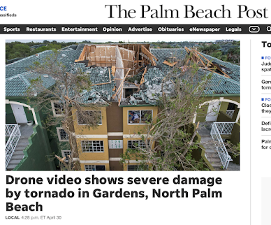
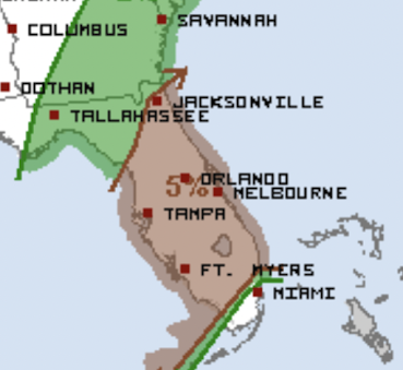
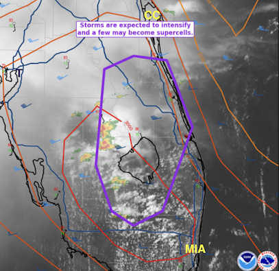
There is an exceptional number of exceptional close-up videos of yesterday’s Palm Beach Gardens (PBG) Tornado. After seeing the ever-increasing number into this afternoon I thought, “Why weren’t they taking cover?” Based on a quick look yesterday, it appeared the tornado warning was timely. Unfortunately, it turns out it was not.

Now that the National Weather Service’s (NWS) survey of this strong tornado (EF-2 intensity) is complete, it is important to note that the tornado warning was not issued until the tornado had been on the ground for two minutes. The NWS's goal is for the tornado warning to be issued 13 minutes in advance, so this warning fell far short. Fortunately, there were no injuries. 


Of course, it is not possible to issue a tornado warning in advance of all tornadoes. Such is the state-of-the-science. But, there are many reasons to believe there could have been advance warning of the PBG tornado – about ten minutes’ worth. This is especially important as this tornado cut through a densely populated area. 


The West Palm Beach region is served by multiple radars. Unfortunately, the primary National Weather Service (NWS) radars are rather distant: The Miami radar is 87 miles away and the Melborne radar is 98 miles. The NWS office responsible for warning West Palm Beach is the Miami office and, unfortunately, they were not running their radar in the proper mode for tornado conditions: The radar was updating at only 4-minute intervals. The more distant Melborne radar was being operated properly with updates every 1.2 minutes, which is the best possible. Running the radar at the wrong interval during tornado situations has become a frequent problem across the NWS. 

Miami National Weather Service radar showing 
strong rotation at 5:02pm EDT.

Melbourne National Weather Service radar showing
moderate rotation farther southwest than Miami's at 5pm.

Why is the interval important? Tornadoes can form quickly as they did yesterday. The Melborne radar indicated a tornado warning should be issued because of “gate-to-gate” (highly concentrated) Doppler wind rotation at 5:00pm EDT. The key radar, Miami’s, because of the less frequent updating, did not indicate the tornado warning was needed until 5:02 EDT. Still that would have been eight minutes before the tornado formed. It is hard to understand why this wasn’t done.

The tornado warning for Palm Beach Gardens that was 
issued at 5:12pm EDT.


Gate-to-gate is not the only criterion. There are several criteria meteorologists look for when deciding to issue a tornado warning. Here is how they stacked up, with one exception, as of 5:00pm.

  • General meteorological conditions favorable for tornadoes. Present. Tornado watch in effect.
  • Right-moving supercell (radar).  Present
  • Jump in lightning activity (satellite) as of 5:06pm. Present
  • Enhanced Vee (satellite). Present
  • Doppler wind velocity couplet (radar). Present
  • Hook echo (radar). Not present until after the tornado formed.  
Lightning jump as seen from GOES weather satellite at 5:06p


In other words, by 5pm, this was a straightforward warning situation. Yet, the warning was not issued for another twelve minutes, two minutes after the tornado touched down. I believe a timely warning would have been issued in, say, 2008 in an identical situation. 


Yes, I am saying the NWS's tornado warning program, rather than improving, has deteriorated in the past 15 years. 


There seem to be three issues plaguing the NWS’s tornado warning program. 


1.     Retirement of my generation of meteorologists. The experience of learning how to issue tornado warnings with black and white, non-Doppler radar progressing into the Dopper era, then adding satellite data cannot be replicated. Experience cannot be taught.

2.     The NWS’s relatively recent emphasis on reducing false alarms -- without providing any proven scientific techniques for doing so. False alarms have gone down by 2% -- while the accuracy of tornado warnings has gone down 14%. Lead time, the interval from when the warning is issued to when the tornado forms, has dropped from a nearly ideal 13.3 minutes to just 8.4 minutes.  

3.     Some NWS local offices appear to have made the tornado warning process too complicated. 


The National Weather Service used to investigate its performance after major disasters through what it called, "Service Assessments (SA)." However, for all intents and purposes, the NWS has stopped doing them except in rare situations. The last Why? Because most of the problematic meteorological situations of the past five years have featured issues with the NWS's performance. Thus, there was a SA for 2021's Hurricane Ida (not released until April 2023!), where the NWS did well, but not a Service Assessment for 2022's Hurricane Ian, where the NWS's performance left a lot to be desired. 


Congress has been holding hearings on the topic of making the National Oceanic and Atmospheric Administration (NOAA) an independent agency. Now, it serves under the Department of Commerce. While I am not aware of Commerce’s attitude toward the NWS under the Biden Administration, under the Trump Administration Commerce knew there were serious problems. Regardless, we have yet another head of NOAA with no background in weather – which has been continuously the case since 1974! 


So, I do not support making NOAA an independent agency unless – simultaneously – Congress creates a National Disaster Review Board (NDRB) modeled after the National Transportation Safety Board (NTSB). The NDRB would not just review the performance of NOAA, it would look at FEMA, the Red Cross, and state and local entities, both public and private sector. And, like the NTSB, it would make recommendations to the agencies, Congress and the President as to what went well and what did not, with suggestions for improvement. 

Sunday Fun: The Snow Is Melting in Utah


Sober Words Worthy of Consideration

Saturday, April 29, 2023

Heads Up (Again): Florida!

There is a significant risk of tornadoes during the night, most likely after 1am and into mid-morning Sunday, in the brown area. 

Please make sure you have your weather radio and WEA alerts activated and near your bed during the night.

Way, WAY Too Close to a Tornado!

If you want to see what it looks like to be inside a tornado go here. This was in Palm Beach Gardens, Florida, as our forecast of tornadoes (below) was correct.

Here is what the storm looked like from a distance:

FYI: Over the past 30 years, Florida ranks #4 for tornadoes. Below is from a professional meteorologist in Florida.

Increasing Chance of Severe Thunderstorms and Tornadoes in Florida

As of 2:30pm EDT, the NWS SPC has outlined (purple) the area where supercell thunderstorms, which may produce tornadoes, are forecast to occur the rest of the afternoon and into this evening. 

Below is the radar from 2:33pm. 
The storms are generally moving toward the northeast. Please be weather aware if you live in the purple outlined area above. 

This Week's Rainfall

This week's rainfall ending at 7am CDT this morning. 

Below is the drought conditions as of Tuesday morning, so the rain after that time does not count into the calculations. 
While the rain this week certainly helped, it will take as much as ten inches more than average to break the drought in some areas. 

Today's Tornado Risk

The area in brown has a significant risk of tornadoes this afternoon and evening. I urge you to keep up on the weather as a low pressure system moves inland from the Gulf. 

Like Water Runs Downhill...

The wind may be calm and the turbine not turning but we keep paying for it -- on several levels. 

Friday, April 28, 2023

Tornado and Severe Thunderstorm Watches in Texas

Tornadoes are forecasted to occur along with wind gusts of 75 mph and hail up to 3 inches (!) in diameter. 

If you reside in the watch areas, please monitor the weather the next few hours.

Severe thunderstorm watch, including the DFW Metroplex.
Hail up to 2" and thunderstorm-generated wind gusts to 70 mph are forecasted to occur. 

Hail to 3" and wind gusts to 75 mph are likely. 

The severe thunderstorm watch below is in effect until 10pm. 

Severe thunderstorm watch for the Rio Grande Valley.

Damaging Weather Forecast for Texas

There is a small chance of tornadoes in the northern part of the orange area near Waco. However, the greater threat is giant hail and damaging winds of more than 75 mph -- which will lead to power failures. 

Addition at 12:30pm from NWS Storm Prediction Center:

Here is the forecasted timing for central Texas.

I urge you to prepare! How? 
  • Put your car in the garage. 
  • Bring in lawn furniture or other items that could be damaged by wind or hail.
  • Fill your car with fuel.
  • If you have one, fill your generator with fuel. 
  • In case of widespread power failures, it would be a good idea to get a little extra money from the ATM. 
I'll update late this afternoon or evening. 

If You Don't Think You Need to Shelter For Tornado Warnings...

I think this video will change your mind. 

And, if you think it is a good idea to go outside to view a tornado, consider this:
Once rain wraps around a tornado, it becomes invisible. This tornado, which occurred this past Wednesday, killed two in Oklahoma. 

Finally, in this screen capture from Pecos Hank, a reminder that if you don't have a tornado shelter or a basement, the place to shelter is in a small room (closet, bath) in the middle of the lowest floor of the house. 

Finally, Dr. Craig Ceecee has assembled a list of public shelters. Go here and then zoom, and then click on the location of interest. It will provide with the exact street address. This is particularly useful for mobile home dwellers. A sample is below. 
However, if you use a public shelter that is more than a short walk, you will need to allow extra time to arrive due to possible auto traffic in the area. If there is a tornado watch in effect and thunderstorms, go ahead and move to the public shelter. 

Thursday, April 27, 2023

Come See Me in Dallas!

I'll be appearing at Love Field's Frontier's of Flight Museum on Saturday, May 6. 
I'll be speaking about downbursts at 11am. If you have a copy of one of my books, I'd be happy to autograph it for you. I'll also have copies of Warnings for sale. The price will be $20, including tax.

Today's Tornado Risk

The brown area has a significant risk of tornadoes later today. Please keep up on the weather later today and this evening. 

Wednesday, April 26, 2023

If You are Traveling to Kansas City for the NFL Draft...

....the forecast for 7pm is for cloudy skies, a slight chance of a sprinkle, and a temperature of 58°F, 

Overnight Tornado Risk

The tornado risk until 7am Thursday. 
There is a significant risk of a tornado in the brown area. Damaging thunderstorm-generated winds are possible, also.

This is the end of my weather coverage for today. 

Tornado Watch Central Texas

UPDATED INFORMATION AVAILABLE ABOVE; SCROLL UP

-- original post --
Tornado Watch until 10pm.
It includes south portions of the Metroplex. 

Strong tornadoes are possible along with 75 mph thunderstorm-generated wind gusts and hail stones to 3.5 inches in diameter. 

Please closely monitor the weather through this evening as the tornado risk may spread east and possibly as far south as Austin and College Station. 

Follow me on Twitter @usweatherexpert for additional coverage as the storms develop. 

Anniversary of the 1991 F-5 Wichita-Andover Tornado

The tornado was on the ground 50+ miles and did tremendous damage. However, according to a study by the Centers for Disease Control, the tornado warnings saved more than 70 lives. 

If you would like to read what it was like to be a meteorologist that day, go here

The meteorology of that day is here

Video of the F-4 in Cowley County (40 mi southeast of Wichita) is here

And, my coverage is below. 

Serious Tornado Risk in Texas

Scroll up for later information. 

== Original Posting ==
There is an enhanced risk of strong tornadoes in the yellow, hatched area. There is a significant risk of tornadoes in brown area. 

Please pay attention to the weather in these areas later today. I'll update this afternoon. 

Tuesday, April 25, 2023

Wet Cows -- More Rain!

Mark Smith
The cows had wet hair this morning in the Gyp Hills of south central Kansas...something that hasn't occurred in quite a while. Here they are seen being bed their breakfast.

Below is the rainfall amount map to noon today. First up is a general (smoothed) rainfall map. We are focusing on the winter wheat belt.

Below are the latest amounts from the Kansas and Oklahoma Mesonetworks. Just click to enlarge.


Below is the rainfall forecast from 7am this morning to 7am Thursday.

Today's Tornado Risk

The brown area has a significant risk of tornadoes. 

Pal-Review, Not Peer-Review

Dr. Judy Curry is one of the most prominent climate scientists in the United States.
The fascinating thread is here. In climate science, this is known as "pal review" rather than "peer review." 

Over the weekend I had, for the umpteenth time, the conversation with a person who calls himself a climate scientist and I asked him "what is earth's optimal temperature for humanity to flourish?" when he was proposing geo-engineering to cool the earth. You can see the exchange -- with the predictable reply -- below.

Above is his reply. I'm intentionally leaving off his name.
So, we have this clique of climate 'scientists' that won't even attempt to answer some of the most very basic questions involving the climate and its relationship to humanity. That would seem rather important, especially if we are going to try to cool the climate with the giant risk of shortening growing seasons and causing famine.

Finally, I'm quite familiar with climate science but, as David points out, this cancer occurs in other areas of science.

Monday, April 24, 2023

Desperately Needed Rain Falls in Great Plains

Below is the forecast rainfall (snow in Colorado above 6,000 feet) from now until 6pm Friday. 

Here is the latest drought map.
The darkest brown color is where the drought is the worst. If the forecast is correct, it will be helpful but it will not break the drought. 

Addition regarding the snow in Colorado.

Addition at 11pm Monday:  24-hour rainfall.

Do Facts Matter? Wind Energy Flops Again -- Big Time

Yesterday's Wall Street Journal had a story about how the Biden Administration is spending three trillion dollars (that bankrupt America doesn't have) to bribe communities into going along with its global warming 'solutions.' People and organizations believe they can get rich. Unfortunately, as the Obama Administration proved with now-bankrupt solar energy firm Solyndra, battery company A123,
and others, the only people who get rich from this graft are the insiders. Meanwhile, we spend ourselves into energy poverty. 

Don't believe me?

Winds were light over Alberta, Canada, Friday evening. So, wind power production fell to much less than 1% of capacity. Fortunately, temperatures were mild. But, that less than 1% figure should terrify you. Think about what would have occurred had temperatures been below zero or, in the United States, above 100°F. As they did in Texas in 2021, people die by the hundreds. And, after the initial tsunami of federal cash, the inevitable bankruptcy is filed. 

It is even worse: in Germany -- where they just shut down their last three nuclear power plants -- all fossil fuel home heating installations will be illegal after January. Politically, the USA is headed the same direction as the Biden Administration wants to "electrify everything."

If you aren't happy with the combination of higher electric rates, less reliable electricity and making China rich in the process, it is time to make your state legislators and your congressional delegation aware of your thoughts. 

Sunday, April 23, 2023

Sunday Fun: "If the Tornado Doesn't Come to the Mobile Home, Take the Mobile Home to the Tornado"

As I was taking photographs of the supercell thunderstorm in Chase County, Kansas, Wednesday evening, I didn't get to see Channel 3's excellent storm coverage. Kathleen taped it for me, and I was amused to see a mobile home being hauled toward the tornado*!

Because it was dark, they could show the tornado only during lightning flashes. Here's a better view of the tornado.
Fortunately, there were just three minor injuries and the damage was not severe. 

*If you look at the lower right, you'll see a flashing red light. That is the end of a BNSF train stopped by an AccuWeather track-specific tornado warning.