Posts

Showing posts from November, 2014

Cold Front: Winds and Temperatures

Image
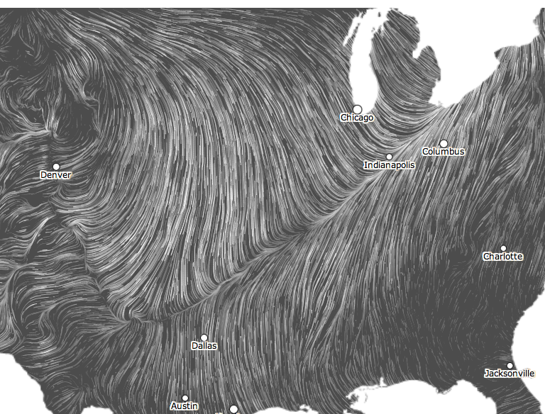
Here the most recent information available: Winds Temperatures For the prime-time Broncos versus Chiefs game this evening, the kickoff temperature will be about 25° with a wind chill of 13°. Winds will be out of the north with gusts to 23 mph.

You May Want to Time Your Gasoline Fill Up...

Image
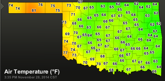
…so that you are on the southeast side of the cold front. Dr. Ryan Maue, click to enlarge Given the temperature drops more than 20° in a few miles, your Thanksgiving return travel would be more pleasant if you stop before you get to the cold front. And, speaking of travel, here are the airport delays as of this moment: Denver, 59 minutes San Francisco, 2 hr. 49 min. Los Angeles, 15 minutes O'Hare, 30 minutes West Palm Beach, 60 minutes White Plains, 45 minutes Hope you and your family had a great Thanksgiving. We certainly did. ADDITION: 3:42pm. Here is what I mean. I you are traveling on I-35 you may want to fill up in Ardmore, Okla., where it is 77° versus Norman (~ 30 mi. away) where it is 50° with a strong north wind. In the OKC metro area, temperatures are in the mid- to upper 40s.

Update on California Drought

Image
Here is the rainfall from the last 24 hours. And, here is the rainfall the last two weeks. Keep in mind that much of Southern California's water comes from reservoirs in Northern California. So, these rains are even helping Los Angeles. More generous rains are forecast for the nest seven days. On Monday night or Tuesday, we will have information from the National Weather Service that will indicate the extent to which the rainfall through Saturday morning has helped the drought. My sense is that, by the time December 15 rolls around, roughly half of the needed rail to break the drought will have fallen. Keep your fingers crossed.

Slippery Travel on Monday

Image
There should be no problems prior to sunset this evening. However, late tonight and Monday some light freezing rain or freezing mist may occur in these areas. The highest probabilities will be in the Ozarks.

Update on California Rain

Image
Here is the latest AccuWeather regional radar at 7:45am PST. The heavy rains around the Bay Area are causing average delays at SFO of 1 hour, 51 minutes. More rain will be spreading across the state today. Later today on the blog, we will have more information on the status of the California rain.

More Silly Meteorology Stories

Image
My gosh, how many of these stories are going to be written this month? This one accuses meteorologists of lying in their forecasts. I can't speak for The Weather Channel, but I can tell you that AccuWeather , our founder Dr. Joel Myers, and every employee of the company is passionate  about providing the most accurate forecast possible. We spend a tremendous amount of money (i.e., purchasing the output of the European model) to achieve that goal. Never once -- not once -- in the eight years I have been part of AccuWeather has anyone ever suggested hyping a weather situation. This blog and Mike Smith Enterprises is also dedicated to providing the most accurate science and information possible without regard to politics or other considerations. And, New York's Governor Cuomo can't seem to get his story straight . At first, he lied (yes, lied) about the Buffalo office of the National Weather Service not forecasting the blizzard. They did and they did a great job. Then,

Football Freeze Coming

Image
Temperatures have dropped 50° in Montana today compared with yesterday. While people are watching the Kansas State-Kansas game with 70° temperatures, don't be fooled. When the Kansas City Chiefs play Denver in KC tomorrow night, the temperature will be 28° with an AccuWeather Real Feel® temperature of 15°!

Faster, Please

An entirely new approach to "switching off" chronic pain .

California: The Rains Begin!

Image
Here is the current radar which shows rain spreading across California north of I-80. The National Weather Service is forecasting  additional  precipitation as much as 9 inches over the next seven days. The hills around San Francisco Bay are forecast to receive as much as 5.8 inches.  The long range forecast models show additional rains falling in California on days 8-10. This will not break the drought but it will dent it if these forecasts are correct. 

Thanksgiving Return Travel

Image
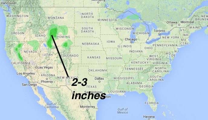
The darker green is 2-3 inches of snow during the 24 hours from 12:01am to 11:59pm CST Sunday. Lighter green is less than two inches. I-80 in southeast Wyoming and over the Sierra could have some slick spots but no major problems are expected anywhere in the U.S. Below is the weather map for 11:59pm Sunday night. The tinted areas are precipitation with the darker colors indicating heavier amounts during previous 24 hours.

One of the Best Books About Weather Ever Written...

Image
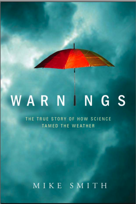
…say the critics and readers. It makes a great gift but Amazon (at this moment) is down to nine copies. Also available at Barnes & Noble and your local book seller!!

Start Planning for 2017

Image
click to enlarge I guess I should tell my tale of woe regarding the last solar eclipse I attempted to see. Notice the word, "attempted." In 1991, I took my entire family to Hawaii to see a total solar eclipse. The kids had never been to Hawaii and I thought it would be a great family trip. The area of longest totality was between the islands of Maui and Hawaii. So, I booked the family on an eclipse cruise. The weather was fine when the ship left the dock. But, it poured down rain during the eclipse and the family was terribly disappointed, especially since they had to get up a 4am. All they could see at the time of totality was clouds, rain, and darkness. People on the boat were literally crying with disappointment. As we were reaching the dock to disembark, my son, Brandon, said, "Well, I had a good time, Dad." [Gratefully!] Thank you, Brandon, I am so glad to hear that!! Brandon, "Not!!"
Precipitation Forecast for the Next Week

Image
Generous rains being forecast for California with a number of spots forecast to have six inches or more. Below is the amount of rain (in addition to normal) needed to break the California drought and the various dry spells around the nation.

Happy Thanksgiving

From Mike Smith Enterprises, LLC . Mindy and I wish you and yours a great day of family and fun.

The Greatest Thanksgiving Program Episode Ever!

"As God is my witness, I thought turkeys could fly."

California 14-Day Rainfall Outlook

Image
Here is an outlook of potential precipitation (snow in the Sierra, rain lower elevations) over the next two weeks. I believe the computer is underforecasting amounts over Donner Pass (between Colfax and Reno), so I have pulled the 7-9" in area into that region (see arrows). There is a pretty good chance a "Pineapple Express" may set up. If that occurs, some of these amounts may be too low but that is too soon to pin down. The rain will start near the Oregon border during the day Friday reaching San Francisco on Saturday. The generous rainfalls should extend south into the higher elevations of Los Angeles and Orange counties next week. If this forecast is correct, it will significantly dent the drought.

1:45pm CST: Winter Storm Update

Image
Extraordinary snowfalls being documented in West Virginia and other higher elevation locations. Davina Wagoner via Twitter Airport Delays at 1:41pm: Boston, 1 hr.  13 min. Newark, 2 hr.  28 min. JFK, 1 hr.  19 min. LaGuardia, At least 2. 5 hours. Having problems with runway equipment.  Philadelphia, 1 hr.  29 min.  Dulles, approximately 30 minutes Reagan, 26 minutes Minneapolis,  47 minutes AccuWeather Regional Radar at 1:40pm Forecast Regional Radar at 7pm EST By 7pm, the snow should be over at Reagan Airport and ending at Dulles. It will continue into the evening at other major Northeast airports. Note that NYC and Boston at that time will be a mix of sleet and rain if this forecast is correct.  This will be the last travel update on this storm. Hope the coverage has been helpful in getting you to your family for Thanksgiving. 

Airsickness!

Image
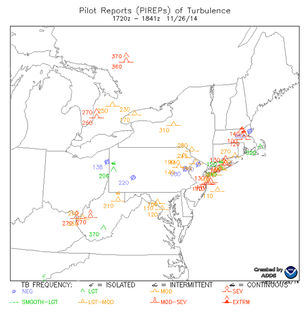
I won't try to decode this map for you, but it shows moderate to even severe turbulence from around Philadelphia across NYC and southern New England, including Boston. There is quite a bit of turbulence over the Appalachians, as well. If you are flying in these areas and are susceptible to air sickness, take your meds before you take off. Eat little.

Flying to/through O'Hare?

Image
AccuWeather regional radar at 12:45pm CST If you are flying through O'Hare later today or this evening, snow should not be a problem for airport operations. AccuWeather Enterprise Solutions provides precision forecasts to one of the most important airports in the world. H/T Chris Saindon. Flights to/from ORD in the last hour Because every client is different, we insure our team knows how to provide exactly the information each client needs, when they need it. Below is a photo of our team at the O'Hare control tower. This is typical of the "field trips" we take each year. Weather science has become a vital tool for the transportation industry and for many enterprises large and small. If you think you business could be more profitable with better use of weather information, give us a call. Just click on the orange link above.

12:45 CST Update: Weather Science is Really Getting Good at This!

Image
If you were reading this blog yesterday, you saw this forecast winterized radar for 1pm EST today. And, here is the actual (the color schemes are not the same) radar depiction of the precipitation at 1pm: Pretty amazing, I'd say. This blog, among many others, has been warning of today's snow storm since Saturday at 2:17pm… a full three days to adjust plans if you were so inclined.

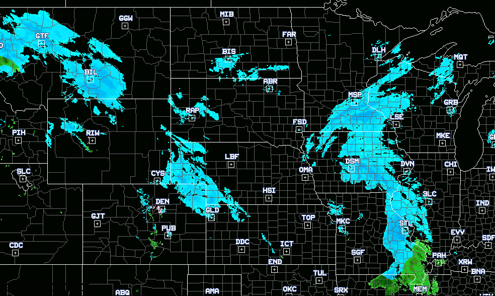
11:11am North Central Snow Update

Image
Image from northeast Colorado.

11am Winter Storm Update

Image
"Thundersnow" has been reported in Philadelphia and in several cities in Delaware. Lightning during a snow storm is just as dangerous as during the summer. Stay indoors! Current snow depth (via Twitter) in Sussex Co., NJ. Photo by "The Weatherboy." It is about an inch and a half. Just checked and all of the airports listed below still have major delays. AccuWeather is providing complete coverage of the storm. From the "Capital Weather Gang" here are some current snow amounts. A snow emergency has been declared in northwest and north central Maryland. Their coverage is here . Update at 12:20 p.m.:  A few of the higher snowfall totals through about 11 a.m. for some Eastern Seaboard locations: West Virginia Morgan County – 14 inches Hampshire County – 14 inches Hardy County — 13 inches Virginia Highland County — 5.5 inches Harrisonburg — 5 inches Frederick County – 1.6 inches Maryland Allegany County — 3 inches Pennsylvania

10am Travel Update

Image
Airport Delays Newark: 3 hr. 18 minutes LaGuardia 3 hr. 9 minutes Philadelphia  1 hr. 13 minutes JFK  15 minutes Minneapolis 1 hr. 23 minutes AccuWeather Regional Radar at 9:50am CST Just got an update, roads are "slushy" in Des Moines. The snow causing the delays in Minneapolis is visible.

8:45am CDT Travel Condition Update

Image
Airport Delays Newark  3 hr. 18 min. LaGuardia    3 hr. 9 min. Philadelphia 1 hr.  43 min.  Minneapolis 39 min. Reagan  15 min.  AccuWeather Regional Radar 9am addition: USA Today  reports 340 flights now cancelled. 

Storm Coverage Is Brought to You By...

Image
…the book that tells the deeply human story of how America's unique storm warning system was created and the people who created it. It is that storm warning system that is creating the forecasts you are seeing on this blog and elsewhere. If you enjoy this blog, you'll love Warnings! To be quite honest it is the best book I've read in years. I couldn't put it down and read the whole thing in a day and a half. I highly recommend it to anyone looking for an exciting book where you can learn something too.     ---- Elysium I'm an admitted severe weather geek, and so I read rabidly in this genre. Quality tends to be all over the place, but so far I've only read one book I couldn't finish because it was so poorly written (and it's hard to write so badly that it overshadows the cool factor of this subject). Still, it's something I'm always aware of, and so I had put Warnings on my holiday gift list instead of just going out and buying it. WHAT

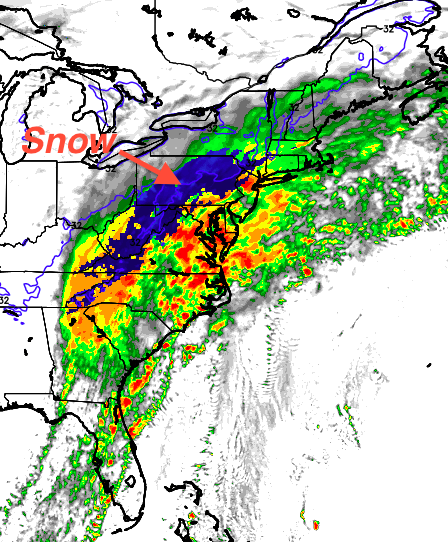
Eastern Storm Timing

Image
Here is the forecast radar for various times tomorrow. Blue shades are snow, darker = heavier. The small area of purple is sleet or mixed precipitation.  7am EST Wednesday 1pm Wednesday 6pm Wednesday NBC Nightly News  had a story about the family that rebooked the trip from Boston to Phoenix and left a day early and a second family that headed down I-95 to Florida a day early. Smart people!! Good luck tomorrow. I'll have additional updates in the morning.

Northern Rockies and Plains Storm

Image
Pink is a winter storm warning. Blue is a winter weather advisory. Green is a flood advisory. The browns are various high wind warnings and high wind advisories. Check AccuWeather for specific local forecasts.

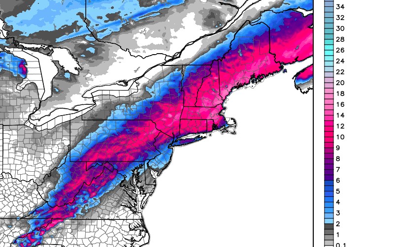
Winter Storm Update: 1:30pm CST

Image
Here is an overview of the storm total amount of snow expected. Note that amounts have gone up a bit in parts of New England. Here is the Boston-New York closeup. Note the extreme gradient between the coast (Logan Airport where 3-6" is expected) and areas farther inland and at higher elevations. Here is the Washington-Baltimore closeup. Reagan airport will have 2-4 inches with higher amounts at Dulles. Much farther south, these are the snowfall amounts expected to be on the ground at 9am EST Wednesday. I-40 will be a mess over the mountains. The storm will spread northeast during the day Wednesday. Again, my airline survival guide (free!) is here . If you can, take advantage of the waivers to beat the storm. UPDATE: 3:10PM. Here are the warnings issued by local NWS offices. Pink is a winter storm warning. The bluish is a winter weather advisory (a lesser condition) for lighter amounts of accumulating snow.

A Good California Soaking

Image
A rainy period will begin in far northern California on Saturday and will slowly spread south into the first of next week. This rain is desperately needed for the drought-weary state. Yes, it is possible there could be some travel issues late Sunday at SFO but it should not lead to widespread Thanksgiving travel issues.  The map depicts ten-day precipitation and is courtesy of Dr. Ryan Maue. 

Tuesday: 8:40am: Update on Travel Weather

Image
From AccuWeather … AccuWeather has a city-by-city summary and timing at the link. There is a second area of snow today that will move toward Chicago, causing flurries, tomorrow. AccuWeather has that story here .

More on Gov. Cuomo's Inaccurate Criticism of the National Weather Service

Another excellent article about New York Governor Cuomo's inaccurate and highly unfortunate criticism of the National Weather Service has been written. I'm running the article because what we are now forecasting -- pre-Thanksgiving snow as far south as North Carolina -- is also an unusual event and the article, hopefully, complements this blog's storm coverage. The article tells why  the Buffalo blizzard forecast was so difficult, so amazingly good, and why Gov. Cuomo is so far off base. Yesterday, on Twitter, I got quite a bit of criticism for linking the governor's comments to his belief in global warming. Perhaps I wasn't clear. Here is my logic: Politicians often hear the climate cult (NOT all climate scientists) constantly hyping "storms being made worse by global warming" even though there is little to no scientific evidence that is actually the case. So, we have a series of hugely inaccurate statements by senior officials: Gov. Cuomo telling Ne

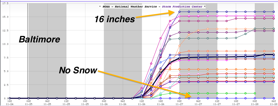
Why Human Meteorologists Are Still Needed

Image
If you were a resident of Baltimore and you received a forecast of snow accumulation between zero and sixteen inches you would laugh. Yet, that is the range of the latest set of computer models with regard to Wednesday's forecast snow. Meteorologists use their experience and know-how narrow down the alternatives and make useful forecasts. BTW, AccuWeather is forecasting only a coating to an inch or so in downtown Baltimore.