Wednesday, December 31, 2014

Dust Devil Outside the Rose Bowl Today


This is not a tornado, it is a dust devil without the dust (area is grassy or paved). Still, it causes quite a commotion.

PRELIMINARY Snow Path Forecast

Because there is so much travel after New Year's I want to post this very preliminary forecast of the path of accumulating snow. Please disregard the colors as I am not attempting to forecast amounts at this point. Also, please disregard the little kink in the path in central Kansas. I have added the orange dashed line to illustrate the northwest edge of the snow path.


Normally, I don't try to forecast a winter storm this far into the future, but I am doing this because I want travelers to be able to factor it into their plans.

AccuWeather is forecasting 3 to 6 inches for Wichita which seems reasonable as a preliminary amount.

ADDITION: Below is an update from AccuWeather on the ice in the southern Plains.

Fewer Tropical Storms: Another Thing to Be Thankful For

From Dr. Ryan Maue comes this graph of worldwide tropical storm frequency since 1976 when we first had worldwide satellite coverage. T.S. frequency peaked in the late '90's and has dropped every since to record low levels.

Remember, after Katrina, we were told how global warming was going to make hurricanes and tropical storms worse? Wrong again.

Winter in the Southern U.S.

Winter weather continues in the Southwest. AccuWeather has details.

Here is the current AccuWeather Regional Radar:
From Kingman, AZ an hour ago (photo via Twitter and @AlFinkbeier):

Over the weekend, the storm is forecast to move east.
Over central and West Texas, an icy mix of precipitation is forecast. Pink = winter storm warning. The blue is a winter weather advisory which is a lesser condition than a warning.

The question marks denote an area where snow is expected to develop on Saturday but locations and amounts are quite uncertain. I expect to be updating on the central Plains snow threat this afternoon.

Tuesday, December 30, 2014

Cold Storm, Far South

70 mph winds have blown over a semi in Davis County, Utah. 
And, it looks like the cold, wintery weather will spread east.
Pink is a winter storm warning. Blue is a winter weather advisory and green is a winter storm watch. The question marks are where snow may fall late Friday into late Saturday night.

Monday, December 29, 2014

Traveling I-70? Snow and Ice Between Denver and Goodland

Please allow extra time if you are traveling I-70 between Goodland, Kansas, and Denver, please be aware that accumulating snow, some freezing drizzle, and temperatures in the teens will make travel very slow and difficult.

Another New Review

The combination of a career autobiography and the evolution of the weather warning system makes this book unique and a fun read. It also answered the questions I used to ask as a child and totally forgot about until now. Who decided what color the weather is and how did they decide which colors to use? Mike Smith is incredibly talented and this book shows it. 

The book is available for purchase, here

Sunday, December 28, 2014

Facts and Falsehoods Regarding AirAsia Indonesia Missing Flight

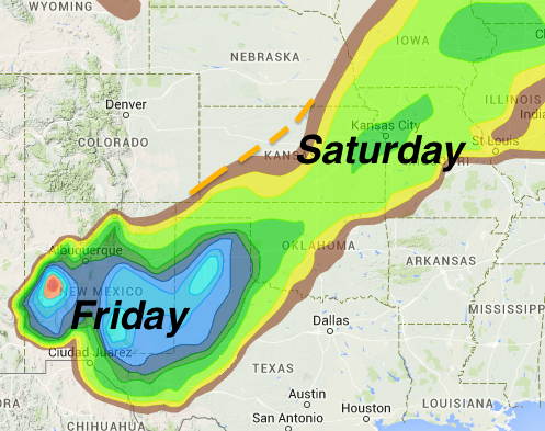
I have not followed this story to any degree. However, a news story I just read was so full of errors, I wanted to comment. These are technical comments for those interested.

There is no such thing as a "thunderstorm higher than 50,000 feet" (above sea level) that does not show up on ground-based weather radar, provided the storm is within range of the radar and the radar is properly calibrated. This nonsense about a "phantom" storm is just that, nonsense. However, weather radars are few and far between in that part of the world.

Second, there is no such thing as a thunderstorm, as described above, that does not show up on airborne weather radar, provided the radar is properly operated and calibrated. However, there are quite a few pilots who do not properly use airborne radar. They leave the radar's antenna tilt fixed (say, -2°) and never touch it. That can keep the radar's signal above the storm and the storm is never seen by the crew. That is different than saying the storm was not detectable by the radar.

With regard to air traffic control (ground-based) radar (ATC), a "primary" radar target -- in spite of what the name "primary" might suggest -- is not the "main" signal. A primary is simply the radar's signal bounding off an aircraft's skin. If the aircraft is equipped with a transponder, the ATC radar will show the name of the flight (i.e., "United Flight 802"), its altitude, etc. A "primary" signal is simply the aircraft's location and nothing else.

Hope all of this is helpful.

AccuWeather is covering the meteorological aspects of this story, here.

ADDITION: A pitot tube is not an air speed "indicator," it senses wind speed.

White Christmas in Hawaii

Meant to post this earlier in the week:
The two white spots are snow-covered Mauna Lea and Mauna Kea in Hawaii on Christmas Day.

Missing Airliner Story

AccuWeather is covering it here.

Sunday Essay: Richard Tol

Noted environmentalist provides a genuinely insightful look at global warming that balances the benefits and risks. Highly recommended. It is posted here.

Dr. Tol is hardly a climate skeptic which makes this essay all the more remarkable.

Saturday, December 27, 2014

Flood Danger Overnight

In the green areas:

The current AccuWeather Regional Radar shows heavy rain falling in many areas. Please do not try to cross flooded areas: Turn around, don't drown.

If You are Traveling Sunday

The Northwest is the only region with widespread winter weather conditions. Pinks = winter storm warning. Blues = winter weather advisory (a lesser condition than a warning). The hunter green in Colorado is a winter storm watch. The browns along I-80 in southeast Wyoming is a high wind warning.

Since This Is a Science Blog...

…I feel obliged to report that drinking seems to lead to a longer life. Study here.

While a glass of wine daily seems fine, I would be very surprised if three glasses every day leads to a longer life. In other words, don't take it too literally.

Thank You, Thank You

Just saw the BookScan sales numbers for week before last and Warnings did very well. Thanks very much. Hope all of you enjoy the book!

With Your Christmas Gift Card...

…a suggestion.
What do readers think of Warnings?
Your local bookstore has it or you can purchase it from Amazon or Barnes & Noble.

Friday, December 26, 2014

Global Warming: Is There Anything It Can't Do? XXXVIII

Another pint-sized 'study.' But, if you want to read the tiny details, go here.

Yes, It Is Available in eBook

Thanks so much to all of you who purchased Warnings as a Christmas gift. 

The ebook version of Warnings has 16 extra color photos that we could not get into the hardcover version. So, if you received a Kindle or Nook for Christmas and are looking for a great book, just click on the respective links.

This account of people who do something about the weather should appeal to just about anyone who enjoys talking about it.  -- Publisher's Weekly
To be quite honest it is the best book I've read in years. I couldn't put it down and read the whole thing in a day and a half. I highly recommend it to anyone looking for an exciting book where you can learn something too.  -- Elysium
While weather forecasters often appear starchy and bland, Smith makes the weather into an urgent concern, and a remarkable victory. This story turns the weather into a quest, and meteorologists into the most unlikely heroes in recent literature.  
                                                  -- University of Nebraska

And, we have a new review posted yesterday at Amazon:

Thursday, December 25, 2014

Tenth Anniversary of Boxing Day Tsunami

Friday is the tenth anniversary of the horrible Boxing Day Tsunami that killed hundreds of thousands in the Indian Ocean region in 2004. From Secretary of State, John Kerry:

I’ll never forget hearing the news of the tsunami that struck in the Indian Ocean 10 years ago. The images were gut-wrenching: entire towns razed from Indonesia to Somalia; raging waters sweeping away people’s homes; hundreds of thousands killed and many more separated from their families.

Today of all days, we pause to remember those we lost—from farmers and fishers to travelers from our own lands. I know that there are no words to express such a horrific loss. There’s no way to wipe away the pain of parents who lost a child, or children who lost their parents and were forced to assume adult responsibilities at a tender age.

We recognize the millions of people who contributed to the recovery effort. And we honor those who have continued to work in the years since to help the victims pick up the pieces and rebuild their communities. The tsunami was one of the worst we have ever seen, but it brought out the best in all of us.

It also sounded a warning. We know that many regions are already suffering historic floods and rising sea levels. And scientists have been saying for years that climate change could mean more frequent and disastrous storms, unless we stop and reverse course. Last year I visited the Philippines and saw the devastation of Typhoon Haiyan. It is incomprehensible that that kind of storm – or worse – could become the norm. The time to act on climate change is now – before it’s too late to heed the warning.

The first three paragraphs are well-done, obviously heartfelt and appreciated.

That said, there is no connection between global warming and tsunamis. It is true that sea levels are rising, but the rate of rise has been constant since the 1880's (most recent figures here).

The latest peer-reviewed literature says droughts and floods are not increasing. With regard to hurricanes, like Haiyan, they are not increasing! Above is a graph (arrow points to the Northern Hemisphere data for November, 2013, when Haiyan occurred) that shows hurricane activity peaked in 2005-2006 and has dropped since.

I wish the Secretary had not incorrectly conflated tsunamis with global warming because there is genuine good news on the topic of tsunamis. The National Oceanic and Atmospheric Administration (NOAA) has developed a greatly improved warning system for the United States and has worked with governments overseas to insure that even the people of less-well-off nations can be warned using this new technology. If you go to the link (blue, above), it will tell you about NOAA's excellent work in making us all safer.

Unfortunately, Weather Never Stops

I-80 is closed in Wyoming. Snow is falling over a good part of the Rocky Mountain region.
As much as 3" have already fallen in the Denver suburbs.

"Mixed Marriages"

In the 1950's and 60's, there were many great corporate rivalries far beyond what we have today in the likes of Microsoft and Apple. There was Hertz versus Avis. Kelloggs versus Post cereals.

One of the other great rivalries was Lionel electric trains versus American Flier. In that era, especially the 50's, an electric train was the ultimate Christmas gift. So, I thought I'd excerpt pieces of an article that appeared three days ago in the Wall Street Journal.


A New Yorker and a Midwesterner, a Polish Catholic and a Scots Presbyterian, an engineer and an English major—ours has been a marriage of opposites in many ways. With the approach of Christmas, I’m reminded of one more: American Flyer and Lionel.
I was the Lionel, and lacking any brothers, my sister and I knew that the train was really Dad’s. In real life he was an engineer (not the train kind), but to children, the difference between being an engineer and being the engineer of our in-house Lionel line for a time eluded us.
While some households set aside a dedicated area in the basement or attic for a permanent train layout, in our house The Train appeared only at Christmas. A sheet of plywood painted dark green with an improvised pipe-like Christmas-tree holder at its center was the Lionel’s home turf. For 11 months of the year the “train board” stood on edge at the side of our attic; then, sometime after Thanksgiving, living-room furniture would be shuffled and Dad would bring down the train board with its affixed oval track, then the boxes marked “Train,” signaling the beginning of the annual Lionel excitement, for Lionel could be a temperamental beast.
Our minimalist train setup only had one engine—a black steam-locomotive with delicate silver-colored handrails running its length and down to the cowcatcher, and silvery rods linking the driving wheels. The Lionel had a tender that I was told did something important with the electricity that drove the train, though I never understood what. And, as I suppose nearly everyone once knew, Lionel trains run on tracks having three parallel rails. Even as a small child, I found this detail an assault to my sense of verisimilitude. Everyone knows that any real train’s track has only two rails.
Eventually our father installed a pair of manually operated switches on one of the Lionel’s straightaways and a short siding for cars out of service, briefly rendering our railroading fantasy a bit more interesting. Nevertheless, the track on our green train board remained basically the unimaginative, optimally large oval that the rectangular board could accommodate.
The transformer with its control throttle was, without doubt, a hazard to life and property. Tiny wires wrapped in white, red and black insulation led from terminals on the track to the box, but the contacts got jostled and became incomplete (perhaps because of frequent train wrecks). I suspect that the transformer itself may even have been faulty, since I remember getting more than one electrical shock by touching it. Anyone who has run Lionels knows they have a unique smell, something like burning electricity, which very well may have been the case with ours. I well remember cautiously advancing the rheostat/throttle when I was finally allowed to “run the train,” knowing that the cantankerous Lionel could at any moment spurt forward and jump the tracks at the next corner—the ultimate humiliation.
Sometime while courting but before marriage, my husband and I happened upon the subject of model trains, though by that point in the relationship even the American Flyer/Lionel divide would not have derailed us. My disappointment lifted when I learned that my husband-to-be himself came from a mixed household. His father had first given an American Flyer to him and then later, wisely, gave his younger brother a Lionel, precluding disputes over rolling-stock ownership.  …
What happened to our old Lionel I have no idea, but on several Christmases my husband set up various American Flyer circuits from his train stash (for the children, of course) in our academic-gypsy homes in Austin, Texas, suburban Chicago and here in Durham, N.C. On living-room carpets, on attic floors, on platforms in basements, our kids politely played with the venerable American Flyers. Alas, neither child (even the one who became a mechanical engineer) eventually felt that model trains were competition for Pac-Man and his progeny.
Their father took it well. He packed away the American Flyer engines, cars and two-railed tracks, and during a downsizing we sent the trains to his brother. But now that our first grandson has been born, we are wondering if we downsized a little too much.
Yes, the "ozone" smell of a Lionel transformer. Wonderful memories.

At the Smith House, 2015 will be the "year of the train." Stay tuned. And, Merry Christmas.

Merry, Merry Christmas

On behalf of Forecaster Evie, Mindy and myself, please let us wish you and yours the merriest of Christmases.

Wednesday, December 24, 2014

Want to See Turbulence on Radar?

We are all used to looking at weather radar displays of reflectivity (radar's energy being scattered by precipitation) on television like the one below. It is of the Indianapolis NWS radar at 2pm EST.

Below is a radar image of a type you've never seen before. It is from the same radar using a type of data known as "spectrum width" which correlates well to turbulence aloft (the radar was pointed up when we grabbed this image). I've circled two areas of especially turbulent air.
Turbulence often takes a "wave" or banded form and you can certainly see that over southern Indiana with more diffuse turbulence over the northern part of the state. These images were from the same time and you can note that there is not much of a correlation between the turbulence and the intensity of the reflectivity data.

The turbulence data was captured from AccuWeather Enterprise Solutions' SmartWARN® system which is a workstation used exclusively by our meteorologists to create storm warnings and forecasts for our clients. It is much more sophisticated than any other meteorological workstation I have seen which partially accounts for the high level of accuracy in our storm warnings.

ADDITION: Confirming the disturbed air over the Hoosier State, at 2:08pm EST, a business jet urgently reported "moderate to severe chop" at 21,000 ft. south of Muncie, Indiana.
Posted on Twitter:

Turbulence Update

As of noon, the jet stream was located along the red arrows.
The clouds in the circled area reveal quite a bit of turbulence in their banded appearance. This is a typical situation when strong turbulence occurs. The jet will slowly move east through this evening.

With regard to the earlier turbulence forecast, the X symbols indicate where severe turbulence has been reported by commercial airliners (the last two from an Airbus 320 and a Boeing 737).

If you are planning to fly through the red circle,
  • Stay in your seat unless absolutely necessary.
  • In your seat, keep your seat belt on and pulled tight.
  • Do not eat a big meal immediately before boarding.
  • If you have airsickness medicine, take it before you board. 

Quick Travel Update

Tornado watch continues in the Southeast.

Widespread heavy rains in the East. Some rain now starting to change to snow in the Midwest. Radar at 12:20pm EST.

I wish to reiterate the importance of the high wind warning and watches (browns). In some spots, winds could gust to 50-60 mph later tonight and tomorrow causing power failures and downed tree limbs. Please be prepared. The blue is where the accumulating snow is still expected this afternoon and tonight. 
This will be the last Christmas Eve travel update. Hope they have been helpful. 

"Urgent - Severe Turbulence"

While I realize this is coded information, I want to make an important point:
It is a report of severe turbulence near Grand Rapids, Michigan from a regional jet that was sent with urgent priority.

Severe turbulence is rare. I am a very frequent flier and have experienced it exactly once (in a thunderstorm). If your flight is scheduled to fly through the oval I have drawn, please keep your seat belt tight, don't get up more than necessary and don't eat a big meal right before take off.

Addition: I plotted a map (courtesy, NWS Aviation Weather Center) of the current reports of turbulence and their short term forecast of moderate or greater turbulence (brown tint). The area of turbulence will expand and increase during the afternoon to, more or less, the red oval above.

Travel Condition Update

In the West:
Lots and lots of snow at higher elevations. Pink is for winter storm warnings. Blue is for a winter weather advisory. Gray is for dense fog. Dark green is a winter storm watch. Brown is a high wind warning.

In the South:
A tornado watch is in effect until 2pm.

For Chicago and surrounding areas:
The worst of the winter storm is forecast to just barely miss O'Hare with 1-2 inches of snow and Midway may have 1-3 inches. That will still cause delays this afternoon.

New England:
The purple is a freezing rain advisory. Green is flood advisories. Browns are high wind forecasts.

Airport Delays as of 8am CST

Philadelphia:   1 hour
San Francisco:   56 minutes
JFK:  15 minutes

Delays are forecast to increase as the day progresses.

Tuesday, December 23, 2014

Global Warming = Good. It's a Christmas Miracle!!


I never thought I would see this bit of honesty (good for him!) from Dr. John Holdren, the White House Science Advisor.

He tells us (jump to 1:06, if you wish) that global warming is saving us from a catastrophic ice age, a point many of us have made! Warming means longer growing seasons and more food for the billions of people on earth. With colder temperatures, we could not possibly grow enough food and famine would take the lives of millions. In addition, we would use much more energy and energy prices would soar. The poorest would suffer the most.

Thank you, Dr. Holdren, for your candor.

Now, let's get on with adapting to the comparatively minor (compared to an ice age) issues brought by a warming climate.

Waivers Issued for Winter Storm

Please click to see details. 
Although it is somewhat last minute, waivers have been issued. Above are United's. If you don't want to deal with a potential hassle of changing planes at Chicago, you have a couple of options:
  • Go through O'Hare or Midway before noon. The rain will change to snow midday and continue in the afternoon with high winds and limited visibility. 
  • Re-route to avoid Chicago. As I mentioned yesterday, instead of flying (United in this example) from Oklahoma to O'Hare to Grand Rapids fly Oklahoma City to Denver to Grand Rapids. Yes, it is more miles but the weather in Denver will be good and you should fly over the storm. 
There is much more information at the red link above. The weather forecast is here

Southeast Storm Summary

As of 4:20pm CST. Bright red = tornado warnings. Maroon = flash flood warnings. Amber = severe thunderstorm warnings for damaging winds. Green = flash flood watch. Please continue to monitor local warning sources. 

In addition to the tornado threat, I am very concerned about flash flooding as darkness falls. Some areas of southeast Alabama and western Georgia may have a storm total rainfall of 10 inches or more. Do not drive into flooded areas, turn around, don't drown!

Photos of the Long-Track Tornado

Near Columbia, MS via Twitter and "Fire the Union Thugs" (sorry for the name).
There are reports of people trapped in homes in the Columbia area.

The same tornado, farther northeast, northwest of Ellsville, MS. via Jacob DeFinch and Twitter.

Tornado watches continue (scroll down). Please closely monitor the weather if you live in these areas.

Tornado Watch for Alabama and Florida

Several damaging tornadoes have already occurred today. This new tornado watch is in effect until 11pm CST.
Please monitor local weather warnings in these areas.

Earlier today:

Via Twitter and Andy Cunningham. North shore area north of New Orleans.


Via Twitter and Tangipahoa Parish (LA) government.

Confirmed Tornado Near Columbia, MS

2:41pm. Tornado near Sumrall, MS. 


2:38pm update. Tornado at arrow at that time moving NE at 45 mph.
Hattiesburg circled for reference.
Take cover if you are in the red polygon. Damage confirmed. 


-Original Posting-
Doppler wind display from 2:23pm, the tornado is moving northeast. Damage is confirmed.

Tornado threat will likely extend farther east where a tornado watch will likely be issued (red outline).