Posts

Showing posts from February, 2020

Looking for a Getaway? Try Wichita

Image
The Keeper of the Plains - Symbol of Wichita Try Wichita. You will be pleasantly surprised as Midwest Living  explains.

Another Serious Flooding Threat in the Southeast and Tennessee Valley

Image
The gold is an area of 7"+ over far south Kentucky and Tennessee. Late data indicates that as much as 10 inches of rain may fall in Tennessee over the next seven days. Please prepare accordingly.

Tune in Today's "What the Weather" Podcast

Image
I had the pleasure of appearing on the What the Weather  podcast today. Our focus was on tornadoes but there were many other topics covered.  The time just flew by and I hope you enjoy listening as much as Shawna, Jon, James and I had producing it. You can listen to it by clicking here . Scroll to the bottom of the page and you are all set.

Wellsville is Very Early or Very Late

Image
[So is the Wall Street Journal, see below] Taken less than one hour ago. Addition, Saturday, 5pm Winter stew recipe on February 29? Either very early or very late. 

The CDC Has Been Off-Mission For Years

Image
[see update at bottom] There are many this morning offering stinging criticism of the Centers for Disease Control's (CDC) lack of preparedness for the coronavirus. They don't even have test kits ready. Some are calling for importing Europe's test kits. One of dozens of articles and tweets criticizing the CDC this morning So, what has the CDC been doing? How about tornado warnings and lightning studies? This blog has been covering CDC's off-mission activities for years. Below is just one of many examples. During the same period of time, the CDC was mishandling dangerous biological materials. click to enlarge I'm always surprised that people assume government agencies are competent. Some are (the National Weather Service) and some are not (the TSA). The signals that there is something wrong with the CDC have been present for years. President Trump, are you paying attention? Update: 8:30pm, USA Today  has re-published a very similar column this evening

Another Great Rating For "Warnings"

Image
If you want a great book for a late winter or spring getaway, it is available here .

Rest in Peace, Jeff Kimpel

Image
It is with great sadness that I learned this morning about the passing of Dr. Jeff Kimpel. Jeff had an extraordinary career in meteorology that began while serving in Vietnam for the Air Force. Jeff finished his PhD at the University of Wisconsin and moved to the University of Oklahoma. I walked into stinky Felgar Hall at OU at the start of my junior year and there was Jeff sitting in the office previously occupied by my advisor. I learned that I had been assigned to Jeff for my junior and senior years. That began an amazing relationship that lasted until his retirement from Director of the National Severe Storms Laboratory. Jeff was: Head of the Department of Meteorology at OU. OU's Provost Oversaw the NWS Storm Prediction Center Was the third Director of the National Severe Storms Laboratory Rest in peace, Jeff!!

Winter Storm on Course

Image
As of 9am, here is the latest winter weather information from the National Weather Service. As expected a narrow band of extreme heavy snow developed in central Kansas. As much as 6 to 9 inches have fallen in the pink counties with snow still falling. Here is the radar as of 9:15. The snow over the Great Plains is moving south while the snow  developing over Missouri and Iowa is nearly stationary for the moment.

No One Cares About Global Warming

As an atmospheric scientist, I have many friends who are scientists focused on global warming. I will often write and say, "no one cares about global warming." They don't believe it. This summary of Pew Research polls will confirm that few care about the issue.

6:45pm Monday: Major Winter Storm Developing

Image
These snowfall amounts, from AccuWeather, look reasonable to me. Major snows are expected in both Chicagoland (especially in the southern suburbs) and Detroit (especially in the northern suburbs). The snow should begin in Quincy around 8am and Chicago around midday. Meanwhile, farther west, rare snow squall warnings are in effect in southwest Kansas. Winds are gusting to 40 mph with very low visibility in heavy snow. This map, which shows forecast snow through 7pm Tuesday, shows the start of the Midwest winter storm in Missouri and Illinois. Farther west, across Kansas and Nebraska, snow is forecast to forecast in higher amounts than we thought 24 hours ago. Please note that some quick accumulations of several inches (even more in the center of Kansas) may occur tonight through Tuesday evening. In Wichita, I wouldn't be surprised to receive 1-4 inches of snow.

Important Rains For the 2020 Winter Wheat Crop

Image
Soaking rains fell over most of the primary winter wheat areas of Kansas and far northern Oklahoma during the last 48 hours ending at 11am. The wheat, at this point, should be very good shape as Kansas has avoided extreme cold this winter and precipitation has been timely and plentiful. You may click on the map to enlarge.

Winter Storm For the Midwest and Great Lakes

Image
I'm surprised that winter storm watches and warnings are not already out; but here is a map from AccuWeather that shows the timing of a signifiant winter storm that will develop tonight. This is a first approximation of snowfalls with this storm.

Katherine Johnson, Rest in Peace

Image
The great Katherine Johnson passed away at the age of 102 this morning. She gained long overdue fame from the movie Hidden Figures  but did so much more in her life. Katherine was one of three black girls to integrate West Virginia's schools and set academic records. In 1952, she learned about what would become NASA. Her full biography is here . In 2015, at age 97, President Obama awarded her the Presidential Medal of Freedom. She lived a full, wonderful life. Rest in pace, Katherine!

Agree With This 100%

Image
This was recently sent to me. Agree 100%. 

Sunday Fun: Ultimate "Guy" Video

Image
World's Longest Home Run 

After 9 Years, Tornado Tracks Still Visible

Image
click to enlarge Even though it will be nine full years on April 26, two of the tracks of the violent tornadoes in Alabama are still visible from space. The first is the Tuscaloosa (TCL) to Birmingham (BHM) track. The second, at upper left, is the Reform to Cordova tornado track. That these tracks are still visible is testament to the violence of the storms that day, April 26, 2011. Hat tip: Kevin Scharfenberg

NWS Takes a Half-Step Toward Better Atmospheric Modeling

Image
Sunday, I wrote about issues facing the National Weather Service pertaining to its computer modeling .  Today, the NWS announced it is going to triple its computing capability. However, that increase is less than a third of what has been recommended . But, my concern is they have the cart before the horse. Before buying new computer power, however welcome that is, they should have decided what is the future of their modeling program. In other words, what type of models do they wish to run?   That is still very much up in the air. NOAA's modeling has two other major issues: The headquarters models treat atmospheric modeling primarily as a physics challenge rather than as furnishing great guidance to the forecasting community. Their recent switch to the FV3 was not an guidance improvement but the modelers thought it was a more modern model. Poor reasoning.  The speed of the models count. There are demands on mesoscale modeling to handle tornadoes, flash floods, ice storms,

A Most Welcome Improvement to the NWS/FCC's WEA Warning System

Image
With numerous good reasons on multiple occasions, I have been very critical of the WEA smartphone storm warning system. My most recent posting was in August . WEA is a program of the National Weather Service (NWS) and Federal Communications Commission (FCC). My primary objections is that it duplicates free services already available that are much more location-specific. As the August article demonstrated, the false alarm rate with the WEA alerts are huge. I am happy to report they are making one improvement that I really like . The NWS is going to categorize flash flood warnings by severity and only the top two levels will trigger WEA. That will cut down on the high level of unnecessary false alarms such as the one August 8, 2019, in south central Kansas. Good job, NWS and FCC. There are rumors floating around that they are going to add severe thunderstorm warnings to the WEA alerts. That is a terrible idea and it will kill WEA just like the severe thunderstorm warnings have

9:45am Wednesday Snow Update

Image
Forecast hasn't changed much (see below). Note the small dot of 4" amounts near Dodge City. It could be a bit farther east based on some late data. Denver will receive 1-2" and Wichita 1 to 3 inches. Radar 9:38am.

Some Housekeeping....

....this blog is Copyright 2020, Mike Smith Enterprises, LLC. The photos are my own, licensed from iStock photos, or (with credit) third parties under Fair Use for news. Those are credited to the photographer.

Snow: Front Range to Central Plains

Image
Above is AccuWeather's forecast for the next weather system to affect the central United States. There could be some isolated 3 inch amounts perhaps as far east as Hays or LaCrosse, Kansas. For my readers in the Wichita area, I'm expecting 1 to 2 inches.

Yes, Prudent Planning is Vital

Image
I agree with the sentiment expressed in this Wall Street Journal  headline: I also contend that, with the 2020 tornado and then hurricane seasons rapidly approaching, it is important to also plan for emergencies. Warnings  tells the upbeat, true story of how the tornado and hurricane warning systems came to be and the people who built them. When the Sirens Were Silent  is the story of how the warning system failed the people of Joplin, resulting in 161 deaths. It also tells how you can protect yourself whether at home, at work or at school.

Sunday Feature: The Best Christmas Story You Never Heard

Image
An amazing story of the 2020 Army-Navy game and a salute to our nation's injured military. Details are here. A brief, highly recommended read . Hat Tip: Trainorders.com

You Mean We Did It Without the Paris Accords?

Image
The free market, as opposed to government, is the solution to global warming.

Way to Go, Bernie!

Image
Daily Mail There are postings all over Twitter giving Sander's a hard time because he was flying first class. I completely disagree and actually salute him. Whether you agree with his politics or not (in my case, not!), running for President is grueling. Grueling! He deserves the extra room. Plus, he was on a small jet so he could have a seat by himself. Given that he has to deal with strangers throughout almost every day of the campaign so his motivation to fly first class was probably to have a few minutes to himself as much as anything. But, most importantly, he is walking is own walk. By flying commercial, he is putting little additional CO2 into the atmosphere as opposed to flying private.  Congratulations, Bernie.

Another New Rating of "Warnings"

Image
Yet another happy reader. Thank you, David. If you would like a great read for a winter getaway, click here .

Jim Williams, Rest in Peace

Image
Jim Williams, one of my mentors, has passed away at the age of 91. His full obituary is here . Jim served the people of Oklahoma with groundbreaking weather coverage for 32 years. WKY TV (now KFOR) was the #1 television station in the Oklahoma City market in 1971. WKY was the organization that invented tornado warnings and it had an outstanding reputation for severe weather coverage -- thanks in large part to Jim. He received an award for outstanding severe weather coverage from the American Meteorological Society. In '71, while a meteorology student at the University of Oklahoma, I heard WKY was looking for a part-time meteorologist. Since almost all meteorologists want full-time work, I thought there was a slight chance they might consider hiring me. Unbelievably, even though I was only 19, Jim took that chance. His kindness led to a television career that lasted until 1993 when I took myself off the air to run WeatherData, Inc., the company I had founded, full-time. Mik

Global Warming and Sea Level Rise

Image
Dr. Judith Curry has published an important paper contributing to the knowledge base pertaining to sea level rise and global warming. The full paper is   here . There are a few highlights I wish to mention: Some of the global warming activists would have you believe that sea level has been more or less constant over the eons. This, of course, is not correct. As Hubert Lamb (source of the quote, above, which appears in Dr. Curry's paper) points out, sea level has varied considerably during the last 4,000 years. The conclusions begin on page 69 and they are well worth reading (non-technical). The bottom line is, "Recent research has concluded that there is no consistent or compelling evidence that recent rates of sea level rise are higher or abnormal in the context of the historical records back to the 19th century that are available across Europe." Europe, in this case, is a rough proxy for world sea level. Of course, it is fair to point out that 500 years ago we

Pro Tip: Weather Forecasting Without Models

Image
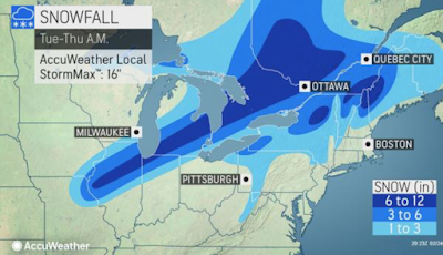
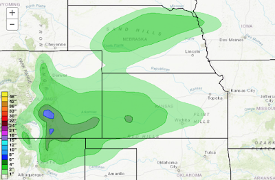
-- For Meteorologists -- There are some tweets this afternoon that have said, "the accumulating snow is ending for Wichita" or words to that effect. And, the radar was fairly clear to the west southwest.  Radar at 12:10p But, pattern recognition,  an important forecasting tool independent of the models, indicates otherwise. In this type of storm, a final snow band usually forms along the 500mb trough line. Here is the trough line at 1pm. In addition, the infrared satellite shows multi-layered clouds (capable of producing accumulating snow) west to the trough line.  As long as multi-layered clouds are present, accumulating snow (given cold enough surface temperatures) is possible.  In this part of the county, the snow band associated with the trough line will often produce 1/2" to 1 inch of additional snow.  And, sure enough, as of 1:40pm CST, snow is redeveloping on radar to the west of Wichita (compare this image to the one at the top). 

Ha, Ha, Ha, Ha, Ha, Ha, Ha, Ha

Image
I'll believe global warming is a problem when the people who tell me it's a problem start acting like its a problem.   --  Dr. Glenn Reynolds Actually, "just talking" is a perfect description of Mr. Bloomberg on the topic of global warming. Mr. Bloomberg has a fleet  of private jets and helicopters. NY Daily News NY Intelligencer Not only does he produce massive amounts of carbon flying by flying privately everywhere (he even once tried to use his helicopter to fly to a sports stadium to watch a game), he has 13  homes around the world! In Mr. Bloomberg's reality: you and I should sacrifice and cut our already modest carbon footprints so the elite, with carbon footprints the size of Asia, can continue their jet-set lifestyles. What a (really bad) joke!

Today's Tornado Risk

Image
There is a risk of tornadoes later today in the area in brown. Please keep up on the weather in this region.

Winter Weather Mess

Image
Orange = blizzard warning. Pink = winter storm warning. Purple = winter weather travel advisory Greens = various flood warnings.