Posts

Showing posts from September, 2015

Special Hurricane Joaquin Update

Image
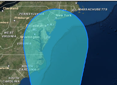
Wind speeds are now at 105 mph and pressure is down to 954 mb. Satellite images show an eye (yellow dot) forming and a stronger central dense overcast, always a sign of strengthening. The computer models that have come in since I last posted have allowed me to become a bit more confident as to the location of landfall (between the orange lines). It now seems likely Joaquin will reach at least Category 3 (major) status and Cat. 4 is not out of the question.  So, now is the time to start thinking about hurricane precautions (flood precautions are below, scroll down) if you are along or east of I-95 in Virginia/North Carolina: Bring in lawn furniture, trampolines and other items that might blow about. Any car not needed for evacuation needs to be in the garage or other shelter. Get plenty of cash -- twice what you think you will need -- as if you will be gone for two weeks. If the power failures, your credit card will not work. Cash is king.  Prescriptions should be refilled.

Hurricane Joaquin Has Rapidly Strengthened

Winds now 105 mph as of 8pm EDT.

Hurricane Joaquin's Serious to Catastrophic Flooding to Cost Economy Billions

 Tropical Storm Joaquin was upgraded to a Category 1 Hurricane this morning hitting sustained winds of 75 mph and promises to be a knockout, even if it never makes landfall. Projections are that it could dump up to 10 inches of rain over parts of the country from the southeast to New England, and is threatening to cost the US economy billions. Adding to the worries, Joaquin could converge with another slow-moving storm on the East Coast and lead to devastating flooding into next week. Mike was quoted today in Fortune saying that this storm has one of the most alarming rainfall forecasts he has seen, with the potential of serious catastrophic flooding from North Carolina to Massachusetts. It will also disrupt the economy with the economic impact reaching into the billions of dollars from damaged property, disruption in manufacturing, shipping companies having trouble making deliveries, cancelled flights, and preventing people from going out for shopping, dinning and entertainment t

Hurricane Joaquin + Major Flooding Possible

Image
I try not to write to much "inside meteorology"on this blog since it is for the public-at-large. However, meteorologists are dealing with an extraordinary situation this evening so I hope a little "insider" information might be interesting. Normally, at this point in a major tropical weather system, the "models" (computer simulations of the future state of the atmosphere) start coming together geographically. Today, they are doing anything but converging with regard to Hurricane Joaquin. Courtesy of Dr. Ryan Maue, here is a plot of all of the different model solutions. It is breathtaking in its breadth. Nevertheless, meteorologists don't get to say, "the models were bad" as an excuse. You expect us to give us our best forecast regardless of any problems we may have to face. So, here goes: Flooding This is a huge issue. As much as 14" inches of rain have fallen in western Virginia in the past seven days (see map below). The red

Unprecedented Rain Forecast

Image
This is one of the most alarming rainfall forecasts I have ever seen. Regardless of what Hurricane Joaquin may do (see below), this forecast requires preparation, especially in the amber (>7") areas. If this forecast is correct, the resulting flooding will last more than a week and  will likely overwhelm FEMA and other assistance agencies. So, you will need to plan for yourself and your family.  Here are preparation suggestions: Plenty of extra cash. A full tank of fuel for your vehicle. Freshly refilled prescriptions. Valuables gathered together so they can be quickly put into the trunk so you can leave quickly. A place to go:  A relative's home on high ground, a motel, a public shelter, etc. If you go to a hotel, have a reservation. You may wish to consider an "extended stay" type of hotel. Be prepared to put valuable items you cannot take with you on top of tables, on the second floor, or in the attic to hopefully protect them from floodwaters.  If

Joaquin: Last Update of the Evening

Image
Here is the 8:15pm satellite image of Joaquin. I believe the storm has reached hurricane intensity and will be officially upgraded to a hurricane in the National Hurricane Center's 11pm advisory. The storm is drifting slowly west. It continues to be a threat to the U.S. The flood threat (scroll down and look at postings since noon today) has, if anything, increased based on the data that has come in since I wrote those postings. There is the potential for catastrophic flooding in the Middle Atlantic region.  I will be updating the blog tomorrow with later forecasts and analysis. Please suggest it to your friends who live in the Middle Atlantic and Northeast regions of the country. Here are some preliminary preparation ideas: Plenty of extra cash. A full tank of fuel for your vehicle. Freshly refilled prescriptions. Valuables gathered together so they can be quickly put into the trunk so you can leave quickly. A place to go:  A relative's home on high ground, a mo

Do You Realize That At This Very Moment...

….the expensive public relations companies employed by Big Climate are working overtime to create a variety of press releases so that, no matter where, when or how hard Joaquin hits, it will be blamed on 'climate change'?

Joaquin: Additional Weather Balloons to Be Lauched

Image
Essentially, from the Mississippi River, east the NWS is going to launch weather balloons at 6-hour rather than 12-hour intervals. They did this in the run-up to Sandy and it worked well. Given that T.S. Joaquin is very near hurricane strength and strengthening, it is important to have this data to forecast the track of the (soon to be) hurricane and  the very heavy rain forecast for the East Coast region. Addition: Here is a map showing the weather stations that will be launching the additional balloons.

Another Rainfall Opinion

Image
Here is the National Weather Service's 7-Day rainfall forecast: They are forecasting lower localized totals but an event that is much broader geographically. Either forecast will cause widespread, serious flooding.  Since tonight's model runs will have the additional data from the Hurricane Hunters, I will try to focus in on the threat area with tomorrow morning's blog postings.

The Latest East Coast Weather Update

Image
I'm confident a heavy rain pattern will set up over the East that will result in flooding. Unfortunately, is about all I am confident of at this moment. Let's break down what I know and my forecasting experience indicates. Tropical Storm Joaquin The storm, based on satellite imagery, seems to be intensifying east of the Bahamas. The satellite image from below is from 2:15pm EDT. The storm will likely drift west for another 12-18 hours, then begin to make a turn to the north. I am not  confident as to whether it will make landfall over the Northeast or stay out to sea.  It will also intensify further and may make hurricane status. We should have a much better idea late tonight and tomorrow morning as the Hurricane Hunters are just starting to investigate this storm. It will take a few hours to gather the data then about 10-12 hours for all of the computer models to make their forecasts. Heavy Rain Events There will be two periods of heavy rain between now and Monday

Serious Flooding Risk in the Northeast

Image
I continue to be quite concerned about the flooding risk in the Northeast. If you live in a low-lying or flood prone area, now  is the time to consider what you would need to take if you are forced to move to higher ground. It wouldn't hurt to get some extra cash and make sure your car has plenty of fuel.

Tropical Storm Joaquin Has Formed

Image
If you live in the area outlined, I strongly suggest you keep an eye on the weather later in the week. High winds and torrential, likely flood-producing in places, rains are quite likely in some of these areas In addition, there is a risk the storm could reach hurricane intensity but that is still speculative. Stay tuned.

Genuinely Incredible Volcano Video!

Super-charged volcanic ash cloud sparked with lightning in Pat... Be amazed by a super-charged volcanic ash cloud sparked by lightning.#PATAGONIA Posted by BBC Earth on Monday, September 28, 2015

Traveling to the Northeast End of Week?

If so, please keep an eye on the weather. From Philadelphia to Boston it looks like there will be very heavy rain with the potential for flooding along with high winds. Stay tuned….

American Meteorological Society Award Winners for 2016

Image
The list of winners is up and available here . I wish to make special note of AccuWeather's Mike Sternberg who has won the prestigious Award for Outstanding Contribution to the Advance of Applied Meteorology. The recipient of this award is in rare company: Dr. Ted Fujita, Col. Robert Miller (first tornado forecast) and Dr. Paul MacCready (first human-powered aircraft to cross the English Channel). Congratulations to all!!

Dangerous Aspect to Building Boom in Hurricane Alley?

Image
There is a fascinating study in 538  where author Matt Lanza asks what happens when the (amazing) ten year drought of major hurricanes to hit the United States ends. But there’s a downside to those years of good weather. While the big storms have stayed away, the coastal population in the U.S. has continued to increase, and in a few cases it has been surging. When a major hurricane next strikes — and it will — it will very likely hit an area that is even more vulnerable to destruction, with a large group of new residents who might have no experience with extremes of high winds and water. I moved to Houston in 2012, one of more than 800,000 people to do so since 2008, 2  when Hurricane Ike hit the area. According to the  Houston-Galveston Area Council , the population of that eight-county area is expected to grow more than 40 percent through 2040 to more than 10 million people. A list published by the  Greater Baton Rouge Industry Alliance  earlier this year showed more than $100

Sunday Fun: Colbert

Image
[Editorial note, I am Catholic] Stephen Colbert (also Catholic) on Thursday night's Late Show after the Pope had his Vespers service at St. Patrick's Cathedral, Pope Francis is in America. There is an excitement in the air that America's seventy million Catholics  don't normally have unless we are asking forgiveness for it afterwards.  Referring to the Pope's vestments, Colbert also commented, I hope Francis doesn't have any trouble leaving town. The flowing robes and Papal headgear are 'TSA Bait.'

Downburst #2

Image
Downbursts usually occur in " families " and that is the case this evening as a second distinct downburst (at this point, a "microburst") has occurred from a second thunderstorm that formed on the original downburst's gust front (scroll down). Here is the Doppler wind data as of 6:10pm. The original downburst's winds are the thicker arrows. The second downburst, to the northeast, is shown by the thinner arrows. Here is the latest reflectivity data at 6:18pm. You can see the second thunderstorm south of Haysville which caused the second microburst.

Classic Downburst South of Wichita

Image
An absolutely classic downburst is shown by the Doppler wind data south of Wichita. At 5:44pm, you see the green winds blowing toward the radar (~35-40 mph) and red winds blowing away from the radar. The "zot" symbols are cloud-to-ground lightning locations. It is common for lightning to flow from the thunderstorm to the ground in the downburst's rain shaft. There is another sign of the downburst in the reflectivity data (the type you see on TV).The thin, circular line is called a "gust front" by meteorologists. The reason the thunderstorm is not in the center of the ring is because it has been moving southeast during the few minutes since the downburst first hit the ground. These are the types of storms that used to cause horrific airliner crashes. However, through the work of weather science , more than a thousand lives and literally billions of dollars have been saved. 

The Real Global Warming Conspiracy

We keep hearing about the non-existent conspiracy among the people who doubt that global warming will be a catastrophic issue, a topic I've written about a number of times (as recently as last week ). It appears the conspiracy crowd is simply engaged in projection. Investor's Business Daily  has an alarming report pertaining to how Big Climate links together to influence both units of state and federal government.

Another Five Star Review

Image
Another 5-Star review by an Amazon reader : Superb! By Pangur Ban on September 22, 2015 Format: Kindle Edition Verified Purchase This book is a great teaching tool. One can learn much about the history of severe weather prediction, including the technological developments, the reporting progression, and the understanding of severe weather. Though I grew up in Tornado Alley, I learned much about tornadoes I had not known. The photos were of great help in visualizing the concepts or events being described. Well done! Reader after reader rates Warnings  with the highest rating. Pick up a copy…you'll really enjoy it!

Ever Notice How the People Who Claim to Be Most Concerned About Global Warming Never Act in Accord With Their Concern?

Image
Details here .

Americans Love the Pope; His Global Warming Stance? Not So Much

Pollster J. Ann Selzer has an interesting poll out this morning pertaining to how Americans view Pope Francis . His position on global warming is particularly unpopular, which doesn't surprise me.

Calm Weather Across the Contiguous United States

Image
Things are pretty calm these days.

Heavy Rains in Arizona

Image
Here is the radar as of 1:30pm Arizona time showing that heavy rains have developed as forecast. Areas of flooding are likely.  Remember: Turn around, don't drown.

Flash Flood Risk in Arizona

Image
More than four inches of rain are forecast to fall in parts of Arizona the next few days. Please be aware of the risk of flash floods and turn around, don't drown. 

Sunday Fun: Christmas Trains

Image
The photo above is some of my trains whizzing around a Christmas train layout at Towne West Square in Wichita. Why am I bringing this up in September? There are a lot of train clubs around the nation and there are a lot of empty spaces in malls these days. It has been found that a well-publicized train layout brings people into the mall and brings new members to the train club. Some even have a voluntary donation can for the train club, so it can be a source of revenue. But, all of this works only if there are enough volunteers. So, if running trains in front of adoring children sounds like fun, you may wish to contact your local train club now, in plenty of time before the rush.

Environmental Catch-22

An essay well worth reading.

Scientists as Advocates: A Disgraceful Letter

Image
It just came to my attention that a number of people who call themselves climate scientists have called for a criminal  (i.e, people go to jail) probe of those who do not believe global warming is an urgent crisis. Their disgusting letter to President Obama is here . This isn't science, it raw advocacy in its most dirty form. Their 'evidence' of what they call a "conspiracy" are a number of reports by the same people that quote the same old canards, many of which are more than 15-years old . Because it is their most recent 'evidence,' I read the entire Union of Concerned Scientists' (UCS) report which is here . With one exception, their evidence is a complete joke. The fact that a conservative group funded research is no more evidence of a conspiracy than, for example, World Wildlife Fund funding research. Most of UCS's allegations involve activities of more than a dozen years ago: Three 1998's and one 2002. This is typical throughout

What the Pope Eats: 'I Am Watching'

Image
The global warming crowd gets nuttier by the day. Here's the latest: For some reason USA Today  gave valuable newspaper space to someone named Bruce Friedrich of something called Farm Sanctuary to tell us "[he] is watching" to see whether the Pope eats meat when he is in the United States because of -- you guessed it -- global warming. As a practicing Catholic, I can confidently inform Mr. Friedrich that there is nothing  in Catholic doctrine or teaching that forbids the consumption of meat except on Ash Wednesday and Good Friday.

National Weather Festival- October 31, 2015

 The 2015 National Weather Festival will be held on the Oklahoma University campus on Saturday, October 31, 2015 from 10:00 a.m. to 2:00 p.m. The festival will feature all things weather related, including information to keep you safe and products to protect your home. The festival event will also showcase children's activities, weather superheros, local TV meteorologists and storm chasing vehicles. The sponsor for the event is the National Weather Center, 120 David L. Boren Blvd, Norman, Oklahoma 73072. National Weather Festival- October 31, 2015

Thursday Fun: For Me, This is Dangerous

Image
Normally, we do our light-hearted postings on Thursdays but I wanted readers to see this announcement. For $100, you get seven weeks of unlimited pasta . Mamma Mia that's a spicy offer!

Tsunami Watch for Hawaii

After the Chilean earthquake, a tsunami has struck their coast. The U.S. National Weather Service has issued a tsunami watch  for Hawaii. A watch means to make preliminary preparations and listen for an all-clear or an upgrade to a warning which means to move to higher ground. I am not  live-blogging this but I want my readers to make sure that their friends and relatives are aware.

El Dorado Rotary - November 4, 2015

Mike Smith will be speaking at the El Dorado Rotary Club on Wednesday, November 4, 2015 where he will be sharing his presentation CSI: Meteorology with the audience. His presentation highlights the discovery of the microburst which was responsible for bringing down so many commercial jets in the 1970's, 80's and early 90's. Mike and his friend and mentor, the late Dr. Ted Fujita, worked behind the scenes and have made everyone who flies today much safer. If your business, club or organization is interested in having Mike speak at a future event, please contact me at mindy@mikesmithenterprises.com .

Fewer Hurricanes to Threaten the United States?

Perhaps some good news .

Green Energy: Some Encouraging News

I have said many times that I would be fine with renewable energy if some its inherent issues could be solved. One of them, on which I have posted in detail twice, is the inability of the electrical grid to handle more than a trivial amount of "green" energy. Now, that limitation is being challenged by both experience in California and some new technology: Today, California often gets as much as 30% of its power from renewables; there are periods of the day when production can soar to 40%. California legislators just approved a plan that would require half of all power to come from renewables by 2030. Still, the tipping point the power industry feared hasn’t materialized. So, here is the other side of the story . I hope they are correct. Time will tell.

Sunday Fun: "Jersey Boys" by the U.S. Navy

Image
Courtesy of Dennis Cross (Forecaster Evie's other grandfather and a proud Navy vet) here is an excellent version of several Four Seasons' songs performed Jersey Boys  style. Enjoy!

Yet Another Climate Science Fiasco

One of the theories of global warming is that the polar regions will warm faster than the tropics. If that is true (I think it is questionable), the "temperature gradient" will weaken which means, in general, less wind. We learned about the temperature gradient and its relation to wind in Meteorology 101 (really). Apparently, Big Wind and its goal to fight global warming never considered this conundrum. So, even though there are more wind wind turbines than last year, wind energy production is down 6%  when compared to the same time last year. Sheesh.  [link fixed, sorry]

Great News: National Weather Service Licenses AccuWeather Patents

Very pleased to announce that the NOAA National Weather Service has licensed patent technology from AccuWeather. "The National Weather Service and AccuWeather have worked closely together to ensure the safety of businesses and individuals across the United States, helping citizens to become better prepared for severe weather," said Barry Lee Myers, CEO of AccuWeather. "We are proud to be at the forefront of this ground-breaking government and weather industry partnership and thank our colleagues at the NWS for their diligence and dedication, joining together to bring the advantage of AccuWeather's proprietary technologies forward to improve people's lives." Myers added, "The license value of AccuWeather's technology patents is worth upwards of seven figures per license, but AccuWeather provided this license to the NWS at no cost, as a public service." The full details are here .

Central Plains Tornado Risk

Image
There is a risk of tornadoes later today in a small area of the central Plains. I recommend keeping an eye on the weather in this region.

Want an Interesting Read?

Image
Want a great book ? Even though it sounds like a boring topic, it is very interesting and and a fresh idea for a biography. Highly recommended. Hat tip: David Ford

Tornado in Turkey

Image
With the refugee crisis, this is the last thing the nation of Turkey needed. I was surprised to hear the siren.

Labor Day Tornado Warning and Thunderstorm Threat

Image
3:46pm Update. No sooner did I get the below posted was the warning extended into Kansas. The arrow points to the likely location of the tornado as it moves ESE. Take cover in the red polygon! ORIGINAL POSTING: As of 3:35pm radar, there is a tornado warning near Fairbury, Nebraska (red polygon), and thunderstorms rapidly developing in central Kansas. I have included the lightning data (the "zot" symbols) on this image. If you have friends on area lakes, I recommend getting off the lake at the very first sign of the approach of a thunderstorm. In spite of the tornado warning, the NWS has issued a severe thunderstorm watch until 9pm for the Kansas-Nebraska border area as outlined below. A severe thunderstorm watch is a forecast of damaging thunderstorm winds and large hail.

Labor Day Tornado Threat

Image
The brown shaded area has a significant risk of tornadoes this afternoon and evening. If you have friends who will be outdoors at that time, please let them know. I will update at least once this afternoon.

Sunday Fun? Thank You, National Weather Service

Image
A necessary part of weather forecasting is the launch of weather balloons and their instrument packages. When the NWS in Midland, TX went to launch the evening balloon last week they found this little surprise. Yes, that is a poisonous rattlesnake. About 20 years ago, an NWS employee was attacked and killed by a polar bear in Barrow, Alaska. So, thank you NWS. Fortunately, as Bob Dole would say, I have "an indoor job with no heavy lifting."

Still Nothing to Worry About in the Tropics

Image
Yes, there is a new tropical depression way  out in the Atlantic. Note that is is not  forecast to become a hurricane in at least the next five days. It would be at least ten days before the US would need to worry about it. My advice (in spite of what at least one television outlet is saying): Chill!

Downburst in Phoenix

Image
There is a popular video of a downburst on Facebook this morning showing two rain shafts over Phoenix in time-lapse. The curl on the leading edge is the telltale indicator of a downburst.

How Many Trees Are There on Earth?

3,000,000,000,000. More here .