Posts

Showing posts from October, 2012

The Unsung Heros of Hurricane Sandy

Image
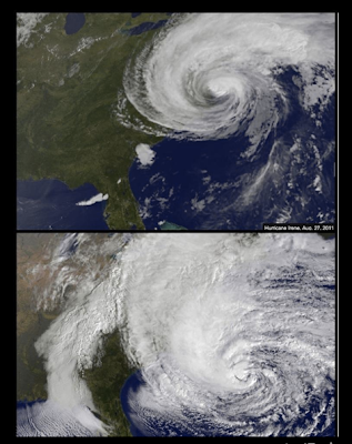
Mike projects the damage to be over $100 billion for Hurricane Sandy as the eyewall is about to make landfall  Mike and I spent the better part of the day Sunday in the car driving to St. Louis for 2 speaking engagements on Monday, one for the Chesterfield Missouri Rotary Club and secondly, as the keynote for the first annual Sustainable Disaster Recovery Seminar at St. Louis University. I got to see first hand the level of dedication and service to others that Mike devotes during a extreme weather emergency over the weekend. Mike was working in the car on the trip over, answering emails, conducting two interviews over the phone, one to USA Today and the other to a Kansas newspaper, following the latest radar images, blogging about the storm and what to expect, and putting survival information out on twitter and facebook. He told me that he was up working until 3:00 a.m. monitoring the storm as it raged through the night. Mike offers timely information to members of the

Sandy: Horrible Storm Surge Damage in New Jersey

Image
Two additions. Photo below from New Jersey National Guard: Snow depth image below from NOAA, hat tip: Jesse Ferrell at AccuWeather. Yes, that bright green is more than 40" of snow! Later info: 25% of the cell towers in ten states are out of service . The situation will get worse (due to generators running out of fuel) before it gets better. My friend, Brian Norcross, talks on his blog about the National Weather Service's poor decision not to issue hurricane watches and warnings even though a hurricane was forecast to occur. A thought-provoking piece from my friend, Dr. Bill Hooke: Will we learn the lessons of Sandy ? I especially like his aviation analogy. Those of you who are long-time blog readers know that I have advocated a National Disaster Mitigation Board similar to the National Transportation Safety Board There is great reading in the above two pieces from a couple of our profession's thought leaders.

"This Was Their Finest Hour"

Image
But if we fail, then the whole world, including the United States, including all we have known and cared for, will sink into the abyss… Let us therefore brace ourselves to our duties, and so bear ourselves, that if the British Empire and its Commonwealth last for a thousand years, men will still say, This was their finest hour.                                -- Sir Winston Churchill, June 18, 1940 I've thought of that famous quote from Sir Winston several times since Saturday -- when it became completely clear that Hurricane Sandy was going to be the multi-state disaster that had threatened for the previous two days. While victims and officials are still early in the process of sorting out this huge disaster, it is clear that unprecedented and extremely difficult-to-forecast Hurricane Sandy was meteorology's "finest hour." How good were these forecasts? Here is the European computer model's forecast made at 2pm last Wednesday. It shows a

You Read it Here First

Image
Dramatic New York Post photo at flooded LaGuardia Airport this morning. A post on this blog from Saturday showing a flooded LaGuardia: The last paragraph explains the flooding would jeopardize the NYC subway system . It will be days before JFK and LGA are back to normal.  Here is a list of the airports closed at the present time, courtesy of the Federal Aviation Administration:

More on Sandy

Image
AccuWeather has an excellent round up of facts and figures here . Line of electricity utility trucks eastbound on I-70 at Wright City, MO this morning Sources I trust tell me 8.5 million electrical customers (homes and businesses) are currently without power. That translates to 25 to 30 million people.  Crews are rushing in from around the nation but, given the geographic extent of the outages, it will be more than two weeks, and likely more than three, before power is completely restored (my opinion). The figures you are heaving in the media estimating total losses (i.e., direct damage plus economic loss) of $8 to $20 million are, in my opinion, way  too low. Time will tell. AccuWeather regional radar at 12:23pm EDT shows Sandy has spread out with winter conditions over the central Appalachians. There are still quite a few areas of gusty winds but they will largely diminish after sunset.

Was Hurricane Sandy "Hyped"?

Image
Friday, Saturday, and Sunday I saw blogs, Facebook postings, and even public officials (Mayor Bloomberg for one) either say the storm's forecasts were hyped or too dire. So, on Sunday, well before the storm struck, I posted some metrics so you could measure for yourself whether the storm was "hyped." It is too soon to know the damage toll from Hurricane Sandy but losses in excess of $20 billion are nearly certain. I think it may exceed $100 billion (worse than Katrina). According to a Tweet from The Washington Post,  7.5 million homes and businesses are without power. The peak land-based official wind measurement I have seen was 94 mph from the southeast part of NYC Metro.  There were many, many gusts above 75 mph in multiple states. Hyped? No. Excellently forecast? Yes. I'll have more on the quality of the forecasts later today or tomorrow.

Statement from NYC Transportation Authority

Staggering... Statement from MTA Chairman Joseph J.Lhota on Service Recovery The New York City subway system is 108 years old, but it has never faced a disaster as devastating as what we experienced last night. Hurricane Sandy wreaked havoc on our entire transportation system, in every borough and county of the region. It has brought down trees, ripped out power and inundated tunnels, rail yards and bus depots. As of last night, seven subway tunnels under the East River flooded. Metro-North Railroad lost power from 59th Street to Croton-Harmon on the Hudson Line and to New Haven on the New Haven Line. The Long Island Rail Road evacuated its West Side Yards and suffered flooding in one East River tunnel. The Hugh L. Carey Tunnel is flooded from end to end and the Queens Midtown Tunnel also took on water and was closed. Six bus garages were disabled by high water. We are assessing the extent of the damage and beginning the process of recovery. Our employees have shown remarka

Forecast for 10am EDT

Image
Here is the forecast radar: And, the forecast winds (in knots). One knot = 1.15 mph. Or, 30 kt. = 35 mph.

When You Hear Meteorologists Talking About Power Flashes...

Image
...in high winds, this is what we are talking about. Starts about :30.

Sandy No Longer a Hurricane: 11:11pm EDT Update

Image
At 11pm EDT, the National Hurricane Center says the center of Sandy (now, no longer a hurricane) was 10 mi. southwest of Philadelphia -- which is perfectly located by this wind map . It still has winds of 75 mph (sustained) but now weakening near the center. The pressure has risen to 952 mb. Here are the forecast winds for 2am EDT Tuesday. The scale at the bottom is in knots. Multiply by 1.15 to get miles per hour. For example, 30 knots = 35 mph. click to enlarge Here is the path of the remains of Hurricane Sandy which will continue to weaken. The latest (unofficial) figure I have seen is that 5.3 million homes and businesses are without power. That translates to roughly  20,000,000 people! Here is a brief recap of warnings: Deep purple = lake flood warning. Orange = blizzard. Pink = winter storm (a little less bad than blizzard). Green = river flood. Amber = high wind. NWS forecasts a major flood will occur on the Potomac at Hagerstown and Frederick with moderat

Hurricane Sandy is What We Feared

Image
Photo by Roberta Teer via Facebook Flooded, Dark Lower Manhattan.  Via The Weather Channel, three feet of water is flooding the floor of the New York Stock Exchange. Water has flooded into the NYC subway and the NY-NJ Path railroad.  The Statue of Liberty is dark. Both LaGuardia and JFK Airports are flooded, extent unknown. Wind gust of 94 mph at Eaton's Neck, NY confirmed by NWS. 2.5   4.0 million homes and businesses are without power as far away as Athens, GA. Winds as far west as Cleveland are gusting over 60 mph. A full-fledged blizzard is in progress in the Appalachians. Rivers will begin rising rapidly and major river flooding will occur over the next few days. There really isn't much more to say at this point. If you'll scroll down below, you'll see the forecasts that are still valid. If you are affected by the storm:  Hang in there. It may take a while but this, too, shall pass. UPDATE: The Weather Channel has retracted the NYSE report.

This is VERY Ominous: NYC Water Rise

Image
click to enlarge The storm surge (green line) is rising very rapidly. The tide (blue line) has turned and it now rising to a high tide around 8pm or a little after.  If the storm surge continues to increase at this rate, major flooding will result. This is another reason why, if the storm surge keeps rising, the NWS decision not to issue a hurricane warning was so ill-advised. This is what Mayor Bloomberg said Saturday: “Although we’re expecting a large surge of water, it is not expected to be a tropical storm or hurricane-type surge. With this storm, we’ll likely see a slow pileup of water rather than a sudden surge, which is what you would expect with a hurricane, and which we saw with Irene 14 months ago." The rapid rise (where the green and red lines come together) is exactly the characteristic of a hurricane  storm surge. The NWS's decision has misled many people. I hope and pray the water stops rising soon and a major flood fails to occur.  

Latest Wind Gust Projections

Image
Addition at 4:10pm EDT:  CNN reporting 750,000 homes and businesses without power in eleven states plus D.C. Original posting: 3pm EDT from National Hurricane Center. The eye of Sandy was 85 mi. southeast of Atlantic City moving northwest at 28 mph (very fast for a hurricane). Central pressure was 940 mb (27.76"). It is expected to make the coast in three to five hours.   Wind Gust Forecast 4pm EDT: The scale is in knots. In order to get mph, you have to multiply by 1.15. So, 60 knots = 69 mph. 70 knots = 81 mph. 80 knots = 92 mph. The scale only goes up to 80 knots. Note the extreme winds in Long Island Sound as well as the New Jersey coast.  Note also the gusts above 60 mph near the NC-VA border in the mountains as well as the increasing winds (gusts to near 50 mph from the north) over the Great Lakes. This is 6pm EDT: I have zoomed in because there are several important features. Winds at 30 ft (the standard meteorological measurement le

Could NOAA Be More Clueless?

Image
This just came in my email: Why aren't "all hands" working on Hurricane Sandy? Combined with the terrible decision not to issue hurricane warnings for the hurricane, this indicates to me that there is a lack of focus in NOAA about what is really important, a lack of situational awareness, or both. To this taxpayer: Completely unacceptable.

Eye of Sandy Now Visible on Radar

Image
click to enlarge The eye of Sandy is now clearly visible on AccuWeather regional radar. It is moving toward the west northwest. The highest winds are around the west and north sides of the eye and the bands extending from the eye. The developing blizzard in the mountains is highlighted on our winterized radar.

Sandy: Surge, Wind, Rain, Snow Update

Image
Atlantic City is "mostly flooded" according to local officials. Water levels will only continue to rise through at least 8pm and probably until midnight. Other coastal cities are now being flooded. Here are the latest forecasts from my colleagues at AccuWeather: Storm Surge. Water (with waves + tides) will reach as  far as 30' above sea level in places! Note the characterization of "Devastating." Ground-Level Wind Gusts Wind gusts will likely be over 100 mph at the tops of high rise buildings in and around NY-Newark and south into New Jersey D.C. - Baltimore should have gusts to 75 mph.  Additional Rainfall and Snowfall. Blizzard in the Mountains

Comparison of Irene and Sandy

Image
Update 10:20am CDT:  Pressure has dropped again to 937.5 mb. Sandy breaks another record for pressure every time it drops. This is lower than forecast for 2pm EDT, so the storm may be strengthening even more than expected. Parts of Atlantic City are already flooded. And, the water is only going to rise to "major" flood levels.  ORIGINAL POSTING: In this case, bigger = worse. Irene on top, Sandy on bottom. The Hurricane Hunters have now measured a pressure of 939 millibars, which is lower than forecast  and the storm is still strengthening. It may reach Cat 2 hurricane strength before landfall. There is a report of sustained winds of 90 mph just off the coast of Long Island with gusts well above 100 mph. I believe (as previously stated, scroll down to Saturday's postings) the NWS's decision not to issue hurricane warnings for Hurricane Sandy was a very poor decision. Update 10:20am:  Hurricane warnings in effect off the coast but only "hurricane for

Hurricane Sandy Moving In

Image
Here is the latest satellite image of Hurricane Sandy. She is strengthening and moving northwest. The pressure is 946 mb and has sustained winds of 85 mph. I expect Sandy to strengthen to 90-95 mph sustained winds with peak gusts to 100-110 mph. Winds on Long Island are now gusting to near 50 mph. They will only go up today. Here are some illustrations: Sandy at 2pm EDT The pressure is forecast to drop another two millibars as it moves WNW toward the New Jersey coast.  Wind Gusts at 4pm EDT The scale is in knots. In order to get mph, you have to multiply by 1.15. So, 60 knots = 69 mph. 70 knots = 81 mph. 80 knots = 92 mph. The scale only goes up to 80 knots. Note the extreme winds in Long Island Sound as well as the New Jersey coast.  Note also the gusts above 60 mph near the NC-VA border in the mountains as well as the increasing winds (gusts to near 50 mph from the north) over the Great Lakes. Forecast for 8pm EDT Note the winds are very high in the Washington

"The Most Important Forecast Since D-Day"

Image
While I'm working on the update, my good friend Bill Hooke has written a piece I highly recommend: The whole piece is here .

Never Have I Been Less Happy to See a Forecast Coming True

I have been making forecasts almost every day of my life since 1967. I don't think I've ever been less  happy to see one come true. The latest USAF dropsonde (a measuring device dropped from a Hurricane Hunter aircraft) shows the pressure in Hurricane Sandy has dropped to 948 mb and winds are correspondingly increasing. The National Hurricane Center is now forecasting sustained  winds of 90 mph later today -- that implies gusts above 100 mph! The storm is now in the process of making its northwest turn. Winds are already gusting to 40-50 mph on Long Island. I'm working on a full update but wanted go ahead and get this out.  I'll have the update up as soon as I have it finished.

"Aerial America - Kansas"

Image
Just watched Smithsonian's Kansas version of Aerial America. Very well done. Details here .

Detailed Wind Forecasts

Image
Hurricane Sandy at 8:15pm EDT. It is located east of the North Carolina Outer Banks. Wind Projections This is the approximate wind pattern across the region. The brighter red then brownish colors equal stronger winds. Forecast for 10am EDT Monday. Forecast for 2pm EDT Monday. These are gusts near 100 mph southeast of Long Island. Tremendous amounts of water will be driven toward the shore. Forecast for 6pm EDT Monday. Note the relatively calm winds in and just southwest of Sandy's eye. Fiere winds over Long Island Sound, water being driven inland. Forecast for 8pm EDT Monday. High winds continue over Long Island Sound.  Forecast for 7am EDT Tuesday. Strong winds now over the Great Lakes with nearly calm winds with the center which has moved west of Harrisburg. The rest of the forecast still looks good. A record surge is predicted by the NWS for New York Harbor. Three inches of snow is already on the ground in West Virginia. Here is the

Do We Properly Value the Storm Warning System?

Recently, I have spoken to a number of civic groups throughout the Midwest and asked the question, Do we as a society properly value the storm warning system? I believe the answer is clearly "no." The National Weather Service budget keeps getting cut (no, not "cut" relative to inflation but actually cut). In that presentation, I talk about the instrumental systems -- essential for accurate forecasting -- that we will likely lose. So, I was pleased to see The New York Times  with a article about the looming crisis in our weather satellites . The meteorological infrastructure and storm warning systems are one of the few areas in the federal government where we get more than our money's worth. The NWS budget is 1/39th (no kidding!) the size of the budget of the Department of Homeland Security. Where do you think we are getting the better value? By the way, you are looking for a professional speaker (and they say I "talk the same as I write"),

Follow Me on Twitter

I Tweet @usweatherexpert.  With being on the road, I'll tweet items of interest the next two days.

2:25pm Sunday: Hurricane Sandy Forecast

Image
Look for a landfall late Monday in Delaware or New Jersey for Hurricane Sandy. At 2pm EDT, Hurricane Sandy was on predicted course with 75 mph winds and a central barometric pressure 951 millibars. This is the predicted  wind field for 2pm EDT. It compares reasonably well with current weather station measurements if you use it for wind gusts in miles an hour. For example, Norfolk, VA is gusting to 50 mph. So, how does the wind field change over time? 8am EDT Monday Due to the falling pressures, the wind speeds are accelerating. Wind gusts above 50 mph are occurring on DelMarVa and into New Jersey. They are just making it to Long Island. 2pm EDT Monday Barometric pressures are dropping like a rock and wind speeds are spinning up accordingly. The bright orange colors are gusts to about 60 mph with the brown tones above 75 mph. Power failures will be occurring in large numbers and the storm surge will be piling up water.  This would be a record low barometric pressur