Posts

Showing posts from May, 2019

The Wichita River Festival Opens This Evening

Image
One of the festival's hot air balloons going over my house a few minutes ago The Wichita River Festival opens this evening with balloons, the Twilight Pops Concert and fireworks. Come and join us!

Seven-Day Rainfall Forecast

Image
While not the torrential rains we've experienced, this is far more rain than we would like to have at this point. Statistically, this is the wettest time of year in the central Great Plains, so this would not be unusual. However, because of the recent extreme rains this could cause additional problems.

A Back of the Envelope Guess As to How Many Lives Were Saved Tuesday by Kansas' Tornado Warnings

Image
This was late Monday evening in Dayton, Ohio. In darkness, a rare (~1% of all tornadoes), violent EF-4 tornado was approaching densely populated Dayton . Yet, numerous people were calling the station to complain about missing The Bachelorette. Finally, a television meteorologist gave them a piece of his mind. With the excellent warnings (I was live-tweeting and watching the Dayton TV coverage), the death toll was zero. Fast forward about 19 hours... You'll recall that I wrote a book about the failure of the warning system during the Joplin Tornado .. a storm that killed 161 people. There were many similarities in the Joplin Tornado and Tuesday's Northeast Kansas Tornado. Both were 1-mile wide at times. Both were rain-wrapped and their approach could not be seen. Both were in May (5 calendar days apart) about the same time of day.  Both originated in Kansas.  But, there is one huge  difference: The warning system failed in Joplin while it worked beautifully (a

Two-Week Rainfall Totals

Image
The great tornado and rainfall siege began two weeks ago tomorrow (Friday). Here are the two-week rainfalls over the affected areas as of this morning. click to enlarge There were areas in Kansas, Missouri and Oklahoma that received between 15 and 20" with point amounts likely higher. Of course, record flooding continues in many areas. While nothing like the rainfalls of the last two weeks is forecasted by anyone of which I am aware, here is the NWS's forecasted rainfall for the next two weeks. Addition: I mentioned that point amounts were higher. Take a look at some of these totals. All of these are in southern #Kansas. 

The Great 2019 Siege of Heavy Rain and Tornadoes Is Over

Image
While there will certainly be more tornadoes and more flash floods in 2019 (like there are every year), the great siege of 2019 is over tonight.   The low pressure system and quasi-stationary front that triggered all of this vast destruction have finally de-coupled and moved away. But, not before untold billions in damage and destruction. There are many aspects of this unusual event that deserve comment. The Forecast: The most amazing thing is that this highly unusual event was forecast well in advance on this blog and elsewhere. The first extended forecast of high numbers of tornadoes, including violent tornadoes, was published May 12  here . Five days before the first of the tornadoes. More on the forecast of flooding, published May 17, here . I believe you'll agree they were remarkable forecasts five days before all this began..  Take a look at the red areas above and compare it to the tornado map (ending this morning). Not only were the high numbers in the Great Pl

Thank You

Image
I just saw this: Thank you so much! If you would like to follow storm coverage and my take on other topics at Twitter, just follow @usweatherexpert. 

No, Tornadoes Are Not Increasing Due to Global Warming Or Any Other Reason

Image
Because, according to the national media,  everything  is caused by global warming, here are two more articles in the last 24 hours lamely trying to tie tornadoes to global warming. They are here and here . You'll find lots of weasel words like "consistent with" but they all avoid one very inconvenient truth. The number of strong tornadoes -- the type that kill people -- are dropping. So, if the "background odds" are changed by global warming, the background odds are making big tornadoes less likely  Remember: if global warming isn't an extreme crisis, the research dollars drop.

Today's Tornado Risk

Image
There are two areas of tornado risk today. One is the Middle Atlantic region including New York, Washington, Philadelphia and Pittsburgh. The other is an enhanced tornado risk from Little Rock and the southern Ozarks through Dallas-Ft. Worth. The hatching indicates that strong tornadoes are forecast to occur. This is the last day of the tornado and flood siege! I'll have more later today.

One of the Most Important Days in the History of Science: 100 Years Ago Today

Today is the 100th anniversary of the experiment that proved Einstein's Theory of Relativity.  There is a brief, and very readable, explanation here . Here is the most important paragraph (attention people in the field of climate): Here we might also note, in the field of epistemology Einstein’s theory of general relativity as the “perfect theory” and Eddington’s verifiability test, have become the gold standard of what Karl Popper termed “conjectures and refutations” as the basis of advancement in our knowledge of the universe and its working. How do we know what is scientifically true, and Popper indicated “by saying that  the criterion of the scientific status of a theory is its falsifiability, or refutability, or testability ” (italics given). The word "consensus" does not appear. 

A Way Out of the Antibiotic Crisis?

A fascinating read, here . The answer may be Civil War era herbs.

Another Day of Heartbreaking Tornado Damage

Image
As of 11pm, there are no reports of deaths in another day of tornadoes in densely populated areas. People literally owe their lives to meteorologists.  Today was a day of multiple tornadoes over multiple states. Kansas was the hardest hit with two long-track tornadoes. You can scroll down if you wish to view some of the forecasts. Red triangles = tornado reports The more serious of the two occurred in northeast Kansas and northwest Missouri. Kathleen and I chased the northeast Kansas tornado and, based on what we were hearing from the Topeka radio station to which we were listening, the field reports were helpful to other meteorologists. For example, I took, tagged and tweeted this funnel cloud photo (below) when the rotation was between Lyndon and Overbrook (lower left on map, above). Like the Joplin Tornado, this tornado was rain-wrapped and nearly impossible to see. Here is what rain curtain containing the tornado looked like when it was near Lawrence. Photo taken lo

For Additional Severe Weather Information...

..I expect to tornado chase this afternoon so that means there will be only intermittent coverage on the blog. To get additional updates, follow me on Twitter at: @usweatherexpert 

1:55pm CDT Severe Weather Threat Update

Image
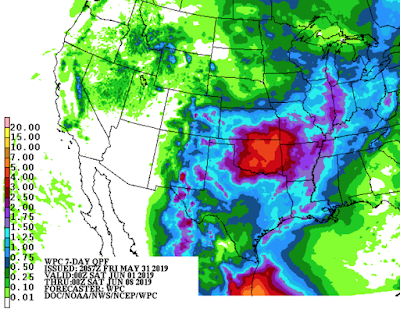
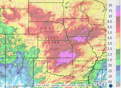
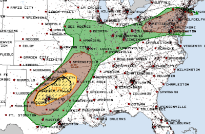
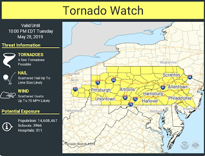
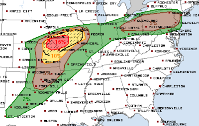
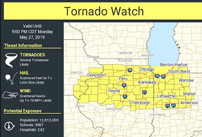
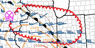
A tornado watch has been issued for a large area from Ohio to New Jersey. I urge  people in this region to keep up with the latest weather information! Large hail is also a very significant threat.  2:45pm EDT radar shows thunderstorms developing rapidly across this area. The red polygons on this map are severe thunderstorm warnings. In the Midwest, I believe the outlook below from SPC is quite good. However, later data indicates the higher threat has enlarged farther south into north central Oklahoma. So, I have added red stripes to indicate where I believe scattered supercell thunderstorms with very large hail and, perhaps, destructive tornadoes could occur as the dry line is strengthening significantly. This includes Wichita, Emporia, Salina and Manhattan. The dry line extends from Russell, Kansas, to Alva, OK and is moving east. Thunderstorms will form in the next couple of hours along and east of that line. Note: I'm storm chasing the rest of the day. Please fo

Major Tornado Risk This Afternoon and Overnight

Image
I am extremely worried about tornadoes this afternoon and tonight. Let's break down the threats: Brown (5%) is the significant tornado risk. There are two areas at risk. One in the Upper Ohio River Valley from Ohio to Pennsylvania and New Jersey. This includes Cleveland, Pittsburgh, Philadelphia and Newark. The second is in the Midwest. The yellow area is 10% and the red is a high 15%. Hatching means that violent tornadoes are possible. This includes Kansas City, Topeka, and St. Joseph. The NWS Storm Prediction Center made this map and I agree with one exception. I would have brought the hatching down to Wichita. Giant hail is possible in the tornado threat areas along and north of the Missouri River. What Should I Do Now? Below are safety suggestions you can implement now, before the storms begin: Because of the higher than average overnight tornado risk, I strongly recommend downloading both the  AccuWeather app  (scroll down to bottom of page). Be sure to allow l

Good News From Dayton!

Image
The Dayton area damage was as bad as expected but there is wonderful news this morning: No deaths!   Think about that: A violent tornado that struck after 10pm on a holiday weekend evening produced 40 injuries but no fatalities. Without the tornado warning system, a storm of this nature would have killed scores. Meteorologists have been working insane hours under extreme stress the last two weeks. If you know one, thank them. Or, send them a note on Twitter.  Dayton Daily News

Two Areas of Violent Weather

Image
11:00pm CDT Multiple, violent tornadoes have occurred in Ohio this evening and tonight after an afternoon and evening of tornadoes in Indiana and Illinois. There is a second area of sever thunderstorms and one area of tornadoes in Nebraska and far northern Kansas. THIS WILL BE THE END OF MY COVERAGE FOR TONIGHT

Violent Tornadoes in the Dayton Area

Image
It has been a day with numerous tornadoes in Iowa, Illinois, Ohio, Colorado and Nebraska. As of this time, the worst appears to have been in the Dayton Metro area. Based on radar and ground reports, considerable damage has occurred and there are injuries. The arrows denote the paths of the two tornadoes as of 11:39pm EDT. The more southern tornado, so far, is the one with the most damage reports. Addition 12:05a EDT. This is a map of the rotation path, which equals the approximate tornado path, of the first of the two Dayton-area tornadoes. This was the stronger of the two.

Attention: Managers in the Field of Weather Forecasting

Image
[If you aren't interested in some of the "inside baseball" aspects of  weather forecasting, please skip this posting.] Surface Chart from a 1974 Tornado Outbreak, I did hand analysis on it, which is why I kept it. This posting is not fun to write but it is important. Some caution signs are appearing in the fields of weather forecasting and storm warnings. I suspect I know why: 1) my generation of meteorologists, with our deep experiences during a wide variety of weather conditions have largely retired, 2) we are allowing young forecasters to get away with forecasting using techniques that make them "comfortable" rather than by using techniques proven to yield superior results. In this essay, I am talking about plotting surface weather maps (there are other techniques I could cite). Two items from the last seven days highlight this issue facing weather science. My superior heavy rain forecast earlier this week. I cite this forecast not to brag but

Tornado Watch: Eastern Iowa, Northern Illinois and NW Indiana

Image
The area outlined area, which includes Chicago and its suburbs, has a "high" risk of tornadoes and a "moderate" risk of strong tornadoes. As of 1:36pm, I don't like the look of the intensifying storm west of Joliet. Please keep an eye on the weather throughout the tornado watch area!

Heads Up: Eastern Iowa, Northern Illinois and Northwest Indiana

Image
Because of the holiday, I am going to cover the tornado threat  in the headlined area.  There is a serious threat of tornadoes in the outlined area. This includes Chicagoland. Please make sure your family and friends are aware. With people being outdoors, etc., the word may to get out as fast as usual.  At 1:28pm, there are already tornado warnings in SE Iowa with increasing thunderstorms throughout this area. When the tornado watch is issued, I will post it. 

Memorial Day Reading

Today is a day to honor the (sometimes ultimate) sacrifices made by our Armed Forces. But, as informed citizens in our Republic, it is important, going forward, that we intelligently weigh the costs and benefits of our foreign policy. Agree or not, I find this to be a compelling read and highly recommend it.

Whether It Is Railroad Crossing Gates or "Road Closed" Signs For Flooding...

...please teach your children to respect these barriers. We nearly had a tragedy in the Wichita suburb of Park City.

128 Tornadoes and Counting

Image
Since the Great Plains Tornado Siege Began on May 16 there have been 128 tornadoes. Fortunately, thanks to the storm warning system, there have only been (to my knowledge) 3 deaths. More are forecast today (see below).

Monday's Tornado Risk

Image
There are two areas of signifiant tornado risk. One includes Chicago, Quad Cities, Rockford and Peoria. The brown is the significant tornado threshold. Yellow is an enhanced risk and the hatching is the area where violent tornadoes are forecast to occur. The other area of significant risk is in the High Plains of Nebraska and Colorado including Scottsbluff, NE and Akron, Colorado. Please keep up on the weather in these areas.

Reminder: Turn Around, Don't Drown

Image
Via Twitter

Amen!

Image