Friday, June 30, 2023

Today's Tornado Risk

With everyone traveling today, it is important to note that the brown ('significant risk') area is along I-70 and U.S. 40 in western Kansas and eastern Colorado. 

The Huge Number of Drowning Deaths in Rip Currents

With the holiday weekend at hand, the caution regarding rip currents is timely.
I had no idea so many were drowning in them.

Vital safety information is here

They can be easily seen from above, as in the photo, but are difficult to see at beach level. So, I urge you to follow the flags and the advisories online and on the radio.

Thursday, June 29, 2023

Another Quizzical Tornado Warning

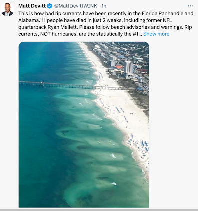
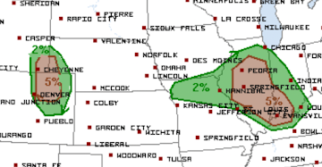
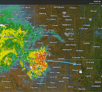
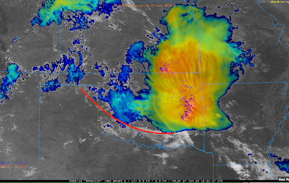
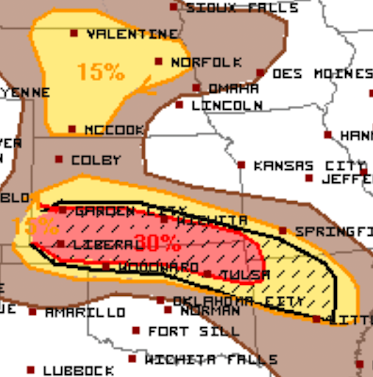
While this tornado caused damage in central Illinois early this afternoon, hopefully no one has been injured. But, I simply don't understand what transpired and I'm hoping some of my helpful readers can fill me in.

The possibility that tornadoes could occur in central Illinois was forecasted by the NWS Storm Prediction Center at ~11:45am (brown, below).
Given the fact that a derecho was approaching the area at 70 mph, it was essential Lincoln - Central Illinois radar be switched to the 80-second "tornado" mode.

At 12:06pm (velocity time, upper right of the frame), there was very weak rotation just west of Berlin, IL. 
Had it been me, I would not have issued a tornado warning at this time. The rotation was too weak. I have highlighted the town of Loami, which becomes important in the next frame. 

Because of the 3.5 minute interval between frames, the next data indicates a full-fledged tornado is doing damage! Any hope of advance warning was lost because the radar was operating at ~210 second interval intervals rather than 80.
At upper right, the rotation is robust. At lower left, the spectrum width data (gray pixel) likely shows the center of the funnel. At lower right, the lowered "correlation coefficient" depicts lofted debris. 

The National Weather Service (NWS) in Lincoln issued a tornado warning at 12:12pm. 
This warning has negative "lead-time" (-3 minutes; the tornado was on the ground at least three minutes before a warning was issued), it says the tornado is moving "east." If it was 9 mi. west of Springfield, it should be moving toward that city.

It also says "radar indicated rotation" when it should say "radar confirmed," which gives it extra credibility, because of the lofted debris. Finally, it says the tornado is near Loami "moving east at 55 mph." The problem are it is not over Laomi and an east movement would take it along I-72. All of this is wrong. 

At 12:12pm, the tornado is clearly moving southeast not east. 
The rotation (upper right) continues. The location of the funnel (spectrum width, lower left) and the greater amount of lofted debris (lower right) are in precisely the same location. The tornado continued to move along the ground. 

I had been tweeting about a potential tornado farther north didn't begin noticing this storm until the tornado warning came out about about 12:14pm. 

But, when I took a look at several frames, it was obvious the "east" movement was wrong. The tornado was exiting the tornado warning (red) polygon. Rather than explain, I thought it was essential to get something about as quickly as I possibly could. Note the storm was nearly over Chatham and well south of Springfield.
The NWS reissued the tornado warning and oriented it toward the southeast. 
But, the text of the tornado warning said is was moving "east at 75 mph"!
So, to someone listening to the radio or not having access to video, they would have been misled as to the area threatened. This is part of what went wrong a dozen years ago in Joplin!

Did the Tornado Cause Damage?
Unfortunately, the answer is "yes."

Part of the roof lifted off

Power Outage Map
The red county in the center represents half of the customers out of power. 

These reports are highly preliminary.

The point is that it wouldn't have mattered if it was a weak tornado (which is likely the case) or a strong tornado -- the radar can't see a tornado if it is not looking. With tornado mode, it would have been looking nearly three times as quickly.

But, there are other troubling aspects to this incident. 
  • Why the obviously wrong direction of movement? 
  • Why wasn't the wrong direction corrected?
  • Why use a tiny town as a geographic reference that wasn't nearby or in the path?
  • Why not say, "radar confirmed" -- giving the warning added credibility -- as it was?
The recent fatal tornadoes are more important than this incident. But, this clearly demonstrates that running the radar at the wrong data interval and other issues are not confined to one state or region. 

Wind Energy is Falling Apart -- Literally

The full story is here.

Updated 12:10pm: Midwest Derecho In Progress

Significant Risk of Tornadoes in Brown

Damaging Wind Forecast
The hatched area is where wind gusts of 75 mph or stronger are forecasted to occur.  The purple is the highest probability.

Here is the radar at 12:04pm. There is a second line of thunderstorms with damaging winds moving into northern Tennessee. It will move across Nashville soon.

We are approaching 100,000 people without power and that number will grow. 


National Weather Service Tornado Warnings: What Is the Fix?

We have discussed the fatal tornadoes of the past seven weeks (here, here and here) in addition to the numerous other examples from earlier this year. 

What is the solution?

I'm not sure. 

One very quick fix would be for the head of the National Weather Service (NWS) to issue an immediate order for the field offices to stop the nonsense as regards radar operations when tornadoes are forecast: the radars immediately go on 80-second update intervals until things are all-clear throughout their county warning area. 

Running the radar at seven-minute intervals during a tornado forecast is a formula for utter disaster, especially at night. 

The rest isn't as clear. Undoubtedly, there is a training issue. A quarter-century ago, the NWS ran a 4-week radar and storm warning training course in Norman, OK and all of its meteorologists were required to attend. That no longer exists. With the retirement of my generation of meteorologists, all of that expertise has walked out of the door.

I'm convinced there is more to it than training and radar data intervals but I don't know what the additional issue(s) might be. That is why -- more than ever -- I'm convinced we need a National Disaster Review Board (NDRB), modeled after the highly successful National Transportation Safety Board -- to look into NWS, FEMA, emergency management and other entities that serve the disaster space. 

The NWS seems resistant to the idea of a NDRB but there are advantages. It would provide political cover for increasing the number of radars, changing software, et cetera. While I am a Reagan conservative and hate to see government grow, the advantages far outweigh the disadvantages. One note: since we already have panels that handle global warming, the NDRB must be forbidden to get into the global warming controversy. 


Wednesday, June 28, 2023

Matador: Another Fatal Tornado Without Adequate Warning

After initially believing the warning for last week's Matador, Texas, Tornado was adequate, my opinion has -- strongly -- changed.

Investigative Report
© 2023 Mike Smith Enterprises, LLC

After receiving suggestions from chasers in the field and others, I've reviewed the National Weather Service (NWS) "chat" from the Lubbock and Amarillo field offices. Those concerned individuals are correct. This incident is just inexplicable.  

It was Lubbock that had the responsibility to provide advance warning for Motley County on June 21, 2023. Keep in mind the National Weather Service's stated goal is 13 minutes' advance warning for a tornado. From 2000 to 2010, the NWS routinely achieved that goal. It has regressed considerably since. 

The first issue was -- yet again -- the radar was being improperly operated during a tornado watch. Instead of operating the radar at 80 second data collection intervals, the radar was set to collect data at 360 second intervals -- six minutes between scans! When the radar is set at the more frequent interval, it is possible to provide emergency storm warnings more quickly. 

Here is a timeline of the meteorological events that evening in west Texas:

7:40pm CDT Radar
At left is the reflectivity data (the type of radar you see on TV). The storm is moving nearly due south (arrow). The developing "hook echo" (circle) is a sign of a tornado but there is a weak area in the center. That is evidence of a rotating updraft spinning precipitation (raindrops and hail stones) out of its center -- which is another precursor to a tornado. The velocity data (right) is contaminated by what meteorologists call "side lobes." However, using the radar's next step up vertically (not shown) clearly shows strong rotation. 

A tornado warning should have been issued by this time for northern, or all of, Motley County. 

At 7:42, the Lubbock NWS meteorologist received a report of a utility pole leaning at a 45° angle due to high winds (caused a tornado or otherwise) from this storm. 

7:45pm Radar
At this time, the radar is screaming, "issue a tornado warning!"
At left, here is now a definite hook echo (red). The hail forms the shape of an arc which means the supercell's updraft is strong and able to be concentrated into a strong tornado. At right, the velocity data shows strong rotation in the forward part of the hook, which is the classic tornado signature. 

But, instead of issuing a tornado warning, the Lubbock office issued a severe thunderstorm warning for hail and high winds. It has the option, in that type of warning, to add the phrase, "tornado possible." It did not. The tornado is just nine miles from the town and closing. After the fact, the Lubbock NWS chooses not to survey this area. I won't speculate on the reason but a survey should have been conducted. I am confident it would have demonstrated a tornado was on the ground with no warning,  

7:49pm
Meteorologist Kevin Selle was live-broadcasting the tornado on his video stream. We know the NWS was aware that the tornado was being broadcast because it is on their Amarillo chat! Amarillo states they are passing that info on to Lubbock.
12:49 UCT = 7:49pm CDT.
This was Amarillo NWS's office's chat. 
Adding together: the radar was on the wrong scan strategy + what the Lubbock office knew from the 7:45pm radar data + plus the knowledge a tornado was already on the ground, to have not issued a tornado warning for Motley County = a level of ineptitude even beyond the previous cases I've documented. 

Instead of issuing a tornado warning, the Lubbock NWS meteorologist notes in the chat (but not for the public, only on the internal chat with TV and other meteorologists), "Very, very strong updraft coupled with solid mid-level rotation." While he adds "tornado possible" to the severe thunderstorm warning already in effect, the public does not see that addition.

It is simply incredible that a tornado warning had not been issued. 

7:51pm Radar
This is the type of radar image of a tornado they put in college meteorology texts. 
I have outlined the hook (left) in the reflectivity data. Classic. At right, the velocity data shows the tight rotation (known as a "gate-to-gate couplet") is centered on the leading edge of the hook. This is what they teach students is a tornado as sensed by radar. The tornado is just six miles from the town and moving in. 

Keeping in mind they are aware that Kevin Selle has been broadcasting the tornado -- live -- the following statement on the chat is inexplicable:

Lubbock NWS chat
12:51 UTC = 7:51pm CDT
Rear flank downdraft appears to be quite strong with a sizable downburst wind threat. Circulation 'not sufficiently tight' to suggest a tornado but isn't far from that. Storm bears close monitoring.

This was another inexplicable statement. Radar meteorology 101 tells us that gate-to-gate is as tight as it gets. And, how is this data not "suggest[ing]" a tornado? One is being broadcast.

7:56pm
Lubbock's chat has the following reports of a tornado in progress:
  • Chaser Daniel Shaw is 3 mi. NNW of Matador, a tornado is 2 miles to his northeast. 
  • Corbin Voges, a storm chaser, has a brief video (note it is the video that is brief) of a tornado north of Matador.
  • Media meteorologist Matt Massey points out to the NWS, which has responsibility for issuing a tornado warning, writes that the velocity data (right panel of above radar image) is "interesting." I believe that was a diplomatic attempt to prod Lubbock to issue a tornado warning. 
  • Sammy Brence, a chaser meteorologist, was reporting a "large tornado" 3 mile NNW of Matador and that is rain-wrapped, meaning it cannot easily be seen. 
The NWS -- at long last -- issues a tornado warning for southern Motley County even though there is a tornado in progress in the center of Motley Co., 6 mi. north of Matador.
Note they do not disclose there is a tornado in progress. They note a "wall cloud" which implies a tornado has not formed yet. At the bottom where it says "TORNADO" they can put "OBSERVED," "RADAR CONFIRMED" or "RADAR INDICATED." Inexplicably, they chose "radar indicated."

7:57pm
Radar shows the tornado is now just 3 miles from the city but, per reports, the tornado may have been invisible from Matador because it was wrapped in rain. This seems plausible because the hook is rather thick at this point. 
The right panel, the wind velocity data, shows the strong rotation still gate-to-gate. 

Storm chaser reports at 7:57pm:
  • Ben Holcomb is 3 mi. NNE of Matador reporting the tornado is approximately 2 miles north of his position. 
The Lubbock NWS meteorologist writes on chat -- the public does not see this  -- "multiple confirmations of a tornado on the ground in Motley County."

7:58pm CDT
The Lubbock meteorologist updates the tornado warning to an "observed" tornado and says it is 4 miles north of the town. 

Reports of the tornado continue to be received, including from the Motley Co. sheriff's office. 

The radar mode, now that the tornado is on Matador's doorstep, is switched to 180 second mode. You'll recall it had been set to 360 second mode. This is an improvement but, unquestionably, should have been set to 80 second "tornado mode."

Skipping Ahead to the 8:03pm radar 
Based on the radar, the tornado has reached Matador. 

We can zoom in and add an additional type of data for confirmation. 
If you look closely, the streets of Matador show up as thin blue lines. The velocity data (upper panel) shows the center of the couplet which corresponds to the location of the tornado is at the northernmost street of the city (give or take a small distance).

The lofted debris data (known as a lowered "correlation coefficient") shows lofted debris over the city. So, within a minute or so, 8:03pm is the time of arrival of the tornado in Matador. 

Later Reports
  • 8:14pm, law enforcement reported that, as of 8:11, there was damage in the City of Matador.
  • 8:14pm, Val Castor's (well-respected storm chaser from Ch 9 in Oklahoma City) video feed showed severe damage on the north side of Matador. 
From the News Media

Barbara, who recently moved to Matador, recalled little warning when the tornado hit

                                                                        ---  Lubbockonline.com


Nicky Dempsey was heading home with her daughter when she noticed how dark the sky was to the north of her house. She thought it was hail or rain, since she didn’t see anything on the radar. Then she heard the faint sound of sirens and told her family to get in the basement as quickly as they could. 

                                                 --- Via Texas Tribune


Four people were killed and 9 were injured by the tornado. The tornado was indeed "strong" -- EF-3 intensity. 

The city depended on the NWS for a warning because, per storm chaser reports, the tornado was invisible due to it being surrounded by rain. Had the tornado been visible, the emergency manager may have had the option to operate the sirens independently.

Tornado Warning Lead Time
The tornado warning was issued at 7:56pm. Given Selle's of the video of the tornado in northern Motley county, at best, the lead time would be -7 minutes. However, that is really giving the NWS the benefit of the doubt as they never issued a tornado warning for that area.

For the City of Matador, the National Weather Service's tornado warning was issued at 7:56pm. With the time of arrival in the city of 8:03pm, that would mean the lead time was +7 minutes. Given the NWS's published goal of 13 minutes, this was far shorter than it could have been. 

Had the tornado warning been issued at 7:40pm -- which is when it should have been issued -- the lead time would have been 23 minutes. 

Discussion

On May 22, 2011, the NWS botched the warnings for the Joplin Tornado. One hundred sixty-one people lost their lives. While a storm of that intensity crossing a densely populated area would have caused dozens of deaths, the extreme loss of life was confirmation of the inadequate warnings as it, too, was rain-wrapped and invisible as it crossed the city. 

Unfortunately, the National Weather Service seemed to learn the wrong lessons from that storm. And, since, the tornado warning program has fallen apart due to those program issues combined with the retirement of its well-trained meteorologists. 

The service’s own figures demonstrate that their warning accuracy has deteriorated by 24%. In addition to the decrease in "probability of detection" (whether a tornado warning is out before the tornado touches down), the lead time (the interval between and warning and the arrival of the storm) has collapsed by a whopping 58% (below). 

Since 2020, we don't know what has occurred, although I suspect continued deterioration. The accuracy figures, when they were good, were out in the open. Now, they are behind a password and login. 


The bottom line: people are dying because of these issues. 


And, I am terrified, as are other meteorologists, that -- absent strong, immediate action -- another Joplin is inevitable. 

Now that I have documented the Matador storm and the attendant warning issues, I am going to write up a summary of these issues and my recommendations for repairing them. I hope to have it by the end of the week.

Tuesday, June 27, 2023

Derecho With 100 mph Winds and 3" Hail...

Update  10:40pm, the cluster of thunderstorms which comprise the derecho as constricted in north-south extent with the resulting strongest winds near the KS-OK border. See below:
Peak winds near the arrow will be around 70 mph with less strong gusts as you move away from it in the north or south directions. 

I do not think Tulsa will receive damaging winds overnight. 

----------------------
...in addition, a "couple of tornadoes" are forecast to occur.
This severe thunderstorm watch is in effect until 2am CDT.  This is a highly dangerous situation.
  • If friends or family live in a mobile home, call them and suggest they spend the night. 
  • Power failures are likely. I urge you to prepare. 
  • Trees will likely fall, If you have a chain saw fill it with fuel. Fill your car with fuel (pumps and chargers don't work) in advance of losing power. 
  • Get a few extra dollars at the ATM. Cash is valuable when card-readers don't work.
  • Make sure the children are aware.
  • Pick any ripe tomatoes. 
Please monitor local weather information the rest of the evening if you live in these areas. 

Update 7:47pm:  A wind gust of 114 mph was measured in the eastern Oklahoma Panhandle.

High Risk of Damaging Winds With Tonight's Derecho!

The meteorological question is: will the thunderstorms in southern Kansas this morning (now in eastern Kansas and Oklahoma as seen on the satellite image below (12:45pm). The red line is the collision between the extremely hot and unstable air to the south and the rain-cooled air to the north. It is going to have to change direction in Oklahoma and move back to the north for this system to -- unfortunately -- reach its whole potential.

There is a low pressure system in the upper atmosphere that was approaching the KS-CO border and was expected to arrive around 4pm CDT.

FORECASTS
Because of the presence of the rain-cooled air boundary, there is a slight risk of a tornado in the area outlined in red. 

The area in purple has a high risk of winds of 60 mph or stronger. A "derecho" (an area of damaging winds that extends for more than 100 miles):
Here is the color code:
  • Purple is a high risk of winds of 60 mph or stronger. In addition to the highest risk of damaging winds, giant hail ≥ 2" may occur. 
  • Red is an enhanced risk. 
  • Yellow is a significant risk.
However, where you see the hatching, the forecast winds may exceed 75 mph. 

Now is the time to prepare! Safety recommendations are below:
  • Call friends and relatives to make sure they are aware of the threat, especially if they live in a mobile home. 
  • Make sure you have at least three ways of receiving storm warnings. Since the threat along and east of Interstate 35 will be at night, StormWarn is a great way to receive information. It worked great at 11:30 last Saturday evening when we had a tornado warning that included my home.  
  • If you live in a mobile home, you may wish to move spend time with a friend or relative when a tornado or severe thunderstorm watch is issued. 
  • Ask yourself what you would need if you were without electricity for five days. In some areas it will be longer, but five days is a good planning target. If you think I am exaggerating, some in northeast Oklahoma were without power for a week!
  • Battery-operated fans for the same reason (it will be quite hot the next few days)
  • In Houston, people died due to carbon monoxide poisoning due to misuse of generators after their windstorm last week. If you have a portable generate, make sure it is full of fuel but -- above all -- follow the manufacturer's instructions for use. 
  • If you have a chain saw, fill it with fuel.
  • Check your tornado shelter. Make sure it has a couple of bottles of water and, if appropriate, diapers.
  • Any essential foods or medicines should be taken care of immediately, well before the storms arrive. 
  • Have all of your devices charged but disconnect when you see the first lightning or hear the first thunder.
  • Keep the kids in close communication. 
  • Bring in lawn furniture, trampolines or anything else that can blow away. 
  • Put the car in the garage. 
  • Pick any ripe tomatoes!
You can also follow more for more on Twitter @usweatherexpert.

Derecho Forecast Update: KS, OK, and Ozarks

This forecast has been updated as of 2:15pm. Scroll up.
______________________________________
The yellow area has a significant risk of 60-74 mph winds. The red area has an enhanced risk of those winds and -- where you see the hatching -- gusts may exceed 75 mph. The models that did an outstanding job on the derecho of 17th, say that a few spots may have gusts of 90 mph. If the forecast is correct, there will be extensive power failures and tree damage. 

The initial thunderstorms will form in southeast Colorado around 3-4pm. They will congeal near the KS-CO border and then move rapidly east. They should slowly weaken when they reach the Ozarks by the end of the forecast period which is 7am CDT Wednesday. 

Giant hail is possible, especially west of I-35, with smaller hail to the east. 

Now is the time to prepare! Safety recommendations are below:
  • Call friends and relatives to make sure they are aware of the threat, especially if they live in a mobile home. 
  • Make sure you have at least three ways of receiving storm warnings. Since the threat along and east of Interstate 35 will be at night, StormWarn is a great way to receive information. It worked great at 11:30 last Saturday evening when we had a tornado warning that included my home.  
  • If you live in a mobile home, you may wish to move spend time with a friend or relative when a tornado or severe thunderstorm watch is issued. 
  • Ask yourself what you would need if you were without electricity for five days. In some areas it will be longer, but five days is a good planning target. If you think I am exaggerating, some in northeast Oklahoma were without power for a week!
  • Battery-operated fans for the same reason (it will be quite hot the next few days)
  • In Houston, people died due to carbon monoxide poisoning due to misuse of generators after their windstorm last week. If you have a portable generate, make sure it is full of fuel but -- above all -- follow the manufacturer's instructions for use. 
  • If you have a chain saw, fill it with fuel.
  • Check your tornado shelter. Make sure it has a couple of bottles of water and, if appropriate, diapers.
  • Any essential foods or medicines should be taken care of immediately, well before the storms arrive. 
  • Have all of your devices charged but disconnect when you see the first lightning or hear the first thunder.
  • Keep the kids in close communication. 
  • Bring in lawn furniture, trampolines or anything else that can blow away. 
  • Put the car in the garage. 
  • Pick any ripe tomatoes!
You can also follow more for more on Twitter @usweatherexpert.

"You Can't Fix Stupid"

A friend of mine says that occasionally and, in this case, I agree with her. Taken a few minutes ago during a severe thunderstorm warning that included the golf course.
Two of the three golf carts are visible and they are headed toward the first green. Please allow me to emphasize that lighting (with thunder) was occurring and a severe thunderstorm warning for 70 mph winds was in effect. 

There's only so much meteorologists can do!

Meteorologist Humor

Via Twitter
Tornadoes just cannot get any privacy these days!

Monday, June 26, 2023

Derecho Risk Update

I've looked over the models this evening and the area enclosed in red is where I am projecting the potential derecho's path starting around 5pm Tuesday and continuing to 2am Wednesday in the Ozarks of Missouri and Arkansas. It is highly uncertain whether the derecho will continue southeast from there. There is some risk of a tornado or two to the west of I-35 but that is also highly uncertain at this point. 

There is a possibility that winds may gust to 90 mph in places. If so, there will be extensive power outages and felled trees. 

Now is the time to prepare. Safety recommendations are below:
  • Call friends and relatives to make sure they are aware of the threat, especially if they live in a mobile home. 
  • Make sure you have at least three ways of receiving storm warnings. Since the threat along and east of Interstate 35 will be at night, StormWarn is a great way to receive information. It worked great at 11:30 last Saturday evening when we had a tornado warning that included my home.  
  • If you live in a mobile home, you may wish to move spend time with a friend or relative when a tornado or severe thunderstorm watch is issued. 
  • Ask yourself what you would need if you were without electricity for five days. In some areas it will be longer, but five days is a good planning target. If you think I am exaggerating, some in northeast Oklahoma were without power for a week!
  • Battery-operated fans for the same reason (it will be quite hot the next few days)
  • In Houston, people died due to carbon monoxide poisoning due to misuse of generators after their windstorm last week. If you have a portable generate, make sure it is full of fuel but -- above all -- follow the manufacturer's instructions for use. 
  • If you have a chain saw, fill it with fuel.
  • Check your tornado shelter. Make sure it has a couple of bottles of water and, if appropriate, diapers.
  • Any essential foods or medicines should be taken care of immediately, well before the storms arrive. 
  • Have all of your devices charged but disconnect when you see the first lightning or hear the first thunder.
  • Keep the kids in close communication. 
  • Bring in lawn furniture, trampolines or anything else that can blow away. 
  • Put the car in the garage. 
  • Pick any ripe tomatoes!
You can also follow more for more on Twitter @usweatherexpert.

Of course, I will update all of this at least twice tomorrow. 

Damaging Winds on the East Coast This Afternoon; In the Central Great Plains Tuesday

The Rest of the Day
The NWS says there is a high chance of damaging winds and a smaller chance of large hail along the East Coast the rest of this afternoon and this evening. 
Please monitor local sources of weather information. Fallen trees are likely along with widespread power outages, if their forecast is correct.

Tuesday Afternoon and Night
There is an enhanced risk of a derecho in the central Great Plains. The hatching means that winds may exceed 75 mph which means widespread power outages. Wind-driven hail is likely along and west of I-35.

Now is the time to prepare. Safety recommendations are below:
  • Call friends and relatives to make sure they are aware of the threat, especially if they live in a mobile home. 
  • Make sure you have at least three ways of receiving storm warnings. 
  • If you live in a mobile home, you may wish to move spend time with a friend or relative when a tornado or severe thunderstorm watch is issued. 
  • Ask yourself what you would need if you were without electricity for five days. In some areas it will be longer, but five days is a good planning target.
  • If you have a chain saw, fill it with fuel.
  • Check your tornado shelter. Make sure it has a couple of bottles of water and, if appropriate, diapers.
  • Any essential foods or medicines should be taken care of immediately, well before the storms arrive. 
  • Have all of your devices charged but disconnect when you see the first lightning or hear the first thunder.
  • Keep the kids in close communication. 
  • Bring in lawn furniture, trampolines or anything else that can blow away. 
  • Put the car in the garage. 
  • Pick any ripe tomatoes!
  • Battery-operated fans for the same reason (it will be quite hot the next few days)
You can also follow more for more on Twitter @usweatherexpert.

Beyond Absurd

Because NYC pizza ovens are causing global warming. 🙄
This stopped being about global warming years ago. This is solely about control. The more we give in, the more authoritarianism we are going to get. 

Sunday, June 25, 2023

3:50pm Tornado Risk Update

There is one tornado watch already in effect.

In addition, I believe tornadoes are likely in the area outlined in red (below). 

Now it is Ohio that needs to monitor trusted local sources of weather information. 
Follow me on Twitter @usweatherexpert. I'll be posting addition updates there. 

Midwest Tornado Risk!

There is an enhanced risk of strong tornadoes in the Midwest today --- depicted by the hatched yellow. The brown area has a significant risk. 

It has been quite a while since a tornado risk this high presented itself. 

Now is the time to prepare

Call friends and relatives to make sure they are aware of the threat, especially if they live in a mobile home. 
  • Make sure you have at least three independent ways of receiving storm warnings. These include a weather radio, an app, StormWarn (I can personally vouch that is is excellent), and a nearby siren you are certain you can hear indoors. 
  • If you live in a mobile home, you may wish to move spend time with a friend or relative when a tornado or severe thunderstorm watch is issued. 
  • Check your tornado shelter. Make sure it has a couple of bottles of water and, if appropriate, diapers.
  • Any essential foods or medicines should be taken into the shelter with you along with any family heirlooms.
  • Have all of your devices charged but disconnect them when you see the first lightning or hear the first thunder.
  • Keep the kids in close communication. 
  • Bring in lawn furniture, trampolines or anything else that can blow away. 
  • Put the car in the garage. 
I'll update the blog in the mid- to late afternoon. 

You can also follow more for more on Twitter @usweatherexpert.

Sunday Fun: Biography of the Coolest Man in America

Highly, highly recommended. It is very entertaining as well as interesting.

President Biden Actually Proposed This

I listened to the tape: President Biden indeed proposed this railroad. 

As the construction progresses through the jungles of south Asia, I have just the work song!

Saturday, June 24, 2023

Tornado Watch for Iowa

In addition to tornadoes, 2.5" diameter hail and 70 mph thunderstorm-generated winds are forecasted to occur. Please monitor trusted local sources of weather information. 

I am not able to live Tweet the storms this afternoon and evening. 

Today's Tornado Risk, Updated

There are two areas with a significant risk of tornadoes (brown). Also, giant hail is forecast to fall in the Iowa tornado risk area.

American Cannot Continue With Two Systems of Justice!

Hunter Biden's sweetheart deal from the Department of Justice should be rejected by the federal judge in the case. 

Friday, June 23, 2023

High Plains Tornado and Severe Thunderstorm Risk


The radar echoes in Colorado and New Mexico will move east and multiply. They will become severe (large hail and damaging winds) with a chance of producing tornadoes when they arrive in the red outlined area. 

This evening, the risk of tornadoes will increase in the High Plains as well as the risk of damaging winds. 

Tornadoes have already occurred in Wyoming. I'm covering that and will cover these storms on Twitter @usweatherexpert.

UPDATE: 2:26PM MDT.

As soon as I mention the tornadoes that have occurred in Wyoming, NWS SPC issues a tornado warning for the northern area.
Please monitor local weather information in this region of Montana, Wyoming and Nebraska. 

Today's Tornado Risk

The area in brown has a significant chance of tornadoes this afternoon and evening.

There is also the potential for a large damaging wind event in the northern Great Plains. 
Please monitor local weather conditions throughout this region.