
High Risk of Damaging Winds With Tonight's Derecho!
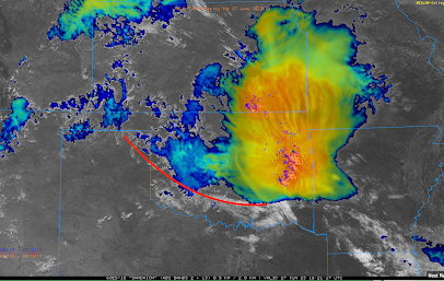
The meteorological question is: will the thunderstorms in southern Kansas this morning (now in eastern Kansas and Oklahoma as seen on the satellite image below (12:45pm). The red line is the collision between the extremely hot and unstable air to the south and the rain-cooled air to the north. It is going to have to change direction in Oklahoma and move back to the north for this system to -- unfortunately -- reach its whole potential.
There is a low pressure system in the upper atmosphere that was approaching the KS-CO border and was expected to arrive around 4pm CDT.
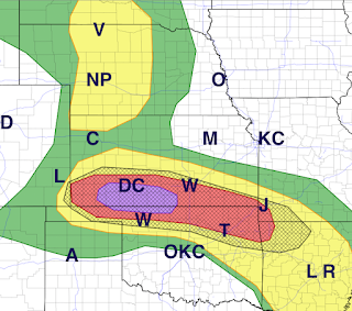
The area in purple has a high risk of winds of 60 mph or stronger. A "derecho" (an area of damaging winds that extends for more than 100 miles):
 Here is the color code:

FORECASTS
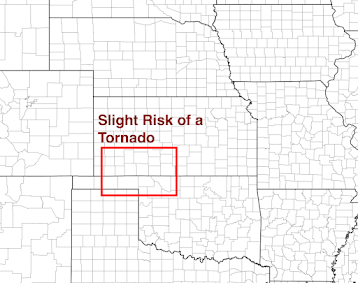
Because of the presence of the rain-cooled air boundary, there is a slight risk of a tornado in the area outlined in red.


- Purple is a high risk of winds of 60 mph or stronger. In addition to the highest risk of damaging winds, giant hail ≥ 2" may occur.
- Red is an enhanced risk.
- Yellow is a significant risk.
However, where you see the hatching, the forecast winds may exceed 75 mph.
Now is the time to prepare! Safety recommendations are below:
- Call friends and relatives to make sure they are aware of the threat, especially if they live in a mobile home.
- Make sure you have at least three ways of receiving storm warnings. Since the threat along and east of Interstate 35 will be at night, StormWarn is a great way to receive information. It worked great at 11:30 last Saturday evening when we had a tornado warning that included my home.
- If you live in a mobile home, you may wish to move spend time with a friend or relative when a tornado or severe thunderstorm watch is issued.
- Ask yourself what you would need if you were without electricity for five days. In some areas it will be longer, but five days is a good planning target. If you think I am exaggerating, some in northeast Oklahoma were without power for a week!
- Battery-operated fans for the same reason (it will be quite hot the next few days)
- In Houston, people died due to carbon monoxide poisoning due to misuse of generators after their windstorm last week. If you have a portable generate, make sure it is full of fuel but -- above all -- follow the manufacturer's instructions for use.
- If you have a chain saw, fill it with fuel.
- Check your tornado shelter. Make sure it has a couple of bottles of water and, if appropriate, diapers.
- Any essential foods or medicines should be taken care of immediately, well before the storms arrive.
- Have all of your devices charged but disconnect when you see the first lightning or hear the first thunder.
- Keep the kids in close communication.
- Bring in lawn furniture, trampolines or anything else that can blow away.
- Put the car in the garage.
- Pick any ripe tomatoes!
You can also follow more for more on Twitter @usweatherexpert.


Comments
Post a Comment