Posts

Showing posts from February, 2024

Exactly Why We Need a Natural Disaster Review Board

Image
We are six months after the Maui Wildfire and we still do not have any comprehensive answers regarding the cause of the fires, how lives could have been saved or best practices for recovery.  We do  have a report from the U.S. Fire Administration (image above) recommending better earpieces for fire fighters for better communications during high winds and other items. While I am sure those would be helpful, that doesn't come close to getting to the root(s) of the catastrophe.  Example after example shows our nation desperately needs a Natural Disaster Review Board modeled after the hugely successful National Transportation Safety Board. There are bills before both the House and Senate to create one -- but they do not seem to be going anywhere.  If you support this idea, please call your congresspeople or send them an email today! 

Congratulations, Tom Skilling!!

Image
Tom Skilling has retired after a stellar career at WGN-TV in Chicago. Tom has been everything that is good about television meteorology and I hope his retirement is as enjoyable as mine has been.  [I apologize for not having this out yesterday but our ATT modem blew out yesterday and they could not fix it until about a half-hour ago.]

Blizzard Conditions Starting in California, Updated 2:15pm PST

Image
A long-duration blizzard has begun in the Sierra.  As much as twelve feet of snow is forecast to fall with gusts above 80 mph.  Color codes: Orange = blizzard warning. Pink = winter storm warning. Gold = high wind warning. Brown = winter storm watch.  Purple = winter weather advisory. Dark Blue = winter storm watch  Magenta = wildfire warning. Gray = fog advisory. Radar at 2:05pm PST.  Snow has been falling in the Sierra much of the day. Chain laws are in effect on I-80 over the mountains.  The forecast radar for noon tomorrow.  Snow will fall through Saturday night and into Sunday. As much as 10-12 feet are likely.

"Twister" Behind the Scenes

Image
With Twisters  coming out in July, there has been a flurry of interest in the original. Above, you will find behind-the-scenes footage taken while shooting 1996's  Twister.  I found one shot really interesting. It is from the Wakita sequence (Jo's aunt) and it occurs at 12:27. You see a law enforcement officer carrying a baby.  Consider that, three years later, the F-5 tornado that struck Bridge Creek, Oklahoma, caused a baby to go airborne and missing for a considerable period of time. Then, an incredible stroke of luck.  Sometimes, life really does imitate fiction. 

Western U.S. Major Storm, Updated 5:20pm PST

Image
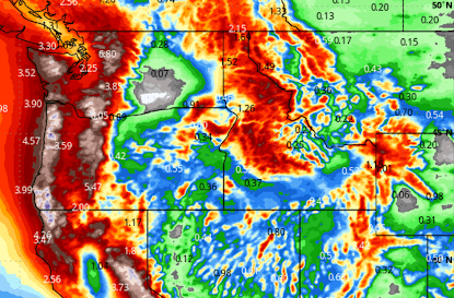
The Amount of Snow Has Been Increased to As Much as 12 Feet! -- original post -- Major Storm, Including Blizzard Conditions, in the West Wind Gusts to 100 mph and Snows of More than Ten Feet Are Likely Color codes: Orange = blizzard warning Pink = winter storm warning  Gold and Brown  = high wind watches/warnings  Green = flood watch Dark Blue = winter storm watch  Purple = winter weather advisory Light Brown = wind advisory  All travel in the Sierra should be completed by 9am tomorrow (Thursday) due to extreme snowfalls (more than 10 feet  in some areas) and high winds. That is why the rare blizzard warning is out. Radar at 12:22pm PST: Total Precipitation (rain and the moisture in snow) now until Monday morning: Note the 10+ inches of rain amounts on the California-Oregon border. More than ten feet  of snow is likely in the Sierra resulting in road closures including, perhaps, Interstate 80.  The precipitation is expected to continue beyond Monday morning.  

Recap of Last Night's Tornadoes and Texas Wildfires

Image
There were damaging tornadoes in multiple areas last night. The first of them were in northern Illinois, which then moved into Chicagoland. A number of the tornadoes caused damage.  Later, damaging tornadoes developed in Michigan and Ohio. Note: some of the wind reports (blues) of wind damage may have been associated with tornadoes. The tornado track from near Dayton to Columbus featured heavy damage. Some of the damage may be rated as high as EF-3.  Texas Panhandle Wildfires This was a giant, historic wildfire that will likely change the future of the region. It appears that dozens, if not hundreds, of structures have burned. The wildfire is 80 miles from west to east and it continues this morning. 

Note to Readers....

I called it a night at 1am. I had tracked tornadoes and wildfires since 9am yesterday. There were damaging tornadoes in northern Illinois and, likely, in Michigan during the night.  On the blog later today will be coverage of the historic fires in the Texas Panhandle and more. 

Tornado Watch Illinois, Indiana, Ohio, Kentucky

Image
The tornado watch is in effect until 6am EST. Please monitor the weather over this region the rest of the night. Turn on your weather radio, WEA or your GPS weather app. I am also tweeting  @usweatherexpert. 

New Watch: Great Lakes Region

Image
The watch is in effect until 5am EST. Note that "a couple of tornadoes are possible."

Tornado Watch for Chicago, Northern Illinois, Southeast Wisconsin, Iowa, and Far Northwest Indiana (Update 8:10pm)

Image
The watch is in effect until 10pm. Hail to 3" in diameter (baseball size), 70 mph and a few tornadoes, some of which could be strong.  Please follow me on Twitter @usweatherexpert  for additional information as the storms develop.  It is important to monitor local sources of weather information and make sure your tornado safety area is really to do. Always remember to wear shoes and put a couple of bottles of water and diapers in the area.  Note: if you are curious as to how tornado forecasts and warnings save lives, I've written a book on the subject.  Update 8:15pm:  There have been multiple tornadoes with this weather system. Here is an image of one, from Twitter.

Note to Readers....

... I am covering the sevrere wildfires on Twitter @usweatherexpert.  I will cover any tornado or other severe weather warnings on Twitter this evening, as well.

Quick West Coast Storm Update

Image
The map shows the forecast precipitation between now and 4pm PST Sunday. More than ten feet  of storm are possible in the Sierra with this storm. I -- strongly -- recommend that travel through the Sierra be completed before 11pm Wednesday.  Orange is a blizzard warning. Pink is a winter storm warning. Blue is a winter weather advisory. The gold and browns are high wind watches and warnings. 

Enhanced Risk of Strong Tornadoes, Damaging Winds and Giant Hail (Updated 3:10pm For Additional Tornado Risk)

Image
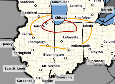
Please begin monitoring the weather in your area by 4pm if you are in one of these areas where tornadoes or severe thunderstorms are forecast to occur. [update, 3:10pm] National Weather Service says baseball-sized hail  may occur in the red outlined area along a strong tornado or two.  -- resume text-- In the Ohio Risk area, the chance of tornadoes and damaging winds will last well into the night.  Tornado Risk - Updated The yellow, hatched area has an enhanced  risk of strong  tornadoes. The brown area has a significant risk. Note a new era including far south Chicagoland to near Lafayette IN has been added to the strong tornado risk.  Damaging Wind Risk The red, hatched area has an enhanced  risk of damaging wind gusts of 75 mph or stronger. The yellow area has a significant risk. Power outages are possible.  Giant Hail Risk The hatched is where hail 2" or larger in diameter is forecast to fall. The red area, which includes Chicago and Milwaukee, has an enhanced  risk.

Critical Wildfire Risk Today

Image
The huge wildfire in the Texas Panhandle continues this morning. It is moving in the general direction of the town of Canadian. Huge area of high wildfire danger and high winds today. Orange is an elevated risk of wildfires, red is a critical risk. 

Today's Tornado Risk

Image
This post is out-of-date.  Please go here for the latest forecast, which includes strong tornadoes. https://www.mikesmithenterprisesblog.com/2024/02/enhanced-risk-of-strong-tornadoes_27.html The area in brown has a significant risk of tornadoes. The storms should begin after 4pm.  There is also a risk of giant hail in the hatched area.

Global Warming: The Heading Gives Away the Game

Image
Another attempt to make censorship pertaining to global warming legitimate. Other sciences don't have "political science" appended to their search engine terms. And, that is because (I estimate) 80% of what we hear about climate these days is political rather than genuine science.   Since Michael Mann won his case against Mark Stein, which I expect to be reversed on appeal, the number of articles like the one above has probably quadrupled. We must never surrender our First Amendment rights for global warming or any other reason. 

Don't Allow Yourself to Be Taken In!

Image
Propaganda from "CanopyPlanet" like this is pure gaslighting..  My response: Wind farms and utility-scale solar? Wasteful, unreliable and a poor use of resources. And, the wind turbines and solar panels are wearing out far  faster than projected .  Nuclear, hydro and next-generation nuclear = smart.  Don't fall for the propaganda!!

Major Storm to Affect West Coast Then Central U.S.

Image
There are two storms (#1 and 2) near the coast that will move inland bringing rain -- snow in the higher elevations -- to the West.  Storm #2 is racing east and will help trigger severe thunderstorms with a risk of tornadoes late Tuesday . Storm #1 is causing rain in Southern California today that will continue into tonight.  Storm #3 looks like a monster with extreme mountain snow and, in places, flooding rains in the West. Severe thunderstorms are possible in the Great Plains. Blizzard possible in the Rockies and/or northern Plains.  Here are details. These are the precipitation maps from 4pm this evening to 10pm Sunday.  Warnings are already going out about 6 to 9 FEET of snow in the Sierra Friday and Saturday. It is too soon to get specific as to where the severe thunderstorm, and possibly tornado, threat may develop. I will cover that beginning about Thursday. I'll start covering the blizzard threat on Wednesday. 

Tornado, Hail, and Wildfire Forecast for Tuesday [Updated, 4:45pm]

Image
There is a significant risk of tornadoes tomorrow in the Midwest after about 4pm. The first of the severe thunderstorms will probably develop over Illinois. The area in orange has a significant risk of a tornado. The area in red, which includes Chicago, has an enhanced risk.  There is also a risk of giant hail -- two inches or larger -- in the hatched area. In the remainder of the yellow area, there is a significant risk of 1" or larger hail. There is also a critical wildfire risk of wildfires in the red area over the southern High Plains.  Of course, I will update on these risks tomorrow. 

Extreme Precipitation in the West This Week

Image
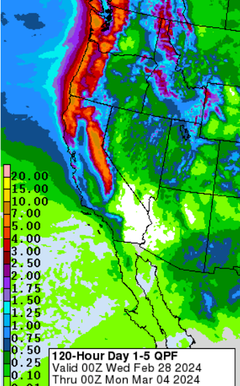
A major pattern change will occur this week this week bringing heavy rain and heavy snow at higher elevations.  Above are forecast rain and the moisture content of snow for this week. The amounts will likely be sufficient for localized flooding in the areas where it is not in the form of snow -- especially in California.  Below are the forecast snow amounts for the week. If these forecasts are correct, it means that the snowpack will be greatly improved infall of these areas.  A cold front the first of the week will usher all of this in. Here is a timing forecast. Please take these forecasts seriously and factor them into your plans. 

Religious Freedom in Peril

Image
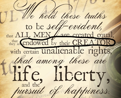
While we enjoy posting our "Sunday Fun" features, this is a serious post on the day of the week when Christians traditionally worship God.   You will find information on the bill before Canada's Parliament here . Twenty years ago, no one would have dared introduce such outrageous legislation. Now, among the Canadian and US's 'intelligentsia,' this type of thinking is becoming mainstream. As we have seen with the -- sometimes violent -- protests against Israel in recent weeks, many 'progressives' in the USA are increasingly hostile to the Judeo-Christian ethic that has been the backbone of our nation for 248 years.  To give you a second example from last week, someone named Heidi Przybyla, posted the item below and repeated it -- several times -- on MSNBC. Keeping in mind  there is no such thing as "Christian Nationalism ," this is an attempt by MSNBC and Democrats to influence future events by creating a slur!  With the political purpose of t

Sunday Fun: Which Livery for the New Air Force One?

Image
I'm curious what readers think. The new Air Force One is being built. Which livery (paint scheme) do you prefer? Please make your preference known in the comments.  We'll call them "traditional" and "red, white and blue." 

Carrington Event: Time to Pay Attention!

Image
From the very beginning of this blog, we have warned of natural hazards like ice storms, tornadoes, tsunamis and others. And, since at least 2011, we have warned of a Carrington Event or an electromagnetic pulse bomb in the upper atmosphere -- either of which would take out the electric grid...likely for weeks or months.  A number of publications have written about the mass cellphone outage the last few days have written about this topic . But, here's the problem: Presidents Obama and Trump appointed commissions to study this truly existential problem and recommend solutions. But, then, little happened.  So the question is: Will the United States wake up and fortify the grid before the next Carrington Event occurs.  And, will you put away at least a week of water and food (that won't spoil) away?

Global Warming: Is There Anything It Can't Do?!

Image