Thursday, March 30, 2017
Here is Some Very Good News for the United States
Occasionally, Congress does exactly the right thing and that is the case with a new bill that should soon become law that will improve weather forecasting and storm warnings in the United States.
Update on Rainfall Amounts
Here are the amounts for the last 24-hours.
Rainfall amounts since the pattern changed.
And, here is the forecast rainfall for the next seven days.
Rainfall amounts since the pattern changed.
And, here is the forecast rainfall for the next seven days.
Less Ominous Tornado Forecast
Normally, with this forecast, I would be cautioning you about the tornado risk. And, I will do that. But, the serious risk of violent tornadoes that was forecast yesterday has been downgraded. Whew!
The 5% (brown) area is a significant risk for tornadoes. So, you will monitor the weather at the first sign of the approach of a thunderstorm. Do that and you should be good to go.
The Blizzard of '57
Fifty years ago this past week was one of the worst blizzards in the history of the Great Plains. Terrific article here: And, yes, I remembered it from being a boy in Kansas City.
Of course, as I marveled at the huge drifts, little did I know the event that could completely change my life, the Ruskin Heights tornado, was eight weeks away.
Wednesday, March 29, 2017
Overnight Tornado Watch in the South
I hate these. Tornadoes are four times more deadly in darkness than they are during daylight, especially after the 10pm hour when most people go to bed.
So, now might be a good time to load the AccuWeather app (and, place your phone next to your bed) on your cell phone or to subscribe to WeatherCall or, better still, both.
This ends my weather coverage for today.
So, now might be a good time to load the AccuWeather app (and, place your phone next to your bed) on your cell phone or to subscribe to WeatherCall or, better still, both.
This ends my weather coverage for today.
Tornado Watch Kansas and Missouri.
Note there is a moderate risk of strong tornadoes. The watch includes the Kansas City area south of I-70.
Dangerous Tornado Day Thursday
While we have a significant tornado risk later today (see below), we have another serious risk tomorrow.
On this particular map 15% (yellow) is the significant threat threshold. The forecast probabilities are considerably higher than that. The hatched area is where violent tornadoes are expected which includes both Nashville and Memphis.
So, what should you do at this point?
On this particular map 15% (yellow) is the significant threat threshold. The forecast probabilities are considerably higher than that. The hatched area is where violent tornadoes are expected which includes both Nashville and Memphis.
So, what should you do at this point?
- Make sure you have at least two, independent, sources for tornado warnings. I recommend the AccuWeather smartphone app and WeatherCall. They will give you the warnings for your home (or other selected location) with a few false alarms as possible.
- Have a system for your children and infirm friends and relatives to get the warning quickly and get to shelter in seconds.
- If infirm people need help getting sheltered, go pick them up before thunderstorms approach. Do NOT try to get to them after a tornado warning is issued.
- Make sure your phone and laptop are fully charged.
- Won't hurt to make sure you have some extra cast and a full fuel tank for your car.
- Make sure your generator is full of fuel and working properly.
Reminder: I provide real-time storm information -- based on good science and without hype -- on Twitter @usweatherexpert .
Of course, I will update this blog on today's tornado threat later today and on tomorrow's threat tomorrow morning.
How Much Rain Has Fallen? Answer Here.
Eight days ago we talked about the change in weather patterns that would allow drought-easing rains to occur in the Great Plains. Here is the latest 24-hour rainfall map.
And, here is the cumulative rainfall since the change in pattern occurred. Please note the different color scale.
And, there is more rain to come. Here is the National Weather Service's 7-day rainfall amount forecast.
The computer models nailed the change in pattern. When we get to ten days from the first forecasts I posted, we'll go back and see which computer models produced the most accurate forecasts.
Dangerous Tornado Days Ahead
Dislike having to focus the blog on tornadoes so much, but it is necessary in this case.
Yesterday was extremely prolific day for tornadoes with at least 15 of them in west Texas. Today, the threat is at least as high only we must add in the threat of violent tornadoes in areas with higher population density.
The brown area is the significant tornado threat. The yellow is an enhanced threat of tornadoes. The hatching, which includes Branson, Ft. Smith and Little Rock, is where violent tornadoes are forecast to occur.
And, tomorrow will be at least as bad, only farther east. I'll have an update on that when later data comes in early this afternoon.
Tuesday, March 28, 2017
Tornado Update
There have been numerous reports of tornadoes, numerous reports of large hail and a report that 2-3 storm chasers died in a traffic accident this afternoon.
Here is the radar at 5:36pm.
The red polygons are tornado warnings and the yellow polygons are severe thunderstorm warnings for damaging winds and hail. The tornado watch (below) continues in effect.
Here is the radar at 5:36pm.
The red polygons are tornado warnings and the yellow polygons are severe thunderstorm warnings for damaging winds and hail. The tornado watch (below) continues in effect.
Amazing Time-Lapse:
This gorgeous video, from storm chaser Chad Cowan, shows a supercell that appears to produce a tornado, get overrun by a line of thunderstorms. The video was taken over the Black Hills of South Dakota.
Supercell Merger - 4k StormLapse from Chad Cowan on Vimeo.
Tornado Watch: Texas and Oklahoma
Please note that there is a "moderate" chance of a strong tornado. There is also a moderate chance of hail at least two inches in diameter.
Another Serious Tornado and Hail Risk
Here we go again.
We have an enhanced risk of tornadoes today.
The 5% area (brown) is the significant threshold for tornado risk with includes Oklahoma City and the DFW Metroplex. The 10% area includes Wichita Falls and Lawton. It is important that people in these areas monitor the weather at the first sign of the approach of a thunderstorm. The AccuWeather App does an excellent job at providing severe weather warnings for your location.
Very large hail is also likely -- a repeat of Sunday only farther west.
On the hail map 15% (yellow) is the significant threshold. As you can see, there is a high risk of thunderstorms producing large hail in the 45% area. The hatching means hail could exceed 2 inches in diameter! Needless to say, put your car in the garage along with anything else you wish to protect.
I'll update on these risks later today.
Monday, March 27, 2017
Rainfall Forecasts 8.5 Days Out
Here is one more set of model forecasts of rainfall amounts. In this case, I am showing 8.5 day forecasts because the last 1.5 days of the forecast runs are shown to be more or less dry.
GFS Forecast
CMC Forecast
Below, I show how much rain has already fallen during the change in weather pattern from dry to wet. And, yes, nine days from now I'll post graphics to show how accurate the forecasts were (or were not).
GFS Forecast
CMC Forecast
ECMWF Forecast
Below, I show how much rain has already fallen during the change in weather pattern from dry to wet. And, yes, nine days from now I'll post graphics to show how accurate the forecasts were (or were not).
How's That Rain Coming Along?
Here is the rainfall for the 24 hours ending at 7 this morning.
And, here is the precipitation since the change in weather pattern began:
More is on the way! Updates later this afternoon.
And, here is the precipitation since the change in weather pattern began:
More is on the way! Updates later this afternoon.
Tornado Risk Today
Unfortunately, we have another day with a significant tornado risk.
The 5% (brown) area is the significant threshold. This includes Memphis.
Please keep up on the weather in this area later today.
I suspect I'm going to be posting one of these for Oklahoma and Texas tomorrow. Stay tuned.
Some Thoughts From Another Climate Scientist
Dr. Roy Spencer just wrote, pertaining to global warming,
His entire column is here. And, yes, Greenpeace has admitted they do not tell the truth.
Why has the public lost interest? The reasons are many.
For example, most of the world’s population experiences many tens of degrees of natural temperature variation, yet they are asked to fret over two degrees of warming on time scales so long almost no one would notice it in their lifetime. The observed rate of warming has been about half of that predicted by the average climate model, and the climate model average is what guides energy policy.
Furthermore, the models do not produce realistic natural climate variability without considerable fudging and tinkering to fit the observed temperature record. As a result, we really aren’t sure recent warming isn’t partly or even mostly natural in origin. (Our study of ocean warming since the 1950ssuggests about 50% each)...
My opinion tends toward the little-impact end of the spectrum [of global warming's effects]. I suspect that future warming will be slow and relatively benign (say, 1.5 deg. C by the end of this century), severe weather events won’t become demonstrably worse, and slow sea level rise will continue roughly as it has for centuries. People will adapt to whatever slow changes occur.
And renewable energy (or maybe safer nuclear energy) breakthroughs will come from the private sector and market forces, not from legislative fiat.
Sunday, March 26, 2017
The Hail Was as Bad as Forecast
Tornado Watch Just Issued For Oklahoma and North Texas Until 11pm.
A tornado watch has been issued for parts of central Oklahoma and north Texas (the Dallas-Ft. Worth Metroplex is included) until 11pm.
The area I'm most concerned about for tornadoes is from around Pauls Valley in southern Oklahoma to around Gainesville in northern Texas and one county on either side.
The first thunderstorm is developing southeast of Duncan, OK. on the 4:07pm radar. It should begin moving northeast.
The area I'm most concerned about for tornadoes is from around Pauls Valley in southern Oklahoma to around Gainesville in northern Texas and one county on either side.
The first thunderstorm is developing southeast of Duncan, OK. on the 4:07pm radar. It should begin moving northeast.
Sunday: 2pm Severe Weather Update
Dear Readers,
I continue believe (see below) that there will be tornadoes and severe thunderstorms with very large hail as indicated below.
I don't expect anything major before 3 to 3:30pm, so if you want to ran an errand in the affected area, now is the time to do it. After that time, please keep up on the weather at the first sign of a thunderstorm's approach.
I'll update again when I think things are beginning to develop.
Mike
Major Hail and Tornado Threat
While it is in a geographically concentrated area, there is an important tornado and very large hail threat in parts of Oklahoma and Texas.
Tornado
From the Kansas border to the Dallas-Ft. Worth Metroplex, there is a significant chance of tornadoes with an enhanced chance in southern Oklahoma from around Norman to just south of the Red River. I recommend people in this region pay attention to the weather later today.
Very Large Hail
It is a "put your car in the garage day"!
The significant threat level on this map is 15% (yellow) and, as you can see, the threat is 45% from near Perry to DFW. The hatching means the hail could be larger than 2 inches.
I'll update on these threats later today.
Sunday Fun: A Bonus From the California Rains
In addition to ending the drought and fixing the water crisis (and, yes, creating some soggy salads), California will greatly increase hydroelectric power. This means zero carbon emissions at no cost and cheaper energy for the Golden State.
Saturday, March 25, 2017
How Much Rain Has Fallen So Far?
Here we are, into the third day of the extended period of rain for the Great Plains. The rainfall amounts, so far, are below.
The yellow areas have had more than two inches. There is a tiny spot in eastern Colorado with three inches. Of course, my house had 0.08 inches.
More rains to come.
The yellow areas have had more than two inches. There is a tiny spot in eastern Colorado with three inches. Of course, my house had 0.08 inches.
More rains to come.
By Definition, If It Isn't Reproducible, It Isn't "Science"
Reproducibility shouldn't give them a second thought. It should be in their figurative DNA. That is, unless they are advocates rather than scientists.
Friday, March 24, 2017
Amazon Running Low
It has been a very good week for sales of Warnings. Amazon is running low.
It is now up to 60 reviews and they continue to be stellar.
All six reviews at Barnes & Noble are five-star.
If you combine the ratings, it means that 89% of the reviews are 5-Star and 9% are 4-Star. Not bad!
The bad/mediocre reviews come from meteorologists and meteorology students who, unfortunately, expect a textbook-type experience rather than a great story about how the (still, unfortunately) under appreciated storm warning system came to be and how lives get saved every month by this amazing system.
So, if you are looking for a great book. Click on the green link above. You'll really enjoy it!
Attention Gardeners, Farmers and Ranchers
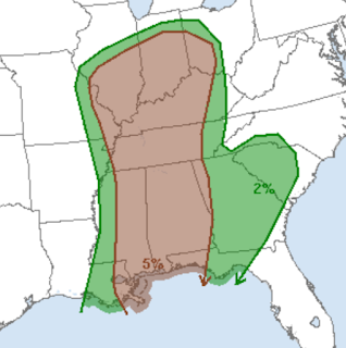
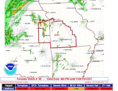
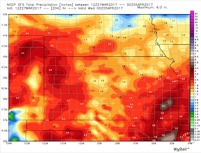
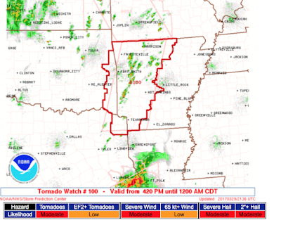
Here is the regional actual precipitation from the time it began in Colorado about 30 hours ago.
Forecasts
Okay, because we are now in planting season (soil temperatures rising) and I personally know people who are planning to garden this weekend, here is another update on rainfall prospects for the next ten days.
GFS Model Forecast for Ten Days
For reasons not well understood, the GFS typically is drier in its Great Plains forecasts produced from the morning data which again seems to be the case here. The other two models have turned wetter compared to last night's and yesterday's forecasts.
CFC Forecast
Yes, that is an 8+" area in northwest Kansas. Do not take any of the specific details of these forecasts too literally as illustrated below.
ECMWF Forecast
The ECMWF has forecast, like the CFC, some excessive rainfall in Kansas. But, this time, their forecast is for it to occur in the southern Flint Hills rather than northwest Kansas.
Again, do not take the details literally. The takeaway from these forecasts is that moderate to heavy rains will fall over most of this area the next ten days.
ECMWF Regional
Because the ECMWF is the usually the best of the three, here is the latest rainfall forecast for the entire region for the next ten days.
So, gardeners, farmers and ranchers -- use this information in a way that is most useful to you. The great news is that the long-forecasted rains have arrived and will continue for a while!
The Tornado Risk Has Increased a Bit
Five percent is the significant threshold. Ten percent, which includes Shreveport and Lufkin, means to really keep an eye out.
Thunderstorms are also forming (right now along the KS-OK border). There is a slight chance of a weak tornado or two (a/k/a, "landspouts") if the storms can interact with the upper atmospheric low pressure system.
These storms are moving almost straight north.
Thunderstorms are also forming (right now along the KS-OK border). There is a slight chance of a weak tornado or two (a/k/a, "landspouts") if the storms can interact with the upper atmospheric low pressure system.
![]() |
12:25pm CDT Radar |
If All You Have Is a Hammer, Everything Looks Like a Nail
Al Gore's latest attempt to stay in the news.
If you want to kill brain cells by reading the article, it is here.
Rain Amounts on Day One
Here are the rainfall amounts from yesterday afternoon and evening's showers and thunderstorms.
ADDITION: Close-up of amounts.
Thursday, March 23, 2017
Subscribe to:
Posts (Atom)