Wednesday, August 31, 2022

Weather As Fascinating to Read as to See

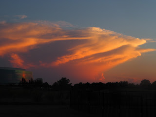
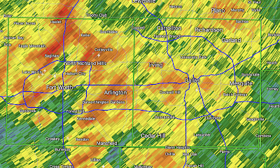
As I was standing in my backyard in Wichita photographing this Oklahoma thunderstorm Sunday evening, I thought again how fascinating and challenging the weather is. Below is a photograph of the radar of the same storm. 
Left is the reflectivity data, the type of radar you see on television. At right is the wind data, showing the diverging winds of a downburst. This thunderstorm was 78 miles from my home. 
When I started my career, we didn't know downbursts existed, let alone did I think we would have a tool to detect them (image at right with diverging arrows).

I tell the amazing story of our progress in warning of tornadoes, downbursts and hurricanes in Warnings: The True Story of How Science Tamed the Weather
This book reads like a novel even though it is completely true. 
"Goodreads"
Pick up a copy. I think you'll enjoy it. 

Tuesday, August 30, 2022

This is a Terrible Headline

This headline is both sensational and misleading:
The story is here. The "storm of the season" quote does not appear in the article nor is there any meteorologist on the record forecasting a major hurricane, let alone one that will "ruin Labor Day."

While such an occurrence is not impossible, I would rate the odds of a "major" hurricane striking the United States this weekend at about one in 50. The chance is so small that at this point that I am not putting in my advice to "keep an eye on the official advisories."

The bigger point is that this is just reprehensible journalism. 

Shipping Electric Car Fuel

Amen!

And, remember, you can triple the number of windmills but if the wind is calm the amount of electricity they produce is still zero. 

Monday, August 29, 2022

Midwest: Damaging Winds Likely Today

In the red area, there is an enhanced risk of wind gusts of 60 mph or stronger. In the hatched area, the gust potential is 75 mph or stronger. This includes Chicagoland. 

In the yellow area, there is a significant risk of gusts of 60 mph or stronger. 

This situation is developing rapidly. Please keep up on the latest weather information throughout the day. 

Wait, What?! A Carbon Dioxide Shortage?

Last time I checked, we were trying to get rid of carbon dioxide. Now, there's a shortage. The latest, here

Sunday, August 28, 2022

Sunday Fun

I always thought they were in the sky. Evidently, they are in west Wichita. 

Friday, August 26, 2022

Landing Amateur Rockets Like Space-X

This an interesting video in its entirety but I've cued it up to where he starts rocket launching. He tried to launch rockets and then land them like Space-X. Enjoy!

Thursday, August 25, 2022

World Population Growth Rate

I thought this was interesting and you may, too. World population growth is decreasing and that trend is forecast to continue. 

Wednesday, August 24, 2022

Lenny Has "Matriculated the Ball to Heaven"


Len Dawson passed away this morning at the age of 87. As one person at Instapundit put it, he has "matriculated the ball into Heaven." 

That famous line (video above) by Chiefs' coach Hank Stram (the first person ever to be mic'd during a NFL game) was spoken during Super Bowl IV, which the Chiefs won 23-7. Len was MVP. Not only did he win the game, he cooly and professionally handled utterly false charges of gambling that were thrown at him the week before the game in an attempt to influence the outcome. 

If you wish to see the highlights of that amazing game, in which the Chiefs were a huge underdog, they are cued up here (the NFL won't let me embed them). I highly recommend this version because it is pure football (no politics or political correctness) and they are narrated by John "frozen tundra of Lambeau Field" Facenda. 

But Len wasn't just a Hall of Fame quarterback, he was terrific man. Just read these testimonial comments about him published in the Kansas City Star. 

As I mentioned when it was announced that he had entered hospice care, I met Lenny for the first time when I was doing the weather for KMBC Radio and he was doing sports for KMBC TV and Radio (photo from that era below). We remained friendly throughout our lives. 

My Dad was a Chiefs' Red Coater for decades.
Among other civic duties, the Red Coaters welcomed the Chiefs onto the field before every home game and, if I recall correctly, before the start of Super Bowl IV in New Orleans. 

I lost my Dad in January 2020. I am certain that Dad, Hank Stram, and Lamar Hunt were at the gates of Heaven this morning to welcome Len. 

Attention Meteorologists and Climatologists

Suppose you were in this crash...
And, while the paramedics were putting the seriously injured you into the ambulance, an attorney ran up and tried to shove a business card into your (broken) hand and started to explain all the grounds you had for a lawsuit: improperly maintained road, poorly designed air bags, et cetera. Would you appreciate the attorney's actions?

Now, let's assume that, instead of an attorney, it was a meteorologist who ran up to you on your gurney and told you all of the ways that climate change contributed to the accident. Do you think he would win any friends? Or, would it be better to wait until the crisis was over?

During yesterday's fatal flash flood in Dallas, a number of meteorologists began tweeting about the alleged relationship between global warming and the flash flood -- even as, simultaneously, news reports were explaining that people were being pulled out of cars. 

To me, these are mildly unseemly, not because of their message, but because of their timing. It is similar to the ambulance chasing attorney. While the event is in progress, the focus by meteorologists should be accurate warnings and followups and, by everyone else, getting those needing rescue and medical attention taken care of. 

This is especially true since a correlation between global warming and more flash floods is not accepted by the Intergovernmental Panel on Climate Change (IPCC). The IPCC is considered the "gold standard" on the topic. 


IPCC’s 2022 report says in its "North America" section (p 1938):

Observed trends in extreme precipitation events are more difficult to detect with confidence, because the natural variability of precipitation is so large and the observational database is limited. 

They even highlight the above in yellow. You can find the entire section here.  


The U.S. National Climate Assessment comes to a similar conclusion:


However, in U.S. regions, no formal attribution of precipitation changes to anthropogenic forcing has been made so far, so indirect attribution of flooding changes is not possible. Hence, no formal attribution of observed flooding changes to anthropogenic forcing has been claimed. [bold type theirs]


Finally, per Dr. Roger Pielke Junior's peer-reviewed work, U.S. flood damages are a tiny fraction of what they were eight decades ago when measured against the U.S. gross national product. 

Since the hypothesis that climate change has increased flash floods is not accepted, it is hard to understand what weather scientists accomplish by the "rush to tweet" while these events are in progress. I strongly recommend we cease doing it. 


To be clear, I do not object to a scientific discussion after the event is over, even if the science is not generally accepted. That is how science advances. But, I believe we should stop with the rush to tweet while hydro-meteorological disasters are in progress. 

Tuesday, August 23, 2022

More National Weather Service Warning Issues

Winterset, Iowa, fatal tornado, March 5
On March 5, as strong to violent tornadoes roamed the Iowa countryside, National Weather Service (NWS) tornado warnings were delayed by as much as nine minutes due to a cable cut in .... Dallas. 


The red rectangles indicate the radar is out of service.
The radar data shown as from a radar 100+ miles away.
Yesterday, and the day before, as much as 15 inches of rain fell in Dallas with severe flooding and the loss of at least one life. Because of a NWS data outage, warnings for Dallas had to be issued by NWS offices as far away as Nashville. This outage affected the NWS radar and both of the Federal Aviation Administration radars. 

Addition: 9a Friday:
In addition to at least one death, six billion dollars in damage -- and the local storm warning infrastructure failed completely!

Original Article
Even worse: additional Texas radars were out of service for reasons unknown yesterday. 
Issuing warnings during periods of life-threatening, extreme weather is the very core of the National Weather Service's mission, yet these issues occur with increasing frequency. 

In between March 5 and August 22, this blog has documented the too-numerous issues with National Weather Service warnings and infrastructure. There is no sign that anything is being done to address these systemic issues.

The National Weather Service's WSR-88D radars are more than 30 years old -- with no plans to replace them. Their communications network is increasingly failing. As readers know, I believe our nation desperately needs a National Disaster Review Board to help solve the too-numerous issues with the NWS, FEMA and other agencies and organizations key to disaster response and prevention in our nation

Monday, August 22, 2022

Note to Readers...

 ...I'm working on a couple of pieces that will be posted tomorrow or Wednesday. 

The Heavy Rains Have Ended in the DFW Metroplex

Here are the Dallas rain amounts and the highest was 15.3 inches about five miles east of downtown. 

The flood has caused major problems.

Below is a map of rainfall amounts for the entire Metroplex for the past 24 hours. 
There are a lot of aspects about this event that we will be discussing over the next two days. 

Bright green = flood warning. Magenta = flash flood warning. Dark green = flood watch. 

10:30am DFW Flooding Update

Here is the radar data at 10:25am. Moderate to heavy rain continues to fall throughout the Metroplex.

Extreme rainfall amounts have occurred, especially in east Dallas. As of 10:26 am, as much as 14.46 inches has fallen in the east part of the city. 
I am not able to update coverage until this afternoon. However, this is a major flash flood situation. 

Major Flash Flooding in DFW Metroplex

Headline From NWS Extreme Rainfall Message at 9am


Above is the 24-hr rainfall for Oklahoma, Texas, Arkansas and Louisiana. 

UPDATE: 9:46am: More than 13 inches has fallen in east Dallas.


Below is the DFW Metroplex's rainfall with more than 10 inches in east Dallas County and more than six inches in Tarrant county. Heavy rain continues to fall. 

The heavy rain will move into Louisiana as this map of forecast rainfall through 7am indicates. 

Sunday, August 21, 2022

Flash Flood Risk to 7am Monday

The red area has an elevated risk of flash floods the rest of the night. 

Whatever you do, don't try to cross flooded area by foot or by car!

Sunday Fun

We have a (literally) fat cat that roams our neighborhood. Lately he/she has found the goings on in our home to be fascinating. 
We aren't pet people but we assume the cat is adopting us rather than the other way around. 


Friday, August 19, 2022

3:45pm Update on South Central Flood Risk

The National Weather Service has further raised forecast rain amounts in Texas and immediately adjoining areas. The map is valid until 7pm CDT Friday, the 26th. 
The gold area in north (including the DFW Metroplex) and parts of central Texas is where seven inches or more are predicted to fall. In addition, I would forecast 3"+ in the Lubbock and Plainview areas and from there to the New Mexico border, a little farther west than on the map. 

I also believe amounts may be heavier in southwest Louisiana than indicated on the map. 

As to timing, significant to heavy rains will start in west Texas during the pre-dawn hours Sunday. 

The image below is the forecast radar for 1am Monday. I believe it is a reasonable representation of the rain pattern at that time. The rain will become more widespread on Monday. 

Intermittent rain and thunderstorms will become more numerous over Texas and Louisiana more or less throughout next week. 

Regardless of the current drought, if you live in a flood-prone area I would make sure to have a "go kit" ready by Sunday afternoon.

Whatever you do, do not cross flooded areas by foot or by car!

Update on Flood Risks

Here is the flash flood risk map from now until 7am Saturday.

The flash flood risk map from 7am Saturday to 7am Sunday. 

Do not try to cross flooded areas by foot or by car. 

The risk of flooding in Texas and adjacent areas of Oklahoma, Arkansas and Louisiana is high to extreme. 
The gold colored area in Texas has an extreme risk of flooding. Some spots could have more than ten inches. The heavy rains will begin in west Texas early Sunday and will spread to the east. Please prepare if you live in a flood-prone area. 

Thursday, August 18, 2022

Flood Threats in Texas and the Southwest

We have two areas where serious flooding may develop over the next seven days. 

The first in the Southwest. This forecast is from the NWS and the highest risk of flooding rains is from 5am Friday through noon Sunday. 

Later in the seven day period is when torrential rains forecast to occur in Texas - Arkansas - Louisiana. 
The area of gold within the orange are where seven inches or more are forecast to fall from Sunday morning through Thursday. Additional heavy rains may fall even beyond this seven day period. This the time of year when serious flash floods can occur in this region. I'll update these forecasts over the next few days. 

If You Like Reading About Weather...

...I post articles at Survive-A-Storm's site

Wednesday, August 17, 2022

The Future of Southwest Kansas and the Beef Industry

David Condo, author of a 2021 two-part story about Garden City and how a beef packing plant caused a boom in jobs and a doubling of population. The first part of the story is here. The second, here. The stories brought the author an Edward R. Murrow award.

I'm chiming in because of the question about the water needed for the plant drying up. Right now, the water comes from the Ogallala Aquifer. The author says the water will run out in "decades." Perhaps. 

But, consider this: the long term precipitation trend in Finney County, Kansas, is up -- and, rather significantly -- at 0.19 inches per decade. 
While temperatures are also rising, at least in the short-term, this increase in precipitation may decrease the load on the aquifer and allow the water to last longer than might be thought. 

Let's hope. 

Tuesday, August 16, 2022

Flood Risk Next Five Days

Here is the forecast of rainfall amounts until 7pm CDT on the 23rd. Where you see the ≥ 5" amounts in Arkansas and in Arizona and New Mexico is where flooding is likely to occur. Please monitor this situation. 

Global Warming: Is There Anything It Can't Do?!

Sheesh!

What might be true is that air conditioning keeps kids indoors in summer. I grew up in Kansas City without air conditioning and we were outdoors constantly in the summer. I did an online search but didn't find a study one way or another.

Sunday, August 14, 2022

Global Warming Is Not Needed to Produce a California Megaflood

Big Climate is cranking out the press releases as they vie for the big dollars from President Biden's climate bill. The latest generated headlines about a $1 Trillion flood in California made possible by global warming. 

There is a genuine threat of a trillion dollar flood in California and it isn't necessary for global warming to play a role. I wrote about this threat on November 5 of last year after reading a historical article in Scientific American. 
All that has been done by the UCLA researchers is to take the 1862 disaster and superimpose it on today's dense population and huge growth of wealth in the state. As to the increasing temperatures causing heavier rates of rain in California, that is the result of a computer model and there is hardly enough data to confirm this is truly the case. 

The study is useful as an exercise as to which areas of the state are most vulnerable when the next megaflood occurs. Plus, I continue to worry that there is far too little preparation for when the next hurricane strikes Southern California. 

But, it is unnecessary for global warming to occur in order for California to experience a major flood. 

Sunday Fun: Wisdom From Blackwell

From Cicarella's Super Pizza in Blackwell, Oklahoma. 

Excellent advice. And, their pizza and salad bar are quite good!

Saturday, August 13, 2022

Very Sad News

Len in Super Bowl I; photo NY Post
The news that broke today that Len Dawson is in hospice care makes me very sad. 

Not only was Len a Hall of Fame Quarterback for the Chiefs, he was one of the first active players -- ever -- to do sports broadcasting. 

I met Len when he was sportscaster for KMBZ Radio in Kansas City and I did their weather. Even though I was a teenager, he was always a gentleman and encouraging to me. In the last couple of decades, I would run into him at KMBC TV and we would have a pleasant conversation. While I haven't been him recently, I considered him a friend. 

Best of luck, Len. You will be terribly missed. 

Multi-Angles of the Challenger Disaster

Some of us will never forget watching the live telecast of the Challenger launch with the teacher-in-space program and the horror we felt when it exploded. 

I ran across this the other day and it is what the NASA television director was watching during the launch with multiple camera angles. The director did an incredible job directing the camera operators and taking the shots. 

Thought you might find it interesting, also. 

Friday, August 12, 2022

Flying -- Then and Now

Yesterday, I reviewed the River Spirit Resort and Casino where Kathleen and I went to celebrate our wedding anniversary. We decided we didn't want to fly. These days, the photo below summarizes how I feel when flying -- not to mention the delays, gate changes, et cetera. 

It doesn't have to be this way!

On our honeymoon we went to Hawaii on "747 Braniff Place" (the airlines in that era named their planes similar to cruise ships). The experience in coach was better then than today's first class. 

This is the section in which we sat. Look at the leg room! The group of seats in the middle was five-across. Before they retired the 747's, most airlines were seven-across. 
We were offered the choice of three hot entrees for lunch. Then, a couple of hours before landing, they set up a buffet in the back! Everyone was courteous and pleasant. 

But, many say, "without deregulation, people could not afford to fly." I take issue with this. The airlines today have access to all types of improved productivity tools (computer reservation systems, for one) that makes their cost of doing business less. 

Since 747 Braniff Place's coach service was much better than today's first class or business class to Hawaii, let's compare prices. First, we'll compute inflation. 
I paid $250 for each of us, round trip. That's $1,640 today. 

Since Braniff no longer exists, let's look at going through Dallas to Hawaii today on American Airlines.
Yes, today's hugely inferior coach class is less expensive when compared to inflation-adjusted dollars. But, look at the prices for today's business class ($6,090) and first class ($3,730) with a far inferior product to coach in the 70's. 

While I give huge kudos to the improved safety as compared to the 1970's, there is no reason at all for the chaos of flying today nor the greatly inferior in-flight comfort and service. 

I'm not a person who longs for the "good old days," except in this one aspect of life. Today's airlines are awful when compared to the 70's and 80's.