More than two million homes and businesses are without power at this time = more than 5,000,000 people.
It will be weeks before all of the power is restored. Friday, September 30, 2022
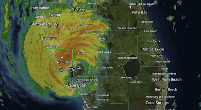
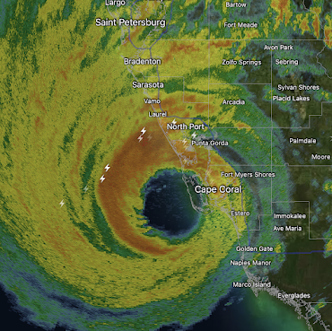
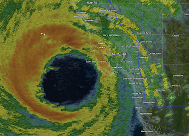
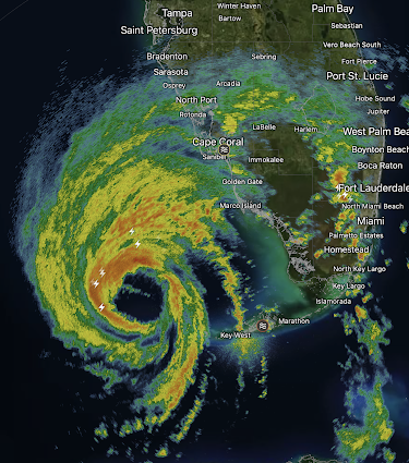
Florida Damage Estimate From Ian
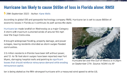
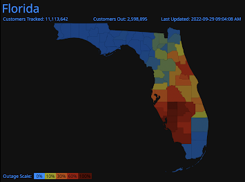
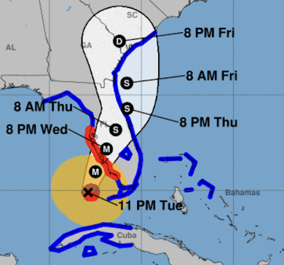
A number of people have asked me how much damage Ian caused in Florida. Here is an estimate. The full article is here.
Hurricane Ian Restrengthening as it Approaches Coast
Above is the radar from 12:06pm. The center of Hurricane Ian is moving slightly north of west. The pressure has dropped two millibars in the last couple of hours. The National Hurricane Center says its maximum sustained winds are 85 mph. It is possible the wind could strengthen just a bit before it makes landfall. The winds are more spread out than usual for a hurricane.
- H = hurricane.
- D = tropical depression (< 40 mph winds)
- Amber = winds stronger than 40 mph.
- Brown = hurricane force winds ( ≥ 75 mph)
- Red = hurricane warning
- Blue = tropical storm warning
9:50am Update on Hurricane Ian
Here is the color code:
The orange area especially will have a life-threatening storm surge.
- H = hurricane.
- S = tropical storm (> 40 mph winds)
- Amber = winds stronger than 40 mph.
- Brown = hurricane force winds ( ≥ 75 mph)
- Red = hurricane warning
- Pink = hurricane watch
- Blue = tropical storm warning
There is a hurricane warning from Savannah to Cape Fear. There is also a storm surge warning.
The area in yellow below has a significant risk of tornadoes.
The red area has a moderate risk of flash flooding.
Thursday, September 29, 2022
No Tropical Storm Ian Coverage Today
Unfortunately, I have a number of (routine but time-consuming) medical tests today. It is not possible for me to provide quality information on Ian.
If you were unable to listen to my appearance on last night's Jim Bohannon Show, a podcast recording of the show is here.
News coverage is here.
This equates to about 7 million people without power.
The people who fly the vital Hurricane Hunter flights are heroes.
Wednesday, September 28, 2022
CNN and Others Begin the "Ian was Caused By Global Warming" Campaign Tomorrow
So, here is all you need to know.
These are two peer-reviewed graphs that demonstrate there is no increase in number of hurricanes....
...and, no increase in hurricane intensity.
You can see these for yourself at Dr. Ryan Maue's (PhD, Tropical Meteorology) website.
The trend in landfalling hurricanes in the United States is clearly down.
8:10pm Hurricane Ian Update
Like 2004's Charley, Ian is headed in the direction of Orlando. 8pm radar.
Maximum winds at 8pm are 115 mph with a central pressure of 960 millibars. Winds gusts to 90 mph in Charley and something similar will occur with Ian. People in the Orlando - Disneyworld area need to hunker down, now!
Below is a map of the predicted wind swath of Ian into the Atlantic where it will regenerate to near hurricane or actual hurricane force and then turn north threatening coastal areas of Georgia and South Carolina.
Here is the specific projected path:
Legend:
H = hurricane. S = tropical storm (> 40 mph winds)
Amber = winds stronger than 40 mph.
Brown = hurricane force winds ( ≥ 75 mph)
Red = hurricane warning
Pink = hurricane watch
Blue = tropical storm warning
A tornado watch is in effect until 1am. The watch is the area enclosed in red.
Florida is approaching 2 million homes and businesses without power. That equates to about 5 million people. The power failures were only get worse tonight and power will be out for more than a week in some areas.
I've made many comparisons of 2004's Hurricane Charley to today's Ian. Ian has stronger winds (by 10 mph) and is far larger. The Miami Herald published the comparison below.
Neglecting inflation, the damage toll from Ian will be much more than Charley. Here's hoping the warnings saved many lives. Finally, Sunday's game may be in jeopardy.
![]() |
Sports Illustrated |
5:20pm Update on Hurricane Ian
Note: I have posted updates as of 5:50pm.
Radar image of Ian at 5:21pm.
S = tropical storm (> 40 mph winds)
Amber = winds stronger than 40 mph.
Brown = hurricane force winds ( ≥ 75 mph)
Red = hurricane warning
Pink = hurricane watch
Blue = tropical storm warning
Wind Forecast
This is the peak wind forecast for the next four days. Ian is expected to cause wind gusts of near 100 mph around Orlando-Disneyworld. It will weaken a bit until it emerges into the Atlantic where it is forecast to restrengthen and make another landfall in Georgia or South Carolina.
Update: Here is a map of power failures. There are 1.3+ million customers out at this point which equates to nearly 4 million people.
Storm Surge
A serious and possibly life-threatening storm surge is forecasted to occur across coastal areas of South Carolina, Georgia and the First Coast of Florida.
Tornado Watch
The red outline is a tornado watch until 1am EDT. The risk of tornadoes will continue throughout the night. I urge you to sign up for StormWarn to be alerted if you are in danger of a tornado at night or during the day.
Freshwater Flooding
Above is a forecast of additional rainfall with this storm. Severe flooding will occur in the areas with the heaviest rain.
Below is the amount of rain that has already fallen up to 5pm EDT.
For more information: Blog, mikesmithenterprisesblog.com
And, Twitter, @usweatherexpert
I Will Be the First Guest on Tonight's Jim Bohannon Show
The Jim Bohannon Show is a national talk show what is on 500 Westwood One stations. Please check your local radio listings.
My segment will begin at 9:020m CDT and is schedule to end at 10pm.
Ian Update at 2:10pm CDT
Important update in red!
The Doppler wind data (not shown) is still showing extreme winds. Below is the type of radar you see on television. Given the lightning, it is not likely to lose any strength soon, so inland damage may be extreme even away from the coast.
The above radar is from 1:35pm EDT. Because lightning indicates a strengthening storm, the west edge of the eye will be as strong as the leading edge. The storm surge will be from a different, or perhaps, opposite direction.
Additional info at 2:03pm.
The wind swath data just in shows winds gusting above 100 mph in the Orlando-Disneyworld area. This happened with Charley (2004) and it caused tremendous damage and long-period power outages in central Florida as well as along the coast. Please prepare now.
Note the storm regenerates in the Atlantic off Daytona-Jacksonville. I'll cover that in detail later this afternoon.
- Fill your car with fuel.
- Fully charge your phone and laptop BUT discontinue when the wind gets strong or the power starts flickering
- Get cash at the ATM.
- When the extreme wind warning is issued, take shelter as if for a tornado.
- If you are short of a critical prescription, get it refilled now!
The photo below is a screen capture from Sanibel Island a few minutes ago.
Tornado watch is in effect until 5pm.
In order to receive the finest tornado warnings, please sign up for StormWarn. For more information, please follow me on Twitter @usweatherexpert.
Unfortunately, the Worst Is Coming to Pass - Updated 12:55pm
This is a catastrophic situation. Ian is "on the threshold of Cat 5 intensity" (National Hurricane Center quote)

Ivan has winds of 155 mph. Last night's forecast still looks accurate.
This is life-threatening, horribly dangerous surge.
The area from Tampa to Naples to Orlando/Disneyworld will see life-threatening conditions as hurricane-force winds cross from the Gulf to the Atlantic.
As of 11:20am, based on the Doppler radar data aloft reduced to sea level, I believe we have Cat 5 hurricane with wind speeds of 160-165 mph. It is impossible to overstate how dangerous this storm is as the lightning (+ symbols) indicate that the storm is still trying to intensify.
Below is the radar at 12:20pm. The eyewall of Ian is over Sanibel and Captiva. Twenty minutes ago, the wind gusted to 98 mph at Sanibel. Winds have only increased since then.
This photo was taken by cyclonePORT on Sanibel as the storm surge covered the island.

10:54 am radar. The lightning indicates the storm is still trying to strengthen. Its winds at this time are still 155 mph. The arrows denote
Hurricane-force winds (75 mph) are now reaching Sanibel Island.
See the graphic below for the area of highest storm surge, which may reach 20' in spots. This graphic will assist you in visualizing the severity of the storm surge: https://twitter.com/efisherwx?lang=en
Please see the post below for additional critical information.
-- Original Posting --
![]() |
9:46am EDT radar I have circled Englewood to Bonita Beach |
Below is the forecast wind swath:
Current sustained winds are officially 155 mph with gusts above 165 mph. Cat 5 is 161 mph sustained winds. 173,000 homes and businesses are without power. This equates to ~400,000 people. The satellite below is from 9:57am. The lightning surrounding the eye indicates that the storm may in fact intensify further.
There will be severe freshwater flooding. The worst will be in the purple but it will be severe in the red area as well.
Outlook
As shown above, the hurricane-force winds will cross the Florida Peninsula and regenerate when they reach the Atlantic. A second landfall is forecast by NHC to occur in Georgia or South Carolina.
Here is what the colors mean:- Red, hurricane warning.
- Pink, hurricane watch
- Blue, tropical storm warning
- Brown = hurricane-force wind area as of 11am ( ≥75 mph)
- Amber = ( ≥ 40 mph)
Please closely monitor the weather in these locations.
Tuesday, September 27, 2022
Quick Midnight Update on Ian
12:02am radar. Ian is moving straight north at this moment.
As of 11:53pm, there are 22,500 homes and businesses ("customers") without power in Florida. That equates to about 60,000 people. That number will grow during the night and skyrocket on Wednesday.
There is no change to the forecasts below (see both of the postings below) as of now.
Of course, I will update in the morning but please remember, it takes me a while to get into the data.
If you are in an evacuation area, please get out now!
Goodnight.
National Hurricane Center's Update, 11pm Tuesday
At landfall, the sustained winds right on the coast may reach 135 mph with gusts to 155 mph. According to NHC, there will be "devastating" wind damage and the storm surge -- worst between Sarasota and Naples -- will be "life-threatening."
Damaging winds are likely inland into the Disneyworld-Orlando areas or just to the south. There will be near total power failures throughout this region back west to the coast.
Note: As shown in the upper map, Ian may restrengthen once it gets back out over the Atlantic and may produce wind damage in Georgia and/or South Carolina.
The map below shows the times by which your precautions need to be complete.
There is an enhanced tornado risk in the south half of Florida tonight and throughout the Peninsula tomorrow.
Please see the posting below for more details.
Update on Hurricane Ian, 8:15pm EDT
More and more, Hurricane Ian is resembling Hurricane Charley (2004) only with a larger (in size) wind field, which means the damage will over a larger area.
The eye of the storm is forecasted to reach the Atlantic. It will likely regain tropical storm or hurricane force and may move inland again in Georgia.
Current Status of Hurricane Ian
The hurricane has maximum sustained winds are 120 mph with minimum pressure of 947 millibars. The winds were highly variable this afternoon. The cooling cloud tops now surrounding the eye indicate to me that Ian has resumed strengthening.
Here is the radar at 8:11pm.
Latest Forecast for Ian
Below is my forecast of where the eye of Ian will make landfall tomorrow.
I believe the peak sustained wind speed will reach 140 mph with a chance it could be stronger. Below is a wind swath map. The actual winds could be moved 30 or so miles in any direction.
Note: if this is a perfect forecast, wind gusts will be in the 100-110mph range over and near the immediate south side of Tampa Bay. The winds will be even stronger if the hurricane makes landfall slightly north.
Inland: Wind gusts may reach ~90 mph in the Orlando-Disneyworld area.
Note also the winds off the Florida Atlantic Coast. More about that below.
Below are the times by which your precautions should be complete.
Tornadoes Have Become Active
![]() |
Florida Tornado earlier today; WINK-TV News |
Multiple tornadoes touched down in south Florida this afternoon and are forecasted to continue tonight. A tornado watch (red outline below) continues in effect until 5am EDT.
Note: rather than having a restless and worrisome sleep tonight, sign up for StormWarn. It will awaken you for a tornado but only if your home is forecast to be in the direct path. It is the first genuine "meteorological smoke alarm."Flooding rains will occur over much of the Florida Peninsula, especially in the I-4 corridor.
Outlook
Subscribe to:
Posts (Atom)