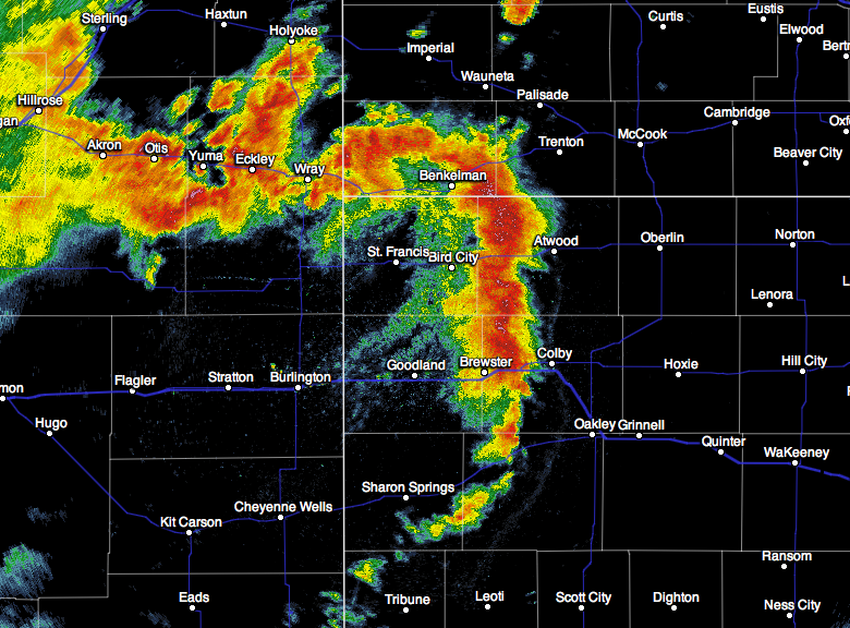
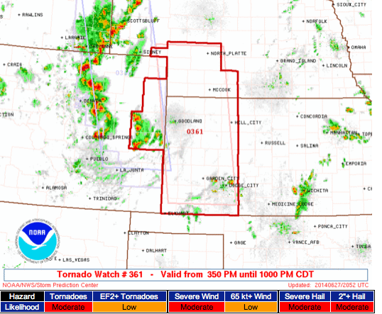
Radar recap of the derecho which knocked out power to 200,000+ homes and businesses:
Tremendous number of storm reports.
ORIGINAL POSTING:
Widespread damage has already occurred with the derecho. It should reach O'Hare and Midway airports around 6:30pm, causing massive delays. Radar, 4:53pm.
There have been a few tornadoes embedded in the line. There is a tornado warning out southwest of Madison, WI at this moment. Radar 4:51pm.
Monday, June 30, 2014
"Particularly Dangerous Situation" Severe Thunderstorm Watch for Chicago and Milwaukee
The rarest type of watch:
I disagree the likelihood of tornadoes is "low." I would call it "moderate" in this area. The tornadoes may well be wrapped in rain and difficult, if not impossible, to see. Wind gusts may exceed 85 mph in places with power outages likely.
Here are some safety suggestions for this particular situation. Please review if you are in the tornado watch.
- Go to the ATM and get some extra cash well before the storms approach.
- Fill your car's tank with gas or charge your electric car.
- Derechoes can move very quickly. Make sure your children and infirm relatives are accounted for at all times and can be easily and quickly sheltered.
- Know -- now -- your sheltering plan if a tornado warning is issued.
- Plan to park your car in the garage.
- Bring in lawn furniture, grills, and trampolines.
- Make sure you have a source of weather information when thunderstorms approach that will work if the power fails.
- Be sure your shelter has a flashlight, batteries, a bottle of water. Wear shoes and take your cell phones.
Note: I am not live-blogging the storms. AccuWeather is providing continuous coverage.
Tornado Watch: Iowa, Wisconsin, Illinois
…as well as two counties in far northeast Missouri. A new tornado watch has been issued ahead of the dangerous line of thunderstorms now moving through central Iowa:
This watch is scheduled to expire at 7pm CDT. It does not include Chicago at this time. I also disagree there is a "low" chance of EF-2+ intensity tornadoes. I would characterize the threat of any tornado as "high" and of EF 2-3 intensity tornadoes as "moderate." In this type of situation, relatively strong leading-edge tornadoes can occur. In addition to tornadoes, SPC is forecasting gusts to 85 mph!
Here are some safety suggestions for this particular situation. Please review if you are in the tornado watch.
- Go to the ATM and get some extra cash well before the storms approach.
- Fill your car's tank with gas or charge your electric car.
- Derechoes can move very quickly. Make sure your children and infirm relatives are accounted for at all times and can be easily and quickly sheltered.
- Know -- now -- your sheltering plan if a tornado warning is issued.
- Plan to park your car in the garage.
- Bring in lawn furniture, grills, and trampolines.
- Make sure you have a source of weather information when thunderstorms approach that will work if the power fails.
- Be sure your shelter has a flashlight, batteries, a bottle of water. Wear shoes and take your cell phones.
Note: I am not live-blogging the storms. AccuWeather is providing continuous coverage.
First of the "Leading Edge" Tornado Threats
This morning, I wrote about the potential for tornadoes on the leading edge of thunderstorms. We now have a tornado warning southwest of Des Moines in just such a situation.
Unlike a supercell tornado, a tornado with a derecho has a hook or "claw" protruding from the leading side (east) side of the solid or near-solid line of thunderstorms (arrow).
You still get the rotational couplet as captured below (circle).
Take all of your regular tornado precautions!
Addition 12:59pm: A tornado was confirmed near/at Stuart, Iowa, with this system.
Derecho Danger!
In addition to the significant risk of tornadoes (tornado watch continues in effect), a second major weather risk is developing for Iowa: a derecho. A derecho is a long-lived, widespread damaging wind event quite capable of causing power failures. Derechoes also cause tornadoes but usually on the leading edge of the storm rather than the trailing edge.
Here are some safety suggestions:
- Go to the ATM and get some extra cash well before the storms approach.
- Fill your car's tank with gas or charge your electric car.
- Derechoes can move very quickly. Make sure your children and infirm relatives are accounted for at all times and can be easily and quickly sheltered.
- Plan to park your car in the garage.
- Bring in lawn furniture, grills, and trampolines.
- Make sure you have a source of weather information when thunderstorms approach that will work if the power fails.
- Be sure your shelter has a flashlight, batteries, a bottle of water. Wear shoes and take your cell phones.
I am not able to live-blog these storms. Please go to AccuWeather.com for more information throughout the day.
UPDATE: 11:47am CDT…
With a derecho looking more and more likely, the Storm Prediction Center has updated its damaging wind forecast since I posted their 8am version below.
Fifteen percent is the significant threshold for thunderstorm-related wind gusts of 60 mph or higher. The hatched area is where wind gusts of 75 mph or higher are forecast to occur.
Tornado Watch Issued Already!
It is quite unusual for a tornado watch to be issued at 9:35 am, but here it is. A tornado warning is already in effect in Iowa. Note the probability of tornadoes is "high" and of violent tornadoes, "moderate."
Midwest: Another Stormy Day
Here we go again. After tornadoes and violent storms yesterday, it looks like more of the same today.
Tornado Risk:
Five percent is the significant threshold. Fifteen percent is quite high and the hatching means violent tornadoes are forecast. Please make sure sure you monitor the weather in these areas!
Tornado Risk:
Five percent is the significant threshold. Fifteen percent is quite high and the hatching means violent tornadoes are forecast. Please make sure sure you monitor the weather in these areas!
Damaging Wind Risk:
Fifteen percent is the significant threshold for winds of 60 mph or more. The hatched area is where winds of 75 mph or more are forecast.
Large Hail Risk
Again, 15% is the significant threshold for 1" or larger hail. The hatched area is where 2" or larger hail is forecast.
Bottom line: This is a potentially dangerous situation from Kansas to Michigan. If you live in these areas:
- Plan to park your car in the garage
- Bring in lawn furniture, grills, and trampolines
- Make sure you have a source of weather information when thunderstorms approach
- Be sure your shelter has a flashlight, batteries, a bottle of water. Wear shoes and take your cell phones.
Red Cross' Hurricane Sandy Expenditures: "Trade Secret"
Those who have read Warnings or this blog over an extended time know I am not, in general, a fan of the American Red Cross. They just gave me another reason. ProPublica reports….
In the meantime, when there is another disaster, I'll keep giving to The Salvation Army and Catholic Charities.
Just how badly does the American Red Cross want to keep secret how it raised and spent over $300 million after Hurricane Sandy?
The charity has hired a fancy law firm to fight a public request we filed with New York state, arguing that information about its Sandy activities is a "trade secret."
The Red Cross' "trade secret" argument has persuaded the state to redact some material, though it's not clear yet how much since the documents haven't yet been released...
That's where the law firm Gibson Dunn comes in.
An attorney from the firm's New York office appealed to the attorney general to block disclosure of some of the Sandy information, citing the state Freedom of Information Law's trade secret exemption.
The documents include "internal and proprietary methodology and procedures for fundraising, confidential information about its internal operations, and confidential financial information," wrote Gabrielle Levin of Gibson Dunn in a letter to the attorney general's office.
If those details were disclosed, "the American Red Cross would suffer competitive harm because its competitors would be able to mimic the American Red Cross's business model for an increased competitive advantage," Levin wrote.
The letter doesn't specify who the Red Cross' "competitors" are.
Please click on the link to read the entire story.In the meantime, when there is another disaster, I'll keep giving to The Salvation Army and Catholic Charities.
Green Energy: Doesn't Work
Examiner Editorial: Admit it, greens --- renewables can't power U.S. economy
Finally, finally, people are waking up to reality: Global warming is a (net) small problem and that 'green' energy cannot power the U.S. economy.
Big Green activists have taken their crusade against hydraulic fracturing to a number of state capitols for the same reason they oppose the Keystone XL pipeline. They want the fossil fuels that power the U.S. economy to remain in the ground, untapped. The fact that the ongoing natural gas boom is doing far more through market forces to reduce the use of coal than any government regulation is apparently irrelevant to them.
But the question they must answer is precisely how they propose to keep the American economy functioning until green power can actually replace fossil fuels. It is an important question, because renewable fuel cannot do the job – not even under the Obama administration's most optimistic projections.
The little discussed reality is that renewable energy cannot function without heavy subsidies in the form of producer and consumer tax credits, purchase mandates, and large loan guarantees to companies like the now-bankrupt Solyndra.
But this is only part of the problem. Not only are renewables (other than hydro-electric) already more costly than other energy sources, but there is also no serious chance they can expand sufficiently to produce the energy the economy needs now or for years to come.
The entire editorial is here.Addition:
And, sure enough, USA Today has an editorial on this topic today:
Is it fair to use climate policies to keep poor people poor?
Access to cheap and abundant power is one of the best ways to lift people out of poverty. Analyses show that there is a clear connection between growth and energy availability in Africa. Most spectacularly, China lifted 680 million people out of poverty over the past 30 years — not through expensive wind and solar, but through cheap, if polluting, coal.
It is immoral to use a speculative problem to keep people in poverty now.
Sunday, June 29, 2014
Two Tornado Warnings - Atchison to St. Joseph
9:34pm: Flash flood warning (green) with serious flooding possible. Tornado warnings in red. DeKalb should continue tornado precautions. Last update of the night! Tornado watch continues in northeast Kansas and NW MO.
9:22pm, broad rotation. Damaging winds likely. Tornado possible. One was confirmed at 9:17 near Rushville. Take cover toward I-29. Take cover in DeKalb and areas between DeKalb and Iatan.
Via Twitter, just got this photo of tornado in Atchison area.
We are getting reports of tornado touchdowns from Atchison, KS to Rushville, MO. At 9:12pm, there were two areas of rotation between Rushville and Lewis & Clark Village. We have had some minor damage reported, hopefully, that is all that is occurring.
8:48pm, rotation right on top of Atchison, JKS
8:46pm, rotating wall cloud near Atchison. Via KMBC TV.
Two areas of rotation. Take cover in these areas. Radar, 8:41pm.
Tornado Warning: Atchison, KS - DeKalb, MO
See above thread.
8:33pm, strong tornado signature near Mo. Rvr moving NE to NNE with a second signature to southwest. Continue precautions!
8:26pm Radar shows two areas of rotation, one over Atchison and the second WSW of Atchison moving ENE.
Radar at 8:24pm. Possible tornado near Atchison movie ENE. Moving toward Agency, MO.
Tornado Warning in Northwest Missouri
Red polygon is tornado warning. Yellow is severe thunderstorm warning. Radar from 8pm.
Note new storms developing north and south of Topeka.
Heads Up, Kansas
UPDATE 6pm CDT:
Radar at 5:57pm shows four areas in Kansas where thunderstorms are starting to develop.
ORIGINAL POSTING:
The atmosphere over parts of central Kansas and the Flint Hills region seems to be destabilizing rapidly. There is a weak impulse over central-western Kansas that I think could cause thunderstorms in the area outlined in yellow this evening, south of the tornado watch in Nebraska. So, I'd suggest keeping an eye on the weather if thunderstorms develop near you.
Tornado Watch: Nebraska, Iowa, Missouri
Storms are starting to increase in intensity. Keep an eye on the weather in this region. The watch expires at 11pm.
Books About World War I
Forecaster Evie's other grandfather is a World War I historian. If you would like to read books about how the world went from nearly a century of peace to the extremely turbulent world of the 20th and, so far, 21st century, here are Dennis' recommendations.
Stormy Start to Week
It looks like another stormy day in the Midwest. With probability forecasts from the Storm Prediction Center, let's break it down:
Tornado Probability
Here, 5% is the significant threshold. It includes KC, Des Moines, Quincy, Topeka and Omaha.
Damaging Thunderstorm Winds
Fifteen percent is the significant threshold for wind gusts of 60 mph or more. In the hatching, gusts of 75 mph or more are possible.
Large Hail
Again, 15% is the significant threshold for 1" or larger hail. Where you see the hatching, hail 2" or larger is expected.
And, for tomorrow:
This is the combined (tornado, hail, wind) probability map with 15% significant.
So, please keep up on the weather if you live in these areas!
Sunday Feature: Video of the Most Predictable Train Derailment in History
I'm not sure why a passenger train would move forward with a visible defect in the rail (see below), but
move he did with predictable results.
Saturday, June 28, 2014
Yes, There Are More Problems With Climate DATA
All over the blogosphere this past week, the usual climate crowd was proclaiming that May, 2014, was the warmest month (note how when a month is cold, it is "weather" and when a month is hot, it is "climate") "in history," "in the month of May," etc. Why the confusion?
Because there is yet another problem in the climate data.
While it has probably been a couple of years since I have written about it, there is a lot of fudging* that goes on in climate data. Here is a well-known fudge in the NASA data that has never been fully explained by NASA.
View the animation here. As is clear when you see the animation, the older temperatures magically get colder while the more recent temperatures get warmer.
And, this is still going on. This graph shows all of the recent 'adjustments' are to warm the atmosphere where many of the changes prior to 1980 are to cool the atmosphere. This means the upslope in recent temperatures is more dramatic.
Even here in Kansas, they continue to tinker with the temperature data. As Paul Homewood comments,
But this leaves the question of just why there is a need to continually adjust current temperatures upwards.
In the last 24 hours, both Anthony Watts and Judy Curry have weighed in on this mess that causes temperatures to appear warmer than they actually are. As Anthony has stated, I believe we will be hearing more about this in the next week.
For the record, this blog has always used the unadjusted HADCRUT3 data set unless otherwise stated. I believe that data base demonstrates trends in temperatures better than the others. I do not "cherry-pick" between data sets.
*Why does this occur? Sometimes the adjustments are legitimate such as synching measurements that are taken at different times of day or when a weather station is moved. Some of it appears to be what is caused "noble cause corruption" -- massaging the data to support what the person believes supports a worthy cause.
Because there is yet another problem in the climate data.
While it has probably been a couple of years since I have written about it, there is a lot of fudging* that goes on in climate data. Here is a well-known fudge in the NASA data that has never been fully explained by NASA.
And, this is still going on. This graph shows all of the recent 'adjustments' are to warm the atmosphere where many of the changes prior to 1980 are to cool the atmosphere. This means the upslope in recent temperatures is more dramatic.
Even here in Kansas, they continue to tinker with the temperature data. As Paul Homewood comments,
But this leaves the question of just why there is a need to continually adjust current temperatures upwards.
In the last 24 hours, both Anthony Watts and Judy Curry have weighed in on this mess that causes temperatures to appear warmer than they actually are. As Anthony has stated, I believe we will be hearing more about this in the next week.
For the record, this blog has always used the unadjusted HADCRUT3 data set unless otherwise stated. I believe that data base demonstrates trends in temperatures better than the others. I do not "cherry-pick" between data sets.
*Why does this occur? Sometimes the adjustments are legitimate such as synching measurements that are taken at different times of day or when a weather station is moved. Some of it appears to be what is caused "noble cause corruption" -- massaging the data to support what the person believes supports a worthy cause.
Glenn Reynolds Says...
![]() |
Wind turbine destroyed by high winds. |
"INSANITY CONSISTS OF DOING THE SAME THING OVER AND OVER AGAIN, EXPECTING A DIFFERENT RESULT: Obama-Style Climate and Energy Programs Have Failed Everywhere They’ve Been Tried. Why repeat this tragedy in America?
But failure is in the eye of the beholder. In terms of opportunities for graft, they’ve been a splendid success."
Tropical Trouble?
For the first time this season, there is a system in the Atlantic we need to keep an eye on.
It is moving very slowly toward the south.
Heads Up Midwest!
A nasty severe weather outbreak is forecast to occur Sunday and Sunday night: Tornadoes, very large hail and wind gusts in excess of 75 mph (the latter two in the hatched area). Keeping in mind that 15% is the significant threshold, 45% is a high number.
I'll be updating the blog on this threat tomorrow. Meantime, keep this in the back of your mind if you will be in these areas tomorrow.
"More Exciting Than Christmas!"
…was the comment from a Kansas corn farmer who was celebrating the recent rains that came "just at the right time" for his crop. Here is a map of seven day rainfall. These rains are helping end the drought that still affects the region.
The rains are delaying the 2014 winter wheat crop harvest.
Dry Downburst at Air Force Academy
As Dr. Ted Fujita discovered, there are dry as well as "wet" downbursts. This is the former striking the ground at the U.S. Air Force Academy field in Colorado earlier this week.
Last month, AccuWeather meteorology Molly McCollum and I chased down a number of dry downbursts in southwest Kansas. The photo below shows soil "exploding" when the strong winds hit the ground.
We'll have much more on downbursts on the blog next week. Stay tuned.
Friday, June 27, 2014
Occurring Now: What is a QLCS Tornado?
When we talk about the vicious twin tornadoes in northeast Nebraska last week, those are "supercell" type tornadoes. Supercell refers to the parent storm.
There have been at least three tornadoes in northwest Kansas in the last two hours but they are of a different type than what we usually discuss. These are technically called "Quasi-Linear Convective System" (QLCS) tornadoes. For simplicity, I call them "squall line tornadoes."These tornadoes are not landspouts (a third form of tornado) in spite of what some in the media have reported.
In general, this is the hierarchy of tornadoes:
- Supercell tornadoes
- Squall line tornadoes
- Landspout tornado
- Gustnado
Most squall line tornadoes are relatively weak: F0 to F1. But, once in a while, they will reach F2-3 and those can cause fatalities (April 27, 2011, in Alabama killed a dozen people that morning). They occur on the leading edge of a line of thunderstorms. Here is a video of a destructive F-3 squall line tornado in St. Louis on May 31, 2013.
Tornado Watch in the High Plains
This watch is in effect until 10pm CDT/9pm MDT. I believe there will be several tornadoes in this area before the evening is out.
Right now (3:56pm CDT), radar shows rapidly-developing thunderstorms near the KS-CO border that are moving northeast. Keep an eye on the weather in these areas!
AccuWeather Enterprise Solutions: The "Gold Standard"
So, says Tulane University:
Beginning on July 1, Tulane will switch to the AccuWeather service, which will keep administrators supplied with up-to-the-minute information.
This is testament to our incredible team and our state-of-the-art technology.
If knowledge is power, when it comes to dealing with hurricane season in New Orleans, the Office of Emergency Management is counting on a powerful new tool to keep the Tulane University community in the know.
Director of emergency management Norris Yabrough says he’s seen steady improvement in the emergency planning at Tulane since he arrived in 2013. (Photo by Ryan Rivet)
“AccuWeather is really the industry gold standard in tropical monitoring, forecasting and storm tracking,” says Norris Yarbrough, director of the Office of Emergency Management. “We’ll get an increased level of accuracy in the data they push to us, as well as the amount of data we’ll receive. It will allow us to make decisions with the most up-to-date information out there.”
This is testament to our incredible team and our state-of-the-art technology.
Thunderstorms Will Be Active Next Three Days
It is going to be another active weekend in the central third of the U.S. Graphics from the SPC.
Today and Tonight:
With 5% the significant threshold, people in the central High Plains need to keep an eye out tomorrow.
Very large hail (greater than two inches) is forecast in the hatched area. On this graphic 15% is the significant threshold for 1" hail.
Saturday and Saturday Night:
On this map, 15% is the significant threshold:
Sunday and Sunday Night:
This could be a very active area, complete with tornadoes, so caution is advised.
At 8:03am Friday, thunderstorms are already occurring from Omaha to west of Salina. It is going to be a busy weekend for meteorologists in the Midwest.
Subscribe to:
Posts (Atom)