Posts

Showing posts from May, 2017

Get Ready For Flight Delays...

Image
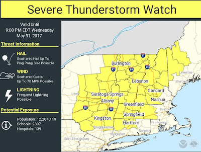
...if you are flying in the Northeast this afternoon. At the time of this posting, the following weather-related delays are imposed on flights arriving at these airports: Boston: one hour, 22 minutes Newark: one hour, 21 minutes LaGuardia: 24 minutes The NWS SPC forecasts storms to cause large hail and gusts to 70 mph in the yellow-tinted counties.  [if you are on the ground, pay attention to the weather in these areas] So, if you are scheduled to fly to Boston, Albany, Hartford, Providence, or the NYC airports, I suggest the following: If you get to the airport and find there is an earlier flight, go to the gate and volunteer to take it. Earlier is better in this situation.  Purchase a water bottle and light  food if you want it. These are the situations where your flight could leave the gate and then sit on the tarmac for an hour or two. However, don't plan on eating anything really heavy. The thunderstorms could generate turbulence that might make you un

Must See Supercell Video

There is a must-see supercell video, here . People wonder what meteorologists mean when we talk about "rotating supercells." This time-lapse video should make it clear.

Global Warming: Is There Anything It Can't Do?! Part: XXIV

Image
Or, perhaps, this would be better titled, "Global Warming, Is There Any Study Too Silly for Newspapers to Headline?!" From coast.... to coast... major newspapers published this silly study. I call it silly because it is based on yet another computer model projection of global warming into the future. What these so-called studies don't tell their readers is that many more people from cold than from heat worldwide. Warmer weather will, if it occurs, cause a net decrease in temperature-related mortality.

Reminder: Act Now!

Image
If you want a copy for Dad or Grad, now is the time to act! Warnings  is officially out-of-print. Amazon is down to four copies, which they are selling for $18.50 (today). It is possible that the big book wholesalers like Ingrams may have a few additional copies. But, if you want a hardcover copy of the book for a graduation or Father's Day gift, please act now. I still have a limited number of the book which I am happy to sign and sell for $25.00 which includes taxes and priority mail shipping. Email me at  mikesmithenterprises  at mac dot com  for details.

It Was a Huge Severe Weather Day -- But, Not For Tornadoes

Image
Yesterday, I warned of damaging winds, large hail and tornadoes with special emphasis on staying off lakes with thunderstorms anywhere in the region. The first two worked out fine. The tornado forecast did not. So far, there has only been one tornado report from yesterday (the red dot in Missouri). Here is the rest of the legend: The giant hail forecast also worked out with 45 reports. I do not have a good explanation as to why the tornado forecast was so off base. I do know there was a research program going on in Oklahoma yesterday. I'm hoping they will be able to figure it out. UPDATED: 3 tornadoes.

Sunday Fun: You Don't Want to Argue With Science, Do You?!

Image
Here is a link to the entire story .  Happy eating!!

New Tornado Watch Until 2am

Image
The threat for violent weather in the Ozarks, Plains and Midwest is not going to end soon, unfortunately. Note: the potential for violent tornadoes is "moderate." Keep advised the weather overnight.

Oklahoma & Arkansas: Tornado Watch Until Midnight

Image
I'm worried about this one. The tornado parameters in the northern third of this watch are very impressive. I would not be surprised to see some large, violent tornadoes in the watch. In addition, 3"+ hail is possible, if thunderstorms get organized. It is critical that people in this watch keep an eye on the weather!

Tornado Watch: Missouri & Far Eastern Kansas

Image
Please note: There is a "moderate" risk of strong (EF-2+) tornadoes. There is a high risk of winds of more than 60 mph and a moderate risk of winds above 75 mph. High risk of hail larger than 2" in diameter. So far, these storms are producing a lot of lightning. So, please take these storms seriously and move to a place of shelter if a warning is issued. I recommend staying off the water if storms are anywhere close. 

Major Severe Thunderstorm and Tornado Period Ahead

Image
Unfortunately, it looks like it is going to be a severe weather day as forecast. This forecast is valid from now until 7am Sunday. We'll break things down as follows. Tornado Risk On this forecast map, 5% (brown) is the significant threshold for tornadoes. The hatched area is where violent tornadoes are forecast to occur. Damaging Thunderstorm Winds Wow. In the hatched area, thunderstorm-generated wind gusts may exceed 75 mph. Needless to say, bring in anything that may be blown about (i.e., lawn furniture, etc.). The significant threshold on this map is 15% (yellow). In the non-hatched areas, wind gusts may exceed 60 mph. Giant Hail There is no much instability in the atmosphere that, in the hatched area, hail size might exceed 4 inches. The significant threshold on this map is 15% (yellow) which forecasts hailstones of 1" or more. Obviously, put your car in the garage. I will not live-blog the storms but I will provide a couple of updates today. Please tak

Reminder......

I provide additional information on Twitter:  @usweatherexpert . I no longer "live blog" storms.

Tornado Watch: Illinois and Indiana

Image
This watch is in effect until 8pm CDT/9pm EDT.  Below is the radar from 2:51pm CDT. There are already severe thunderstorm warnings out for 60 mph winds. There could be some very strong winds the rest of the afternoon and early evening along with wind-driven hail. Put the car in along with any other objects that might be blown about.

Major Severe Weather Day Tomorrow

Image
Keep up on the weather tomorrow, especially if you are camping, boating or engaged in some other outdoor activity.  Saturday is going to be a very busy day, unfortunately. Please figure this into your holiday plans! In the purple area, there is a high risk of damaging thunderstorm winds that will be accompanied in some areas by large hail. Power failures and trees blocking roads are a real possibility. The highest winds will occur from the Ozarks into western Kentucky. High winds will continue farther east. Note: The storms will be very fast-moving. Do not assume you are safe because the storm is 50 miles away.  In the western part of the area, from I-35/I-135 to the Ozarks is where tornadoes are also possible. The significant threshold for severe weather on this map is 15% (yellow). The hatched area is where the most violent storms are expected.

Little Change

The Memorial Day Weekend forecast below still looks good. I will have a complete update early this afternoon.

AccuWeather's Memorial Day Weekend Forecast: Caution is Advised

Image
As you plan for the weekend, here is AccuWeather's forecast: Where it says "strong storms," more detail is needed. For that we turn to the NWS SPC. Above is an important map. It is the probability of severe thunderstorms (large hail and damaging thunderstorm winds) and tornadoes between 7am Saturday and 7am Sunday. The significant probability threshold is 15% on this chart. The hatching is where very  large hail, extreme winds and violent tornadoes are possible. Therefore, I urge you to take along a portable NOAA weather radio plus the new AccuWeather app (and turn on the GPS function).

One Last Posting For the Day

Image
With all of the tornado watches issued today, I didn't get a chance to post this until this evening. Here is a summary of the tornadoes near Dodge City one year ago today . It was my chase of a lifetime (along with at least 100 other chasers)! And, if you are interested in the meteorology behind all of these storms, here is a great summary . The best thing? Thirteen tornadoes and very little damage.

Act Now. Only 5 Left at Amazon.

Image
"She got so excited, she started singing 'Ave Maria'." That is the comment about Warnings: The True Story of How Science Tamed the Weather  I received on my Facebook page yesterday. A young lady interested in weather received it as a gift and was ecstatic. However... Warnings is officially out of print. The publisher is sold out. Amazon is down to 5 copies. While it is possible there are a few more in wholesalers' warehouses, you should act quickly if you wish to get a copy for Father's Day or a graduate.  While the ebook version (with eight additional photographs we were not able to get into the print version) will be available more or less forever, if you want a hardcover copy, please order right away.

Third Tornado Watch of the Day

Image
Please keep in mind that I provide additional, real-time information on Twitter @usweatherexpert . 

Busy Tornado Day in the Southeast

Image
Second tornado watch of the day was just issued. Keep a close eye on the weather in this area.

Tornado Watch: Florida and Georgia

Image
Tornado watch was just issued for southern Georgia and northern Florida. Please keep up on the latest weather information!

Difference Between European and US Weather Modeling

Image
In weather forecasting, we need both regional and global models. It has become well known, even to the public, that many nations are ahead of the U.S. in global weather forecasting models. I try not to get into too much "inside baseball" on the blog but here is a graph (thank you, Dr. Ryan Maue) that shows the difference between the U.S. global model (red) and the European global model (blue). Higher is better. When I am in a hurry, I will often look at the European model's forecast of the U.S. weather pattern and not even bother with the U.S.'s forecast of the United States. Sad, isn't it? One of the things the Trump Administration is going to have to consider is how to get the U.S. back into contention in global weather forecasting.d One strategy is to "buy into" the European modeling consortium (ECMWF) and use their global model while the USA concentrates on fine-scale "mesoscale modeling." If we try to exceed the ECMWF, it will cost

Why Little League Games Need to Be Called Off BEFORE the Sirens Sound

Image
Sigh. Here we go again. Over the years, I have found that little league umpires (baseball, soccer, football, doesn't matter) are extremely reluctant to call a game for weather no matter how dangerous conditions are. I remember getting into a shouting match with an umpire during son Brandon's little league game as extremely dangerous and frequent cloud-to-ground lightning was approaching and had gotten within three miles. Now, we have a video of a little league game continuing as tornado sirens sounded last week . That is no surprise to me. When the threat is major ("high" risk of tornadoes) or there is another substantial severe weather threat, and it is known eleven hours in advance, the games never should have been played. League officials should have called them off in plenty of time to notify players and parents. My experience is there is a macho thing going on. Umpires and referees don't want to look like wimps by calling the games due to weather. Ye

"I'll Believe Global Warming is a Crisis When the People Telling Me It Is a Crisis Start Acting Like It Is a Crisis"

Image
The title represents Instapundit's  Glenn Reynold's sage comment from at least five years ago that highlights the extreme hypocrisy of the catastrophic global warming movement. Unfortunately, President Obama is the latest example. After giving a speech which said told us -- those of us with the relatively small carbon footprints -- that we have to cut our  carbon footprints and our dietary patterns to fight global warming. Meanwhile, President Obama, when traveling to Italy to give his speech: Took a private jet instead of flying first class commercial. Rode in an SUV. Had a thirteen vehicle (!!) motorcade. Used 22 hotel rooms Somehow, former Presidents Bush and Carter get along without 13-car motorcades. The Wall Street Journal' s HeatSt put it this way, In just his trip back and forth to Italy, for his presentation and his vacation, Barack Obama has emitted more than 16 metric tons of carbon – just  shy of what an average American emits in a  year . 

Sixth Anniversary of the Joplin Tornado

Image
Please take a moment to say a prayer for those who were lost in the Joplin tornado and for those that have done the hard work of making the city's marvelous recovery a reality. Today is the sixth anniversary of the horrific Joplin tornado. Since we have literally thousands of new readers as a result of last week's tornadoes, I would like to make you aware that my second book was about what went terribly wrong with the warning system that day. Like Warnings , it is written in the form of a novel but it is an entirely true account of what occurred. If you go to Sirens'  Amazon site, you'll see a lot of vitriolic 1-star reviews. Those are from people with or associated with the National Weather Service, which has never come to grips with its institutional role in the the tragedy. Please note: the names of the people associated with the warning system that day are withheld. My goal in writing the book was to fix the problems with the warning system, not embarrass peo

"Warnings": The Countdown Continues

Image
While wholesalers like Ingrams may still have a few copies in their warehouses -- so your local bookseller can still order it for a short while longer -- the publisher of Warnings: The True Story of How Science Tamed the Weather has run out of copies of the book. So, it will be officially "out of print" shortly. Here is an excerpt of a review posted on Facebook just twelve hours ago: To say I enjoyed this book and found it educational would be an understatement! As of a few minutes ago, Amazon said it was down to eight copies. If you want to order a copy for a graduate, or for Dad, you may want to order now while hardcover copies are still available.  Note: The ebook will remain on sale. It has eight extra photos we were not able to get into the hardcover version. Second note: I still have a couple of boxes of the book. If you want an autographed book, they are available at $25/copy, including taxes and shipping. Email me at  mike at mikesmithenterprises.com a

Sunday Fun II: From the Immortal Chuck Yeager

Image

Sunday Fun: An Entirely New Color

The first new color in 200+ years. Details here .

60th Anniversary of the Ruskin Heights Tornado

Image
Today is the 60th anniversary of the most important day of my life: The Ruskin Heights Tornado. I  some personal reflections. If I had not experienced that tornado, I wouldn't be a meteorologist. I likely wouldn't have married Kathleen. Her home was damaged in the tornado. Ours only had debris in the yard.  The entire course of my life would have been different. My mother drove my brothers and me down Bennington Street (see below) and day after and I  was hooked. At the age of five, I knew I wanted to be a meteorologist. Anything with that power had to be pretty interesting! It was also was one of the most important tornadoes in history. It was probably the tornado that caused the (then) Weather Bureau to get into the formal tornado warning business, after resisting for years.  My book, Warnings: The True Story of How Science Tamed the Weather , begins with the Ruskin Heights Tornado . The red link will take you to that chapter which you can read at no char

175 mi. Long Tornadic Circulation Across Kansas

Image
While there were a number of tornadoes in Kansas today, there was one circulation that stands out. This evening, there were strong radar indications of tornado(es) in the sparsely populated Flint Hills. There were reports of tornadoes with it from northwest of Medicine Lodge to near Bushong and an unknown number in between. Medicine Lodge tornado. Bushong tornado. It is difficult to get a good photo of a tornado at night, the long exposures needed tends to blur them. It is unknown whether the storm will produce an additional tornado. It has certainly been a busy week for weather in Kansas.

Tornado Watch: Kansas and Oklahoma

Image
A tornado watch for south central Kansas (including Wichita) and far northern Oklahoma is in effect until 10pm. There is no chance of a violent (eg, Joplin, Greensburg) tornado but any tornado can be dangerous and destructive. Please keep an eye on the weather.

Significant Risk of Tornadoes or Large Hail, South Central Kansas

Image
A tornado was just reported NW of Medicine Lodge, Kansas. The area of thunderstorms west of Wichita is slowly strengthening and there is a risk of an additional tornado or two along with large hail as the afternoon progresses into evening. Keep an eye on the weather in the area.

Tornado Watch: Texas, Oklahoma and Arkansas

Image
This watch includes the Dallas and Ft. Worth. This is in effect until 11pm.  Please keep an eye on the weather!

Tornado Watch for Much of Missouri

Image
Please prepare accordingly!

How Good or Bad Was Yesterday's Tornado Forecast?

Image
For consistency with what the general public is hearing, I tend toward using the NWS's tornado forecasts unless I have a significant disagreement like Tuesday, when I posted my own (with a post-forecast validation, like the one I am writing now). FYI: AccuWeather does not do tornado watches or warnings for the general public. That is the job of the NWS. Our warnings are for business and enterprise clients. The way this works: I make a general severe weather forecast based on tried and true techniques and then I look at the computer models. My forecast indicated a generally high risk of tornadoes in Kansas and Oklahoma. The computer models in the pre-dawn hours Thursday were terrifying: huge, long-track tornadoes hitting population centers. Still, there was some doubt. Some of the forecast models Thursday morning showed "too many" thunderstorms for many violent tornadoes. If there are too many storms, they "compete" with each other for unstable air and becom