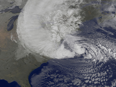
At midnight eastern time this evening, the 2012 hurricane season is officially over.
AccuWeather has a terrific summary of the season here. I'm not posting a thumbnail because it is so cool, I want you to see it in its entirety.
Friday, November 30, 2012
Is This the Long-Awaited Pattern Change? With Saturday Update.
Those of us living in the drought-striken areas of the United States and those that depend on moisture for a living or shipping have, for nearly two years, been anxiously watching for signs of rain. I may have found one.
Meteorologists know that "teleconnections" -- what is occurring in one part of the atmosphere that can affect other parts of the atmosphere -- are an important element of long-range forecasting. One of the most important teleconnections for significant moisture in the central U.S. is the development of a high pressure system in the upper atmosphere in the Pacific around 130°W. Today's European model shows just that (arrow) in ten days. Once the high forms, storms are guided into the West then Central parts of the U.S.
The United States' NWS Global Forecast System (GFS) which forecasts farther into the future than the European, shows exactly that occurring.
Storm 1's forecast location on December 10.
Storm 2's forecast location on December 12.
Storm 3's forecast location on December 16.
So, how much rain (and snow) might result? Here are the forecast totals for storms 1 and 2 in the central U.S. (the quantitative precipitation forecast doesn't go far enough to capture the moisture from storm 3)
The light orange area from southeast Missouri through the northern Ohio Valley is five inches of moisture!
Keep your fingers crossed.
Update, at 5:30pm Saturday. My commenters below express skepticism and the same is true on Facebook. Let me give you a little secret from an experienced central U.S. forecaster. As I said on Facebook yesterday, the long range models, until we get about 72-84 hours from the actual start of the event, start the precipitation too far east. Over time, the models start moving the precipitation west. That happened on the latest version (18Z Saturday) of the U.S. GFS model.
Look how the heavier precipitation starts farther west (arrow) than on the identical graphic above which is from the 12Z Thursday run. This is exactly the behavior of the models I would expect based on years of central U.S. forecasting. I'm still feeling good about moisture in the central U.S. the middle third of December.
Meteorologists know that "teleconnections" -- what is occurring in one part of the atmosphere that can affect other parts of the atmosphere -- are an important element of long-range forecasting. One of the most important teleconnections for significant moisture in the central U.S. is the development of a high pressure system in the upper atmosphere in the Pacific around 130°W. Today's European model shows just that (arrow) in ten days. Once the high forms, storms are guided into the West then Central parts of the U.S.
The United States' NWS Global Forecast System (GFS) which forecasts farther into the future than the European, shows exactly that occurring.
Storm 1's forecast location on December 10.
Storm 2's forecast location on December 12.
Storm 3's forecast location on December 16.
So, how much rain (and snow) might result? Here are the forecast totals for storms 1 and 2 in the central U.S. (the quantitative precipitation forecast doesn't go far enough to capture the moisture from storm 3)
![]() |
click to enlarge, from NWS GFS model |
Keep your fingers crossed.
Update, at 5:30pm Saturday. My commenters below express skepticism and the same is true on Facebook. Let me give you a little secret from an experienced central U.S. forecaster. As I said on Facebook yesterday, the long range models, until we get about 72-84 hours from the actual start of the event, start the precipitation too far east. Over time, the models start moving the precipitation west. That happened on the latest version (18Z Saturday) of the U.S. GFS model.
Look how the heavier precipitation starts farther west (arrow) than on the identical graphic above which is from the 12Z Thursday run. This is exactly the behavior of the models I would expect based on years of central U.S. forecasting. I'm still feeling good about moisture in the central U.S. the middle third of December.
NWS: "Further Down the Spiral"
The crisis surrounding the National Weather Service’s (NWS’s) handling of its assessment of the agency’s performance before and during Hurricane Sandy – including but not limited to the controversial decision not to issue hurricane warnings for the northeastern United States coastline – continues to deepen
Meteorologist Nate Johnson makes some pointed observations and asks some pointed questions. You can read his entire piece here.
Climate Central's Top Five Priorities
The day after the election, I congratulated President Obama and offered a number of suggestions related to weather forecasting and atmospheric science that I believe rise to the level of national issues.
Here is a list offered by the pro-global warming group, Climate Central. While I disagree with at least two, they are well thought out and so I wanted to bring them to my readers. But, the more important point is how much we agree upon.
It doesn't matter whether you are liberal or conservative: The prospect of losing satellite data and other critical meteorological infrastructure -- absolutely essential for forecasts and warnings -- is reaching the crisis level. These issues must be tackled sooner rather than later.
Should People Be Charged for Rescues If They Remain in a Mandatory Evacuation Area?
Big governments face a similar quandary, and, in the wake of Hurricane Sandy, a delicate management question is making the rounds: Is there a better way to enforce mandatory evacuations in advance of a gathering storm?
It's a sensitive topic. Communities and businesses are still recovering from the hurricane and mourning the dead. But officials running evacuations are like any CEO trying to execute a strategy. Would some form of incentive to evacuate—perhaps a punitive one—have helped authorities get even more people out safely and reduced the need to put rescuers in harm's way?
This is a fascinating question I had not considered before. The full article is at the Wall Street Journal.
Thursday, November 29, 2012
Why NOAA is Not Telling the Truth?
USA Today's new article about the Sandy Assessment mess was just brought to my attention. It is available here.
It is unfortunate the spokeswoman for NOAA choses to state things that are not true:
"Never set in stone"?
Facts: I can provide the email approving the team, the team's charter, and even the accounting codes we were given for expense reimbursement! The team was approved and we had begun work.
I don't understand NOAA's behavior throughout this unfortunate incident and why they have decided to raise even more questions by stating things that are not true.
For the Second Time: The National Weather Service Should Not Investigate Itself
On Friday, November 2, I posted the following:
This evening, I'm posting the very same headline because the National Weather Service has decided to investigate itself.
As readers of this blog know, a few days later, I was asked to co-lead the National Weather Service's Sandy Assessment (SA):
Then, to everyone's shock, the SA was terminated three days later.
Today, the NWS did what I feared: Announced a new service assessment with no one outside of government as participants.
NOAA Statement of 11/29/12:
NOAA will proceed with an assessment of National Weather Service products and services during Sandy as it often does after damaging or deadly weather events. The new assessment team will soon form and focus on reviewing the policies underlying weather watches and warnings, and storm surge-related products. The team's report will identify best practices, provide recommendations for service improvements, and include a suggested implementation plan. The proposed assessment team includes representatives from across NOAA and other government agencies, including FEMA.
As far as I can tell, no one from the original assessment has been asked to participate in this new version.
I still believe that NOAA investigating itself (with or without other federal agencies) is a bad idea, especially with no one from outside of government participating. That said,
I wish the new Sandy SA team well and look forward to reading their findings.
Meanwhile, Problems With the Increasingly Important Field of Space Weather
Variations in space weather have the potential to disrupt the electric power grid, telecommunications and Global Positioning Systems — virtually all public infrastructure. To predict such disruptions, a comprehensive space weather forecasting system could cost between $1 billion and $2 billion during the next decade, space scientists told members of the House Space, Science and Technology Committee on Wednesday.
Costs would include replacing the Advanced Composition Explorer satellite, which provides data for geomagnetic storm warnings issued by the National Oceanic and Atmospheric Administration’s Space Weather Prediction Center, which has operated 13 years beyond its two-year design life, Laura Furgione, acting director of the National Weather Service, told the committee’s panel on space and aeronautics.
Details here.
The U.S. has been overspending on global warming research and not spending nearly enough the weather forecasting and warning infrastructure, seasonal to 1-2 year climate forecasting (where we have surprisingly little skill), and space weather.
Extreme Weather and Global Warming
![]() |
From the World Headquarters of Mike Smith Enterprises, LLC |
This was taped during the brief period when the NWS Hurricane Sandy Assessment was spinning up. As you know from other postings on this blog, the assessment was terminated five days later. If you'd like to watch, just click below:
No Trend (Up or Down) in Hurricane Strength
Earlier, I posted Dr. Ryan Maue's data that shows no upward trend in hurricanes since the late 1970's (when the weather satellite era began).
Here is similar data from NOAA's Dr. Chris Landsea:
There is absolutely no trend, up or down, in hurricane strength since 1900, in spite of pro-global warming advocates' assertions otherwise.
Hat tip: Dr. Roger Pielke, Jr.
Here is similar data from NOAA's Dr. Chris Landsea:
There is absolutely no trend, up or down, in hurricane strength since 1900, in spite of pro-global warming advocates' assertions otherwise.
Hat tip: Dr. Roger Pielke, Jr.
Wednesday, November 28, 2012
"Is There a Difference Between the Hardcover and Kindle/Nook Version of 'Warnings'?"
Wall Street Journal and Capital Weather Gang Weigh In on Terminated Sandy Assessment
At issue was the non-traditional way the NWS shared forecast information in advance of the storm’s landfall. Because of the unique meteorological characteristics of Sandy -- a hurricane that was merging with a nor’easter -- prior to landfall, the National Weather Service chose not to issue standard hurricane watches and warnings. Instead, a phalanx of non-tropical “high wind warnings”, “coastal flood warnings”, and various local statements were issued by the decentralized regional NWS offices. This decision contrasted with the run up to Hurricane Irene, when the top-down National Hurricane Center (NHC) issued official hurricane warnings from North Carolina to Massachusetts.
Bryan Norcross, the Weather Channel’s hurricane expert, was sharply critical of the decision not to issue hurricane watches and warnings, asserting NHC’s adherence to “arcane and inflexible rules” compromised clear, effective communication.
“When all hell is breaking loose, sometimes you’ve got to break a few rules to do the right thing,” Norcross blogged shortly after the decision.
Of particular concern to Norcross were Mayor Bloomberg’s remarks at a news conference two days before Sandy’s landfall, about the time hurricane watches are typically issued for approaching storms. At the time, Bloomberg downplayed Sandy’s risk.
“Although we’re expecting a large surge of water, it is not expected to be a tropical storm or hurricane-type surge,” Bloomberg said. “With this storm, we’ll likely see a slow pileup of water rather than a sudden surge, which is what you would expect with a hurricane, and which we saw with Irene 14 months ago. So it will be less dangerous.”
Norcross called Bloomberg’s remarks “incomprehensibly inexplicable” leaving him to wonder if “the missing Hurricane Watch sent the Mayor off-kilter.”
NHC director Rick Knabb admitted closely following procedure may have resulted in confusing messages.
You can read the entire posting here.
On a personal note, it is kind of interesting watching all of this unfold around me.
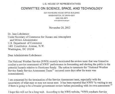
Letter from U.S. House Investigations and Oversight Subcommittee to NOAA
“I am deeply concerned by the termination of the NWS Sandy Service Assessment Team,” Chairman Broun said. “Not only does the Subcommittee want to know why the team was disbanded and when a new assessment will be initiated, we want to be assured that the future assessment will be truly independent and have access to all necessary information and staff.”
Above is an excerpt of a letter from the U.S. House to the Administrator of NOAA. This came to my attention during the last few minutes.
The full letter can be viewed here.
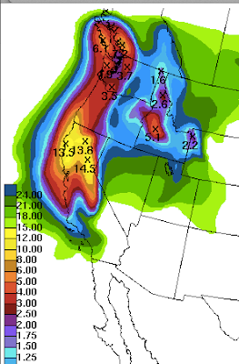
Very Serious Flood Potential on West Coast
AccuWeather has details.
These are just the five-day forecast amounts. An additional 3-5" is likely on days 6 to 10. Prepare accordingly!
There will also be air travel delays as this event unfolds. At the moment, average delays at San Francisco International are more than three hours!
Large Tornado in Italy
Mamma Mia!
Addition: According to The Washington Post the tornado, which occurred earlier today, injured at least 20 and struck a steel factory.
Update II:
Addition: According to The Washington Post the tornado, which occurred earlier today, injured at least 20 and struck a steel factory.
Update II:
(ANSA) - Taranto, November 28 - A worker is missing after the crane he was operating was blown into the sea when a tornado hit the troubled ILVA steel plant in Taranto, fire brigade sources said Wednesday.
Scuba-diver teams are reportedly on their way to Taranto to search for the worker as bad weather added to the plant's woes, with winds causing a tower and a building at the facility to collapse and a lightning bolt knocking down a chimney.
Tuesday, November 27, 2012
Flood Threat in the West
Look out Northern California and southwest Oregon. There not only is ten inches of rain possible the next five days, an additional ten inches may fall in the ten days after that.
Unfortunately, flood watches only extend to a very small portion of the threatened area at this time.
Green = flood watch.
ADDITION 10:19pm CST: From Dr. Ryan Maue via Twitter:
Unfortunately, flood watches only extend to a very small portion of the threatened area at this time.
Green = flood watch.
ADDITION 10:19pm CST: From Dr. Ryan Maue via Twitter:
California storm will be historical for rain totals.
More Than Four Weeks After Sandy 800 NYC Apartment Buildings Without Power
Hundreds of New York City landlords whose apartment buildings remain without heat or power after Sandy are being warned to get repairs lined up promptly as cold weather looms.
As predicted, there will be Sandy victims without power at the one month mark and beyond. Snow fell in NYC earlier today and the situation will only worsen as winter settles in.
There is still a great need for contributions to reputable charities. It will be many months before things begin to get back to normal.
The Weather Channel's Bryan Norcross on the Hurricane Sandy Mess
As you know, I was to co-chair the official assessment of the National Weather Service's performance during Hurricane Sandy. That assessment was terminated in an unprecedented manner by the NWS about a week after it began. A couple of items on that topic were brought to my attention today and I wanted to present them to you.
The first is from The Weather Channel's hurricane expert, Bryan Norcross:
There's no doubt in my mind that Mike Smith and the National Weather Service team would have made a detailed and accurate assessment of the questionable decisions - which I and others have roundly criticized - involving NHC advisories and the bulletins issued by local offices within the NWS's Eastern Region. But the fact is, the communications problems in Sandy reached to New York City, Trenton, Albany, and beyond.
Hopefully the rethinking of the process will mean a more extensive and far-reaching analysis so we can fully learn the lessons from Sandy... as opposed to obscuring the lessons in a cloud of finger-pointing. We'll see.
It's natural to focus on New York City because the organizations that handle emergencies there - from the Mayor's office to emergency management - are, in general, the biggest and best at what they do. But CLEARLY there was a breakdown. Sandy's storm-surge was accurately forecast to inundate the low-lying parts of the region. Somehow, as good as they are, the emergency planning and communications team in New York City did not seem to understand or plan for this scenario.
It's important for the city to learn what went wrong, but it's equally important for other emergency planners to learn as well. It will be difficult for the professional and dedicated people in New York to subject their decision-making processes to the kind of examination that should be undertaken, but it should be undertaken just the same.
Two facts highlight the problem. On Saturday, October 27th, the First Selectman of Fairfield, CT, Michael Tetreau, announced an evacuation order to be completed by 11 PM that Sunday, saying they "could see flooding that exceeds the damage from the 1938 hurricane". Yet the message from Mayor Bloomberg that same day carried nothing like that urgency.
Also, we now know that an untold number of New York City firefighters and policemen stayed in their homes near the water, only to end up leaving in the middle of the storm in a nightmare evacuation... lashing family members together to hang on through the raging water. These are people that understand that really bad crap happens in the world. You'd think that an NYC firefighter, if anybody, would have taken action to protect his family if he understood that the ocean was going to come surging through the house. That was exactly the forecast, but that, obviously, did not come through in the messaging.
For the rest, just click here. Bryan makes the same point I have made over and over: The forecasts were excellent. But, the threat messaging was poor.
The Weather Channel also has a video that you can view by clicking here. It features the National Hurricane Center's director, Rick Knabb, offering a rather odd defense of their "we're not going to issue a hurricane warning with a hurricane bearing down on the coast" policy which is, "what if, in the middle of the event, the warnings had come down (i.e., been terminated)?" That is possible in any hurricane if the storm weakens unexpectedly which was certainly not the case with Sandy.
What Knabb is really getting at is the technicality that -- according to a decision apparently made by the NWS on Friday (landfall was Monday evening) -- the storm would transition from "warm core" (aloft) to "cold core"before coming ashore -- a distinction without a difference to anyone but meteorologists. I wrote about the danger of meteorologists getting caught up in technicalities on this blog at 5:41pm Thursday, October, 25:
In the video, you saw Rick sticking to the story that Sandy made a transition to cold core one hour off the coast making "hurricane" warnings technically unnecessary even though there were hurricane-force winds and, in many areas, a hurricane storm surge that reached the levels expected with a Category 2 hurricane. The Weather Channel's Stu Ostro seems to agree with me and with independent hurricane meteorologists that, at this point, there is little scientific support for NHC's position.
The bottom line based on the evidence so far available: Hurricane warnings should have been issued for Sandy.
It is a shame that the Sandy Assessment team was not allowed to do its work. We had an excellent team that would have answered these questions, and many more, in a fair and authoritative manner. Now, with each passing day, the scientific trail gets colder and accurate answers more difficult to obtain. Memories fade. Records are lost. People move away. High water marks are destroyed as recovery proceeds. It will be much more difficult, if the NWS or a multi-agency review actually occurs, for them to establish what went right and what went wrong.
The first is from The Weather Channel's hurricane expert, Bryan Norcross:
There's no doubt in my mind that Mike Smith and the National Weather Service team would have made a detailed and accurate assessment of the questionable decisions - which I and others have roundly criticized - involving NHC advisories and the bulletins issued by local offices within the NWS's Eastern Region. But the fact is, the communications problems in Sandy reached to New York City, Trenton, Albany, and beyond.
Hopefully the rethinking of the process will mean a more extensive and far-reaching analysis so we can fully learn the lessons from Sandy... as opposed to obscuring the lessons in a cloud of finger-pointing. We'll see.
It's natural to focus on New York City because the organizations that handle emergencies there - from the Mayor's office to emergency management - are, in general, the biggest and best at what they do. But CLEARLY there was a breakdown. Sandy's storm-surge was accurately forecast to inundate the low-lying parts of the region. Somehow, as good as they are, the emergency planning and communications team in New York City did not seem to understand or plan for this scenario.
It's important for the city to learn what went wrong, but it's equally important for other emergency planners to learn as well. It will be difficult for the professional and dedicated people in New York to subject their decision-making processes to the kind of examination that should be undertaken, but it should be undertaken just the same.
Two facts highlight the problem. On Saturday, October 27th, the First Selectman of Fairfield, CT, Michael Tetreau, announced an evacuation order to be completed by 11 PM that Sunday, saying they "could see flooding that exceeds the damage from the 1938 hurricane". Yet the message from Mayor Bloomberg that same day carried nothing like that urgency.
Also, we now know that an untold number of New York City firefighters and policemen stayed in their homes near the water, only to end up leaving in the middle of the storm in a nightmare evacuation... lashing family members together to hang on through the raging water. These are people that understand that really bad crap happens in the world. You'd think that an NYC firefighter, if anybody, would have taken action to protect his family if he understood that the ocean was going to come surging through the house. That was exactly the forecast, but that, obviously, did not come through in the messaging.
For the rest, just click here. Bryan makes the same point I have made over and over: The forecasts were excellent. But, the threat messaging was poor.
The Weather Channel also has a video that you can view by clicking here. It features the National Hurricane Center's director, Rick Knabb, offering a rather odd defense of their "we're not going to issue a hurricane warning with a hurricane bearing down on the coast" policy which is, "what if, in the middle of the event, the warnings had come down (i.e., been terminated)?" That is possible in any hurricane if the storm weakens unexpectedly which was certainly not the case with Sandy.
What Knabb is really getting at is the technicality that -- according to a decision apparently made by the NWS on Friday (landfall was Monday evening) -- the storm would transition from "warm core" (aloft) to "cold core"before coming ashore -- a distinction without a difference to anyone but meteorologists. I wrote about the danger of meteorologists getting caught up in technicalities on this blog at 5:41pm Thursday, October, 25:
In the video, you saw Rick sticking to the story that Sandy made a transition to cold core one hour off the coast making "hurricane" warnings technically unnecessary even though there were hurricane-force winds and, in many areas, a hurricane storm surge that reached the levels expected with a Category 2 hurricane. The Weather Channel's Stu Ostro seems to agree with me and with independent hurricane meteorologists that, at this point, there is little scientific support for NHC's position.
![]() |
National Hurricane Center map showing Sandy to be a hurricane (red line) until it crossed the coast. |
It is a shame that the Sandy Assessment team was not allowed to do its work. We had an excellent team that would have answered these questions, and many more, in a fair and authoritative manner. Now, with each passing day, the scientific trail gets colder and accurate answers more difficult to obtain. Memories fade. Records are lost. People move away. High water marks are destroyed as recovery proceeds. It will be much more difficult, if the NWS or a multi-agency review actually occurs, for them to establish what went right and what went wrong.
Northeast Storm in Progress
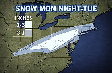
AccuWeather regional radar at 11am EDT shows the small winter storm we've been talking about the last couple of days more or less on target. The Philadelphia airport has 45 minute average delays and Newark more than an hour. Other airports in the region have, at most, minor delays.
Monday, November 26, 2012
The Drought Worsens
Snow and Thunderstorms
South of the Ohio River it is rain and lightning, to the north it is light snow. You can see forecast accumulations here.
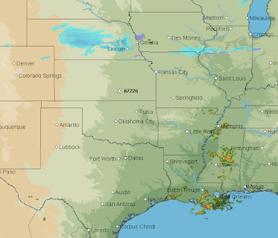
And, over Texas and Louisiana, thunderstorms are developing (6:45pm CST).
Cyber Monday Book Links
For your convenience:
Warnings hardcover click here.
Warnings Kindle, click here.
Warnings Nook, click here.
Sirens softcover, click here.
Sirens Kindle, click here.
Sirens Nook, click here.
Warnings hardcover click here.
Warnings Kindle, click here.
Warnings Nook, click here.
'Warnings' is higly educational, but it reads nothing like a textbook. The writing is engaging and entertaining from cover to cover. Even if you're not yet convinced to buy it for yourself, if you know anyone with an interest in the weather, get it for them as a gift. If you're lucky, they'll let you read it when they're done.
Sirens softcover, click here.
Sirens Kindle, click here.
Sirens Nook, click here.
Just like his other book, "Warnings," "Sirens" is a very well written book. Mike Smith tells the story of that awful day in Joplin, Missouri, in May of 2011 and makes you feel like you're a part of the story. While Sirens can pretty much be read on its own, it is a fantastic sequel to "Warnings."
Snow and Severe
AccuWeather regional radar shows light snow over Nebraska that will move east and enlarge later today bringing accumulating snows tonight and tomorrow.
AccuWeather has complete details on this developing storm.
Some good news is that, while there is a threat for some thunderstorms with large hail and damaging winds later today, the situation is looking less serious that it did yesterday.
AccuWeather has complete details on this developing storm.
Some good news is that, while there is a threat for some thunderstorms with large hail and damaging winds later today, the situation is looking less serious that it did yesterday.
Is the Weather Getting More Extreme?
The best evidence says "no." Anthony Watts aggregates the best evidence on the subject.
Sunday, November 25, 2012
One More Step in the Recovery
Weekday PATH service will resume in Lower Manhattan for the first time since superstorm Sandy at 5 a.m. Monday, the governors of New York and New Jersey said.
Full story from the Wall Street Journal.
The recovery from Sandy still has a long way to go. But, it is good to see this step after the underground railroads' stations were flooded.
Full story from the Wall Street Journal.
The recovery from Sandy still has a long way to go. But, it is good to see this step after the underground railroads' stations were flooded.
Heads Up: Texas, Arkansas, and Louisiana
While weather science generally does a great job forecasting tornadoes and severe thunderstorms, people have to be tuned in enough to know to pay attention.
So, in that spirit, I want to point out the possibility of some localized tornadoes and severe thunderstorms (i.e., large hail and damaging winds) in parts of Texas, Arkansas, and Louisiana tomorrow afternoon and evening.
And, via Dr. Ryan Maue, is the forecast radar for 5pm CST Monday evening. Do not focus on exact locations.
I'll post on this threat again tomorrow.
The "Castle" On Riverside for Sale by Auction
Ever want to live in or own a castle? One is now for sale along the Arkansas River in Wichita. It is currently operated as a boutique inn and Kathleen and I have stayed there. It is wonderful.
So, if you've ever wanted to own a castle, this may be your chance. Full details here.
![]() |
View from on top of the "Castle" |
Sunny Funny: Ford Commercial
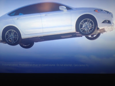
Ford is running a commercial for the 2013 Fusion that shows it flying majestically off a cliff.
As the car was flying, I thought I saw something odd flash across the screen. So, I rewound it and found this piece of obvious information:
Wonder how much the lawyer charged them for that disclaimer?
As the car was flying, I thought I saw something odd flash across the screen. So, I rewound it and found this piece of obvious information:
Wonder how much the lawyer charged them for that disclaimer?
Saturday, November 24, 2012
Sandy's Victims Continue to Be Victimized
The Long Island Power Authority continues to send out bills for the full amount as if the outages and power interruptions had never occurred!
In the Breezy Point area of NYC, homes were looted while storm victims were at Thanksgiving dinners. Details here.
These are outrages. Where are the police? The LIPA can't figure out how much power it (didn't) deliver?
This has become "Katrina on the East River" as Glenn Reynolds calls it.
In the Breezy Point area of NYC, homes were looted while storm victims were at Thanksgiving dinners. Details here.
These are outrages. Where are the police? The LIPA can't figure out how much power it (didn't) deliver?
This has become "Katrina on the East River" as Glenn Reynolds calls it.
Weather For the Trip Home
Hope you had a wonderful Thanksgiving holiday. Here are the probabilities of 1" or more of accumulating snow from 6pm Central time this evening to 6pm Central time Sunday evening.
Below are the probabilities of 4" or more of accumulation. The only area with significant probabilities is in northwest Wyoming.
How to Measure Snow
Lots of amateur meteorologists ask me the best way to measure snow. A group short, informative training videos is here.
Friday, November 23, 2012
Larry Hagman, RIP
According to the Dallas Morning News, Larry Hagman has passed away. The real life Mr. Hagman had a minor role in my book Warnings: The True Story of How Science Tamed the Weather. You can read more about it here. Our condolences to Mr. Hagman's family, friends, and fans.
Honolulu: Severe Thunderstorm Warning
Damaging winds with a little hail possible.
The storm is drifting SSE and includes Pearl Harbor, Honolulu Intl. Airport and the west part of the City of Honolulu.
Update at 7:31pm CST: The severe thunderstorm warning has expired but a flood advisory remains in effect.
Snow fell on the summit of Mauna Kea(Maui) Thursday morning and the summit road was closed this morning.
CORRECTION: I know better. Mauna Kea is on the Island of Hawaii.
The storm is drifting SSE and includes Pearl Harbor, Honolulu Intl. Airport and the west part of the City of Honolulu.
Update at 7:31pm CST: The severe thunderstorm warning has expired but a flood advisory remains in effect.
Snow fell on the summit of Mauna Kea
CORRECTION: I know better. Mauna Kea is on the Island of Hawaii.
UPDATED: Weather Books for Christmas
I was asked to recommend some weather books as Christmas gifts to give to people who have already read Warnings and Sirens. Happy to do so:
Isaac's Storm is the story of the 1900 Galveston Hurricane -- the deadliest storm in the history of the United States. It is a compelling, gripping book that has a 5-star rating at Amazon.
Eric Sloane's Weather Book is a great introduction to weather. It is very well illustrated. While I strongly recommend it as a "weather 101" book, you do need to know that the chapter about tornadoes is completely out of date.
Weather is the the first book I ever read about weather (second grade). The authors have done an admirable job updating it every few years. This would be a great book to give to a young person with an interest in weather.
ORIGINAL POSTING BELOW:
Have someone who is interested in weather on your Christmas list or someone who enjoys a great history book? I'd like to immodestly suggest you consider Warnings: The True Story of How Science Tamed the Weather. It has a 5-star rating at Amazon.
A couple of reader reviews (at the Amazon site):
Smith skillfully makes this and other controversies seem not just important, but exciting. Meteorology, in his telling, has the same bare-knuckle energy we see in politics or sports. These battles, many of which Smith himself fought in, reveal how much of our modern, weather-safe lifestyle is contingent on personalities, and could have gone another way.
While weather forecasters often appear starchy and bland, Smith makes the weather into an urgent concern, and a remarkable victory. This story turns the weather into a quest, and meteorologists into the most unlikely heroes in recent literature.
and, another (written by a book author),
I'm an admitted severe weather geek, and so I read rabidly in this genre. Quality tends to be all over the place, but so far I've only read one book I couldn't finish because it was so poorly written (and it's hard to write so badly that it overshadows the cool factor of this subject). Still, it's something I'm always aware of, and so I had put Warnings on my holiday gift list instead of just going out and buying it.
WHAT A MISTAKE! I got this book as an Easter gift and immediately began devouring it. I was instantly sorry I hadn't bought it sooner.
I'm a very busy person with little time to read, but I MADE time as I got into Warnings, and buzzed through it in four days of brief reading periods. Not only is this book about a really cool subject -- our modern-day severe storm warning system and how it almost didn't happen -- but it's written very engagingly with nary a slow spot in the entire book. As an author myself, I know how truly difficult it is to keep up such a pace without losing steam, but Mike Smith does a bang-up job all the way through.
The first chapter of Warnings can be read for no charge here. I recommend Warnings, which is a very upbeat book after the initial chapters, for anyone 12 or over.
While I am very proud of When the Sirens Were Silent, it is about a tragic tornado where the warning system did not perform well. I recommend it for weather buffs 18 years of age and over.
Here is a review from The Washington Post's Capital Weather Gang:
Both books are available on Kindle and Nook. If you are giving one of those devices as a gift, you could pre-load Warnings or Sirens.
Isaac's Storm is the story of the 1900 Galveston Hurricane -- the deadliest storm in the history of the United States. It is a compelling, gripping book that has a 5-star rating at Amazon.
Eric Sloane's Weather Book is a great introduction to weather. It is very well illustrated. While I strongly recommend it as a "weather 101" book, you do need to know that the chapter about tornadoes is completely out of date.
Weather is the the first book I ever read about weather (second grade). The authors have done an admirable job updating it every few years. This would be a great book to give to a young person with an interest in weather.
ORIGINAL POSTING BELOW:
Have someone who is interested in weather on your Christmas list or someone who enjoys a great history book? I'd like to immodestly suggest you consider Warnings: The True Story of How Science Tamed the Weather. It has a 5-star rating at Amazon.
A couple of reader reviews (at the Amazon site):
Smith skillfully makes this and other controversies seem not just important, but exciting. Meteorology, in his telling, has the same bare-knuckle energy we see in politics or sports. These battles, many of which Smith himself fought in, reveal how much of our modern, weather-safe lifestyle is contingent on personalities, and could have gone another way.
While weather forecasters often appear starchy and bland, Smith makes the weather into an urgent concern, and a remarkable victory. This story turns the weather into a quest, and meteorologists into the most unlikely heroes in recent literature.
and, another (written by a book author),
I'm an admitted severe weather geek, and so I read rabidly in this genre. Quality tends to be all over the place, but so far I've only read one book I couldn't finish because it was so poorly written (and it's hard to write so badly that it overshadows the cool factor of this subject). Still, it's something I'm always aware of, and so I had put Warnings on my holiday gift list instead of just going out and buying it.
WHAT A MISTAKE! I got this book as an Easter gift and immediately began devouring it. I was instantly sorry I hadn't bought it sooner.
I'm a very busy person with little time to read, but I MADE time as I got into Warnings, and buzzed through it in four days of brief reading periods. Not only is this book about a really cool subject -- our modern-day severe storm warning system and how it almost didn't happen -- but it's written very engagingly with nary a slow spot in the entire book. As an author myself, I know how truly difficult it is to keep up such a pace without losing steam, but Mike Smith does a bang-up job all the way through.
The first chapter of Warnings can be read for no charge here. I recommend Warnings, which is a very upbeat book after the initial chapters, for anyone 12 or over.
While I am very proud of When the Sirens Were Silent, it is about a tragic tornado where the warning system did not perform well. I recommend it for weather buffs 18 years of age and over.
Here is a review from The Washington Post's Capital Weather Gang:
The book, a quick read, is a stirring call to action to improve tornado warning communication in this country.
Smith provides a gripping countdown of the events leading up to the tornado, critiquing the series of decisions and actions from forecasters and emergency management and describing their consequences. His commentary is insightful and written plainly enough for the layperson to understand.
An important feature of the book is three lift-out pages in the back with the latest versions of the tornado safety rules for home, school, and your workplace. They will be valuable when tornado season rolls around again. Both books are available on Kindle and Nook. If you are giving one of those devices as a gift, you could pre-load Warnings or Sirens.
Did You Know the TSA's Budget is Eight Times the Size of the National Weather Service's?
With Hurricane Sandy and subsequent events, I haven't written about the TSA lately.
Even given what seems to have been poor execution of the threat messaging, the National Weather Service's forecasts were exceptionally good on a difficult to forecast storm. Yet, the NWS does not have the dollars it needs to insure that the meteorological infrastructure remains intact. If there is a federal agency that pays for itself, it is the NWS.
Then, there is the TSA.
So we are clear, there is a genuine threat to airline safety from both terrorists and random nuts. Yes, we need airline security. But nude machines? No. Stripping 17-year old girls nude in public? No.
So no one can claim the TSA isn't up on things, you'll be happy to know the TSA has new holiday 2012 regulations for snow globes:
The Transportation Security Administration earlier this month released updated guidelinesfor the millions of travelers expected to fly this holiday season. Included among the guidelines: Snow globes "that appear to contain less than 3.4 ounces" of liquid are now permitted in carry-on luggage.
The TSA's budget is $8 billion per year. The NWS budget is slightly less than $1 billion per year. Which agency do you think gives us the better value?
I've made a career of mitigating risks to people and properly. We are spending too much on the TSA and too little on the NWS.
If it were up to me, we would abolish the entire Department of Homeland Security. That stated, we need to keep the TSA's improvements (searching checked bags), make basic improvements (start guarding the planes themselves) and stop the "security theatre" in the terminals. In other words, dial it back to pre-September 11 levels. Greatly increase the professionalism of TSA staff. Can the nude machines, quit the grope-searches, allow people to keep their shoes on.
Thursday, November 22, 2012
Return Home Weather
Happy Thanksgiving
From Mindy and me, we hope you and yours have a wonderful Thanksgiving. We in America have a great deal to be thankful for.
Wednesday, November 21, 2012
Filthy Ice = Ice That Melts More Readily
Many of the photos you see on the blog are taken with my Nikon camera and they send me stuff. This morning, I received this email above which connects the recent ice melts at the north pole to "climate change."
Well, kind of.
Look closely at the photo, including the shady area at upper left. The ice is filthy. Why is that matter? Virgin ice bounces most of the energy back. Soot absorbs the sun's energy and accelerates the melting. Here is an example below.
To duplicate this effect, in December 2009, I spread two rows of fireplace soot on the snow in my backward. We started the morning with seven inches of snow on the ground. Only two inches melted in the pure snow. Four and a half inches melted in the dirty areas.
Where does the soot come from? Some papers suggest it is from China which can be seen in this photo.
Yes, there is a correlation between burning carbon fuels and soot. But, they are two different issues.
Subscribe to:
Posts (Atom)