Tuesday, March 30, 2021

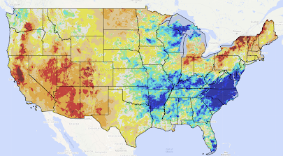
Palmer Drought Index as of March 26, 2021

Here is the latest Palmer Drought Index as of Friday. With the recent heavy rains in Tennessee over the weekend, the flood risk is very high from the Ozarks to the Middle Atlantic region if additional heavy rain should fall. 

Rip Current Danger!!

This is the best photograph of rip currents I have ever seen. I can explain in the photo below.

Rip currents slide sideways along the beach. The red circle points to a person in danger. As the current swirls down the beach (blue arrow) the person goes from being in six inches of water to suddenly being in 3-4 feet of water that comes on him or her from an unexpected direction. Sometimes the current can be strong and disorienting. All of the sudden, the person is in a situation they cannot handle. 

Most rips are more subtle but this photo -- and some bring water in from two directions -- but, this should give you the idea.

When there are rip current warnings out, be very, very careful you observe the pattern of the waves and flow before entering the water. Then, make sure you stay in shallow water. 

A Way Forward For the National Weather Service

[bumped to the top from February 16, 2020]
The National Weather Service -- again -- is having severe data problems today. The issues described in this piece have only gotten worse in the past year. The proposed solutions are still the best way forward. 
While I have great admiration for the National Weather Service, the agency is dealing with serious issues with few signs of resolution. Dr. Cliff Mass published an incisive column about one of its issues, specifically, how it is falling farther and farther behind in atmospheric modeling.

But, while weather modeling is vital, it is hardly the only serious issue with which the NWS is struggling.
  • It's weather radars were designed in the 1980's and installed in the early to middle 1990's. While they have been upgraded several times, they will not last forever. There is no real plan for their replacement. The proposals to use phased-array radar will, when it comes to tornado detection, be a step backward due to its poor resolution. 
  • It has been evident for more than twenty years that gap-filler radars are needed, at least 20 in number. The NWS has done little or nothing to acquire and install them. 
  • The promised storm warning accuracy increases from various technologies (to cite one example, here) do not appear to have panned out. In fact, tornado warning accuracy has regressed and a new version has significant issues
  • The NWS has been dragging its feat on acquiring new types of data that are essential if we are to improve storm forecasting. 
  • Instead of fixing these issues and focusing on its core mission of storm warnings and forecasts, the NWS is 'reorganizing' itself to focus on decision support services, which -- in some cases -- is corporate welfare. 
I could go on but you get the idea. I have given a great deal of thought to the future of the National Weather Service.

It is time to face facts: The National Oceanic and Atmospheric Administration, the parent agency of the National Weather Service, is failing in its management of public-sector weather in our nation. The NWS lacks a genuine vision for becoming the world's best public meteorological agency.

There seems to be no appetite in Washington to get to the root of the problem. The "ocean" side of NOAA and its constituency has far more clout than the atmosphere/weather side, even in this era of global warming concern. The first administrator of NOAA (1970-74) is the only administrator with a meteorological background in the half-century of the agency's history. The recent nominee of the Trump Administration failed because he had a weather background rather than one in fisheries or ocean enterprise.

Congress, in a rare bi-partisan manner, is more than willing to help but is not getting the guidance it needs from the agency and I doubt it will ever get that guidance because of the NWS being NOAA's figurative stepchild.

The current situation will never lead to the National Weather Service being first-in-class. So, I offer this unsolicited advice to both the Trump Administration and Congress.

The U.S. needs to do two things:

1. Split off the NWS from NOAA into an independent agency. It is time to concede NOAA, which was a good idea, needs a divorce.

2. As a Reagan conservative, I hate proposing more government. But, we desperately need a National Disaster Review Board (NDRB). Details of this proposal are here and here. The NLRB would also be tasked with verifying NWS forecasts and, especially, storm warnings. The people issuing the warnings should not be the people doing quality control evaluations.

There is a much better chance of the independent NWS striving to be best in class with the necessary tools (better models, gap-filler radars, etc.) and other essentials as an independent agency. If it does not, the NDRB will be holding its heat to the fire as the NTSB does with aviation and transportation.

Monday, March 29, 2021

A New Tornado Risk Forecasting Paradigm

Over the past two weeks there has been a lot of controversy within weather science pertaining to the risk categories used by the National Weather Service's Storm Prediction Center. It has even made CNN. 

The problem centers around the words used to describe tornado risk and the colors used to portray these risks. The existing system was designed to be used by meteorologists, only. Now that these forecasts are widely used by the public, it is past time to revamp the descriptions of the standards. 

I started using a new wording system on this blog and on Twitter in 2020 and have continued it in 2021. I propose it to my colleagues as a new industry standard. 

  • Significant Risk of a tornado is a 5% chance of a tornado of any intensity. In the above sample, it would be the yellow area. 
  • Enhanced Risk is a 10% chance. In the above, it would be orange. 
  • High Risk is a 15% or higher chance of a tornado and at least one of the tornadoes is expected to be rated F-2 or higher. The vast majority of tornado deaths are associated with tornadoes of F-2 or stronger intensity. 
  • Extreme Risk (rarely used) is a 30% chance of a tornado and at least one of the tornadoes is expected to be rated F-3 or higher. In addition to being dangerous to life and limb, mass destruction is possible. 

* The percentages refer to the chance of a tornado within 25 mi. of any given point covered by the forecast. It is the industry standard. 

In the event of a rapid-onset tornado threat requiring one of these forecasts after sunset local time, the meteorologist has the option to increase the threat one category if she/he believes it appropriate given the risk of deaths from overnight tornadoes is 2.5 times the risk from tornadoes that occur in daylight. 

That's it. We'll talk about colors in the near future. 

Sunday, March 28, 2021

The Tennessee Tornadoes + Flooding = Lessons for All of Us

Following up this week of destructive weather, there are a couple of things I would like to share with our readers....

Lesson #1

From Channel 5 in Nashville,

There was so much weather to report, you might miss the item I have highlighted -- that two NOAA Weather Radio (NWR) stations were knocked off the air during all of the tornadoes and flash floods. That is why it is essential to have at least three sources of critical weather information. NWR is a great source of information, but it is vulnerable if the power fails or if the data feed from the NWS office to the transmitter is knocked out. 

Lesson #2

There are comments in the media and social media to the effect that some were surprised by the extent of the flooding. But, it was very well forecasted!

On Friday,

On Saturday,
This was posted at 1:19pm yesterday and, when you add the amounts forecasted at that time (above) to what had already fallen, the forecast was of excellent quality. The image below is the total rainfall.

The Weather Channel via Twitter
The media is now reporting five deaths. Several of those were from people who, evidently, were safe and drove into a flooded area.

The lesson is to take flash flood forecasts and warnings just as seriously as you take warnings of tornadoes. 

Weather science has cut the death rate from tornadoes by 95%. The statistics indicate we have not had nearly that level of success with flash floods. What is not clear to me is "why"? I've tried to reason it out but have not had much success. If you have any thoughts, please feel free to share them with me via Twitter @usweatherexpert or contact me directly. Thank you. 

Sunday Fun: "Liftoff" by Eric Berger

I was so excited to read Liftoff, which is the story of the creation of SpaceX, that I saved it for my vacation so I could give it my full attention. I wasn't disappointed. It is a story worthy of the company. 

My only nit is that I wish author Eric Berger had covered the "Starman" being launched in a Tesla on top of a Falcon Heavy rocket into a orbit around the sun. Given that Starman was followed by twin rockets landing at Cape Canaveral, it seemed like it was well worth covering. You would never have seen NASA do something like that. 

I rate the book 4.8 stars. I really enjoyed it and learned a lot. 

Saturday, March 27, 2021

Newnan, Georgia, This Morning: An Incredible Tornado Warning System Success

[Bumped to top, see new info at bottom]
Early this evening, this news about the northwest Georgia tornado broke. 
This tornado struck at 12:10am. It could easily have killed more than 200 people based on the population (33,000) and time of day; if there had been no warning. 

Thanks to the Wireless Emergency Alert (WEA) alarms, apps like AccuWeather's, and weather radios that sound an alarm during the night when programmed for your location.people were awakened in time to take shelter. But, none of these would work unless meteorologists had the science and technology to provide accurate and timely information. 

Various techniques showed a high risk of tornadoes over northwest Georgia which prompted the NWS's Storm Prediction Center to issue a "mesoscale forecast" (blue polygon). I combined that with the tornado warnings (red polygon), the location of the tornado (blue dot), and my text (below illustration that I included with my 11:30pm EDT update. I circled Newnan for ease of location. 
Bottom line: We were able to give more than 30 minutes of notification for the Newnan area where the F-4 occurred. 

As the tornado got closer, we switched primarily to radar to forecast and track the storm. I thought I would show you the types of radar (to illustrate one type of technology) meteorologists view when making tornado warning decisions. 
Above is what I was viewing at 12:06am Eastern this morning,
  • The reflectivity display (the type shown on television) showed a giant debris ball. That is a strong indication of a tornado.
  • The Doppler wind data was extraordinary. It indicated rotational winds of around 160 mph --  a very violent tornado.
  • The turbulence display shows the highly turbulent winds near the center of the tornado. 
  • Finally, a display known to meteorologists as "correlation coefficient" which displayed a huge area of lofted debris -- proof this was a major tornado tracking along the ground. 
We were able to give residents of the area minute-by-minute updates forty minutes before as this terrible storm swept into the area. Yes, there was one indirect fatality (medical emergency) but the the Newnan Tornado tremendous success in terms of lives saved. 

Addition: 3pm Saturday

The National Weather Service in Birmingham sent out an interesting comparison between Thursday's tornado before it struck Centreville and a tornado which struck Centreville in 1973 when a NWS WSR-57 radar was located in that city. 

2011
The legend is the same as above except the lower left panel is storm relative wind velocity rather than turbulence (I prefer to display the latter, it is a matter of choice for a meteorologist). As with the Newnan Tornado, the storm is very easy to distinguish but I want you to focus on the "hook echo" in the upper left panel. That was all meteorologists had to go on before the Doppler radar network was installed in the 1990's.

1973
As occurred Thursday, the towns of Brent and Centreville were devastated by a violent tornado in 1973. The radar was destroyed by that tornado. 

All we had to go on was the shape/intensity of the parent thunderstorm and its pendant hook echo. There wasn't even a map -- all we had were the concentric range rings. When tornadoes threatened, speed  was vital. So, one meteorologist would be reading the radar in a dark room while a second would mark down the range (distance from the radar) and azimuth (direction from the radar) of hooks and other vital features. 
       "Hook echo, 238°/11 miles" the radar meteorologist would shout. 
       "Tornado headed into Brent and Centreville," the warning
        meteorologist would reply and would then turn to the teleprinter. 
The warning meteorologist would "cut" a paper tape (something like an old stock ticker) with the warning info which would then be put into a paper tape reader. When the circuit was clear (two weather stations could not transmit at once), the warning meteorologist would begin to feed the tape through the reader and the warning would go out. The entire process -- and, why lives were lost due to delays -- is described here

American society is much safer as a result of these improvements in science and technology. 

Hazardous Afternoon and Evening in the Mid-South

We have a flash flood forecast and an updated tornado forecast. 

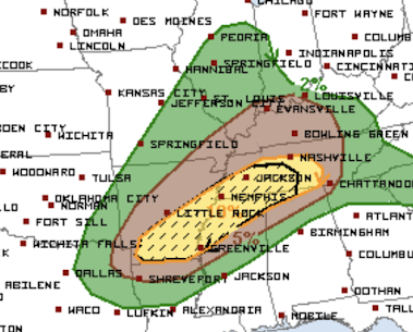
Tornado Risk

The tornado risk has been compressed into the yellow and brown areas. 

  • Yellow area is where there is an enhanced risk of tornadoes. Where the yellow is hatched is where strong tornadoes are possible.
  • Brown area is where there is a significant risk of tornadoes. 
Flood Risk

There is a serious risk of flooding through tomorrow morning in the red and orange areas. Remember: Turn around, don't drown when encountering flooded areas.

Given the tornado and flood risks, it might be a good day to stay close to home and monitor the weather. 

Tornadoes Likely Late Today and Tonight in the Mid-South

There is an enhanced risk of tornadoes today in the yellow area. Where you see hatching, some of the tornadoes could be strong. 

There is a significant risk of tornadoes in the brown area. 

On Thursday, the tornadoes began in the late morning. I don't think that will be the case today. It is more likely to be in the mid-afternoon. 

Please keep up on the weather in these areas today and tonight. 

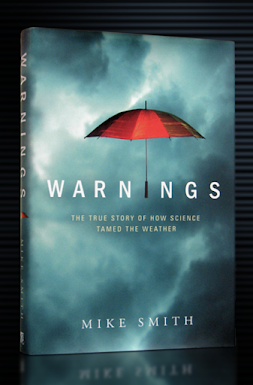
A Perfect Book For Spring

The next seven months are "storm season:" now for tornadoes and, starting May 15, for hurricanes. 

Warnings: The True Story of How Science Tamed the Weather is very much a people story -- of courageous meteorologists who bet their careers to discover and implement the science needed to save thousands of lives every year
From B&N
Goodreads.com is full of tough reviewers; here is a review from Goodreads...

I picked this book up when I was working on a journal piece dealing with storm shelter access in tornado-vulnerable regions of the country. While I used it for my research, I never sat down and just read it from cover to cover with no need. May 3, a date personal to me and my history with weather, came around, and I picked the book up to read in its entirety and in the order presented. All in all, I enjoyed the ride. While there are some moments in the middle where the science gets a little dry, but the emotions and storytelling connected to the major weather events selected by the author more than make up for those dips. 

Keeping in mind his audience, while this book could have been much longer, and more issues discussed could have been told with greater detail, Smith strikes a good balance of providing the necessary facts while holding the reader's attention. The sprinkling of human touches throughout the science makes the book intelligent and a bit emotional (but full disclosure: I am emotional at all tornado stories!).

Smith has a huge arsenal of weather events to describe, and he chooses carefully. Some tornadoes are those that affected him personally, but some events, particularly the hurricanes, are life-changing events in the history of storm prediction. In particular, his account of the numerous failings around Hurricane Katrina, committed by everyone except the meteorologists, is well done. Obviously, he cannot get into the many layers of problems before, during, and after Katrina, but his job is not to address all of those. He simply has a few chapters to discuss the science and remind the reader that the best science in the world can't overcome horrible bureaucracy.

The book ends beautifully by demonstrating how far we've come with forecasting and the ability to save lives, the foundation of all forecasting work. Smith chooses the ferocious Greensburg tornado to show how the advances in science have saved many lives. While the 1999 Bridge Creek-Moore tornado was perhaps even more of a celebration when comparing population to death toll, Smith makes good use of the facts around Greensburg to perfectly compare it to the earlier, much deadlier, yet otherwise very similar Udall tornado.

Smith has a lot to say in this area, and he says it well. 

Whether you want a "storm season book" or just a great book for spring vacation, if you like this blog, you'll really enjoy Warnings.

You can get your copy of Warnings at Barnes & Noble, Amazon and your local bookseller. If you enjoy reading this blog, you'll love Warnings. 

Friday, March 26, 2021

Yesterday and This Morning's Tornadoes: Rotation Paths


Doppler radar can sense rotation in storms but, unless there is lofted debris, cannot directly ascertain whether that rotation has reached the ground. That stated, there was a strong correlation between yesterday's rotation and corresponding tornado tracks (I covered up some noise in NW Georgia; there is also noise just south of downtown Atlanta). 

The brighter the colors, the stronger the rotation. 

The map shows remarkably long-tracked tornadoes. Pending the completion of the damage survey, the Birmingham NWS office believes that one of the tornadoes may have been on the ground at least 100 miles. This is what we meant when we forecasted "violent, long-tracked tornadoes." Those are important because they are usually the type that cause the most deaths. 

The tracks show that Birmingham (B) was struck both north and south of downtown. The suburbs southwest of Atlanta were also struck after midnight -- an extremely dangerous situation given that nighttime tornadoes cause 2.5 times more deaths than tornadoes during the day. 

I am providing this extra coverage because the national media seems to have already lessened its coverage because of the lack of deaths; even though that is a very good thing! 

If you have a chance, please contribute to legitimate charities (not the Red Cross which is poor for tornadoes) like the Salvation Army to help the victims recover more quickly. 

A Politician Who "Gets It" About the Lack of Deaths in Violent Tornadoes

Via The Weather Channel, this is the mayor of Centreville, Alabama, which suffered a tornado of at least F-3 intensity yesterday evening. He gives the praise where it belongs. 

Yesterday's Tornado Outbreak and What It Means to Us

Yesterday was an extraordinary success story for American weather science: numerous, violent, long-track tornadoes in densely populated areas yet a minuscule number of fatalities. 

While each of those deaths is a tragedy for their families and friends, without weather science it is likely there would be a hundred funerals being planned rather than seven. That is especially true since several of the violent tornadoes occurred in darkness. The forecasts and warnings made all of the difference. 

I was awakened by the sirens and sheltered in my hallway. I was sheltered when the tornado hit.

-- Newnan, Georgia, resident

Unfortunately, the mainstream media still doesn't get it. It wasn't "luck" that triggered those phones after midnight -- it was the finely-tuned tornado warning system. 

There are several aspects of yesterday's storms I wish to discuss with you. 

Safety Recommendations Reviewed

The Weather Channel aired the above photo and it illustrates one of our safety recommendations: Take shelter in the basement or lowest floor. Generally speaking, the lower -- the better. 

The next recommendation validated by yesterday's storms was: while in your basement, take shelter under a stairwell or substantial furniture like a pool table.
You can see how debris trapped the two residents for a while. Neighbors had to bring ladders for them to escape. But, this situation shows how important it is to have something to protect you from collapsing debris. 

Global Warming Nonsense

The public relations people employed by Big Climate have already begun to try to use yesterday's tragic tornadoes to sell you on catastrophic global warming. 
This is incorrect for three reasons:

Meteorologists' Homes Being Hit

On Wednesday, ABC TV meteorologist Ginger Zee posed with her mentor, Birmingham's legendary James Spann, in his trademark "respect the polygon" pose. The were trying to build awareness that major tornadoes were going to occur the following day (yesterday).

What no one could know was that James' home would be struck, with his wife at home, during yesterday's storms. I was watching at the time and James continued his life-saving work even though he had become a victim of the storm (his was wife was in shelter and okay). 

It wasn't just James: NWS meteorologist Alex Sizemore and his emergency manager wife Melissa Jo, had their new, under-construction, home damaged. 

This is what I mean by courageous meteorologists. Another example: May 3, 1999, three WeatherData, Inc meteorologists had their homes heavily damaged by a tornado in south Wichita but continued to work until the threat had ended. 

I believe Ginger is working on a story about James' experience for this evening's ABC World News Tonight. Monday evening's Nightline.

All of weather science should be extremely proud of our work yesterday: Dozens and dozens of lives were saved. 

And, if you wish to thank James, buy a copy of his excellent book

This Is Why We Urge People NOT to Stand Under Trees During a Thunderstorm

This video speaks to the validity of that lightning safety recommendation.  

Staggering Losses From the February Cold Wave

 $155 billion dollars. This is higher than Hurricanes Sandy and Katrina, combined. 

The story from AccuWeather.

Thursday, March 25, 2021

Tornado Forecast Update - 2:45pm

Considerable serious damage has already occurred in northern Alabama. 

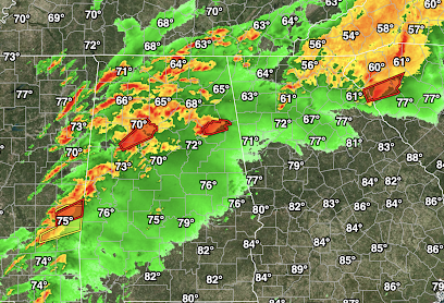
Here are the tornado warnings (red) as of 2:45pm. 

Note the thunderstorms near the Alabama- Mississippi border? Those storms should strengthen to severe or tornadic during the next hour or two and should cause the next round of tornadoes. 

The extreme risk for tornadoes today (see below) remains valid!

"Particularly Dangerous Situation" Tornado Watch Until 8pm

This is a rare particularly dangerous situation tornado watch. 

Please monitor the weather throughout these regions until at least 8pm. 

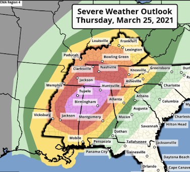
Extreme Risk of Tornadoes This Afternoon and Evening

NWS SPC Forecast Tornado Risk Forecast 
Updated 11:40pm
The "extreme risk" has been expanded
Here is the breakdown using my scale. 
  • There is an extreme risk of tornadoes in the purple area as shown on the NWS's forecast. 
  • There is a high risk of tornadoes in the red region. Violent tornadoes may occur here, as well.
  • There is an enhanced risk of tornadoes in the orange area. Strong tornadoes may occur in this region. 
  • Finally, there is a significant risk of tornadoes in the yellow-colored region. 
Given this serious tornado situation, I urge you to read and heed the information below. If you live in a mobile home and live in the extreme risk area, you may wish to suggest spending the danger period with a friend who has a trustworthy tornado shelter. 

A tornado watch means you should monitor the weather in your area and be prepared to take shelter at the first sign of a thunderstorm. 

Please particular attention to a tornado watch that contains the sentence, "This is a particularly dangerous situation." One or more of those rare watches may be issued Thursday or Thursday evening. 

When a tornado watch is issued:

  • Call family and friends to make sure they are aware of the threat and insure they are going to monitor the weather at the first sign of thunderstorms. This means the sound of thunder or darkening skies. 
  • Make sure you have a flashlight in your shelter area along with a couple of bottles of water, a radio/TV/weather radio, diapers, and a snack of the kids (something like trail mix). If you have bicycle, football or other head protection in the house, put them in the shelter area. 
  • Gather up the family of those who may need help getting to shelter. You don't want to be darting through traffic to pick up children while the sirens are sounding. Way too dangerous. 
Make sure you have at least two independent ways of getting the warning, day or night (nighttime tornadoes are more dangerous than tornadoes during the day). Activate the WEA warnings on your phone so they will awaken you during the night. 


Things you should do if a tornado warning is issued:
  • Insure your safety first! Get you and your family into shelter. Only then call friends and relatives to make sure they have gotten the warning. 
  • Stay in the shelter until you are given an all clear or until five minutes after the radar shows nothing over your location. 
  • Do not go outdoors to try to look for the tornado. Tornadoes are often invisible. Both of the locations below were struck by the Joplin Tornado but it could not be seen during its approach. 

Do you see the tornado in these pictures? The only thing you are doing by doing outside to look is putting your life in danger. 

Your local television meteorologist, especially if they have the seals of approval from the National Weather Association or the American Meteorological Society are excellent sources of information that will keep you informed during tornado warning periods. 

News From the Real World...

 ...demonstrates that carbon dioxide is not needed for the climate to change.

Wednesday, March 24, 2021

Overnight Tornado Watch in Texas

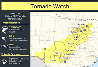
In addition to tornadoes, wind gusts to 80 mph and hail the size of tennis balls are forecasted to occur. 

Please make sure you have a weather radio set to go off for a tornado warning in your area plus an smartphone app like AccuWeather's that will trigger if a warning is issued for your location. 

I will have an update on tomorrow's weather situation in an hour or so. 

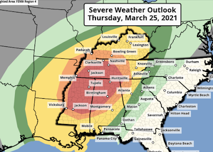
High Risk of Tornadoes in the South Thursday and Thursday Evening

Here we go again:

  • The red area has a high risk of tornadoes. Some of which could be violent. 
  • The orange area has an enhanced risk of tornadoes, some of which could be violent.
  • The yellow areas have a significant risk of tornadoes. 

The highest risk period is from noon until midnight. I don't think this tornado outbreak will continue into the overnight hours. 

I'm more concerned about the risk of violent tornadoes tomorrow than I was with the weather situation like week. It is quite possible we will be talking tomorrow about a rare "extreme" risk of tornadoes. Unlike last week, tomorrow's risk extends well north into Tennessee. 

No is the time to prepare. Please do so. 

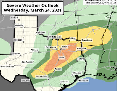
Significant Tornado Risk in East Texas

The orange area has a significant risk of tornadoes later today and this evening. Please monitor the weather in these areas.

There is a major risk of tornadoes in the South tomorrow. I'll have an update on that by around 1pm. 

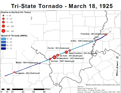
Forensic Meteorology Examination of The Great Tri-State Tornado

On March 25, 1918, the worst tornado in the history of the United States occurred across southeast Missouri and across southern Illinois and Indiana.

For the first time, we have a forensic examination of this tornado. Please see here and here

Tuesday, March 23, 2021

REQUIRED READING: China's Holocaust

"Save Uighur, a Chicago NGO, lists 83 companies profiting from Chinese prison camp labor. Among them are Adidas, BMW, Calvin Klein, General Motors, Nike, Jaguar, and Mercedes. Forced organ-harvesting is rampant in these camps.”

The full story is here. It is required reading.

If you are doing business with these companies, you are indirectly contributing to this horror.

Monday, March 22, 2021

Another Global Warming Forecast Bites the Dust, Err, Sand

Ah, the Florida beach.

But, did you know that climate alarmists predicted they would be gone by now?

The New York Times of September 18, 1995, predicted:

“At the most likely rate of rise, some experts say, most of the beaches on the East Coast of the United States would be gone in 25 years. They are already disappearing at an average of 2 to 3 feet a year.”

Of course, that would have been September 18, 2020. Because of this alarming forecast, I made a personal fact-finding trip to Miami Beach and, as of March 22, the beach is still there and is beautiful. 
It is just incredible that climate 'science' makes these outlandish forecasts and the MSM allows them to get away with it. 
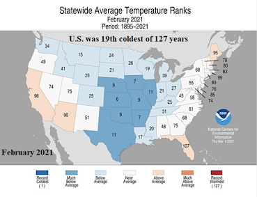
The February Statistics Are In

 February, 2021, was the 19th coldest February of the last 127 years. 

Hopefully, the South is near recovering from last month's extraordinary cold, snow and ice. 

Sunday, March 21, 2021

Sunday Fun: Laff-O-Gram Building

Did you know Walt Disney began his career in Kansas City?

The building is known as the Laff-O-Gram Building which is in reference to early Disney cartoons that were short subjects before movies. 
I rubbed my hand on the doorframe in homes that a couple of his molecules of genius would rub off on me. 

There is an effort to try to make it and/or other of the Disney buildings (his home, for example) into a museum. You can learn more, here

This is Tornado Bait

While tornadoes do not aim for mobile homes, it is true they are more dangerous than conventional housing. I would say these, as depicted, are even more dangerous than a conventional mobile home. I would not recommend these if you live in an area where tornadoes are frequent unless there is an underground shelter very close by. 

Saturday, March 20, 2021

Global Warming: Is There Anything It Can't Do?

From the Wichita Eagle:

This is a preposterous story written by a reporter "embedded" with the Eagle to write global warming scare stories. 

Let's deal with the contention that Wichita is third worst. Here is the money quote

In other words, this isn't even about pollen or air pollution. As usual, it is a MSM scare story about a warmer climate. 

The longer growing season is one of the best aspects of a warmer climate and it has been essential to feeding a hungry world.