Mindy and I would wish everyone a wonderful 2014!
Tuesday, December 31, 2013
Happy New Year!!
A White New Years
It looks like the Northeast will usher in a white 2014. AccuWeather has details here.
There are no airline delays at the moment. They have issued waivers ahead of the storm, so you can leave early without penalty. Here are two brief articles about how to take advantage of the waivers to avoid the storm: #1 and #2.
The Weather of 2013
This is a great video that recaptures some of the weather of 2013.
For me, the most scientifically interesting item of the year was the El Reno Tornado of May 31. Not only did we lose three highly professional storm chasers, that giant storm with its nearly 300 mph winds will have meteorologists studying it for years.
And, again, Mother Nature frustrated the global warming doomsayers by refusing to warm earth's atmospheric and sea surface temperatures. Of course, the rest of us found that to be good news.
Unfortunately, there is no way to forecast the weather or climate for 2014. But, rest assured that weather science will be working to keep you informed and your family safe in the new year.
For me, the most scientifically interesting item of the year was the El Reno Tornado of May 31. Not only did we lose three highly professional storm chasers, that giant storm with its nearly 300 mph winds will have meteorologists studying it for years.
![]() |
El Reno Tornado. Wikipedia |
Unfortunately, there is no way to forecast the weather or climate for 2014. But, rest assured that weather science will be working to keep you informed and your family safe in the new year.
Monday, December 30, 2013
The Immorality of Current Global Warming Spending
Again in 2013, the world experienced another year where temperatures were well below predicted levels, in spite of ever-rising levels of carbon dioxide.
Now, after a decade and a half of no real warming and temperatures remaining far colder than forecast, we taxpayers can, and should, ask whether governments should continue spending huge ($165 Billion and climbing) amounts of money on something that may not even be a serious threat.
When I saw this piece at climate scientist Dr. Judith
Curry’s blog earlier today, I thought my readers would find it interesting. It includes this link to a paper by Rafaella Hillerbrand and Michael Ghil on the morality of huge global warming expenditures.
Societies (or other subjects) are
able to part only with a certain amount of money or other resources for
predominantly altruistic goals, of which the mitigation of major
changes in future climate is only one. Investing in the mitigation of
climate-change effects means forgoing other investments, e.g. the
reduction of world poverty, towards which we have a moral obligation. For
example, on the one hand, the Stern report famously mentions 1% of global
gross domestic product (GDP) as the sum needed to avoid major hazards
that may arise from climate change. This amounts to an investment of
US $ 450 billion per year, if we base the calculation on the current GDP
value. On the other hand, current estimates of the money needed to provide
80% of rural populations in Africa with access to water and sanitation by
2015 amounts to only US $ 1.3 billion per annum.
So, increasing the already proliferate spending on global warming to a mind-numbing $450 billion per year versus $1.3 billion per year to bring clean drinking water and modern sanitation to most of the people in Africa who need it.
Which is the more worthy cause?
According to UNICEF, 6,000 people, mostly children, die each day in Africa from waterborne diseases and poor sanitation! Put another way, by spending 0.29% of the proposed spending on global warming for a speculative goal (we can really control the weather?), we could save 80% of those deaths by using proven technology!
Think about that number: 2,200,000 lives saved
for less than 1%
of what we are spending on global warming.
Right now, during the Antarctic summer, we have a bunch of global warming zealots stuck in the ice because they believed their own propaganda about the ice shrinking when it is really growing. Three ships have tried to rescue them without success. Think about the pollution this is adding to the region! Their rescuers have been put in harm's way because of the zealots' disregard for the scientific facts.
![]() |
The gray area is normal extent of Antarctic ice. The blue line, which is above normal, shows the current extent of the ice. |
Global warming is, by far, the biggest flood of gravy in the history of atmospheric science. Institutions, which would not exist if global warming is disproven, continue to sell an increasingly shaky hypothesis.
It is past time to reconsider how our hard-earned tax dollars are spent. Global warming research, as it is currently conducted, should be severely cut, not increased.
- Ramp up major efforts to understand how the sun and volcanoes affect our climate and see if we can forecast future trends based on these two effects.
- Cut about ¾ of current greenhouse gas-based research
- Take any savings and put them toward better weather forecasts and storm warnings for the public at large.
Those are my thoughts as we begin a new year.
Preliminary Snow Forecast
More from AccuWeather.
UPDATE: United Airlines has issued waivers. Here is how to use them: Part 1 and Part 2.
And, here is the forecast snow accumulation to 7am EST Thursday. More snow is expected to fall later Thursday. I'll cover that on the blog tomorrow.
UPDATE: United Airlines has issued waivers. Here is how to use them: Part 1 and Part 2.
And, here is the forecast snow accumulation to 7am EST Thursday. More snow is expected to fall later Thursday. I'll cover that on the blog tomorrow.
A Beautiful Scene
The light was hitting the Calder mobile just right this morning, so I thought I'd share the view with you. It is in the atrium of the Bank of America Building. AccuWeather Enterprise Solutions' offices are on the 7th floor.
Red Sky in Morning...
There is an old saying, "red sky in morning sailors take warning, red sky at night sailors' delight."
We rarely have red skies in morning in Wichita, so I thought you'd enjoy seeing this. And, no, we are not expecting any storms in Wichita the next 24 hours.
Sunday, December 29, 2013
Science: Reading "Warnings" Is Good For You!
Full story is here.
Warnings is written in the style of a novel (much like The Right Stuff, Isaac's Storm, or The Rocket Boys). Consider these reviews (in bold type):
'Warnings' is higly educational, but it reads nothing like a textbook. The writing is engaging and entertaining from cover to cover. Even if you're not yet convinced to buy it for yourself, if you know anyone with an interest in the weather, get it for them as a gift. If you're lucky, they'll let you read it when they're done.
Better storm safety would be a great New Year's Resolution for 2014. After reading Warnings, you'll be better able to protect yourself and your family when a major storm threatens and you will also be highly entertained.
To be quite honest it is the best book I've read in years. I couldn't put it down and read the whole thing in a day and a half. I highly recommend it to anyone looking for an exciting book where you can learn something, too.
Take that gift card or Christmas cash and learn why Warnings has a solid 5-Star rating at Amazon.
Sunday Feature: Maxine Powell, Queen of Motown
Two years ago, I had an amazing tour of "Hitsville U.S.A." -- the original Motown Studio where all of their great '60's hits were recorded. Here is my original report.
Great Britain's Guardian has a report on the late Maxine Walters who was put in charge of grooming Motown's young artists. She said the wanted them to be able to have an audience with kings and queens. I think you'll enjoy reading it.
Saturday, December 28, 2013
Record LOW Number of Tornadoes
Another Major Winter Storm After the Holidays?
I don't usually talk about storms more than about five to six days away but I think this is worth mentioning because the forecast pattern is similar to the Christmas Eve-Day that brought power losses from Oklahoma to Maine.
Here is the European model forecast for the 5th:
It depicts one vigorous storm over New Mexico and a second over Oregon.
The U.S. GFS model shows a single very powerful storm moving into Oregon.
It is far to soon to get specific as to what may occur. But, I want to let you know there is the potential for a major winter storm the second week of January.
Blizzard Warning
Orange is a blizzard warning currently in effect. Browns are high wind warnings. Winds may gust to 50 mph in these areas. The medium blue is a travel advisory for snow and wind. The lighter blues are warnings of extreme cold (see below). In some areas, wind chills may drop below -50°F.
Friday, December 27, 2013
With that Christmas Gift Card
This informative and very entertaining narrative investigates some of the country's most devastating storms over the past fifty years. In looking to the past, the author shows the effort that went into eventually creating the national severe weather warning system.
--- Bookloons
Thursday, December 26, 2013
Top Weather Stories of 2013
![]() |
Will this twisted twister of May 19 make the list? |
UPDATE: Courtesy of Angela Binyon, here is a view of the above tornado from a second vantage point a few moments before it started twisting itself into a pretzel. Please see the comments for more info.
Wednesday, December 25, 2013
Continuing Ice Storm Disaster
According to news reports, more than 1,000,000 people from Oklahoma to Michigan to Ontario and then onto Maine are still without power from this past weekend's ice storm. Today's weather science can make all the difference between a storm that cripples your business or one that has minor effects.
AccuWeather's Enterprise Solutions group specializes in working with our clients to mitigate the effects of this type of extreme weather. You can read more here.
In addition, I teach seminars for businesses to learn how to protect people, property and profits. For details, contact Mike Smith Enterprises, LLC at (316) 204-9969 or mindy@mikesmithenterprises.com .
A Great Book for Your New Kindle or Nook
If you enjoy this blog, you'll love these books!!
The Kindle and Nook versions have additional color photos that are not in the print version.
And, only available in ebook (print version has sold out), is When the Sirens Were Silent. This book tells the story of the 2011 Joplin, Missouri, tornado that killed 161 people.
A Sparkling Wichita White Christmas
It is a sparkling white Christmas in Wichita. Hope you are enjoying the day wherever you are.
Just saw that NOAA says 41.7% of the U.S. is enjoying a white Christmas today.
Merry Christmas!!
From Mindy and me, I hope you and yours have a wonderful Christmas!
Here is some rather cool footage from the moon. It shows, for the first time motion-stabilized, footage from the Apollo program. You'll enjoy watching this video from another world.
Tuesday, December 24, 2013
North Central U.S. Travel Conditions
Nothing severe, but there will be some light snows.
The light purple is a travel advisory for light freezing rain.
Momma Mia!
AccuWeather Enterprise Solutions' weather-triggered marketing will insure you have what you need to serve your customers regardless of weather conditions.
Monday, December 23, 2013
A Much Calmer Week
With one exception, things are calmer than they were last week.
New England began receiving freezing rain on Saturday and it continues today. Deep purple is an ice storm warning. Light purple is a freezing rain advisory for travelers. The blue is a winter weather advisory for travelers due to snow.
This is the current snow depth map:
Finally, this is the forecast precipitation for the next 5-days.
Sunday, December 22, 2013
Sunday Fun: "Walking Around a T-Bone Steak"
A little rural Kansas humor from our friend Derek Klingenberg.
Weekend Storm Continues
Here are the current warnings:
There are 250,000 homes and businesses without power in southwest Ontario. The legend is as below.
Thirteen inches of snow fell in Great Bend, Kansas. Wichita officially had just over three on top of a quarter inch of sleet.
There are 250,000 homes and businesses without power in southwest Ontario. The legend is as below.
Thirteen inches of snow fell in Great Bend, Kansas. Wichita officially had just over three on top of a quarter inch of sleet.
When You are in Kansas Over the Holidays
Best sure and visit:
visitors descend hundreds of feet in a freight elevator and enter a world covered in glittering, geometric salt crystals.
The sparkling crystals during Kathleen and my visit last summer. The underground mine is remarkable.
And, for more to do, click here. And, these recommendations from The Boston Globe.
Saturday, December 21, 2013
Tornado Watch Until 2am CST
UPDATE: 8:42PM:
84,000 homes and businesses in Arkansas are without power due to thunderstorms' damaging winds earlier today.
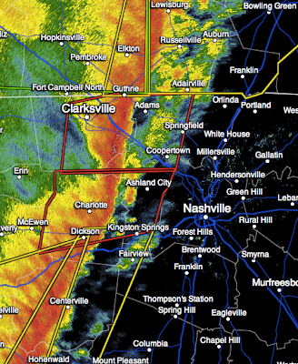
RADAR at 8:40pm shows a line of severe thunderstorms that has been producing tornadoes moving toward Nashville. People in and around Nashville should monitor local weather conditions closely!
ORIGINAL POST:
Numerous reports of damage from tornadoes and thunderstorm winds are being received this evening. Consequently, the NWS Storm Prediction Center has issued another tornado watch:
This does include Birmingham, Huntsville and Tuscaloosa.
At 8:22pm, the only tornado warnings in effect were in Tennessee (red polygons).
This is my last weather update of the evening.
Kansas City and Chicago Snow Accumulations
Kansas City region total snowfall.
Chicagoland snowfall as of 6am CST, a little more is forecast to fall.
Considerable Damage Reported
…due to a tornado(oes) in eastern Arkansas and northwest Mississippi.
Reports of homes destroyed, trees blocking highways, etc., from several locations.
At 6:57pm, the red areas are under tornado warnings and yellow tornado watches. Amber is severe thunderstorm warnings for damaging winds.
Dark maroon are flash flood warnings with serious flooding occurring in several areas. Bright green are flood warnings.
![]() |
KARK TV via Twitter |
At 6:57pm, the red areas are under tornado warnings and yellow tornado watches. Amber is severe thunderstorm warnings for damaging winds.
Dark maroon are flash flood warnings with serious flooding occurring in several areas. Bright green are flood warnings.
Warning Summary
- Red a tornado warnings
- Yellow = tornado watches
- Amber = severe thunderstorm warnings for damaging winds.
- Deep maroon are flash flood warnings
- Bright green are flood warnings
- Dark green are flood watches
- Dark purple are ice storm warnings
- Pink are winter storm warnings
- Blue are winter weather advisories for travelers
- Light purple are travel advisories for travelers due to freezing rain.
Addition: State of Emergency in northern New York due to the severity of the ice storm.
Radar Update at 3:20pm CST
Here is the latest AccuWeather Regional Radar. The purple area is a large region of freeing drizzle and sleet. The blue is snow, the darker the heavier. Strong thunderstorms now moving into Memphis.
11:10am Saturday: Storm Timing
1pm Saturday:
7pm Saturday:
The deep blues are snows with the darker blue = heavier snow. The patches of red in east central and northeast Kansas indicate there are still areas of freezing drizzle rather than snow.
However, by evening, most of the precipitation should be in snow across Kansas and northwest Missouri.
First Tornado Watch of the Day
The tornado watch is in effect until 6pm. Note there is a "moderate" risk of violent (≥F-2) tornadoes. The watch includes Houston.
Here is the latest radar as of 10:31am CST.
Please keep up on local weather information if you are in the tornado watch. Tornado safety procedures are here.
Here is the latest radar as of 10:31am CST.
Please keep up on local weather information if you are in the tornado watch. Tornado safety procedures are here.
Overview of Warnings
Photo of Ice Storm at Norman, Okla. from Jed Castles via Twitter
Warnings now in effect:
- Dark red counties are flash flood warnings. Do not drive into flooded areas by foot or by car.
- Light greens are flood warnings for rivers and streams.
- Hunter green are areas under a flash flood watch.
- Deep purple are ice storm warnings that now include Detroit and parts of New England
- Light purples are freezing rain advisories for travelers due to slick roads
- Pink counties are winter storm warnings, primarily for heavy snow
- Blue is travelers advisories for snow (lesser condition than a warning).
Here are the AccuWeather forecasts for snow accumulation this weekend:
Here are safety tips for ice storms and blizzards.
The AccuWeather Regional Radar at 8:45am. The precipitation near Amarillo will turn into the major snow storm this afternoon.
The area of southeast Texas and Louisiana is already being monitored for a tornado watch.
I will not be live-blogging the storms but I will update several times today. AccuWeather is live blogging the storms here.
Subscribe to:
Posts (Atom)