Monday, January 31, 2011

Extra Update 9:45pm

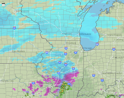
National Weather Service servers still having problems, so I'm doing this additional update.

Midwest Ice Storm
Radar at 9:20pm CST, click to enlarge this or any graphic
West Lafayette, IN has 1.5" of new snow, blue colors on the radar = snow. A mix of freezing rain and sleet are falling in the purple areas including Indianapolis, Dayton, and Columbus. The icing will increase during the night.  Serious power failures are quite likely in these areas. ADDITION 10:15pm, Power is out in the Terre Haute, IN area.

Oklahoma Ice 
Radar at 9:33pm
This is a large area of moderate to heavy rain with a few flashes of lightning. Current temperature in Oklahoma City is 25°, so this will cause icing before it changes over to snow. Very heavy snow is quite possible in Oklahoma and into Missouri more or less along I-44. Travel conditions will be nearly impossible in the blizzard area. ADDITION: Tulsa NWS just issued a forecast that power failures may occur from Muskogee through NW Arkansas including Bentonville and Fayetteville.

Everything else is unchanged.

The Rest of the Night

Bloggers are coached never to tell their readers when you are signing off. It supposedly "keeps you coming back." Kim and I respect your time, so here is the plan: This has been a very long day (been up since 3:30am), so this will be my last weather posting of the night. I have several other posts that I think you will enjoy during the pre-dawn hours. I had to push them back because of all of the weather blogging.

In the meantime, my friends and colleagues at AccuWeather will take great care of you for updated weather information.

See you tomorrow.

Mike

8:10pm Storm Update

Here is an ice storm map generated by Jesse Ferrell at AccuWeather
click to enlarge map
The small numbers are the amounts of freezing rain in inches and tenths. St. Louis is right on the 1" line and Indianapolis is predicted to have nearly 1.1 inches. Combined with wind, this would lead to multi-day power outages.

The National Weather Service advisories and warnings are unchanged from the last update. A lot has changed on the radar in two hours. Here is the 8pm radar from AccuWeather:
Thunderstorms have developed from Abilene, TX into southwest Oklahoma. These will spread north northeast during the night and change to into snow-producers after midnight.

The snow has increased in the Texas Panhandle.  Snow is just developing in southern Kansas (it is snowing in Wichita) and northwest Oklahoma.

The bottom line: The forecasts you read below are still valid.

6pm Update

The initial storm shown on AccuWeather radar at 5:55pm.
Blue = snow, darker is heavier snow.
Purple is freezing rain, darker is heavier.
There are confirmed reports of 0.10 to 0.15" accumulations of glaze ice in eastern Missouri into much of central Illinois. Indianapolis now reporting icy streets. Travel conditions in these areas are deteriorating rapidly with darkness and falling temperatures.  Ground stop in place for the Minneapolis airport, numerous flights delayed.


This is the main part of the storm getting better organized. Thunderstorms are developing west of Ft. Worth.

Thank You!!

Kim and I would like to thank you for being part of both the biggest and the biggest month in the history of Meteorological Musings.

While you are here, please take a minute to check the archives (at right).

Learn about the book.

Take a look at some beautiful weather photography.

And, see if there is an appearance in your area.

Thanks again for visiting!

Here it Comes!

The winter storm warnings are now in effect for Dallas-Ft. Worth all the way through Pittsburgh and Philadelphia through Albany and Boston. Airlines are canceling flights by the score. If you had plans to travel, please check the Airline Crisis Survival Guide.

Here is the map of winter weather warnings.
Map updated 4:35pm. Orange = blizzard warning.
Pink = winter storm warning. 
Here is AccuWeather's snow forecast map. The red areas are areas where ice is forecast to accumulate. Note: Some snow will fall on top of the ice in the Dallas-Ft. Worth area.

Serious icing is expected in the St. Louis and Indianapolis metropolitan areas which will likely extend east across Ohio and into Pennsylvania.

From around Detroit to Kansas City to Wichita, strong winds will cause major drifting and whiteout driving conditions. Here is an AccuWeather map of forecast peak winds:
Highest winds in Missouri and Illinois will be more than 40 mph
causing serious power problems in the ice storm
areas and drifting the snow with blizzard conditions.
Finally, the wind chills will be brutal and life-threatening should you get stuck driving.  Here is AccuWeather's wind chill map for Tuesday:
Purple colors are wind chills colder than zero degrees.
Winds chills colder than -20°F will be common from
Kansas north to the Canadian border. 
If you are in the affected areas, please take this storm seriously!

NWS Computer Problems

The National Weather Service's Central Region is apparently having computer problems

There have been times when their web sites have been completely inaccessible, perhaps due to heavy traffic. AccuWeather is up and running fine.

I'll do an extra update this evening so make sure you have the information you need.

It Begins

Here is the AccuWeather Radar from 3:05pm Central time:
Blue shades = snow, darker shades are heavier snow. Purples and maroons
are freezing rain and sleet.
Minneapolis has one hour flight delays.  The ice storm has begun from the Lake of the Ozarks through St. Louis and into east central Illinois. The NWS in Indianapolis is warning of a "catastrophic" ice storm.  I expect flight delays to begin at the Chicago airports in a few hours as the snow moves in from the southwest.

Meanwhile, to the southwest, the main winter storm has just begun to get underway:

Winter storm warnings are now in effect in a continuous band from New Mexico to Vermont. I'll have a full update in about an hour.

Winter Storm Bingo!

Upper half of a winter storm BINGO card
The St. Louis Post-Dispatch has a great game for a winter storm. By clicking here, their web site will generate a "BINGO" card with various winter phrases and cliches used by TV meteorologists. And, you don't have to be in St. Louis to play. It will work equally well in any TV market.

Don Phillips on the TSA

The March 2011 Trains has an article about the TSA by Don Phillips, America's number one transportation reporter. It is on page 8 and it is well worth reading regardless of what mode(s) of travel you prefer.

10:30am Winter Storm Update

The huge winter storm is still just about as forecast yesterday. As you view the forecast, please focus on the general pattern and not the small "squiggles" in lines and amounts.

Let's begin with the ice storm. The first map is storm total ice accumulation:
Darker shades of purple = heavier accumulations of glaze ice.
We already have roads that are slick in spots in eastern Kansas and northwest Missouri due to freezing drizzle. The significant freezing rain will be tonight in Missouri, Oklahoma and Arkansas then spread east.

The snowfall map is below. Blizzard conditions are likely in many areas.
The heavy snow will begin in Oklahoma tomorrow and then spread east northeastward. The predicted areas of heaviest snows shifted just a bit from last night. I am very concerned about traffic on Interstate 44 tomorrow as the snow will fall very quickly and may be on top of glaze ice. This could be a real mess as will Interstate 70 later and then the central and northern Illinois interstates all the way to I-64 to Indianapolis by Wednesday morning.

How much of a gambler are you? This is a map of the probabilities of 8 inches or more of snow from 6am Tuesday until 6am Wednesday (note, probabilities go up in the eastern part of this area during the day Wednesday.
Probability of eight inches or more. Blue 10%, green, 40%,
and red 70% chance. 

This is SO True

Best Wishes to Our Egyptian Readers

Google's tool for tracking the nation of origin of our blog's readers show that people from Egypt are reading right now (along with India, England, Germany, Finland, France, Australia, and Canada).

To our Egyptian readers, please know that the many friends of your great nation wish you all the best in this difficult time.

Know A Student Interested in a Career in Weather or Climate?

Article about Student Career Experience Program in the
December, 2010, "Bulletin of the American Meteorological Society"

The American Meteorological Society has publicized a wonderful program for students interested in the atmospheric sciences as a career. It is called the Student Career Experience Program and is sponsored by the federal government. More info is here. If you know a student with an interest in meteorology in general, or the National Weather Service in particular, please check this program out.

Sunday, January 30, 2011

10:45pm Sunday Winter Storm Update

This is what it actually looks like (the car in front of me has its lights on) to
drive in a whiteout. Don't do it! Whiteout conditions
are possible in many areas with this storm.
Things look pretty much on track tonight. Here is a forecast of snow depths from now through Thursday morning. It is important that you not focus on every squiggle and realize that amounts could easily be an inch or two on either side of the depicted values.

I still expect blizzard warnings (farther east, watches) to be issued for much of the dark blue-pink-red-gray colored areas with winds gusting above 40 mph and some gusts above 50 mph causing severe blowing and drifting. Remember, the major snow starts in the southern Plains late Monday night and Tuesday and will spread east from there.

With regard to ice, here is the latest. Again, do not focus on exact details, please focus on the overall pattern.
Darker colors = more glaze ice accumulation.
I believe this will be a major ice storm, especially from Missouri to central Ohio with widespread and possibly long-lived power outages.  If you are in these areas, please prepare for the possibility of several days without power in very cold weather!


Outside of the northern Plains where a separate storm will cause 1 to 3" amounts tonight through Monday, many areas will have tomorrow to prepare for the storm. 


This is going to be my last update on the storm until midday Monday. AccuWeather will continue to update later tonight and Monday morning.

Between now and then, we'll have a number of interesting posts, including one for your student interested in a career in meteorology.

What is Next?

As the winter storm slowly gathers force you might wonder what meteorologists are doing right now.

Many of us are eating dinner because the last "forecast cycle" is complete. The rest were launching weather balloons about an hour ago and are finishing tracking those flights as I write this. That data above the surface is vital to getting the forecast right.

In about 15 minutes, the National Weather Service weather balloon locations, as well as locations throughout the world (the balloons are launched simultaneously) will be reporting the results of the temperatures, humidities, and winds aloft.  Those will be ingested by computers in Washington, D.C., Montreal, outside London, and other weather centers all over the world.  Starting around 9pm Central, the first of the computer model forecasts for the next cycle will come out, with additional model forecasts from then until midnight.

If you want to know more about how all this works, I suggested reading Warnings: The True Story of How Science Tamed the Weather.  

Winter Storm Update, 6:36 pm CST Sunday

The National Weather Service in Oklahoma City calls the storm,

"LIFE-THREATENING" 

The National Weather Service in Chicago says,

WITH GUSTS UP TO 45 MPH.
THIS COMBINED WITH HIGH SNOWFALL RATES WILL PRODUCE LIFE- 
THREATENING
SITUATIONS WITH WHITE OUT CONDITIONS.
Notice a common theme? That theme applies to everywhere in-between that will be affected by this storm.

Below is a map of current winter weather advisories as of 4:06 5:36pm CST Sunday. The winter weather warnings are for snow except for the areas where freezing rain (glaze ice) is indicated (see below).  I expect a number of these to be upgraded to blizzard warnings tomorrow for the storm which will begin late Monday night and Tuesday in the Plains then spread east.  
Light green, blizzard watch; pink, winter storm warning; purple, winter weather advisory
(less serious than a watch or warning); hunter green = winter storm watch.
Here is AccuWeather's 48-hour ice storm forecast:
The darker pinks and purples = more ice. St. Louis, Indianapolis
and Dayton are at risk for an ice storm. This may extend
well into Pennsylvania at midweek. 

This storm is so vast that, by the time it exits into the Atlantic, AccuWeather's Alex Sosnowski estimates that 100,000,000 people will be affected. AccuWeather will have the earliest updates tomorrow morning!


There was a horrible blizzard in 1888 in the northern High Plains known as The Children's Blizzard. Here is how Wikipedia describes it:

What made the storm so deadly was the timing (during work and school hours), the suddenness, and the brief spell of warmer weather that preceded it. In addition, the very strong wind fields behind the cold front and the powdery nature of the snow reduced visibilities on the open plains to zero. People ventured from the safety of their homes to do chores, go to town, attend school, or simply enjoy the relative warmth of the day. As a result, thousands of people—including a significant number of schoolchildren—got caught in the blizzard. The death toll was 235. Travel was severely impeded in the days following.

We have a sophisticated warning system now. Don't let the very mild weather (central and southern Plains) of the last few days fool you. While we don't have every detail as to locations and amounts nailed down yet, this will be a huge winter storm. Prepare accordingly.

And, if you are outside of the affected areas, do not try to travel by air or by auto into them. This is one of those cases where you could be stuck at the airport for days. If you already have tickets, follow the steps in the Airline Crisis Survival Guide. Update at 5:36pm Sunday, airline waivers have been issued for Chicago (here's United's) and more will likely be issued in the morning.

Pending Blizzard and Ice Storm

Here is a map of the probability of 2" or more from now until 6am CST Monday:


Two low pressure systems will combine to produce ice storm, heavy snow, and blizzard conditions starting tomorrow and lasting into Thursday in the Northeast. This one looks like a very big deal!


Wind gusts of 40 to 50 mph are likely in the heavy snow region causing blizzard conditions.
Four inches or more of snow = "heavy snow'
Map from: accuweather.com
With regard to the ice storm, wind gusts of 40 mph will cause power and tree problems. Preliminarily, the heaviest ice may fall in a 50-mile or so band centered around Coffeyville, KS to St. Louis to Indianapolis. Some of those areas may have heavy snow on top of the ice.

I expect to post more information on this storm late this afternoon or this evening. The low pressure system in the upper atmosphere is now inland and will be better sampled so the forecasts can be more specific.

A suggestion: If you are in the ice storm area, it can't help to be prepared. Fill you gas tank (filling station pumps run on electricity), have fuel for your generator (if you have one), go to the grocery store, etc. If this forecast is correct there will be multi-day power outages in some areas. 

If you are in the heavy snow area, a trip to Lowe's might be in order if you need a snow shovel, snow blower, ice melt, etc. Beat the crowd!  If the forecast is wrong, you'll have it for next time since there is a lot of winter yet.

Noon Update: The National Weather Service has issued a blizzard watch for Chicago. The airline hub at Detroit will also be affected by the storm. Be proactive! Here is the Airline Crisis Survival Guide.

Why Forecasts Vary

BUMPED TO TOP:
There are so many questions about the pending winter storm in the 
central and eastern United States, including "forecaster X says 
one thing and forecaster Y says another" that I thought I would bump 
this posting to the top.


I have received a TON of emails and Facebook comments/complaints today pertaining to the great disparity of forecasts for the developing storm in the East. Apparently, there are cities where the current TV forecasts vary from “rain only” to “12 inches of snow.” I’d like to take a moment to explain why this is sometimes the case.

There are four techniques commonly used to forecast the weather:

  • Computer models
  • Scientifically valid derivative techniques
  • Experience
  • Instinct
The computer models can have wide disparities. Take a look at these three models all current and valid at the same time:
5km model. For D.C., 8 - 11 inches. Parts of Delaware, 15-19 inches. 
ARW WRF model. D.C. 8 - 10 inches. The same part of Delaware, 10-14". 
NAM model. D.C. 5-7 inches. Delaware 5-7 inches. 
Scale. Click to enlarge scale or any of the maps. 
While the range in model forecasts above for the District of Columbia could be reasonably stated as 5 to 11 inches (although some will complain that range is too wide), in Delaware the range in these three models is from 5 to 19 inches! And, there are many more models than are shown here.

So, how does a meteorologist make a determination as the final forecast?

One way is to use derivative techniques. Without getting technical, there are a number of techniques to try to assist with improving on the models or choosing between the models such as relating the path of heaviest snow to the path of the  500mb vorticity maxima, 200mb temperature advection, etc. Your local meteorologist might or might not be using these.

Experience. What are the biases in the model? For example, in early spring, experienced Kansas meteorologists know the Gulf moisture usually replenishes farther east than the models indicate, thus the thunderstorms form farther east than a simple model technique indicates. The human can improve the forecast by using experience.

Finally, instinct. I knew, every bone in my body knew, that if thunderstorms were able to develop the night of the Greensburg tornado, they would be very severe with large tornadoes possible. I can’t tell you why I knew, but I did. Really good forecasters develop a knack for forecasting. 

There are so many ways meteorologists can weigh this information that it is surprising the forecasts don't vary more. 

How can you make sense of all of this?

I suggest that people informally keep track of the accuracy of the various weather sources for a month or so and then select one or, at most, two. For example, if you are in one of the cities where this disparity is occurring jot down the various forecasts and compare them to what actually occurs. Do this the next several times the forecasts vary. If there is a clear winner, you have your answer. 

You will be better served by choosing the more accurate forecast and sticking with him/her/it (obviously, we hope you choose AccuWeather). If you try to follow the weather hour by hour and sort all this out yourself, you'll just drive yourself crazy!

Finally, if you have found this interesting, I guarantee you'll enjoy Warnings: The True Story of How Science Tamed the Weather

Metrology, not Meteorology

The standard kilogram
Meteorology is the science of weather and the atmosphere.

Metrology is the science of measurement. Sound boring? This fascinating (and easy to read) article from The Wall Street Journal will likely change your mind. Note: subscription may be required.

Saturday, January 29, 2011

Big Storm Coming! The Question is Where

I'm getting LOTS of messages tonight about the forecasts for a big storm. I advise people not to pay too much attention to winter storm forecasts until about 48 hours before the storm is expected to start in your location.  The big snows are still more than 48 hours away from the central U.S. so I haven't made a forecast.

I just re-posted this image and circled the location of the low
pressure system for non-meteorologists reading the blog.
If you are wondering why we can't pin it down yet, it is because the storm is still not over land. The center of the storm is the inner-most "comma-shaped" cloud band off the coast of Northern California.

It seems that until the storm can be sampled by the land-based weather balloon network, the forecasts tend to be very inconsistent.

Ahhhhh..... Day 3


Mother Nature is certainly making Kansas' 150th anniversary memorable!

Unfortunately, in January, temperatures that go up in Kansas must come down. See posting below.

More Dismaying News About Science and Kids

More about the terrible state of science (and engineering) among America's children:

Only one or two students out of every 100 displayed the level of mastery that the federal panel governing the tests defines as advanced, the government said.
“I was rather dismayed at the relatively lackluster performance at the top of the achievement levels,” said Alan Friedman, a former chief executive of the New York Hall of Science who sits on the board that oversees the federal tests.
Details here.

So, how did I get interested in science and make it my life's work?

The first part was fate. The day after the Ruskin Heights tornado my mom drove me through the damage and I was fascinated by what nature brought.
View of debris from Ruskin Heights tornado. Circled is 109th street.
This is the exact view I had as we drove down 109th.
Recently released photo from "Life" magazine archives.
But, that interest was sustained because kids in the late 50's and 60's could get toys that complemented that interest. For example, my friends and I loved my Alpha 1 Ballistic Missile:

Mix up some baking soda and vinegar, put it into the missile, put it on the launch pad, and pull the string. That baby could really fly!

Of course, any toy company attorney would have a cardiac over this toy today, even though it had a rubber tip that should have prevented any serious injury. My question: If a manufacturer threw in a pair of protective glasses (the only potential problem it could cause), isn't there some way to bring this back? 


Yes, there are various science kits on the market, but they are for kids in their teenage years. I believe we need something that an 8-9 year old can play with, learn something, and have fun with others. That will begin the interest that might turn into a career.

Major Change in Weather

At this time yesterday, temperatures in Wichita and the surrounding area were approaching 70°. That is coming to an end as Arctic air mass will overspread the region.
And, snow is going to overspread the region.  Stay tuned!

Today is Kansas' 150th Birthday

Today is the 150th anniversary of Kansas’ statehood.

I am not a native Kansan and, until I moved here,  I assumed that Kansas was “boring.” The “Wizard of Oz” has done a great deal to harm Kansas’ image and I bought into it.

I could not have been more wrong.

Kansas: The "Sunflower State"
The best part of Kansas is its people. Straightfoward, modest (often to a fault), unwaiveringly friendly, patriotic, and independent. Want an example? Just yesterday, Kathleen was reading the Wichita Eagle’s obituaries and this was published without any fanfare whatsoever:

Canzoneri, Helen Mary (Zimmerman), 97, died on November 18, 2010 at Larksfield Place. She was raised in Sterling and graduated from high school there. She earned her B.A. Phi Beta Kappa from Stanford University and an M.A. in Japanese history from Harvard University. She met her husband, Vincent, while working on her doctorate in Japan. The couple returned to marry in Sterling in 1936, then lived in Tokyo until September of 1941. During World War II, she taught Japanese at the Navy Language School and worked as a censor of Japanese mail in Honolulu, where Vincent served in Navy Intelligence. She raised three sons in Newton, where she was president of the Library board and, at the request of local parents, taught a pre-college enrichment course for high school students. She moved to Wichita in 1971, where her husband was an executive at Ross Industries. In Wichita, she taught weaving, helped to run the Blue Warp weaving shop, and served on the acquisitions committee of the Wichita Art Museum.

What an amazing life!

I know so many Kansans that have done similar amazing things, but they don’t boast about their accomplishments. Here, that is considered bad form.
Mesa in Kansas' Gyp Hills
One aspect of an independent outlook is the ability to see things as they might be -- which can lead to innovation. Think about the companies that have been started in just Wichita, not to mention the rest of the state:

  • Learjet
  • Koch Industries (world's second largest privately-owned corporation)
  • Cessna
  • Beech Aircraft
  • Pizza Hut
  • White Castle
  • Coleman (outdoor products)
  • Ryan International Airlines
  • Rent-A-Center
  • Air Midwest
  • Mentholatum (deep heating rub)
  • Vickers Petroleum
In the last few years, I sense that Kansas is growing in respect. This is due primarily to the large number of articles documenting the quality of life/cost of living here, how “surprisingly hip” (Fast Company magazine) Wichita is, recent articles about Kansas as a vacation destination, etc. I believe our best days are ahead of us. If you do decide to make a visit, I can assure you will be warmly welcomed.

So, Happy Birthday, Kansas! There is no place like home. 

Friday, January 28, 2011

"It's Global Warming...It's Global Warming..."

From University of Alabama
I've posted below about the outbreak of silliness pertaining to the claim that the East Coast snow storms this winter were caused by global warming/climate change/global swings, etc., etc. Here is one additional data point that further undermines their case: World temperatures this week are below normal. 


The above graph shows world temperatures (red line) as measured by satellite with the current value highlighted with the red box. The amber-colored line is the average temperature from 1979-2010.

How can it be 'global warming' when temperatures are below normal?

Hat tip: Watts Up With That

Biggest Week in the History of the Blog

This is the 1,500th post since the Meteorological Musings blog began in November, 2009. And, this week has had the most readers history of the blog and January, 2011, will be, by far, the biggest month in the history of the blog. Kim and I thank you!!!


While you are visiting, please take a look at the archives (listed at right) for anything that might be of interest. Please also feel free to visit the Mike Smith Enterprises Web Site, become a blog follower, look for upcoming appearances and book signings, and anything else that might be of interest.

Ahhhh....


while, at the same time...

UPDATE: 2:53pm CST: Since posting the above, Wichita's temperature has risen to 71°.

UPDATE:  Final high temperature was a record 72°!

Politicians Dealing With Really Important Matters

The Kansas State Capitol: Where we just spent $200 million to fix the
leaking roof and the roof still leaks.
Photo: Destination 360
The deficit? The war in Afghanistan? The poor showing in science among America's school children? These are the vital issues our elected representatives are fighting over, right?

Nope.

This is what the Kansas legislature is fighting over:

On Monday, state Reps. Tom Sloan, R-Lawrence, and Don Hineman, R-Dighton, introduced a bill to declare the fossil of the Xiphactinus audax the official fossil of the state of Kansas. The bill's genesis came from Sloan's constituents.

On Wednesday, Sloan said, he started hearing views that the more fitting state fossil was the pteranodon.

Hineman's heard those arguments, too, and he indicated Thursday there could be a change.


Lest you think this issue might fade away,

We're kind of in limbo right now. We may change the species of the fossil before we finish with that bill," said Hineman, who has hunted and found fossil specimens in western Kansas.

Sloan isn't keen on throwing the fish back in the sea.

"Frankly, what is going to happen is that people will suggest other fossils, confusion will reign among the legislators and nothing will happen," Sloan said.
Horrors!

The full report is here.

They Gave Their Lives for Science

We don't often think of scientists and engineers risking their lives for discovery and the advance of science. As a friend reminded me, today is the anniversary of two tragedies and another sad commemoration is Tuesday.

The first is the anniversary of the Apollo 1 fire, 43 years ago today.
The Apollo 1 crew. From left, Gus Grissom, Ed White, and Roger Chafee
A routine test was going poorly. Suddenly, a fire broke out. The cause has never been determined. Because of the poor design of the Apollo capsule, the crew never had a chance.

Today is also the 25th anniversary of the Challenger disaster. 
The plume of flame out of the right side of the light-colored solid fuel
rocket came from a non-sealed joint. The fire grew
and the Shuttle assembly disintegrated.
By this time it was thought shuttle missions were "routine" and the regular TV networks no longer carried them. We were watching CNN's coverage in WeatherData's office and, when we saw the explosion, we could not believe what we had seen. 

The weather played a big part in the shuttle disaster. Severe cold overnight caused an "O-ring," designed to seal a joint, to shrink. Because of the shrunken O-ring, the fire was able to escape the joint leading to the breakup. 

Finally, Tuesday is the 9th anniversary of the Columbia disaster. 
A defective heat shield, along with other flaws, caused the shuttle to break up in flight. 


Hat tip: Paul Mallonee

The Soup Sweetheart

One of the most iconic episodes of Seinfeld was "The Soup Nazi." You might recall that Elaine's knees buckled, the soup was so good.

In the late 1990's and early 2000's Wichita had its own soup restaurant, Tanya's Soup Kitchen. Run by entrepreneur Tanya Tandoc, I had never been a patron until a friend urged me to try it. Turns out Tanya's soups were knee-buckling good! In 2004, Tanya lost her lease and the restaurant closed.
Photo of Tanya (front) and her team.
Courtesy: The Wichita Eagle
Now, she is coming back at Phil Ruffin's Sunburst Plaza at 1725. Her new restaurant is expected to open this spring. The entire story is here.

I'll post when she reopens. And, the next time you are in town, you will want to stop by.

Thursday, January 27, 2011

Global Warming Meeting Cancelled Due to Snow

The Al Gore Effect is still at work:


Inclement weather has canceled a community workshop focusing on the local climate action planning process and energy conservation and sustainability.
“Carbon, Our Energy Future and You,” a joint conference planned by the University of Virginia, Charlottesville and Albemarle County, will be rescheduled for another date, as yet to be announced, officials said.
The workshop, originally scheduled for 6 p.m., is being postponed in the face of a predicted winter storm that could drop between 4 and 8 inches on Central Virginia, with the heaviest snowfall between 4 p.m. and 8 p.m.
Full story here

Vacation Weather

The current temperature in Wichita via my car's thermometer.

It will be at least as warm tomorrow. Come visit us!