Posts

Showing posts from August, 2023

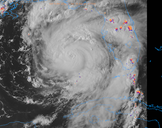
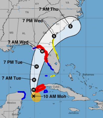
As Idalia Approached, NOAA's Hurricane Hunters Were Grounded

Image
This is simply unbelievable .  This is the result of many years of neglect through both Democratic and Republican administrators. I give President Trump a great deal of credit for trying to put well-qualified people in those positions but was stymied by Congress.  Since 1974, the National Oceanic and Atmospheric Administration has not had a  single  administrator with a background in weather science and it shows:  Tornado warnings are becoming less accurate;  The U.S.'s global forecast model, the GFS, is the worst  of the worldwide models;  Issues are starting to appear in our hurricane warning forecasts; It can't even acquire enough helium to fill its weather balloons! These are just some of the problems. Add those to the issues throughout the U.S. disaster forecasting and response community and there is absolutely no doubt of the need to create a National Disaster Review Board to evaluate these issues and give guidance to the pubic, the federal agencies, Congress, and future

Turn Around, Don't Drown!!

Here is some terrific advice about driving in heavy rain. With the Labor Day Weekend upon us, please give it a quick look. Thanks to the National Weather Service!

Evaluation of Forecasts of Hurricane Idalia

Image
This is our routine self-evaluation of the forecasts we present on this blue when major events occur.  The fact the forecasts for Idalia, at least as presented on this blog, were quite timely and accurate is important given some of the silly comments the last couple of days contending that hurricanes are less predictable due to global warming.  One Week Before Landfall Six Days Before and, then,  Four Days Before The forecasts unfolded normally after that time.  One forecast of note was the forecast of power outages.  That was the forecast. Here are the power outage maps as of a few minutes ago.  If anything, I underforecast the extent of the power outages. It will be days before everyone is back online.  I would rate these forecasts an "A."

Tornado Potential High

Image
The yellow area has an enhanced  risk of tornadoes. The brown area has a significant risk.

Hurricane Warning For Georgie and South Carolina Coasts

Image
Red is a hurricane warning and one is in effect for coastal areas of of Georgia and southern South Carolina. This includes Savannah. Blue is a tropical storm warning (40 to 74 mph).  At this time, Hurricane Idalia, after making landfall as a Cat 4, still has winds of 110 mph. It will still be hurricane force (75 mph sustained winds) when it reaches the coast.  The power outage map tells the story (time Central): Power outages are spreading into Georgia.

Important Post-Storm Considerations

Image
From the American Meteorological Society.....

Hurricane Idalia - Sheltering Advice

Image
Note the pressure continues to fall and sustained wind speeds (with stronger gusts) continue to strengthen.  The area in purple will have widespread damage and, near the coast, possibly catastrophic damage.  The winds in the purple area will be the same as a strong tornado -- shelter as if it was a tornado warning. Gusts to 150 mph are likely.  The storm surge -- which will reach 15' -- will be at least as deadly.  Winds will begin rising in the next couple of hours along and east of the path of the eye. 

Tornado Forecast From 8am EDT Wednesday to 8am Thursday

Image
Courtesy: Nadocast Brown is the significant value. Red is a high risk. 

11:25 pm EDT Idalia Update II

Image
There will be considerable damage to the power grid in the purple area. Expect power to be out for days. In the red areas, power outages will be somewhat less widespread and will not last as long but certainly areas will be without power for 24 hours or more. -- original text (below) is still valid -- The eye is quite visible. Winds are up to 110 mph and the pressure down to 960mb. Further strengthening will occur during the night.  The storm is expected to be a 130 mph Cat 4 at landfall.  Eye Path Forecast Remember, the most violent winds will be along and to the east of the  eye. The storm surge with be worst in those same areas. Sustained winds of 40mph or more will reach the coast in the region of landfall between midnight and 2am.  No change on the surge forecast. It will reach 15' in places. 

Tornado Watch Issued for Parts of Florida

Image
The tornado watch is in effect until 6am. It includes Tampa-St. Petersburg.  Meanwhile the barometric pressure has rapidly fallen to 960mb in Idalia while the eye has become well-defined. It is still moving slightly east of due north. 

6:30pm Bulletin on Idalia - Rapid Intensification Underway

Image
Radar 6:22pm. The eye has become well-defined with occasional lightning.  Data from weather satellite, Hurricane Hunters, and coastal radar all indicate that "rapid intensification" (RI) is underway. The pressure in the center has continued to fall to about 967 millibars.  The storm's movement is accelerating to the north. I urge you to evacuate if told to do so and, if you are outside of the evacuation areas, finish your storm preparations. Wind gusts over the Florida Peninsula are currently gusting to 50 mph as far north as Orlando and The Villages and similar, or in some cases stronger, gusts will continue the rest of the night with squalls.  This will likely be a bad one. Treat it with respect!

5:15pm Tuesday: Strengthening Hurricane Idalia Heading Toward Florida Panhandle

Image
Satellite image from 5:07pm. Forecast essentially unchanged from below.  However, note the "H" near Waycross, Georgia. That indicates hurricane force winds will persist across the Florida Panhandle and into southern Georgia. The M = major hurricane and the S = tropical storm.  In addition to sustained winds of 125 to 130 mph near and just east of the center, there will be a (literal) killer storm surge.  The purple area of coastline is where a storm surge of 12 feet or deeper  is forecast to occur. You cannot survive this unless you are in a reinforced building well above. Note also that a 4 - 7 foot surge is forecast in Tampa Bay. Below is a time-of-arrival map for sustained 40 mph winds.  Evacuations and preparations should be rushed to completion. 

11:20am Tuesday: Hurricane Idalia -- DEADLY SURGE

Image
Key West radar at 10:37am E = Eye of Idalia An eye has formed in Idalia this morning and the storm became a minimal hurricane overnight. The stage is set for rapid intensification (RI) but that has not begun as yet as the storm is still "feeling" some wind shear. Satellite indications the last few minutes indicates RI may be starting. [Quick note at 11:33am. Lightning near the center indicates that RI may be starting.] The storm should be a 125-130 mph (strong Cat 3 speed) hurricane at landfall in the Florida Big Bend.  The National Hurricane Center's forecast has pretty much focused on the Florida Big Band and I agree. [UPDATED]  The storm surge will be deadly along and to the east of the point of landfall as it will reach to a depth of 15 feet. Imagine yourself at the bottom of a 15' deep swimming pool with the water flowing rapidly. Do you think you would survive? Tampa Bay is expecting a surge of 4 to 7 feet, which is a major problem. Please note that, back of 18

11pm Idalia Update

The storm is lingering near the west tip of Cuba. It is still a tropical storm with 70 mph winds and a central pressure of 983 millibars.  It is still forecast to make landfall with sustained winds of 120 mph in the Florida Big Bend area with a life-threatening storm surge.  This is my last update for the night. 

5:05pm Forecast for Soon-To-Be Hurricane Idalia

Image
The satellite image of Idalia show it attempting to create an eye as of 4:26pm. This is a further sign of strengthening.  Wind Forecast This is the National Weather Service's digital presentation forecast of the wind gusts associated with Hurricane Idalia.  Please note the proximity of 70 mph wind gusts to Tampa Bay. There will already be a storm surge into the bay but if either the wind field should enlarge or the storm take a track even slightly farther east, then then conditions may be worse than forecast.  Below is the earliest likely time of arrival of 40 mph winds.  H = Hurricane. M = Major Hurricane. S = Tropical Storm. Anyone in the hurricane warning (red) area should be prepared for winds of 70 mph or stronger.  Storm Surge Forecast Storm surge warnings are in effect! Life-threatening surge likely.  From the National Hurricane Center: Inundation of 8 to 12 feet above ground level is expected somewhere between Chassahowitzka and Aucilla River. Residents in these areas shou

Hurricane Warning For Florida: Idalia, 12:25p Update

Image
Extremely dangerous, soon to be hurricane, Idalia heads toward Florida.  The storm now has sustained winds of 65 mph and its pressure is down to 990 millibars.  H = Hurricane. M = Major Hurricane.  Maximum winds will be in excess of 115 mph at landfall. Red is the hurricane warning area. That includes Tampa Bay which may experience hurricane-force winds and will experience a storm surge.  Storm surge will drown you, if you are in its path. It will be 7-12', not counting tidal effects. That means if you are 6 feet tall, the water will be over your head.  Here is a breakdown of risks.  Please note that 110mph winds are possible in western part of the Tampa area, including Clearwater Beach! There is a tornado risk, which is highest in the brown area.  There will be localized flooding. However, the area has been in a mild drought which should work to mitigate the worst of the flooding possibilities.