
Another Shocking Tornado Warning Miss By the National Weather Service
Earlier this evening, we had a shocking tornado warning failure from the National Weather Service about 35 mile northeast of Kansas City. Essentially, the tornado warning program of the NWS can no longer be depended upon to keep the American people safe from tornadoes.
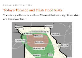
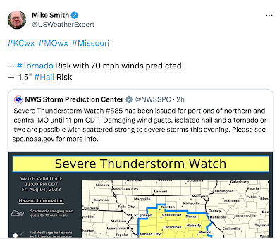 I tweeted the NWS's forecast of a risk of tornadoes along with large hail and damaging winds for northern Missouri.
 He is not a meteorologist. So, perplexed, I excused myself. When I looked at the data, I couldn't believe what had and was occurring.
 The Doppler radar wind velocity data over Ray County, Missouri, showed rotation rapidly increasing compared to the data over the previous ten minutes (not shown). A tornado warning could have been issued at this point. Had I been working the WeatherData, Inc. warning desk for our client in Ray Co., I would probably (but not definitely) have warned at this point.
 As we have discussed previously, the circled item is a "tornado vortex signature" and it called for a tornado warning. Update: Per the NWS's damage survey, this is when the tornado touched down. It did cause significant damage.
Here is a timeline of this failure.
12:02pm.
I posted the NWS's Storm Prediction Center's forecast of tornadoes in northern Missouri on this blog.

5:21pm.

We have family from out of town this weekend. I was playing with my model trains with my grandson when I received this text message from a friend who lives in Washington, DC.

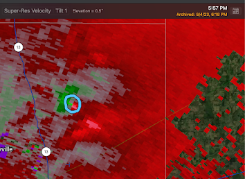
5:56pm

5:57pm.
I appreciated the Kansas City NWS operating their radar this evening on tornado mode (80-second intervals). This had been a huge problem in 2022.

Unfortunately, one would not be issued by the NWS for another 9 minutes. Put another way, it is likely the "lead time" on this warning was about negative nine minutes. This contrasts with the NWS's published goal of +13 minutes. The latter would not have been possible today but, certainly, 1-3 minutes advance notice appears to have been attainable.
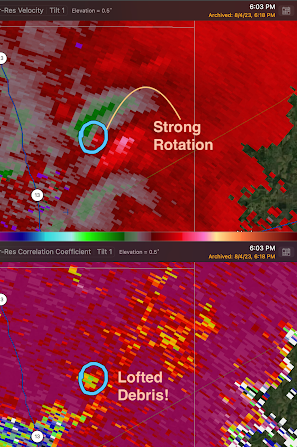 Dual-polarization radar clearly showed lofted debris at 6:03pm along with strong rotation. Yet, the tornado warning -- even though debris was being lofted into the atmosphere -- would still not be issued for another 3 minutes!
.png) Here is my concern: The lofted debris "confirmed" the tornado. The NWS's social scientists say when it can be stated a tornado is "confirmed," people are more likely to take notice and act. "Radar indicated" is considered less persuasive.
Here is my concern: The lofted debris "confirmed" the tornado. The NWS's social scientists say when it can be stated a tornado is "confirmed," people are more likely to take notice and act. "Radar indicated" is considered less persuasive.
 The tornado vortex signature was again present with considerable debris was being lofted. Easy "confirmed tornado" warning situation.
 Note the more persuasive statements: confirmed tornado, radar confirmed tornado, tornado on the ground.
 In that case, the KC NWS office operated the radar at seven minute intervals -- especially since it was ~1:20 in the morning, a violent tornado like Joplin's could have gone undetected and unwarned for precious minutes.
We Skip Forward to 6:03pm

6:06pm
The first tornado warning of the day; but it is less than ideally worded.
.png)
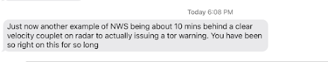
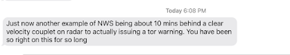
6:08pm
The message that got me looking into this.

6:09pm

6:10pm
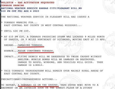
The importance of the stronger language is evident by the KC NWS, just four minutes after the original Ray County tornado warning, issued a "radar confirmed" tornado warning for the same area. That is how important the stronger language is considered to be.

There were other reports of tornadoes in northern Missouri this evening. I have not analyzed those. Suffice to say, this was yet another poor performance by the KC NWS with an unwarned tornado -- the second in less than 14 months.
I am hopeful there were no injuries and little, if any damage.
What Are the National Weather Service's Priorities?
In addition to this shocking failure, there was a tornado miss in Easton, Massachusetts, six evenings ago (July 29). These failures have become so common that I don't wish to bore my readers who are not meteorologists, emergency managers or policy makers.
But, meteorologist or not, the nation counts on the NWS to provide accurate and timely tornado warnings. It is clearly failing to do so, especially compared to 15 years ago when accurate tornado warnings were routine. That's right: if you are new to these discussions, the quality of NWS tornado warnings was much better from 2000-2011 than they are today.
The fact today's miss happened in a rural area is irrelevant. Evidently, the NWS suffers from meteorologists who cannot adequately interpret a radar in the context of tornado warning decision making. The KC NWS's missed tornado warning of June 8, 2022 occurred in the densely populated area of south Kansas City. Roughly 3/4ths of the tornado's path unwarned (see below).

The solution to all of this, since the NWS says it does not have a tornado warning problem, is a National Disaster Review Board (NDRB) modeled after the highly successful National Transportation Safety Board. The NDRB would also take over warning accuracy statistics from the NWS. Right now, the NWS investigates itself and keeps the scorecard -- hardly conducive to accurate scorekeeping.
Please write your congresspeople about this -- today.
P.S. Television meteorologists: I urge you to brush up on your radar interpretation skills. It is incumbent on you to "backstop" the NWS during tornado situations.
Comments
Post a Comment