Posts

Showing posts from September, 2017

There Was Plenty of Warning For Puerto Rico With Regard to Maria

Image
Stop the Accusations. We Need a Different Approach, Now!! The amount of nonsense on Twitter and Facebook today with regard to Hurricane Maria and Puerto Rico is becoming nonsensical (pun intended). Now, it is being charged that PR didn't have enough warning. Let's review. My friend, John Morales, has already put together a composite image of the four days of warning for Puerto Rico. As John points out, the National Hurricane Center issued 17 forecasts, beginning four days in advance, all informing Puerto Rico the Maria was going pass over the island. Sixteen of those predicted it to be a "major hurricane" when it did. This blog forecast the following the day before it hit: "severe to catastrophic damage." Even though it is my opinion there is lots  of blame to go around, the politicking, rudeness, and grandstanding needs to cease. Having examined the aftermath of many hurricanes and other disasters, it is my opinion that President Trump, regar...

"Wall-Mart Stories Flew in Satellite Phones to Communicate With Its Store Managers"

So said yesterday's  Wall Street Journal . Of course, with much of Puerto Rico's road network in shambles, it will be difficult getting the phones where they are needed. Anyone who has been to one of my presentations on weather risk mitigation (I'm doing one for Wichita State University's logistics class Monday evening) knows that I am a huge fan of satellite phones. With both Harvey in Texas and Irma in Florida, there were interruptions to both the landline and cellular networks. With a satellite phone, you bypass all of that. Prices have dropped considerably in recent years. I don't own stock in any of the satellite phone companies, I recommend them because they are cheap communications 'insurance' when a natural disaster occurs.

Yes, It Can Get Worse

Image

Tsunami Brings Invasive Species to North America

This article has a really interesting premise. I want to caution it is not particularly well-written and its attempt to bring in global warming is scientifically incorrect. Nevertheless, it is worth reading.

Absolutely True!!

Image
Or, after a solar " Carrington Event ." Only it would be worse because Puerto Rico has the mainland United States nearby to assist. I've thought of this many times since Maria but am so busy with more urgent things that I have not had time to write about it. We have no ability to forecast a Carrington Event other than a few hours of warning. Who knows that North Korea will do? Here is a novel about such an event that I have read and find plausible. How would you protect yourself and your family if this happens?

Resilience as it Applies to Global Warming

This is a superb analysis by Dr. Cliff Mass on ways to improve reliance to all types of weather and climate extremes. While Cliff is focusing on the State of Washington, much of what he has recommended an be adapted elsewhere. One caveat: I do not believe there is any skill to regional climate modeling.

Warnings: Limited Supply Available

Image
Want to read a gripping (written in the form of a novel) story that takes you behind-the-scenes as meteorologists warn of hurricanes and tornadoes and keep airliners from crashing? And, takes you into courtroom during the one of the most important trials -- ever -- involving weather and what was once the #1 cause of airliner crashes unfolds? All of that, and more, is the topic of Warnings: The True Story of How Science Tamed the Weather .  The link will take you to the Kindle version of the book. The Nook version is here . The most recent Amazon customer review, posted hours ago. Please don't let the reference to "technology" scare you off. The book is written in the form of a novel and completely non-technical.  As you will learn when you click the green link (above), the book is officially out of print. Amazon is offering only used copies of the hardcover version. However, I have a couple of unopened cartons of book that I purchased from Greenleaf Book Group ...

The Federal Reserve's Disconnect From Disaster Reality

Image
Hurricane Harvey's floods in the Houston area Sheesh. For a long time I have believed the Fed does harm as often as it does good. While that is a topic for another day, here is an article that is excellent example of the Fed's disconnect with the real world economy: "GDP is a measure of effort, not standard of living," says David Ranson, director of research at HCWE & Co. "This is an egregious example of where the two are completely at odds." In other words, we as a country will work a whole lot harder just to get back to the situation where we started from in August before the two storms hit. That is to say, you start with a perfectly adequate house, then it gets trashed. So you rebuild it at great expense to yourself and with considerable effort by everyone involved. In the end, you get back a perfectly adequate dwelling. You are right back where you began, but having expended Herculean effort. It can hardly be considered economic...

Wise Words From Bill Hooke

For weeks now, hurricanes Harvey, Irma, and Maria have been schooling America, revealing our affluence to be a brittle one. We’re not resilient to natural hazards – a serious vulnerability, since we live on a planet that does much of its business through extreme events. Worse yet, what resilience we do enjoy in the United States has been declining, community-by-community, bit-by-bit, over decades. As Bill Hook, the author , points out, this should be -- by far -- the #1 new story. But the nonsense between President Trump and the NFL has foolishly been dominant.  I recommend Bill's column highly.

Some Wonderful News Pertaining to the Elimination of Disease

Public health is making real progress is being made. Details here .

Thank Goodness: Last Forecast Update on Maria

Image
Here is the latest forecast path from NHC. The storm is going to make a quick right turn and head out to the open ocean. Brown is the hurricane force winds. The orange is tropical storm (40-74 mph) force winds. Tropical storm force winds will likely occur on the North Carolina Outer Banks. The center of the storm, as forecast, will stay well away from land.

"All of the Above Energy"

The recent hurricanes show the wisdom of an " all of the above " energy policy.

Latest Rainfall Amount Forecast

Image
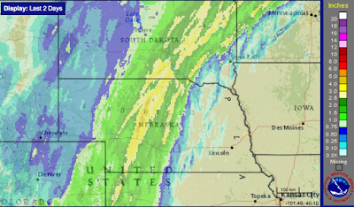
Here is the 2-day rainfall up to 1pm today. Please keep in mind that on the scale of this product, yellow = 2.5 inches. As much as five inches has fallen in a small area of far west Texas (the image immediately above). You can click any of the images and they will enlarge. Here is the updated rainfall forecast from 7pm this evening to 7pm Thursday. There is still the potential for flooding in west and south central Texas from these rains. Elsewhere, the rain will mostly be welcomed for agriculture and for water resource management purposes.

Sunday 11am EDT: Hurricane Maria Update

Image
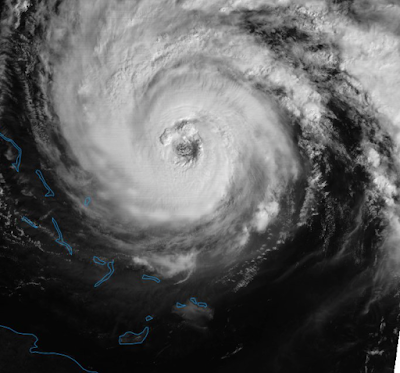
The latest satellite image is below. Wind speeds have dropped into the 95-105 mph range. Here is the forecast of the center of Maria. It is not forecast to make landfall. However, the storm is generating dangerous surf and rip currents throughout the coast. In addition, high winds will brush the Outer Banks.

Sunday Special: Diving into a Fire

Image
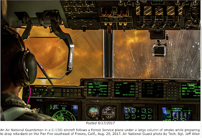
That is one of the most stunning photos I have seen. It is of a fire suppression aircraft diving into a fire's smoke plume to drop chemicals onto a fire.

Saturday: 11:40 EDT Maria Update

Image
Here is the latest forecast path of Maria. As it will be a hurricane off the North Carolina coast, the center is not expected to make landfall. That said, residents of the Outer Banks should be aware of the potential for high winds as the storm passes by. More on that tomorrow.

Rainfall Amount Forecast Update

Image
Rains have begun to fall from Minnesota to New Mexico. Here is the seven day rainfall forecast. A small area of 11 inches of rain is forecast to fall near the Rio Grande near Del Rio. Flooding is a risk in much of western Texas, especially in the Hill Country.

Saturday 10:10am Update on Maria

Image
Here an update on Hurricane Maria. M=major hurricane (Cat 3) and H=weaker hurricane. The storm is expected to slow and move closer to the United States than originally thought. 

Flood Threat in Texas; Need Rains in the Great Plains

Image
The Texas Hill Country south to the border are at risk of flooding over the next few days. Farther north, needed rains are forecast to fall on the central and northern Plains and Upper Midwest.

10:10EDT Saturday: Update on Hurricane Maria

Image
It is still out there, unfortunately. Cuba is at lower left. Here is the three-day track forecast. Beyond three days, there is a possibility the storm will come near the United States before moving out to sea. I'll update this evening with later information.

Did Meteorologists Fail in Forecasting Irma?

Some people seem to believe so (I won't bother to post all of the links). Here is my reply . I want to thank Slate  magazine. They were great to work with.

Please, Please Donate to Disaster Relief Services!!!

I cannot stress this enough. Puerto Rico and the rest of the Caribbean desperately  needs our help.  No power on PR for four to six months, a year to restore power to everyone.  Dominica flattened. Barbuda flattened. Severe damage to St. Martin.  I have done some research on which charities to donate. Please do your own research. But here are the ones Kathleen and I have donated to: Salvation Army for Harvey and Irma and for the Mexico earthquake .  United Methodist Church for Caribbean . Of course, Caribbean includes Puerto Rico. There was a news story yesterday about "donor fatigue" and I get it. But, if you have a roof over your head, three meals, sufficient water, electricity, and medical care you are far better off than the people in the Caribbean. Please  give as much money, over and above your normal donations, as you can afford.  Thank you. 

11:45am EDT Thursday Update on Maria

Image
Here is the latest satellite image of Hurricane Maria. Here is the forecast path of Maria. After the vicinity of the Turks and Caicos, Maria will move into the open ocean. It is no threat to the United States. As the purpose of this blog is weather forecasting and storm warnings  rather than news coverage, this will be the last update on Maria.

Why Don't Hurricane Hunters Fly Over Land?

Image
The Hurricane Hunters are incredibly important to the accurate forecasts of hurricanes. The National Hurricane Center wrote this yesterday afternoon. One of our readers asked me this question and while I thought I knew the answer, I wanted to be sure. So, I asked Dennis Felgen of the National Hurricane Center.  His answer: There is a lot of up and down and side to side pushing by the hurricane onto the aircraft (like being on a roller coaster in a car wash).  If the aircraft were to fly over land during this turbulence it would have to deal with the structures on the land and the variable terrain itself.  And that is too dangerous. 

8pm EDT Wednesday, Update on Hurricane Maria

Image
The mountains of Puerto Rico pretty well tore Maria apart but from satellite images, it appears to be regains organization and, likely, strength. Maria has taken a bit of a westward jog and it looks like it will move over or very close to the coast of the Dominican Republic. With the likely intensification, people in the DR will need to prepare for a major storm. Haiti will feel the outer effects but is not going to suffer a direct hit. Here is the 5-day hurricane forecast. I was asked on the air this afternoon, and elsewhere, whether I knew  Florida was safe from Maria. I am. I believe it is unlikely Maria will hit the United States but the effects of Tropical Storm Jose´ interacting with Maria make this forecast a bit tricker than usual. Besides, our ability to forecast hurricanes beyond about five days is marginal at best. So, relax for now and if you live in the Northeast, I'll let you know if/when it is time to be concerned.

A Blog Housekeeping Note

As you know, the policy changed a couple of years ago and I now delete blog posts pertaining to "routine" weather and storm warnings. However, I am going to keep the warnings for this year's hurricanes and related items in case some researcher might find them useful in the future. Also, a reminder that if you would like my full storm coverage, please follow me on Twitter: @usweatherexpert .

Hello Ft. Wayne

I will be on The Pat Miller Show  at 5:08pm on WOWO Radio in Ft. Wayne this evening. Please consider tuning in.

Catastrophe for Puerto Rico

Image
The eye of Maria is just southwest of San Juan. As feared, the storm took the worst possible path. As meteorologist Pam Knox said about this process a couple of weeks ago:  Being a meteorologist during these hurricanes is like being a passenger on the Titanic and seeing the iceberg ahead." The storm made landfall at 6:15am AST/EDT. The winds ahead of the eye caused both radars on the island to fail. Here is what the wind pattern looked like on the last image. San Juan circled at top. The radar shows widespread winds above 120 mph. Highest sustained winds were estimated at 155 mph. Now that the storm has traveled over land, the winds are estimated near 140 mph near San Juan (no radar image available). The latest satellite image is below. This is an utter catastrophe for St. Croix and Puerto Rico. They are going to require immediate and effect help that is going to cost a great deal of money.  Here is the three-day track forecast.

Here is the Weirdest Story in a While

Perhaps politicians should do some due diligence on their sign language interpreters .

10:55pm Tuesday Update on Maria

Image
As of 11pm EDT/AST, winds in Maria are 175mph. In mountainous areas and on the higher stories of buildings (i.e., hotels) winds could gust to 190 mph or higher. Severe flash flooding will occur.  Hurricane force winds are now occurring on St. Croix, US VI.  Revised time of arrivals: The eye will reach the southeast coast of Puerto Rico between 6:30 and 8am AST ( = EDT). 5:30am and 7am. The eye will reach San Juan about 2 hours later.  The damage will be catastrophic. Puerto Rico's government declared bankruptcy. I am hoping that will not retard relief efforts. Here is the radar image as of 10:45pm AST/EDT. Here is the satellite image at 10:15pm AST/EDT.

Houston NWS Meteorologists and What They Went Through During Hurricane Harvey

Image
HGX = National Weather Service in Houston. Yes, meteorologists -- surprisingly often -- are heroes in the full definition of the term. Hat tip: NWS Houston and National Weather Assn.

8pm EDT, Maria Update

Hurricane Maria's sustained winds are now 175 mph with a minimum pressure of 909mb. It is one of the 10 strongest hurricanes in the history of the Atlantic Basin. Its path forecast is unchanged. Addition at 9pm: At the current rate, the eye would be near San Juan around 9a-Noon Eastern Daylight Time which is the same as Atlantic Standard Time (the local time in Puerto Rico).

Update on Hurricane Maria, 5:10pm EDT, Tuesday

Image
Here is Category 5 Maria's forecast path for the next three days: Keep in mind that orange is sustained winds of 40-75 mph and brown is winds of 75 mph or higher. This storm has sustained winds of 165 mph! It is going to moved across the US Virgin Islands tonight and Puerto Rico tomorrow with severe to catastrophic damage . It would not surprise me if some parts of PR are without power for a month or more. Your own food and water will be essential. A hurricane warning is out for the northeast Dominican Republic. A hurricane watch is out for the Turks and Caicos Islands. Here is the radar at 5pm EDT. For a wider view, here is the satellite image at 4:45pm EDT.

Genuinely Hate to Say, "I Told You So"

No one likes to read someone else's boast but this one is scientifically important: A new, peer-reviewed, study shows the earth is warming slower than expected and that the climate models have been running too warm .  Of course, that has been the theme of our global warming coverage all along. The  science simply didn't, and doesn't, indicate that global warming is an immediate catastrophe as Al Gore and others would have us believe. That said, global warming is a problem.  I just posted an interesting, and worrisome, study pertaining to plant nutrition and greater concentrations of CO2 . With a tornado risk and hurricanes today, I do not have time to recap my global warming recommendations.   I'll try to restate those when the weather is less active.

Serious Tornado Risk in the Northern Plains

Image
It has been a while since I have to post about a tornado risk. There is one today in the northern Great Plains. Keep in mind the brown (5%) is the significant tornado threshold. Yellow (10%) is an enhanced risk. Please keep an eye on the weather in this area today.

More are Getting on Board With a National Disaster Review Board

There is an article boosting the concept of a National Disaster Review Board in the new issue of Wired .  It is an important concept and I hope you will support it. How about emails to your congressional delegation? [I had a bad link, now fixed.]

Maria Now a Category 5 Headed Toward Puerto Rico

Image
Please make sure your friends and relatives are aware of this catastrophic hurricane closing in on the island. Wind speeds are now 160 mph!

My Professional Speaking Engagements

As many of you know, I do professional speaking on a number of topics. If you are interested, I am presented by Baron Ridge Speakers Agency.   Please contact: mindy@baronridgeproductions.com or (316) 409-6498.

Major Hurricane Headed for Puerto Rico

Image
Maria is strengthening rapidly in the Atlantic. The M = major hurricane. It may be Cat 3 or 4 intensity by the time it arrives. It is far too soon to speculate on what effect, if any, Maria may have in the United States.

Sunday Fun II: The Amazing Technology (And Its Cost) of Smartphones

When we complain about the cost of smartphones, I recommend this article to put things in perspective.

The Lightning Delay in Denver

Image
There is a lightning delay in the Denver - Dallas game at Mile High Stadium. Below is the radar at the time the delay was declared. If you click the image, it will enlarge and you can see the "zot" symbols. The announcers and former ref in the booth discussed the 8-mile rule which says they have to suspend the game when lightning gets within eight miles. At AccuWeather Enterprise Solutions, we have a superior system called Minutes, Not Miles. For example in the early spring, it is not uncommon for storms to have a forward speed of 60 mph. That means that eight miles only give you eight minutes warning -- not enough time to evacuate a stadium. Or, in summer, it is not uncommon for storms to move at ten miles an hour or less. Which means that there is too much time during which the storm may dissipate. AccuWeather also has a patented system which allows us to forecast  lightning before the dangerous "first bolt" occurs. If you want the state-of-the-art in li...

Sunday Fun: Visitor's Guide to Wichita

Image
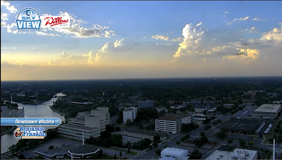
Yesterday evening's Wichita sky. KSNW TV. From the Alaska Air inflight magazine .

The Role of Faith-Based Groups in Hurricane Recovery

Please take a look at this . I believe you'll be pleasantly surprised.

Blog Note

I have had to temporarily restrict comments to blog followers only because of the barrage of spam comments that have made it through the normal filters recently. When I think it is "safe" again, I will make the comments less restrictive.,

Well Worth Your Time!

Image
A review of the Cassini's mission highlights. It is here .

Completely Off-Topic

Image
At left, Bob Gaudio. Top is Nick Massi. Bottom Center is Frankie Valli and at right is Tommy DeVito After all of the hurricanes, etc., how about something that is completely off the topic? On this day in 1962, Frankie Valli and the Four Seasons released their chart debut 'Sherry'. In four weeks the single climbed to the top of the Hot 100, making an impressive leap from #11 to #1, where it spent five weeks at the top. On writing the song, Bob Gaudio said: "Sherry took fifteen minutes. I was ready to leave a rehearsal we were having, and I sat at the piano and it just came out. Not having a tape recorder in those days, the only way I could remember it was to put a quick lyric to it and remember the melody and the words together. I had no intention of keeping the lyrics. To my surprise, everybody liked them so we didn't change a thing!"  Frankie Valli and the Four Seasons are my favorite group.

Is Global Warming Causing Some of Our Plant-Based Food to Become Less Nutritious?

Image
Actually, it is not global warming, the hypothesis is the higher concentration of carbon dioxide in the atmosphere is causing the plants we eat to have to much sugar and a decrease in other nutritious. The article is here . I recommend it.

Where Did Florida Residents Get Their Weather Information During Hurricane Irma?

The answer is, " local television news ."

Why We Need To Improve the Quality of Future Hurricane Forecasts

A well-researched and insightful article by my friend Ian Livingston .

Thank You "Los Angeles Times"...

...for a story thanking meteorologists for the low hurricane death tolls . At last, some much overdue recognition for our field.

Replay of "Jim Bohannon Show"

If you would like to hear a replay of my appearance on the Jim Bohannon  show, click here . Go to the 9-11-2017 show and my appearance begins about 11 minutes in. I want to thank Jim and his staff. I really enjoyed the hour.

Hurricanes Are NOT Getting Worse: These Articles Are Unfortunate

Image
Whether it is Leonard Pitts or New Republic , the misinformation about global warming and its connection, if any, to U.S. hurricanes gotten really silly. Because the genuine science doesn't support the contention, their argument is reduced to this: "And the timing of them, combined with the historic awfulness of them, feels more sinister than simple coincidence, does it not?" " Feels more sinister"? -- The arguments for catastrophic global warming have jumped the shark. Fact: Until August 25, 2017, when Harvey came ashore, the United States (including Hawaii) went a record 11 years and 10 months without a major hurricane . The period of record is from 1850 to the present. The former record was from 1900 to 1906, so we nearly doubled the previous record -- very good news.  Fact: Worldwide, there is no upward trend in hurricanes . See the data for yourself (below). Both graphs courtesy Dr. Roger Pielke, Jr., click to enlarge Fact: Worldwide, natur...