Posts

Showing posts from April, 2011

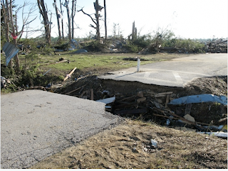
How to Help the Victims

I'm partial to The Salvation Army and Catholic Charities based on their past work and low overhead (almost everything gets to the intended recipients) but all of these are worthy charities: The Red Cross  has two shelters set up in Tuscaloosa, temporary homes to 240 people so far. The relief organization provided meals for more than  600 people on Friday  and is requesting more financial support. Donate to the Red Cross online  RedCross.org , text REDCROSS to 90999 to donate $10, or call 1-800-REDCROSS (1-800-733-2767) to give money or schedule a blood donation. The Salvation Army  has spread out all over the South, helping with sustenance for tornado survivors in Georgia, Alabama, Mississippi and Tennessee. Donate on the Salvation Army’s website at salvationarmyusa.org . Text “GIVE” to 80888 to make a $10 donation, or you can call 1-800-SAL-ARMY (1-800-725-2769) and designate “April 2011 Tornado Outbreak”. Save the Children  is providing food, doctors and education for kids, an

The Other Disaster

Image
The tornadoes have crowded the major flooding off this blog, so lets catch up. In green are the various flood warnings out: With rivers still rising, we would have enough problems. Unfortunately, additional heavy rains are on the way in these areas. This is a forecast of 7.3 inches of additional rain in the areas where flooding is already occurring. This forecast is valid from 7pm this evening until 7pm Tuesday. Click to enlarge maps. The situation in the Lower Mississippi Valley drainage area is going to get worse before it gets better. The Wall Street Journal  has a superb article about flooding in this region today. If the link does not work because you do not have a subscription just Google "battling nature on the river" and you can legitimately read the article. The author of the article, John Barry, wrote a book about the 1937 flood that explains how that event not just transformed the region but changed America. I recommend it. UPDATE, 4PM Saturday THE FOL

Bill Hooke on Tornadoes

I've been fortunate to call Dr. Bill Hooke a friend for several decades. A genuine gentleman and scholar, I would like to direct you to an interesting perspective on the recent tornadoes from his blog. Just click here . Hat tip: Roger Pielke, Jr.

How Powerful Were These Tornadoes?

Image
From Fox News, Smithville, MS I'm always glad to try to answer questions from my readers but I wish to mention again that all of the surveys of damage and tornado paths are not  completed so it is very difficult to make definitive statements about this month's tornadoes versus, say, the Superoutbreak of 1974 (where the surveys obviously are  completed).  Again, I have been asked why is the death toll was so very high, now ranking with the 1974 "Superoutbreak." Here is an illustration: the Smithville, MS tornado (above) has been rated EF-5. This tornado was so strong it pulled up the pavement and tore out a culvert. This type of damage is extremely rare. Maybe one tornado in 1,000 reaches this destructive power. When you are dealing with tornadoes of this violence, there are very few places that offer adequate shelter (i.e., even a basement would be unsafe), thus the extremely high death toll. As far as I am able to determine (again with the caveat that the studie

Nothing Like Terrible Suffering to Bring the Climate Hucksters Out

Image
I was asked yesterday why I had not posted "Think Progress'" (a liberal, pro-global warming group) unscientific attempt to tie Wednesday's tragedy to 'global warming' on this blog. I replied that I was so disgusted by it that I didn't want to give them the publicity. This morning, I heard from Al Gore in the form of this ad in my email: Without reproducing the whole thing, there is the clear implication that global warming causes worse storms. So, while I'm at it, here is Think Progress' vile pitch: Aside from being in horrible taste, is there any substance to their contention that global warming caused these storms?  No. Scroll down three postings and you will find a graph I created (using data from the pro- global warming British Climate Research Unit or CRU) that compares global temperatures during the previous worst two tornado outbreaks in the South and the similar "Superoutbreak" of tornadoes in 1974 that affected the South a

A Super Supercell

Image
Since I am still getting questions, let me do another posting regarding this week's historic tornado outbreak. Supercells are the strongest form of thunderstorm. One of the supercells from Wednesday was truly extraordinary. Brian Tang, National Center for Atmospheric Research via Facebook Click to enlarge. This is the supercell thunderstorm that lasted more than eight hours and spawned the huge tornadoes that struck Tuscaloosa, Birmingham, and Rome, GA. Preliminary map of tornado tracks These are the tracks of the tornadoes in the South Wednesday and Wednesday night. I have pointed an arrow to the tornado track caused by the supercell above. The number, path length, and intensity of the tornadoes is extraordinary.  Here is a similar map of the "Superoutbreak" of April 3-4, 1974. While the number of tornadoes in 1974 was greater, the path length appears more or less similar. There is some concern about how this survey has been conducted. Click here if tha

Storm Chasers Killed?

I have waited to post this but now several sources, including this one , are reporting that a car filled with teenagers and video equipment was found in Tuscaloosa. The occupants died and it is believed they were storm chasing. I have also had the video below (from YouTube) for nearly two weeks of amateurs driving into a tornado. From the audio, they seem to be chasing the storm. At the :36 mark, you can hear what sounds like an adult voice say, "let's go!" in the background as they accelerate into the storm. The video was taken at Dunn, NC Saturday, April 16, 2011. I haven't posted it until now because I was afraid it might inadvertently encourage people to engage in this behavior. As far as I'm concerned, driving into the immediate vicinity of a tornado (whether penetrating the tornado was intentional or not) is recklessness in the extreme. This blog, on numerous occasions, has warned of the extreme danger of storm chasing unless you are thoroughly trained

Upcoming the Next Seven Days

Image
Sierra just before the interview started. One our favorite programs at The Smith House is "It's All Good" with Sierra Scott . It is a half hour program on the Kansas CW (KSCW TV) in prime time, 7:30pm Sundays, that focuses on good news stories. Very pleased to report that I'm going to be featured on the show Sunday evening. For those in Kansas and northern Oklahoma, I hope you can tune in. I'm also doing a book signing and Q&A about severe storms a week from tonight (May 6) at the Barnes & Noble in Bradley Fair, 21st and Rock Rd., in Wichita. It will start at 7pm. Warnings,  which is written like a mystery novel, takes the reader inside the world of severe storm warnings. It is a fast-paced read that will give you a new insight on what meteorologists have been dealing with the past month. The knowledge it conveys about the warning system might just save your life.

Leave it to the NY Times to Write an Inaccurate and Insensitive Article

Image
I had planned on moving on to other topics today. There is little more to say about the tornadoes of the last three weeks until the investigations are completed. As I was going through my email this morning, a reader sent me a link to this article in The New York Times :   Predicting Tornadoes: It’s Still Guessing Game I thought my book Warnings  pretty well makes the case that we have become highly skilled at forecasting tornadoes. With regard to the recent tornadoes this article and, especially, this article  convincingly make the case that these tornadoes were very well forecast. The Times' article begins with this statement: The cruelty of this particular April, in the number of tornadoes recorded, is without equal in the United States. This may or may not be true. The statement is at least premature. The NWS Storm Prediction Center March 8th changed its methodology which allows more reports  of tornadoes and other severe storms to be logged (see first note here ). W

Two Day Tornado Summary

Image
Yesterday, Red dots = tornado report. Blue = damaging wind. Green = large hail. Black triangle is very large hail. Today, I'm pleased to report that the tornado-producing system has moved out into the Atlantic.  This nightmare is over.

Brown Gashes on an Otherwise Green Earth

Image
You'll want to click to enlarge this image. This from the AQUA earth-monitoring satellite. These tornadoes were so large they left visible brown gashes on the Alabama countryside. To help you find the gashes, storm chaser Aaron Kennedy  put yellow lines parallel to the tornado's tracks. I have added the arrows.  The city of Tuscaloosa is between the "a" and my first arrow. The path across Birmingham was largely covered by clouds when the satellite passed over. ADDITION: Excellent photo coverage from The Boston Globe .

The Question of the Day

Image
Posted on this blog early Monday morning. I predicted more than 100 tornadoes would occur. I'm changing planes at O'Hare at the moment and just saw that the death toll is up to 250 per The Wall Street Journal and 272 per CNN. It is difficult to write this due to the shock that so many were killed when the forecasts and warnings were so good. That dichotomy is the question of the day. I have already given two interviews to reporters wanting me to comment on why so many people were killed. I wish I didn't have to answer the question, it seems premature when people are still digging out of the wreckage. We'll know  the answer in a few months after meteorologists and social scientists do their post-storm assessments. That said, people want answers and understandably so. Tornado season is only halfway done and we don't want to lose any more precious lives if we can avoid it. Both reporters were already familiar that the forecasts and warnings of yesterday's st

Tornado Watches Still Out

Image
3:30pm EDT:

Lightning + Ocean + Sunset = Beautiful Photo

To enjoy, click here .

10:10am EDT Update

Image
Watches now in effect. Blue = severe thunderstorm. Red = tornado. Currently, AccuWeather region radar shows three lines of thunderstorms. There is only one tornado warning in effect, just north of Richmond.

CNN Reports 173 Dead

Image
This is staggering. While it is too soon to be sure, based on the meteorological parameters, I think we are going to find that this is the largest number of "path miles" of F-3, F-4, and F-5 tornadoes since the "Superoutbreak" of April 3-4, 1974. I base that on the fact that the "significant tornado index," which is designed to indicate when tornadoes of F-2 or greater intensity will occur, had the highest numbers I have ever seen yesterday. For comparison, during the recent North Carolina outbreak, the index was running around six. The Good Friday St. Louis today was also around 6.  Much of yesterday in Mississippi and Alabama the index was running around 12-14. Here is a map that shows the geographic extent of the outbreak, and, here is a map showing the concentration of tornadoes in the South: I'll have more on this as we learn more through the day today.

Watches Still in Effect

Image

Wall Street Journal Reports 72 Dead

Final Live-Blog Report of the Night

Image
Above map is the tornado warnings in effect at 11:56pm Eastern (red). Maroon = flash flood warnings. Amber = severe thunderstorm warnings. Green = various flood warnings. The immediate tornado threat for Atlanta (i.e., until 1am Eastern) has lessened as those cells have weakened. However, there is a chance the thunderstorms in east central Alabama could strengthen and move into Atlanta later in the night. This is my last live-blog report of the night. Hope they have been helpful.  Go to accuweather.com for continuing coverage throughout the night.

Video of the Birmingham Tornado

Image
The above is a frame capture from the video available here .

Tuscaloosa Tornado Video

Image
The University of Alabama campus sustained damage from this tornado. Live coverage of the tornado as it occurred here .  The young meteorologist did a great job under the circumstances.

Atlanta Update

Image
The purple polygon is a tornado warning southwest of Atlanta. The tornado indication is near Newman, GA at 11:21pm EDT. I have circled downtown Atlanta and put a rectangle at the approximately location of the Atlanta Airport.

Huntsville Area Update

Huntsville area has taken a hit with a report of severe damage at Dadesville, GA. There is a report that power has been lost at the Browns Ferry Nuclear Power Plant.  Phone servie is out in northern Georgia.

Horrible Death Toll

The Associated Press is reporting that 64 have been killed by today's storms. In Alabama, 450,000 homes and businesses are without power -- a huge number.

Tornadoes North and South of Atlanta Metro

Image
There are tornado warnings north and south of the Atlanta Metro area with the positions of the likely tornadoes indicated by arrows. However, Atlanta should not let its guard down.  There are other strong thunderstorms upstream in Alabama that could still possibly produce a tornado in Atlanta later in the night.

Carolinas and Virginia Update

Image
Here are the tornado warnings (red) and flash flood warnings (maroon) as of 10:21pm EDT: AccuWeather regional radar shows intense supercells quite capable of producing tornadoes: While there are tornado warnings out on a number of storms, the arrows indicate the three most likely to produce major tornadoes.

Threat Shifting East

Image
The wide view of AccuWeather radar shows the supercell that produced the devastating tornadoes in Tuscaloosa and Birmingham is till going strong (arrow) and a tornado warning is still in effect along its path. There is a tornado warning in effect (purple polygon) with a hook echo on this thunderstorm northwest of Atlanta (lower right in image): Strong thunderstorms are southwest of Atlanta and residents should keep a close eye on them as they approach.

Middle Atlantic Tornado Threat

Image
Virginia continues under a tornado watch and tornado warnings are in effect for each of the cells I have highlighted. They are moving northeast

Now Video Blogging at AccuWeather.Com

Image
Here is a link . The threat is rapidly shifting into northwest Georgia (tornadic thunderstorm west of Roswell), western North Carolina and far northeast Tennessee. A report r ecapping the outbreak to 9pm EDT.

Tornado Warnings from Virginia to Mississippi

Image
At 9:06pm EDT. Red = tornado warning.  Maroon = flash flood warning. There is a tornado warning near between Richmond and D.C. then then numerous warnings from western Virginia to southwest Alabama. The threat is starting to shift into Georgia where a "particularly dangerous situation tornado watch" is in effect. Note: I'm doing special video reports on AccuWeather.com

Large Tornado Moving into Shelby, Co., Ala. at 6:59pm

National Weather Service's Birmingham office has taken shelter. Warning responsibility being handled by NWS Mobile.

HISTORIC TORNADO OUTBREAK - PDS Tornado Watch for Atlanta and Greenville-Spartanburg

Image
CURRENT TORNADO WATCHES IN EFFECT AS OF 6:49PM CDT The geographic extent of the tornado watches in effect for this tornado outbreak will rival the "Superoutbreak" of April 3-4, 1974. There is a new PDS tornado watch until 2am EDT for Atlanta and Greenville-Spartanburg. This is rapidly transitioning to an "after dark" tornado outbreak which -- statistically -- triples the likelihood of fatalities. Keep up on the weather as thunderstorms approach in any of the tornado watches.  Here are the reports of tornadoes from 7am CDT to 7pm CDT: and...

Wide View of Tornado Threat

Image
Tornado warning just southeast of Washington, D.C. (upper right corner of image). Other tornado warnings in south central Virginia. There is a second developing tornado threatening Jefferson Co. and Birmingham.  Most all of the large, isolated supercells in eastern Tennessee, Alabama and eastern Mississippi have tornado warnings on them. The tornado index in MS-AL are the highest  values since the index was created.

Tornado in North Birmhingham

Image
Confirmed: Large tornado through the west and north part of the Birmingham area...the threat continues northeast of Birmingham The tornado has "leveled homes" in Hueytown and passed very near Little Italy and Driftacks. It is now near Hooper City moving northeast. The debris ball is circled at left with the maxed out Doppler winds (circled at right). This is a major tornado.  Time: 6:04pm

Tornado Moving into Birmingham

Image
5:41pm radar. Debris ball circled and downtown Birmingham circled. I've added an arrow showing the movement of the tornado. A debris ball = debris lofted into the air by the tornado.

Debris Ball Southwest of Birmingham

Image
UPDATE 5:33PM Central Time. Tornado warning for Jefferson Co. and Birmingham.  Debris ball is getting ready to move into SW Jefferson Co. It is moving toward North Johns, Bessemer, and into the Birmingham Metro Area if it continues on the ground. UPDATE:  5:32PM Central time: I'm shocked there is no warning of any kind for Jefferson Co., Alabama. This tornado is getting uncomfortably close the southwest part of Jeff Co. and I suggest being prepared to take cover. The debris ball at this time is about 2 mi. SE of Burchfield. I'll post a new image momentarily. Click to enlarge A pronounced "debris ball" -- a signature of a tornado on the ground -- is southwest of Birminham (between Hold and Cottondale) and moving northeast. This is a terribly dangerous situation! The debris ball is caused by the tornado lofting debris into the air where it reflects high amounts of the radar's energy.

In the Words of the NWS Storm Prediction Center...

Image
"An extremely dangerous, life-threatening situation continues to unfold this afternoon across a large part of MS and AL...with adjacent portions of TN and NW GA also expected to become a concern late this afternoon and evening." The Birmingham radar is downright ominous at the moment (4:42pm CDT) with two hook echos, one southwest of Birmingham: click to enlarge Hooks (tornado signatures) are circled, arrows indicate the previous paths of the hooks indicating perhaps long-track tornadoes. Tornado warnings are in effect for these areas!

This is Getting Scary

Image
Tornado warnings out on numerous thunderstorms in the South. The hook echoes at 2:51pm Central are indicated with arrows, the circled thunderstorm between Birmingham and Huntsville (circled) is looking increasingly suspicious. Tornado watches now out for the East Coast states. This truly is a "particularly dangerous situation."

PDS Tornado Watch - Alabama

Image

Here We Go Again - PDS Tornado Watch for Mississippi

Image
If you didn't know what a PDS tornado watch ("particularly dangerous situation") was before the 2011 tornado season, unfortunately you do now.  A PDS has just been issued in Mississippi. This a truly a dangerous situation. If you are in northeast Louisiana or in Mississippi, please keep up on the weather this afternoon and evening!