Posts

Showing posts from March, 2022

Look For Less Accurate Weather Forecasts In the Near Future

Image
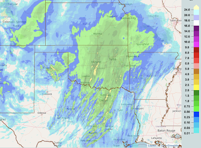
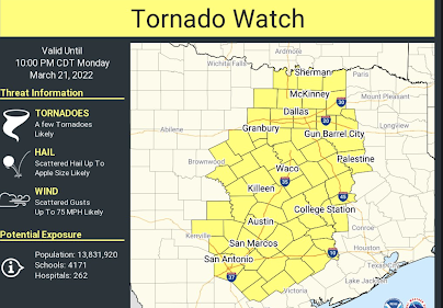
The National Weather Service (NWS) launches weather balloons twice a day (more often when extreme weather is forecasted to occur) to gather information on the pressure, winds, temperature and humidity aloft. This data is absolutely vital, especially during tornado season, to the accuracy of storm forecasts and warnings. The NWS officially announced this morning that we will be losing about 10% of our rawinsondes during tornado season -- when they are needed the most -- because of contract and other issues.  The preservation and improvement of the meteorological database is the National Weather Service's Job One because, without that data, neither it nor anyone else can make accurate weather forecasts and, when it comes to tornadoes, accurate warnings.  I'm not the only meteorologist with that opinion. The NWS's own Roger Edwards of their severe storm prediction center says, A "RAOB" is meteorologists' shorthand for the data radioed back by the weather balloon

Slow-Motion Snow Falling

A mesmerizing video of snow falling in slow-motion in Wichita. Enjoy!

Why Electric Cars are Terrible for the Environment

Image
And... much of this is done by child or slave labor.  And... the grid is already strained by existing load.  And... China controls much of the supply of these metals.   The idea electric cars are good for the environment is magical thinking at its worst. 

Another High Risk For Tornadoes Day

Image
The hatched area is where strong tornadoes are forecast to occur. The red area has a high risk of tornadoes.  The yellow area has an enhanced risk of tornadoes. The brown area has a significant risk of tornadoes.  Damaging tornadoes have already occurred today. Please monitor local sources of weather warnings in these areas. 

This Evening's Tornado Risk Extended North

Image
NWS's Storm Prediction Center has expanded the significant tornado risk area into Kansas and Missouri.  The higher risk of tornadoes is after dark. Please take your smartphone with WEA activated to bed with you if you live in these areas. 

Fire and Tornado Forecast

Image
Fire Danger Let's begin with the fire situation as there is a rare "extremely critical" (purple) forecast for the High Plains.  It is vital that fires not start. Do not try to burn anything in the red and, especially, purple areas. Tornado Risk Later Today and Wednesday We have a significant (brown) tornado risk in parts of Oklahoma and Texas. There is a high  risk of tornadoes in the South tomorrow and tomorrow night. In the hatched area, strong tornadoes are likely. 

Update on the Status of the 2022 Winter Wheat Crop

Image
The short answer: not good. Here is a map of the primary hard red winter wheat area in the United States. Darker green represents more wheat production.  Here are the current conditions of the wheat crop. The drought has really cut into wheat crop conditions in OK-TX-CO. Here is the forecasted precipitation (rain and melted down snow) for the next two days, until noon Wednesday. I have superimposed a rough outline of the primary wheat growing area. Because of the dryness and high winds, extreme fire danger is likely over much of the region. Beyond Wednesday, here is the forecast rainfall from 7am Wednesday to 7am Monday.  We need a slow inch or two across the entire winter wheat area and that is not what is likely to occur.  Given the issues with Russia and the Ukraine, these problems in the USA will lead to bread shortages in parts of the world. Here, I think we'll have enough supply but at significantly prices. 

When Does Tornado Season Begin in Your Area?

Image
It is the time of year when you can expect to experience tornadoes in your region. Of course, they vary greatly by year. 

Interested in All Things Weather?

Image
If you enjoy this blog, Mike Smith Enterprises has a variety of ways we serve people who have interests in weather.  Photography You can see my photos at Adobe Stock Photography, here . Whether advertising or editorial, we have photos that will suit your needs.  Books Warnings tells the story of how meteorologists like Dr. Ted Fujita and other brilliant, courageous scientists eliminated downburst airliner crashes, cut the tornado death rate by 95%, and other amazing accomplishments. It is an uplifting story that reads like a novel. From a new review at Amazon:  The book is easily readable and very informative. It is a keeper for my library. Great job. When the Sirens Were Silent   is the true story of the Joplin Tornado -- one of the worst in history. It also includes vital safety information for you and your family. Tornado Season 2022 is just underway as we saw last week. More tornadoes are quite likely this week. Please take the tornado safety advice to heart. Live Presentations

Sunday Fun? While Hell is No Laughing Matter....

....it is when The Babylon Bee  tells us about nine of the most brutal punishments .  You don't want to go to Hell, so go to church today!

The Looming Food Shortages

Image
We've been warning you for several months. Update 5:5p Sunday As I'm sure you realize: less fertilizer = less food.

Could This Have Anything To Do With the Fact Physics Has Made No Progress in Nearly 50 Years?

Image
Whether it is The Big Bang Theory  or in magazines about physics theory, many have been discussing the lack of progress in basic physics theory since the 1970's.  It is a topic that has puzzled me until this journal paper was brought to my attention: "Whiteness." Sigh. 

Lightning Kills Cattle For the Millionth Time Since Creation -- This Time It Must Be Due to Global Warming

Image
Beyond absurd.... What does it have to do with climate change?   Nothing! You'll see a lot of gross pictures if you Bing " cattle killed by lightning ," so I'm not showing any of those.  Many head can be killed by a single bolt because cattle often take shelter under trees or near metal fences.  And............ The reason meteorologist Matthew Cappucci didn't mention the Texas tornadoes is because they had nothing to do with global warming. They were typical Texas tornadoes occurring at the time of year they typically occur. Also, for the millionth time, violent tornadoes are getting less  frequent as earth temperatures have warmed. This is a chart of official NOAA figures.  There are many good reasons to decarbonize energy via nuclear energy and by hydroelectric sources (and not windmills and solar). The earth has clearly warmed the last 60 years and man is part of the reason. But, repeating these scientific absurdities do no one any good. 

50th Anniversary of "Tornado Chasing"

Image
March, 2022, is the 50th Anniversary of Tornado Chasing   OU's Felgar Hall where the meteorology department was located While an amateur meteorologist named Dave Hoadley had storm chased since the 1950's, the scientific storm chasing program began in March, 1972. While I don't remember the date, the meeting of the University of Oklahoma Student Chapter of the American Meteorological Society that month featured speakers Dr.s Joe Golden (NSSL) and Bruce Morgan (Notre Dame). They proposed that students chase tornadoes -- for science.  One of NSSL's two original Doppler radars, 1972 Certainly it wasn't for money! The National Severe Storms Laboratory wanted us to chase all over Oklahoma so as to determine the value of its Doppler radars but they didn't even give us gas money. We were needed to confirm ("ground truth") what the Dopplers were seeing. It was our work that would determine whether Doppler -- far more expensive than traditional weather radar --

Attention: Young Meteorologists and Storm Chasers

Image
This piece is intended for young meteorologists and storm chasers.  Which Radar Would You Rather Have Used? I constantly, especially from people in North Carolina, receive criticism of the Terminal Doppler Weather Radars. This criticism is misplaced as tonight's east New Orleans Tornado demonstrated again.  Here is map of the tornado's path across metro New Orleans.  Matthew Cappucci/MyWeather/CWG It appears the New Orleans NWS did a fine job with the warning.  This was the NWS WSR-88D at 7:24pm when the tornado was moving through Arabi and the Lower Ninth Ward. Click to enlarge the images.  Here is the Terminal Doppler Weather Radar at the same time.  The tornado on the -88D, while visible in the velocity data, is not nearly as obvious as it is on the TDWR. It is not just the velocity data (right) but look at the more obvious hook in the reflectivity data. Assuming no attenuation, if I only had one radar to use, and they were equidistant from the tornado, I'd always pick t

Tornado High Risk Moved North

Image
The highest risk area (red) for strong tornadoes has been moved north a bit and the significant tornado risk (brown) has now been extended into far southwest Tennessee. This forecast is from the NWS SPC. This is one of those conditional risk situations: if  supercells develop, there is a high risk they will produce tornadoes that will likely be strong and long-tracked.  Please monitor local weather information in this area! I will supplement it with coverage on Twitter @usweatherexpert. 

Updated Tornado Risk Outlook

Image
Here is the updated tornado risk forecast. See color code below. 

High Risk Tornado Day in the South

Image
Another major tornado day Tuesday and Tuesday evening. Forecast valid 7a today to 7a Wednesday. Red = high risk of strong tornadoes. Yellow = enhanced risk of strong tornadoes.  Brown = significant risk of tornadoes.  Please keep up on the weather throughout the day.  Note: there is the potential for large hail, damaging winds and a couple of tornadoes in the cloud-shaped area below until 6am CDT. See map below.

Precipitation to 9pm CDT

Image
Badly needed rains have fallen today over the winter wheat belt. 

Overnight Tornado Watch

Image
Tornado watch until 3am. 

7:30pm Tornado Outbreak in Progress

Image
Numerous damaging tornadoes have occurred in Texas today with one in southern Oklahoma. They are still occurring. A new tornado watch will be issued for east Texas shortly.  Here are rotation tracks to 7pm. Whites and blues = likely tornado on the ground. North Texas. Central Texas

Tornado Watch: Central Texas Till 10p

Image
First Tornado Watch of the Day This is the time to call your family and friends to make sure they are monitoring the weather  and  that they are ready to take shelter if a tornado warning is issued.  If you live in a mobile home, it is time to go to a friend or family member's home. Mobile homes are not safe! You can follow me on Twitter @usweatherexpert   for updated forecast and warning information.  Note: I don't post every watch on the blog. Please follow me on twitter for more information.