Posts

Showing posts from August, 2017

What It Was Like to Experience the Eye of Hurricane Harvey

Image
We've talked a lot about the flooding. Here is the rest of the story. Imagine if these winds had struck a major city. The best video of what it was like to be in the path of the eye of Hurricane Harvey as it tore apart Rockport, Texas. I recommend it highly including the fact you can hear the roar of the hurricane's winds.

Let's Cool It a Bit

Yes, there are other potential hurricanes (as there are always potential  hurricanes this time of year) out there that could  affect the United States. However, all indicates are that, even if one takes a path that actually threats the USA it, it would be a week before it would be time to take precautions. So, this blog is taking a hurricane break after ten days of dealing with Harvey. We'll watch the potential storms and, after the Labor Day Weekend, I'll update everyone about hurricanes again.

Ain't It The Truth!

Image
Friday evening we broke the longest major hurricane drought (interval between major hurricanes) in 150 years. Harvey broke the drought after almost 12 years. The previous drought was six years (1900-1906). It is just amazing to me that people would blame Harvey on global warming while not noting the drought of major hurricanes in the United States.

For Our Readers in the Southwest

Image
A sobering story from the Los Angeles Times : It is a well-written story I recommend.

Extreme Gasoline Prices

Image
Via Twitter from KXAS-TV (@NBCDFW), this a gas station in Garland, Texas, this morning. This is an isolated situation but it is likely not price gouging. There is an extreme shortage in parts of Texas because of the shutdowns of refineries in the area. And, there is a huge bump in demand because, Relief providers have to get gas before they can make the 4 hour drive to the flooded area. All of the evacuees from the floodwaters who are in DFW have to fill up. The holiday weekend. Supply and demand -- the 76 station had to pay a much  higher wholesale price to get gasoline to sell to its customers.  This was anticipated this past Monday in  Dr. Kevin Simmon's editorial . It is my sense that this is going to get worse before it gets better. If you are traveling this weekend, it wouldn't hurt to fill your tank now. 

Things Are Not Getting Better

Image
The Texas flooding catastrophe is far from over.  In addition to Greater Houston, I have tried to focus on the continued threats to the Beaumont-Port Arthur-Orange area including posting a forecast for unprecedented flooding (scroll down) yesterday evening. Unfortunately, things are just getting worse. From KPRC TV Since the Neches River is still rising, the fresh water supply will not be back soon. Beaumont is a city of 118,000+, so providing water for drinking, washing, etc. is going to be quite a challenge. The Beaumont to Houston area is especially critical to the U.S. economy because of the concentration of oil refining and chemical processing. Added info: Here is an update to the hydrograph posted below. The Neches is rising even faster than forecast to a crest that is higher than forecast. Note how far above the record the river level is! click to enlarge Here in Wichita, as of yesterday afternoon, gas was up 40¢ since Saturday. Via Twitter, the image below i...

Extreme Record Flooding Expected In Beaumont, Texas

Image
People throughout the Beaumont area should be reacting to this forecast.

Serious Inland Flash Flood Risk

Image
Here is the additional rainfall expected from the remains of Harvey. In addition to the 10+" in Tennessee, note also the 9.2" over the next five days in South Carolina. There is a high risk of flash flooding tonight in the South. And, a high risk of flash flooding in western Tennessee and southeast Kentucky. I urge you to "Turn Around, Don't Drown." In fact, if torrential rain is occurring at night, don't venue out at all unless it is an emergency.

Congratulations Ali, Phil and Becky!!

Image
We just had our AccuWeather celebration for our team that won a major American Meteorological Society Award . If you would like to learn about AccuWeather's critical work during Harvey and at other times just scroll down or click here .

Tornado Watch For Mississippi and Louisiana Till 6pm

Image
Please note there is a "moderate" risk of tornadoes of EF-2 or 3 intensity. Please monitor the weather if you are in the tornado watch area.

Want to Know What It Was Like to Be on the Ground in Houston?

Eric Berger is a great writer from Houston and an amateur meteorologist. His story is here .

7:30am Update: T.S. Harvey

Image
AccuWeather is estimating the storm's total damage will approach $160 billion which would be nearly the cost of Sandy and Katrina  combined.  Our team points out that is 0.8% of the U.S. economy.  Details at the link. Harvey is a tropical storm near Lake Charles, LA. Radar is from 7:29am with the arrow pointing to the center of the storm, now moving northeast. Greens are flash flood warnings. While the rain has cleared The Woodlands - Houston - Galveston, torrential rains have occurred during the night in the Beaumont-Port Arthur-Orange area where much of the USA's oil and chemical plants are located. Even when the floodwaters go down, highways and rail tracks are going to have to be inspected and, in some cases, rebuilt. AccuWeather has more details . The human toll is nearly inconceivable. This morning's Wall Street Journal  (paywall removed) has that aspect of the story. Over the next three days, the storm is going to finally move northeast and weaken. ...

6:03am Tuesday Rain Has Ended in Houston

Image
The rain has ended in Houston, The Woodlands and will end in a couple of hours in Galveston. Some spots of blue sky are visible at Bush-Intercontinental Airport! Unfortunately, torrential rains are still falling in the Beaumont-Port Arthur-Orange area where so many oil refineries and chemical plants are located.

A Terrific Article About AccuWeather in Today's "The Street"

Image
BNSF train stopped by an AccuWeather tornado warning in west Texas The article is here . I t reflects our corporate mission to protect people, property and profits. The bottom line: If your enterprise is not working with AccuWeather Enterprise Solutions , you are likely making a strategic miscalculation that could eventually cost a great deal of money and might put your business at risk. An excerpt: When Starbucks Corporation  ( SBUX ) wants to  gauge how many iced or hot  drinks  it may sell in a given season, it turns to AccuWeather's predictive analytics team. AccuWeather can advise the coffee chain if, say, October will be colder than usual, meaning more hot Pumpkin Spice Lattes than chilled brews will fly out the door. And when Class I railroads, including Norfolk Southern Corp ( NSC ) ,Union Pacific Corp ( UNP ) and CSX Corp. ( CSX ), need to know if tornadoes could derail their trains, they turn to AccuWeather, too, just as other clients, such...

A Sad Tale: What Happens When You Don't Heed The (Excellent) Warnings

Image
I have verified this is a bona fide Twitter account. It will break your heart even though the first of these tweets is -- to meteorologists -- extremely frustrating. I am leaving off the name. They are posted in chronological order. Friday: Oh---kay. When she could have been evacuating, with just hours until the flood, this tweet was posted. As far as I can tell, it was her only tweet Saturday. There was still time to evacuate. Things go downhill very, very quickly Sunday morning: Then, calamity ensues:  She wraps things up with. If this woman heeded the storm warnings, she would be someplace warm with her most important possessions and her loved ones. Tragic. I do empathize with her in one way. A non-meteorologist news reporter she quoted wrote, "I'd be skeptical of the maps calling for extreme rainfall." I do not try to do brain surgery. Why can't others leave weather forecasting to meteorologists!? As I wrote previously ,...

Oh, Good Grief!

Image
From the usual suspect, Climate Central. It has been picked up by a number of people today because it is supposedly Houston Hobby. Hint: Delta does not fly to Hobby. WattsUpWithThat has the details. This is no time to be worried about global warming or politics. Let's make donations and focus on what we can do for the victims and for the future of disaster management in the United States. There will be plenty of time in the future for politics and side issues.

Editorial: The Incredible Cost of Harvey

Image
From my friend, Dr. Kevin Simmons in the Dallas Morning News : The entire commentary is well worth reading, but here are some highlights. Hazard Hub collects exposure data on all structures in the U.S. By mapping the flooded areas and estimating the value of properties impacted by the flood, they find $145 billion in property value at direct risk within the 500-year flood plain. Rainfall from this storm is so severe, that a reference point of 500 years may not accurately capture the full nature of the disaster. To put this in perspective, in 2005, Katrina is estimated to have cost about $100 billion with $40 billion covered by private insurance and $16 billion covered by the National Flood Insurance Program. Most mortgages contain provisions that homes located in vulnerable areas carry flood insurance. But this storm is so large that it extends into parts of south Texas not normally considered at imminent risk of flood. Families who did not believe they faced potential for floo...

Additional Rainfall Forecast: Makes Me Want to Cry

Image
Here is the latest NWS forecast of additional  rainfall between now and 7pm Wednesday.

Wow...Wow...Wow

As Instapundit says, faster please! A major medical breakthrough .

Mayor and Governor Arguing: Evacuate or Stay?

More Evidence as to Why the U.S.A. Needs a National Disaster Review Board From this morning's Wall Street Journal online : HOUSTON—A split between Texas Gov. Greg Abbott and Houston Mayor Sylvester Turner over whether the metropolis should have been evacuated is raising questions about officials’ response to damaging floodwaters as a catastrophe continues to engulf the region. Mr. Turner, a Democrat, and other local officials urged residents to stay in their homes as Hurricane Harvey, which has since downgraded to a tropical storm, approached Houston on Friday. But at a Friday news conference, Gov. Abbott, a Republican, suggested otherwise. “Even if an evacuation order hasn’t been issued by your local official, if you’re in an area between Corpus Christi and Houston, you need to strongly consider evacuating.” While I believe both officials were trying to do the right thing, we don't know what the "right thing" was. Our knowledge of how to handle a dis...

Images of a Disaster

Image
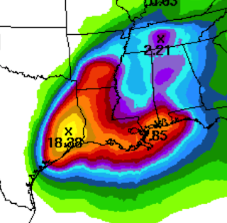
Here is the amount of rain that has fallen on southeast Texas, including Houston and Beaumont, over the last five days. click to enlarge And, here is the forecast for additional  rainfalls the next five days. Yes, that is a forecast for another 20" inches of rain -- bringing the storm total to nearly 50 inches -- from south Houston along the northern edge of the Ship Channel. Serious flooding is likely going to extend into western and southern Louisiana with an additional 10+ inches of rain in addition to the 5-10 inches that has already fallen around Lake Charles. Note also the risk of flooding rains (nearly 5 inches) extends into Arkansas. Yes, the center of what is left of Harvey is moving back over the Gulf. However, Harvey does not have an eye and it is unlikely that significant  strengthening will occur. However,  with gusts to 45 mph and completely saturated soils, the risk of power failures may increase due to toppling trees where the higher gusts oc...

Editorial: Renewing My Call For a National Disaster Review Board

Image
What happens when the ability of weather science to forecast a catastrophe outstrips the ability of emergency management to respond to the forecast? There is an unprecedented catastrophe in progress in Texas . Before anyone could fully respond to the wind damage caused by Category 4 Hurricane Harvey, what will be the worst flooding in the history of the state was already underway. During the past decade, weather science has made amazing progress  in forecasting extreme weather. Harvey’s one-two punch was fully forecast by AccuWeather, the National Weather Service and others days in advance. And, it wasn’t just Harvey’s winds and position that were well forecast.“Catastrophic” (the word used by many forecasters) flooding was forecast, as well. At 9:10am Thursday, when Harvey was still a tropical storm, this blog told people living in a 100-year flood plain to prepare to evacuate. At 8:10am Friday, the following advice was posted: Suggestion to people in 250-year flo...

A National Catastrophe is Underway in Houston and Southeast Texas

Image
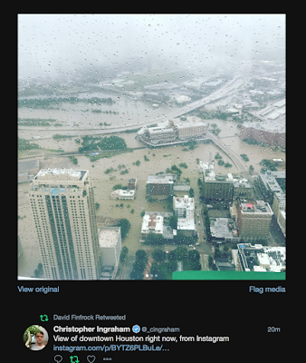
Via Instagram at 11:08am, Downtown Houston It is difficult to overstate the impact on the United States the catastrophe in southeast Texas  will have.  More than 20 inches have fallen on the Houston Metro area with more than a foot of rain in Beaumont-Port Arthur as of 10am Sunday Torrential rains continue to fall as of 10:45am Sunday It took people two days to realize the extent of what occurred in New Orleans because of Katrina. I believe the same is true for what is now occurring in southeast Texas.  Not only did Hurricane Harvey's winds nearly destroy several small towns in its path, its flooding rains are going to be news for weeks and it will have an effect on the U.S. economy. For example, here is a list of airports that are closed: The three-letter codes translate to: Corpus Christi Spring, Texas Ellington, Texas (general aviation airport) Grants Houston - Hobby Houston Bush Intercontinental  Aransas Pass (Mustang Beach) San An...

How To Take Shelter When a Tornado Threatens During a Flood

What should you do if you are in a flooded area when a tornado warning is issued? My suggestion is to get on the lowest safe  (from flooding) floor. Of course, this may be the second floor. Stay away from windows and put as many walls as possible between you and the tornado or  get in a bathtub. Take your smartphone (with a weather app), your weather radio or other source of weather information into shelter with you.

The Rain Continues to Fall on Southeast Texas

Image
Here is the latest AccuWeather mosaic showing heavy rain still falling on southeast Texas. White symbols are lightning bolts. The radar is from 8:45am. Sunday, Please see below for more information.