Thursday, October 31, 2013

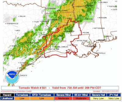
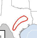
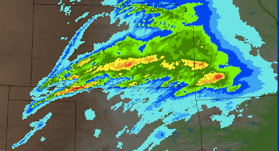
Tornado Warning Along Mississippi River

Two tornado warnings with radar at 7:22pm.


ORIGINAL POSTING:

Tornado Warning in effect for Cape Girardeau Co., MO and Alexander Co., IL. At 7:17, the most likely location of the tornado was in the immediate City of Cape Girardeau area.
Severe thunderstorm warnings for damaging winds in the yellow polygons.

Take cover immediately.

Trick or treaters east of this line of storm should head for cover!!

I am not live-blogging these storms.


Turn Around, Don't Drown

KWCH TV reports the children are safe. They just reported this was a low water crossing bridge not a regular bridge. A viewer took a photo showing rapidly flowing water over the crossing less than a half-hour before the accident, which I have viewed.

From KWCH, here is an aerial shot of the bus on its side in rapidly flowing water. You can see the emergency exit door opened.


I'm posting this because it goes back to our advice Turn Around, Don't Drown. The area had more than 3 inches of rain in the last 48 hours (see below). The driver did not "turn around."

Please watch this very brief video of a driver who is perfectly safe, drives into what looks like shallow water, and nearly dies. 
Chris says had his car not buckled and the window broken he never would have been able to get out. 

This map is the 72-hr. rainfall with an arrow pointing to the bus accident location.
click to enlarge
The bus driver who may have broken his back and was submerged in water for a considerable time just landed after being airlifted to Wichita's Wesley Medical Center.

There are other areas where this could occur tonight with the torrential rains in Texas last night (24-hr. map). Lots of low water crossings.
If you encounter water across the road tonight or any other time: Turn Around, Don't Drown!

Tornado Watch Lower Ohio Valley

This tornado watch is in effect until 1 am CDT. There is also a moderate possibility of wind gusts up to 80 mph. Please keep this in mind with trick-or-treating this evening. 

How to Work With a Professional Speaker

An article I wrote for our Rotary district newsletter. See page seven.

Tornado Watch Mississippi, Louisiana and New Orleans

In addition to this tornado watch, the Storm Prediction Center also has increased the tornado probabilities in the Mid-Mississippi Valley. See below:
Keep up on the weather in these areas this afternoon.

National Weather Festival This Saturday


Mindy and I are really looking forward to the National Weather Festival in Norman, Oklahoma, Saturday. Full details, including directions, are here.

I will be speaking at 10:45am in room #1350 on The Tornado Warning System; Where Do We Go From Here. We'll also have copies of Warnings at a huge discount from the bookstore price and I'll be happy to autograph the book if you already have it or if you wish to purchase one Saturday.

Remember: Christmas is coming. This would be a great time to get the book for gift-giving.

See you Saturday!!

Happy Halloween

Swirling skies are putting the 'Witch' in Wichita this Halloween morning. 

Note how bright it was when I took this photo. The sun was in the east while the storm was moving in from the west. With the brightness, I thought I saw lightning a few minutes later but wasn't sure. About 5 seconds later, I was certain thanks to the amazing AccuWeather Enterprise Solutions' SkyGuard® Mobile.

Tornado and Severe Thunderstorm Threat

A tornado watch is in effect until 2pm.

There is a much larger area where thunderstorms (lightning hazard) with damaging winds are expected today and tonight.

Heavy Rain Has Fallen; More Rain Forecast

So far, at the Smith House, we have had 1.40 inches of rain with this line of thunderstorms about to move in.

There was extraordinarily heavy rain near and southwest of Austin overnight. Radar indicates as much as eight inches of rain fell. Water rescues are occurring as I write this.

More heavy rains expected over the next week.

Wednesday, October 30, 2013

Final Update For the Night

The Storm Prediction Center says they may have to issue a tornado watch during the night for the area indicated in red. No watch at this time, however.

Radar at 10:20pm shows strong thunderstorms from San Antonio to Austin to just west of Shreveport. It is in this general area where severe thunderstorms may develop later in the night.

Flash flooding also possible especially in the counties that include I-35 from San Antonio to Austin and one set of counties just to the east of those containing the highway.
This is my last update for the night. More severe thunderstorms likely tomorrow farther east.

Severe Weather Update

Impressive video of severe thunderstorm (on radar below) just west of Wichita this afternoon.

With regard to the secondary threat area, I would not be surprised to see a nighttime tornado watch in southeast Texas and/or adjacent areas. 

The bright red on the TX-LA border is a current (7:45pm) tornado warning. Greens are various flood watches/warnings. Pink is the earlier severe thunderstorm warning.

More Heavy Rain Next Seven Days

This is the forecast rainfall for the next seven days.

Below is the rainfall for the 24 hours ending at 4pm CDT.

Apparently, It is "Mike Smith Day" at YouTube?

In an earlier life, I was a television meteorologist. This was sent to me a few minutes ago. I remember, we had a girl scout tour coming through and I took them outside to help them learn which cloud type was which.


If you want to see WeatherData, Inc. in its early days, scroll down. As always, I have been extremely fortunate to work with great people. In the video are Dan McCarthy, now NWS meteorologist-in-charge in Indianapolis; (now doctor) Erik Rasmussen, a noted tornado researcher; and Sherre Libhart (now Sherre Winkle) who was a great assistant to me and office manager.

Severe Thunderstorm and Tornado Update

At 3:47pm, the radar showed the strong storms in the Flint Hills moving rapidly northeast. These storms produced half-dollar size hail in west Wichita and quite a bit of wind damage just west and northwest of the city. The severe thunderstorm watch (see posting below) is still in effect. 


The way these things are scored, a 5% chance is a significant probability of tornadoes. The Storm Prediction Center has increased that area by quite a bit since this morning from the Ark-La-Tex to the Texas Hill Country. These tornadoes could be after dark. 
I'll keep posting periodically. Keep up on the local weather if you live in these areas.


Another Convoluted Watch From the Storm Prediction Center

The National Weather Service's Storm Prediction Center just issued a "severe thunderstorm watch" until 10pm but says,
So, if a "few" tornadoes are possible, why isn't this a tornado watch? Yet, again, after all of the discussion about clear communications in the wake of Sandy, here is the NWS issuing another unclear watch.

Anyway, the geographic area covered is in blue and you can see the individual hazard ratings at the bottom.

Right now, the only warnings in effect are in the Wichita area. Radar is from 2:27pm, storms moving northeast. New storms are rapidly developing in northern Oklahoma.

Severe Weather Getting Started

Severe thunderstorm warning for part of the Wichita Metro area represents the first of what will likely be a busy afternoon and night of warnings in the Plains. Yellow polygon is the warning Below is the radar at 2:04pm. The purple echo is large hail.

So far, no severe thunderstorm watch in Kansas or Oklahoma but I expect one later.

Today's Tornado and Severe Thunderstorm Outlook

This afternoon and evening, here is the risk area with yellow, the 15% threshold. I continue to believe there is an opportunity, if skies clear and winds configure in the right way, of a tornado or two in the red rectangle.

Here is the outlook for tomorrow and tomorrow evening. The chances of tornadoes are better tomorrow, especially in the red area.
Especially with Halloween tomorrow evening, this a period to keep up on the weather if you live in these areas.

WeatherData in 1987


Thanks to Roy Britt for making this 1987 video of WeatherData, Inc. available. The company was six years old, having started business in August, 1981. The video was taken by one of the fathers of scientific storm chasing, Dave Hoadley. It shows yours truly, Dan McCarthy, Erik Rasmussen and Sherre (Libhart) Winkle. This was fully state-of-the-art in those days.

Our office was inside KSNW-TV (NBC) in '87. In 1994, we needed more space and moved into the Farm Credit Bank Building. And, in 2009, we moved into the Bank of America Building with even more space.

Tuesday, October 29, 2013

Tornado and Severe Thunderstorm Threat Wednesday and Thursday

Unfortunately, we have to turn our attention from commemorating the one year anniversary of Sandy to the threat of tornadoes and severe thunderstorms the next two days in the central United States.

Wednesday and Wednesday Night

The yellow area has a significant chance of severe thunderstorms (large hail and damaging winds). Within the yellow area, I have drawn a red rectangle where I believe there is a chance of tornadoes, especially from roughly 4pm to 9pm tomorrow.

Since making the above forecast, an updated computer model forecast simulating the radar for 6pm CDT came in. Note the position of the forecast supercell thunderstorms.
Do not take the times and locations too literally!

Thursday and Thursday Night

Note: This is Halloween Evening. This forecast, from the NWS Storm Prediction Center, looks good, especially with the enhanced probability of tornadoes and severe thunderstorms (30%, red). However, some late data has come in indicating the 15% line may need to be moved west to the arrow tips.
Out of season tornadoes can be deadly because people are out of practice. So, I advise keeping an eye on things if you live in these areas.

In the 1984* (I believe '87) we had a tornado warning in Wichita while the children were out trick-or-treating (it was dark) when the sirens went off. It was a real mess. There was a tornado (F-3 intensity!) in a rural area west of town. Fortunately, it lifted before it got to anywhere with significant population density. Meteorologists still shudder to think what could have happened. If you are living in these areas Thursday evening, please check the weather before your children go out.

*Hat tip, Paul Mallonee.

The Issue of Learning the Wrong Lessons


I'm watching an interview with a Sandy survivor who lost her daughter and husband. The survivor was asked why she didn't evacuate. The reply, "We survived Irene, Gloria, 'Noreasters." This is a tragic, tragic story and it is one that meteorologists hear over and over. I wouldn't be doing my job without commenting on it with a goal of keeping these tragedies from recurring.

Here in Wichita, I hear, over and over, "We had a tornado in '67 and I survived it. Why should I go to the basement today?" Yes, we did have a tornado in the Prairie Village neighborhood of Wichita in '67. While the Fujita Scale did not exist in those days, it appears to be have been an F-0 or F-1.

This is known to meteorologists as "learning the wrong lesson." Surviving a weak storm does not mean you can survive the next storm. Especially since storms are of different intensities.

One of the cues people should rely on is what meteorologists are saying. I've shared some of my words of caution and safety on the blog the last week. You'll recall I posted this personal plea from Gary Szatkowski the head of the National Weather Service in Mt. Holly, New Jersey. We were certain it would be much worse than Irene and said so.

Focus on these words:
These words were prophetic: This is exactly what occurred to the woman interviewed. She talked about how, once rescuers got to her, what should have been a 3 min. walk to the ambulance took 45 minutes. There was so much debris the firefighters carrying her on the stretcher didn't know what they were walking on. Would the next step be on top of a swimming pool and all of them crash through the debris and drown?

By my back-of-the-envelope calculations, the early warnings of Sandy saved at least thousands of lives (it may be tens of thousands had its last minute turn been unforecast). 

Today's weather enterprise, the National Weather Service, broadcast media, and private sector weather companies do an amazing job with major storms. Whether it is you or a loved one, I urge you to take modern storm warnings seriously. If told to evacuate, do so.

And, if a hurricane, blizzard, or ice storm warning is issued or if a "particularly dangerous situation" tornado watch is issued, step up and make sure you can take care of yourself for 3-7 days. Freshly refilled prescriptions, car's gas tanks full, essential foods, etc. 

By taking warnings seriously and taking these few steps to take care of yourself, vast, vast amounts of suffering can be alleviated. 

Heavy Rain Overnight -- Much More on the Way

Rainfall for the 24 hours ending at 7am. The red areas are three inch amounts. The Smith House had 1.03 inches.
National Weather Service maps
You'll recall as much as 5" fell in Texas Saturday and Saturday  night.

Here is the forecast rainfall for the next seven days starting at 7am this morning.
An additional 5.9" is forecast along the Red River. We are going to have to start watching this weather pattern for the potential for localized flooding. So far, the rain has been mostly beneficial.

Editorial: Some Thoughts About Hurricane Sandy One Year Later

Much of Lower Manhattan was without power for days after Sandy.
Photo via Wikipedia.
"There are many people who are still suffering," said Ann Dibble, director of the Storm Response Unit at N.Y. Legal Assistance Group. "We are seeing a lot of homeowners who are struggling to get insurance payments, whether it's homeowners or flood. We're still helping people with FEMA appeals, believe it or not." 

Who wrote those words in the past week? A conservative outlet like Daily Caller, Breitbart, or the Wall Street Journal's editorial page? No, it was the liberal New York Daily News

When Hurricane Sandy came onshore, with more hope than experience, the New York Times editorialized, "A Big Storm Requires Big Government" and extolled the virtues of the Federal Emergency Management Agency.

As anyone who has read Warnings: The True Story of How Science Tamed the Weather knows, unless you count the number of PR photo ops FEMA creates for itself by hiring local photographers right after a storm occurs, it fails at most everything it does, especially when measured against its self-generated hype. 

One might come to the conclusion (after reading Warnings as well as this piece) that I enjoy beating up on FEMA. I concede they make an easy target with all of their grandstanding -- while thousands are suffering -- in the wake of a major disaster. But, there is a far more important point, and that is:

Reasonable people can disagree as to the importance and role of FEMA. But, as long as people are told FEMA will come riding in to take care of them, they are disincentivized  to provide for themselves. Every family, when faced with a forecast of a disaster, should prepare with a full tank of gas, food and water for at least a week, and freshly refilled prescriptions. A tremendous amount of suffering would be reduced if everyone followed that rule. 

The second thing I wish to mention is the U.S. "weather enterprise" (National Weather Service, broadcast meteorologists, and private sector weather companies) did its usual outstanding job with the forecasts of Hurricane Sandy, although mistakes were made by the NWS with the threat communications. If you don't believe the forecasts were excellent, scroll back through the postings on this blog the last few days, and look at how accurate the forecasts were and how solid the preparatory suggestions turned out to be.

The third thing is my original editorial, "The National Weather Service Should Not Investigate Itself" was certainly validated by subsequent events. But, it is not only the NWS; the actions of FEMA, Red Cross, state agencies, and, yes, private sector weather companies, should be constructively evaluated by an independent agency similar to the National Transportation Safety Board. That is the only way we insure that we, as a nation, don't keep making the same mistakes over and over again. 

Hurricane Sandy was by no means the "worst case scenario." In 1938, the Great Hurricane, at Category 3 intensity, destroyed huge areas of New England. This will eventually (one year or one hundreds years from now, it will occur) happen again. When it does, will we be prepared? I hope so, but I have my doubts. 

Monday, October 28, 2013

Hurricane Sandy's Forecasts: One Year Ago This Evening

Sandy was about 24 hours from landfall at this point a year ago. The entire forecast can be read here.
On Saturday, we forecast and showed photos of what the storm surge might be like, including the potential flooding of the NYC subways.

On Monday, three hours before landfall, this was posted:
That entire forecast can be viewed here.

Severe Thunderstorm Watch Until Midnight

The main threat is large hail.

At 6:47pm, radar shows thunderstorms strengthening in southwest Kansas and over the central Oklahoma Panhandle.

More storms will develop over this region during the night. It is a good idea to put the car and anything that can be damaged by hail indoors.

I am not live-blogging these storms.

How Frequent is Fog?

This map is the relative frequency of fog across the U.S. Much more from Cliff Mass' blog.

Today's Severe Weather Outlook

There are winter storm warnings in the pink areas and winter weather advisories in blue. The purple area farther south is a freezing rain advisory.
National Weather Service
There is a significant chance of large hail in the yellow-shaded area. The tornado risk for tornado, while not zero, now appears to be low.
There is a very significant chance of tornadoes later in the week.

Finally, the forecast for very heavy rains still holds.