
Final Update For the Night
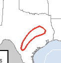
The Storm Prediction Center says they may have to issue a tornado watch during the night for the area indicated in red. No watch at this time, however.
Radar at 10:20pm shows strong thunderstorms from San Antonio to Austin to just west of Shreveport. It is in this general area where severe thunderstorms may develop later in the night.
Flash flooding also possible especially in the counties that include I-35 from San Antonio to Austin and one set of counties just to the east of those containing the highway.
 This is my last update for the night. More severe thunderstorms likely tomorrow farther east.

Radar at 10:20pm shows strong thunderstorms from San Antonio to Austin to just west of Shreveport. It is in this general area where severe thunderstorms may develop later in the night.
Flash flooding also possible especially in the counties that include I-35 from San Antonio to Austin and one set of counties just to the east of those containing the highway.


Comments
Post a Comment