Posts

Showing posts from July, 2013

Kristin on Anthony Weiner

Normally, this would be a blog "Sunday Funny" but it will lose something if not timely. As you know, Kristin is one of my favorite singers of all time.

They are Called R-A-W-I-N-S-O-N-D-E-S

Image
How many times have you heard a television meteorologist refer to "upper air data" or "weather balloons"? I'm sure it is many times. They carry a small instrument package (in his left hand) that reports on pressure/altitude, temperature, humidity, and -- by tracking its ascent and drift -- the wind speed and direction at various levels above the ground. Ever wonder what happens to the weather balloons? After all, what goes up must come down.  Here is what it looks like. The parachute is at lower left. The weather stations listed on these maps routinely launch the balloons. Note the "WAL" which is the three letter identifier for Wallops Island, VA. Well, a funny thing happened in Norfolk, Virginia, yesterday evening: They called the bomb squad! And, yes, one lady thought it was an extraterrestrial. Good thing they didn't call the TSA. The entire neighborhood would still be enduring grope searches!

Let's Focus on the Really Big Threats

With all of the global warming, NSA, TSA nonsense going in Washington, as usual, our government is focused on the wrong things. Rather than spending money on re-re-determining men get killed by lightning more often than women , let's focus on the huge threats for which we need  government coordination: Pry, Cooper, and former CIA Director James Woolsey have been recently demanding that Washington prepare the nation's electric grid for an EMP, either from the sun or an enemy's nuclear bomb. They want the 2,000-3,000 transformers in the grid protected with a high-tech metal box and spares ready to rebuild the system. Woolsey said knocking out just 20 would shut down electricity to parts of the nation "for a long time." But Washington is giving them the cold shoulder, especially the administration. Woolsey told Secrets that some in Congress are interested in the issue, but the administration is just in the "beginnings" of paying attention. Just two

Severe Thunderstorm and Tornado Risk Increasing

Image
Here is the region where large hail and damaging thunderstorm winds are forecast (with a 15% probability at any given point) later today and tonight. For tomorrow and Thursday night: Very  damaging winds are possible in the hatched area. There could also be a tornado or two in the central U.S. outlooked area. And, for Friday and Friday night: Damaging winds and large hail expected in these areas in this preliminary outlook. Note: For a number of reasons, I will not be live-blogging storms for a couple of weeks.

Since When is Lightning a "Disease"?

Image
The Centers for Disease Control (CDC) tell us men are six times more likely to be killed by lightning than women . Of course, meteorologists have known this for decades. Okay, but why is the CDC even doing this work? Here is an article from 2009 that reaches the same conclusions . And, one from AccuWeather in 2011 with the same information. Last time I checked, neither bacteria nor virus nor fungus were part of the composition of lightning. So, it is hardly a "disease." We keep hearing the federal government is short of money but there sure seems to be a lot of duplication, mission-creep, and reporting the obvious.

U.S. and Cuba Cooperate When it Comes to Hurricanes

Dr. Avila called Cuba one of the United States’ most valuable meteorological partners. “Cuba has a long history of excellent forecasting with a tremendous record of data,” he said... And some experts on both sides wish that cooperation would extend to the nonmeteorological aspects of storms. The countries’ disaster management agencies have no direct communication. “Cuba manages hurricanes well,” said Russel L. Honoré, the retired lieutenant general who commanded military relief efforts after  Hurricane Katrina  devastated New Orleans in 2005. He has since become a specialist on disaster preparedness and has traveled to Cuba three times in recent years. “We could be learning from them,” he added. While it has one factual error (Cuba doesn't have any weather satellite with which to exchange data with the U.S.) this is a really interesting article from the New York Times .  Some of the history of U.S.-Cuban hurricane relations are chronicled is Eric Larson's excellent bo

The Quality of Climate Forecasts

Image
Ten days ago, after a U.S. Senate hearing, I wrote a three-part series on the near-complete inability of climate science to skillfully forecast future climate either at intermediate or long-term. Here is a quick recap: Dr. Roger Pielke, Jr. Disasters are not increasing .  Dr. Roy Spencer on climate science's models inability to forecast current climate trends .  A recap of some recent climate forecasts.  The Guardian  -- usually a pro-global warming newspaper -- today published an even-handed article about climate skepticism . I recommend reading it. I want to comment on this paragraph: Many climate sceptics worry climate science cannot be dubbed scientific as  it is not falsifiable  (as in  Popper's demarcation criterion ). They claim that while elements of climate science  may be testable in the lab , the complexity of interactions and feedback loops, as well as the levels of uncertainty in climate models, are too high to be a useful basis for public policy. The r

Tweet Says it All

Image

From the Mike Smith File

Image
Mike has been very busy lately with appearing recently on BBC World News, Fox News and granting interviews on how meteorologists and storm chasers save lives. Check out these links to learn more about the Mike Smith files. click here for storm chasers article click here to learn how meteorologists save lives Photo by Jaime Green Mike was also recently interviewed in The Wichita Business Journal  Click here for article

Kansas Flooding

Image
UPDATE: 11:10AM, Here is the rainfall across Kansas for the 24 hours ending at 7am. Note the 6"+ along the Kansas Turnpike southwest of Emporia where the road was closed yesterday evening. click to enlarge ORIGINAL POSTING: Flood warnings are out for the areas in green: U.S. Highway 50 is closed between Newton and Hutchinson due to flooding. I also suspect a number of local roads are flooded in the Flint Hills between about El Dorado and Emporia. The Kansas Turnpike is open this morning.

How Rainfall Varies

Image
click to enlarge Here are rainfalls across Sedgwick County, Kansas, this morning. You can see that amounts vary greatly over just a few miles. Below is the radar from yesterday evening as torrential rains moved in. The storm developed over this area (meaning it dropped no rain farther northwest). The area of thunderstorms responsible for the heavy rain was moving from northwest to southeast and never dropped any rain over areas to the west. So, the official National Weather Service rain gauge had just 0.01 inches while far northeast Wichita had 2.05 inches.

Kansas Turnpike Reopened, But...

Image
The Kansas Turnpike (I-35) has reopened. However, there may be areas of high water for the next several hours on the Turnpike and on U.S. 77 and 177 north of the Turnpike. US Highway 50 from Halstead to Emporia may also be hazardous. I makes sense to consider delaying your trip on these roads or others in the Flint Hills until daylight. KWCH TV got this image of travelers looking at AccuWeather's display system which is available at all of the major Turnpike rest areas.

Mama Mia II!

This video, taken earlier today in northern Italy, is inside an office building at is inside a tornado. At first, you see the rain of debris. Then, the debris gets thicker. At the 1:00 mark, the excitement begins. The wind starts whistling through the places where the building is not airtight. You can see the debris change direction of travel  after the center of the tornado passes.

Lightning Lesson: Invisible Danger

Image
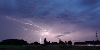
Kathleen and were hearing thunder -- without visible lightning -- a while ago even though it was not only dry, the radar was showing no rain anywhere near us. We were under a type of lightning known as an "anvil crawler." In this example, we are at the orange oval. While does not show up well on radar, we are under the anvil of the storm (dashed blue line). In this photo, the "core" of the pictured storm (the bright echoes on radar) is between the yellow arrows. The anvil is the white cirrus clouds that spread out ahead of the core. This is a time exposure of anvil crawlers at night. During the day, they are usually not bright enough to be observed by the human eye. So, how do the keep safe from the cloud-to-ground lightning that occasionally occurs from an anvil? I'm beta-testing AccuWeather's new SkyGuard® Mobile. It was going off well in advance of the thunder at my home. This is another example of weather science making us safer!

Serious Flood Threat Flint Hills Vincity

Image
Here is the AccuWeather Regional Radar across Kansas at 6:15pm. The greatest threat over the next three hours is the region I have outlined in light green. Flooding may occur along I-35 between Cassoday and Emporia. Remember: TURN AROUND, DON'T DROWN!

Heads Up Southern Kansas and Northern Oklahoma

Image
Large hail and damaging winds are quite possible. In southern Kansas, a (relative) weak tornado is possible. I'd call the risk of that "moderate."

Tornado Threat in Kansas Later

Image
Five percent is the significant threshold for tornado probabilities: People in the 5% area should monitor weather conditions if thunderstorms approach. Also, the flash flood watch has been expanded slightly since this morning. Scroll down to see what can happen when someone drives across a flooded road.

"Turn Around, Don't Drown"

Image
Below, I have posted two areas of flash flood watches. Some of the computer models are forecasting more than five additional inches of rain in the Kansas watch.  As recently as yesterday, a tour bus was swept away by floodwaters. Fortunately, no one was killed. By far, the #1 cause of deaths in flash floods is people who are perfectly safe driving into flooded areas. Please view the video below and Chris' commentary below. Turn around, don't drown! This very brief video shows how quickly things can go from safe to near-fatal. Chris says had his car not buckled and the window broken he never would have been able to get out. I'll let him pick it up in his own words. Published on  Jun 2, 2013 This is a view from my D-TEG dashcam. I approached a flooded road and made a quick U-turn rather than driving [all the way] into the water. This was a naturally smart move. Unfortunately my turn resulted in me plunging off a hidden embankment and splashing nose-first

Two More Flood Threat Areas

Image
In addition to the flood threat posed by Flossie in Hawaii, there are two areas on the mainland where flash flood watches are in effect: Here are forecast rainfalls for the next five days: Finally, large hail and damaging winds are forecast to occur in the yellow areas:

Flossie Will Flood Hawaii

Image
While the winds will cause some power outages, uprooted trees, and some building damage (especially in the higher elevations), the main effect of Flossie will be heavy rains. These heavy rains will end a drought. The worst effects will be to the islands of Hawaii, Maui, Lanai, and Oahu.

Ten Day Rainfall Forecast

Image
In some areas, this might be too much of a good thing. Here is the European model's ten day rainfall forecast that was run from this morning's weather balloon, satellite and other data: This remarkably consistent with last night's version: As always, don't focus on an exact point but rather then overall pattern.  The very heavy rain over the High Plains would be welcome in all areas because the drought continues very severe in that region. Yes, even if they received ten inches over ten days. In western Missouri, the east half of Kansas, and northern Oklahoma, there is a real danger of river flooding if these heavy rains materialize. While the corn and soybean crops look great right now (I was out looking at them yesterday), flooding cut ruin one of the most promising harvests in years.

More Potentially Good Environmental News

Image
From the Bulletin of the American Meteorological Society...

Flossie Headed for Hawaii

Image
Tropical storm warnings are in effect for Maui and the Island of Hawaii with a tropical storm watch in effect for Oahu (Honolulu's island). The winds will cause the problems, especially in the higher elevations. While there will be flooding, much of the State of Hawaii has been in a drought, so the storm may be a net plus. Because of Hawaii's geographic location, it rarely gets tropical storms or hurricanes even thought it is in the tropics. click to enlarge

The Drought is Ending

Image
The Smith House had another 1.62 inches up to 7:30am and it is still raining. At Wichita's Mid-Continent Airport, it is the 4th wettest July ever. We could easily move up to #2 before the month is out. Here is the rainfall for the last 24 hours. For the past seven days: But, here is the problem -- too much of a good thing. Flood watches  are out. This is the five-day rainfall amount forecast.

Sunday Fun: Train Chasing

Image
This is one of the coolest videos I have seen in a very long time and you do not have to be a train fan to enjoy it. It is of a small radio controlled helicopter chasing a BNSF train around the world-famous Tehachapi Loop in California. This video is in HD. I suggest before viewing setting it to 1080HD and then viewing in full screen. What is the Loop. It is a place constructed in the 19th Century to allow Southern Pacific trains (now Union Pacific with BNSF using it with "trackage rights") to get up the steep grade. The trains literally loop around themselves. See photo below with the locomotives indicated by an arrow. click to enlarge If you aren't a train fan, here are a couple of screen captures to help you figure out what you are seeing:  The train has climbed to the Loop's upper length, what you are seeing in the background is the same train. The train is rounding the curve at the upper level with the same train on the lower loop. And, f

Last Week's Pearl Jam Weather Delay

The weather delay at the Pearl Jam concert at Wrigley Field eight days ago made national news. What was most newsworthy is that (in contrast to the 2011 Indiana stage collapse), everyone was safe. In addition to the organizers doing everything right, AccuWeather Enterprise Solutions was on the case. You can read the genuinely amazing story of how we kept concertgoers in Chicago safe, while -- at the same time -- protecting trains in Mexico here .

70° at 10:20am in Late July...

...and you want me to blog? Sorry. Utterly without inspiration at the moment. I think the muse must be out enjoying this gorgeous weather. Please come back later today.

The Drought Shrinks

Image
More from AccuWeather .

Compilation of May Tornadoes in Oklahoma

Judging from the number of interviews I am still giving, there is a lot of interest in the Oklahoma tornadoes in May. So, I thought I would post this compilation video which can be viewed in HD (the "gear" symbol). The older man on the weather set is Gary England of KWTV. Gary announced his retirement from daily weathercasting this week. Gary started his career at KWTV when I was working at WKY-TV (now KFOR TV) in Oklahoma City. I wish him well in his future ventures . Note to people outside of the Great Plains: This type of coverage is routine in places like Wichita, Kansas City, St. Louis, Tulsa, etc. This is really the "big leagues" of television weathercasting.

Drought Slowly Going Away

Image
Here is the rainfall for the last 24 hours: We had 0.98 inches at the Smith House. I'll have full drought update later this morning.

How to Recognize a Downburst

Image
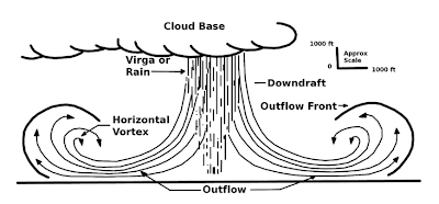
A downburst is small area of air that flows rapidly down from a thunderstorm, spreads out and accelerates causing damage and, twenty years ago, knocking airliners out of the sky. Here is a diagram of the air flow: During the severe thunderstorms in southern Kansas two evenings ago, photographer Beth Bodoin got two great photos of a classic downburst (by the way, they are called micro bursts when they are smaller than 2.5 miles in diameter). The of rain/wind outflow at the left is sometimes called the "toe" of the downburst. click to enlarge A photo she took a few minutes later (without annotation) shows a small cloud forming at the top of the rising air. Now, with the air flow added. There is some research that shows the rising air is only associated with winds of 50 mph or more. Want to be impressed by how quickly a downburst can turn dangerous? Watch this video: You can see the thicker rain and hail flowing in from left to right as the video progress

Flood Threats

Image
The first is tonight through Friday night in the central U.S. The area with the greatest potential for flash flooding are Cowley, Elk, and Chatauqua counties in Kansas and throughout northeast and north central Oklahoma (including Tulsa). The second is in the Southwest where monsoon summer rains continue.