
How to Recognize a Downburst
A downburst is small area of air that flows rapidly down from a thunderstorm, spreads out and accelerates causing damage and, twenty years ago, knocking airliners out of the sky. Here is a diagram of the air flow:
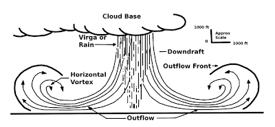 During the severe thunderstorms in southern Kansas two evenings ago, photographer Beth Bodoin got two great photos of a classic downburst (by the way, they are called microbursts when they are smaller than 2.5 miles in diameter). The of rain/wind outflow at the left is sometimes called the "toe" of the downburst.
A photo she took a few minutes later (without annotation) shows a small cloud forming at the top of the rising air.

Now, with the air flow added.

There is some research that shows the rising air is only associated with winds of 50 mph or more.
Want to be impressed by how quickly a downburst can turn dangerous? Watch this video:
You can see the thicker rain and hail flowing in from left to right as the video progresses. The downburst hits at the 2:36 mark.
Of course, the taming of the downburst is one of the stories I tell in Warnings: The True Story of How Science Tamed the Weather.


 |
| click to enlarge |

Now, with the air flow added.

There is some research that shows the rising air is only associated with winds of 50 mph or more.
Want to be impressed by how quickly a downburst can turn dangerous? Watch this video:
You can see the thicker rain and hail flowing in from left to right as the video progresses. The downburst hits at the 2:36 mark.
Of course, the taming of the downburst is one of the stories I tell in Warnings: The True Story of How Science Tamed the Weather.


I went through one here in KC that was unreported but quite scary. We had stopped under an underpass while the storm fury began to make visibility nearly impossible. Suddenly the wind became incredibly powerful that we fortunately faced straight into with our vehicle. I thought it was going to blow us away. It lasted a good minute.
ReplyDeleteFantastic video
ReplyDelete