Posts

Showing posts from April, 2022

Storm Shelters: The Other Half of Storm Protection

Image
Reposted from April 18 I'm delighted to announce I am working as a consultant for with Survive-A-Storm Shelters . For 50+ years I have worked to provide better and better storm warnings for the public and for enterprise customers. That is half of the storm protection equation. The other half is making sure you, your school or your business has a robust place to go when a tornado, hurricane or derecho is approaching.  We have some exciting things to announce in the near future, so stay tuned. In the meantime, if you are in the market for a shelter, please contact Mr. Taylor DeVane by clicking here . 

1,000 Buildings Affected; No Serious Injuries

Image
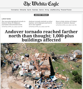
The aftermath of the Wichita-Andover Tornado of 2022 is astounding: One thousand buildings damaged or destroyed and no deaths and no serious injuries. It has a preliminary rating of a high-end EF-3.  Below is the Andover YMCA where the staff heard the warnings and took everyone to the basement. Imagine if the tornado had struck without warning! KAKE-TV News Part of this is good luck. But, the majority is due to weather science training people what to do and then the forecasts and warnings by dedicated and skilled meteorologists.  Congratulations to all meteorologists involved in warning the people of south central Kansas.  Addition: After posting this, it was brought to my attention that three storm chasers from the University of Oklahoma were killed on the way back to Norman last night.  As it turns out, they were chasing the tornado Kathleen and I saw touch down and reported . Meteorologists and storm chasers go into field to report on these storms to keep everyone else safe. What w

Spectacular Video of Last Night's Wichita-Andover Tornado

Image
This is among the most amazing tornado videos I have ever seen.  Based on the damage I have seen, it will likely be rated at least EF-3 intensity. As far as we know, there were no deaths and no serious injuries -- in spite of destroying or damaging more than 100 homes and other buildings. At the badly hit Andover YMCA, the staff got everyone to shelter after hearing the warning.  This was another case of weather science saving lives through timely, accurate forecasts and warnings. 

Unfortunately, The Forecast Was Correct

Image
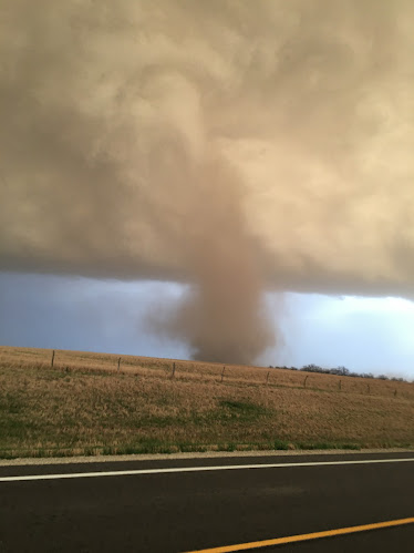
I took this photo just after 8pm. The tornado touched down ~100 yards in front of us and crossed K-15. The tornado is east of the road in the photo above. Our exact location is below. [Addition, NWS rated it EF-1.] This tornado damaged or destroyed two homes northwest of Herington.  If you've ever wanted to know what it looks like when a tornado first touches down, it is seen below (taken through my windshield). It is about 100 yards in front of us. There is no visible funnel!  That came 2-3 minutes later. In the background is the thunderstorm that produced the Andover Tornado. There was a far worse tornado which struck far southeast Wichita (50-100 structures hit, per our mayor) and then hit Andover. You'll recall Andover was struck by an F-5 tornado on April 26, 1991. The supercell thunderstorm that caused the Andover Tornado as seen from Durham, Kansas.  Here is the approximate path of the 2022 Wichita-Andover Tornado. The circles are rotation centers every four minutes. Bel

Tornado Watch: Kansas and Nebraska

Image
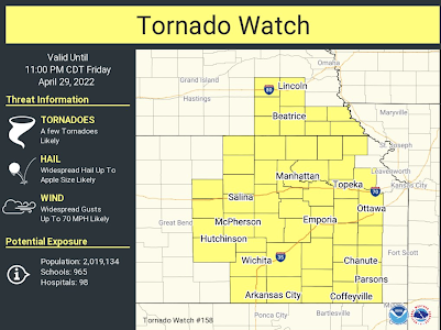
A second tornado watch has been issued for Kansas and Nebraska until 11pm CDT. While there is a chance of tornadoes throughout the watch area, I am especially concerned in areas north of U.S. 54.  In addition, 3" hail stones are forecasted to fall with the stronger thunderstorms.  Safety rules suggestions are below, scroll down. Note: this will likely be the end of my blog coverage today. I hope to get out and observe the storms. However, I will continue to post on Twitter @usweatherexpert.

Tornado Watch: Nebraska and Kansas

Image
This tornado watch is in effect from now until 9pm. Large hail, damaging thunderstorm wind gusts above 70 mph and tornadoes -- with strong tornadoes possible -- are likely.  See posting below for safety recommendations.  There will likely  be another tornado watch issued for eastern Kansas within the hour. 

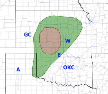
This Afternoon and Tonight's Tornado and Damaging Wind Risk

Image
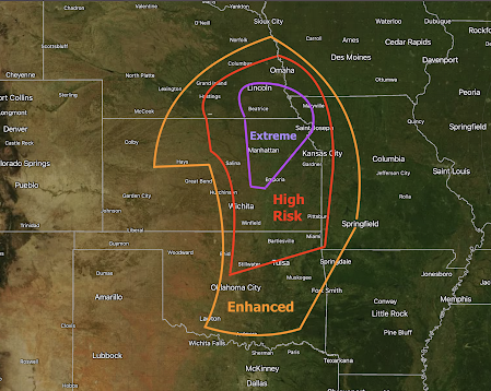
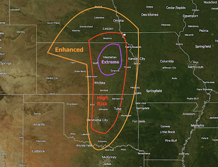
After 2 hours of analysis, here is my forecast on the tornado and severe thunderstorm risk starting at 3pm today and continuing until 3am Saturday morning. Giant hail (> 2") is likely with any thunderstorm in the extreme or high risk areas. Let's break it down: Extreme Risk Area:  Keeping in mind that this a relative  risk scale of tornado damage or injury, I have used the rare extreme category because of the risk of strong tornadoes and the risk any thunderstorm in this area could be accompanied by 90mph straight-line winds. Power failures and tree damage are likely. High Risk Area:  Any supercell thunderstorm in this area is a candidate to produce a tornado, perhaps a strong tornado. The thunderstorms could also produce 70 mph winds.  Enhanced Risk Area:   If  strong thunderstorms develop south of I-40, they are candidates to produce a tornado or two. In northern Kansas to the west of U.S. 81, an isolated tornado or two is possible.  Noon Addition While my forecasts are i

48-Hour Rainfall Amounts

Image
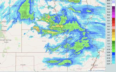
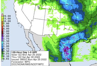
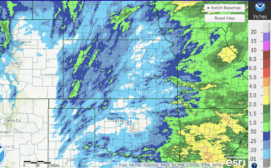
Yes, I am currently working on an updated tornado and severe thunderstorm forecast. In the meantime, here is a map of 24-hour rainfall amounts ending at 8am across the winter wheat belt. And, here are the 48-hour amounts.  And, the forecast rainfall amounts for the next five days. The rains are extremely beneficial for the wheat but are delaying corn planting. 

Tornado Forecast Friday Afternoon to Pre-Dawn Saturday

Image
Here is my forecast of the tornado risk in the central Great Plains from 4pm Friday until 3 o'clock Saturday morning.  This is the first time I have used an "extreme risk" on my 4-category scale (I'm not using the lowest category of "significant" because of the nature of this event). This one of those events where, if the cap (a layer of warm air about 10,000 feet above the ground) holds, nothing will happen in the two higher categories. But, if it breaks, violent  tornadoes become likely, especially in the extreme area. Let's break it down: Extreme Risk = Violent tornadoes possible; some occurring after dark. It is possible this area will be modified depending on where the warm front is going to end up.  High Risk = Strong tornadoes possible; some occurring after dark.  Enhanced Risk = A few tornadoes; north of I-70 the tornadoes will likely end before ~8pm.  Throughout the high and extreme risk areas, giant hail is likely.  If you live in these areas,

Desperately Needed Rain in the High Plains

Image
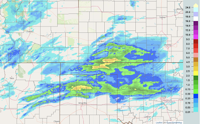
Far more is needed in the region but this is helpful.

Tornado Strikes Illinois Barn

Image
More tornadoes are likely as the week progresses. Stay tuned!

31st Anniversary of the Wichita-Andover F-5 Tornado

Image
Duke Evans By request, here are links to my two-part coverage of that tremendous tornado: Part One. Part Two .

Here Come More Shortages

You may have seem my tweets pertaining to the horrific lockdown in Shanghai and how it will deal another blow to the U.S. supply chain. There is a more detailed article here . I believe the situation is why the stock market has been suffering so much the past week.  The volatile situation in China is one of the reasons I have recommended keeping extra supplies of essentials.  Changing the subject, now that Twitter has freed by Elon Musk, how about following me @usweatherexpert ?

Forecast Rainfall Through 7am Saturday

Image
The winter wheat belt is forecasted to miss most of the rain this week.  Below is last week's rainfall (ending 7am this morning). While the rain in the High Plains was appreciated, it was little more than enough to settle the dust in most areas. The rain in northwest Texas and southern Oklahoma was needed and enough to lessen the drought. Meanwhile, it continues to be too cool and wet for corn planning in many areas. 

72-Hour Rainfall Ending at 8am

Image
Here is the 3-day rainfall across the winter wheat belt. 

Sunday Fun: Whale Hail!!

Image
The 50th anniversary of one of the greatest TV news reports in history. Too bad the television stories are no longer long enough for this type of in-depth reporting. 

Today's Tornado Risk

Image
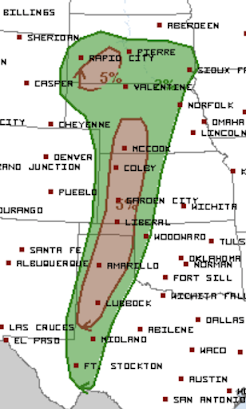
The brown areas have a significant tornado risk this afternoon and tonight. Unfortunately, there was significant damage in northwest Kansas from tornadoes late last nigh t. If you are in the brown areas, please keep up on the weather today and tonight. 

7-Day Rainfall in the Winter Wheat Belt

Image
Rainfall to 7am today. Most all of this rain has fallen the last 72-hours. 

Another Doom Forecast From Big Climate Falls on Its Face

Image
"The end of the Maldives...could come sooner if drinking water supplies dry up by 1992, as predicted." We covered the announcement of all of the new hotels and the four airports on the 'doomed' Maldives. I didn't realize the airports were completed. On the 9th, a climate scientist asked on Twitter, "What can I do?' She believes global warming will be a catastrophe. [I believe it is a significant problem.] I replied, "Tell the truth!" Stop trying to make forecasts of things we cannot possible forecast with accuracy. Every time Big Climate (of which she is part) tries to do this, it kills the credibility of the science. 

Today's Tornado Risk

Image
The brown areas have a significant risk of tornadoes. The bigger threat late this afternoon and tonight is damaging thunderstorm winds accompanied by large hail. Please keep up on the latest weather information in these areas!

Blizzard Warning: Northern High Plains

Image
Yet another blizzard is forecasted to occur in the northern High Plains from late Friday into Saturday. It is likely I-94 will be closed again.  Color code: Orange = blizzard warning. Purple = winter weather advisories  Deep green = winter storm watch Green = flood advisories  Maroon = fire danger warning Browns = high wind watches and warnings Please factor this information into your plans. 

Extraordinary Wildfire Risk Friday

Image
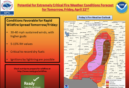
Don't smoke outdoors, don't drag chains, don't do anything  that risks starting a fire!

Tornado Watch for Kansas

Image
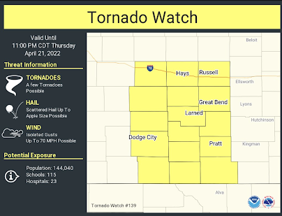
Tornado watch with "a few" tornadoes and hail up to 3 inches in diameter. 

Iowa Flood Risk

Image
More than ten inches of rain is forecasted to fall in Iowa over the next five days, with much of it coming tonight through Sunday night. It is important to consider what you would do if flooding threatened your home. And, always, the #1 thing to avoid in floods is this: Never try to cross a flooded area by foot or by car. 

Today's Tornado Risk

Image
The brown area has a significant risk of tornadoes if  any strong thunderstorms develop. And, if  strong thunderstorms develop in the brown or green areas, hail ≥ 2" is likely.

Tornado Risks Today and Thursday

Image
There is a significant risk (brown) of tornadoes over eastern Oklahoma later this afternoon and evening.  Thursday, there is a significant risk of tornadoes in central Kansas and far northern Oklahoma.  Within the tornado risk area is the likelihood of giant hail ( ≥ 2 inches). If you live in these areas, I urge you to keep up on local weather information. 

Some Reminders About Flood Forecasts

Image
With heavy rain in the forecast, please keep these definitions in mind.

With the Supreme Court Considering the Fate of Roe vs Wade...

Image
 ...it is nice to know the White House is in favor of striking it down!

What To Do When Tornadoes Threaten?

Image
Wichita's Meteorologist Lisa Teachman With the festering issues in the tornado warning program, I had a Twitter follower ask a few minutes ago ask the question, "If we can't trust the tornado warnings, what do we do?" I'm not saying you can't trust the tornado warnings: Most NWS's output is reasonably good. However, the quality of tornado warnings is clearly inferior to a dozen years ago. So, here's what I recommend: Get off the trash apps and trash Twitter accounts . If a Twitter account is not associated with a meteorologist  you can verify online, unfollow it!! Television is your friend : When a tornado watch is issued or when a severe thunderstorm warning is in effect, get off the internet and turn on TV.  For example, in Wichita (my home TV market) both Lisa Teachman (KSNW-TV) and Jay Prater (KAKE-TV) are both willing to "tell it like it is" when tornadoes threaten. In Kansas City, Bryan Busby will, too. Unfortunately, I haven't rece

James Spann on the Increasing Issues With the National Weather Service's Tornado Warning System

Image
James Spann, one of the meteorologists I most admire, has written an outstanding piece on the crisis in the tornado warning system. The entire essay is here . I encourage you to read it in its entirety. Some excerpts: I write this to point out a systemic issue that is growing, and is creating significant deterioration of the current NWS Watch/Warning system. Which in turn, will put lives in danger as people lose faith in weather warnings. I can only hope this debacle sheds light on the increasing issue of the number of high false alarms, constant hyperbole, and fear mongering prior to and during severe weather events. The public is being desensitized, and tornado warnings are losing their meaning.  Some NWS offices choose the “carpet bombing” method during severe weather threats, leading to False Alarm Ratio (FAR) values over 80 in some cases. Warning after warning after warning with no verification is simply crying wolf, and it has to stop.   We can’t catch every EF-0 tornado that is

Happy Easter Everyone!!

It is the most important day of the Christian calendar: the day Jesus saved us by overcoming death.  Hope it is a holy and joyous day for you and your family!

Investigative Report: Was the National Weather Service Bamboozled Into Issuing False "Tornado Emergency" Warnings Friday Evening?

Image
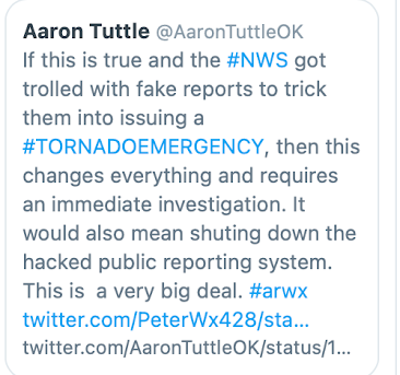
Investigative Report © 2022 Mike Smith Enterprises, LLC As of Saturday evening, there are numerous accusations the National Weather Service (NWS) was hacked, tricked or trolled into issuing false tornado warnings for northern Arkansas Friday evening. It may have been a deliberate effort to induce false warnings.  I, and some of the most prominent meteorologists in the United States, believe this is an extremely serious situation as the credibility of the NWS's vital storm warning system is at stake. A formal, independent investigation is needed. In addition, some meteorologists have come to believe that Tornado Emergency and similar products should be retired.  Normally, because of Easter tomorrow, I would wait until Monday to publish this report. However, because of the issue of debris and damage, it is important to do any investigating as quickly as possible after the storm.  The Background Within the National Weather Service's now ultra-complicated tornado and storm warning