
Monday's, Tuesday's and Wednesday's Tornado Outlooks
The purpose of this posting is to give you and you families/friends -- call them! -- the time and information you need to prepare for what could be a major outbreak of violent tornadoes.
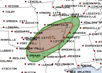 The brown area has a "significant" risk of tornadoes in the afternoon and evening hours. There will also be very large hail in the brown area and farther southwest toward Dallas and Waco.
 Translating to my risk system, the amber area has an enhanced risk of tornadoes and the yellow area has a significant risk. These may have to be upgraded later.
I use four tornado risk categories. They are:
- Extreme. In the three years since I have adopted this category, I have yet to use it. It is reserved for when I believe there will be both numerous tornadoes and that at least some will be ≥F-3 intensity. Time of day plays a role in this. If it is borderline situation, I will tend to go to the next higher category if strong tornadoes are expected after 9pm -- when people start retiring for the night.
- High. This is when strong tornadoes (≥F-2) are forecasted to occur along with sufficient density over the outlined area that requires frequent local weather monitoring once a tornado watch is issued.
- Enhanced. Either enhanced density or strong tornadoes.
- Significant. The risk of tornadoes is sufficient that it is worthy of your attention.
And, yes, there is an element of subjectivity to this. Now, the forecasts:
Monday

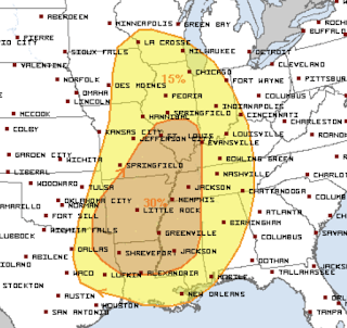
Tuesday
 This is the same forecast as below. There is no reason to change it at this point. This is potentially the most dangerous tornado situation in this part of the nation since 2012. It will be absolutely essential to follow the weather Tuesday in the high risk (red) area and in the orange (enhanced) area.

Wednesday
Wednesday's forecast comes from the NWS's Storm Prediction Center.

How to Use an Extended Tornado Outlook
- The first priority should be people. Make sure you can get yourself, your family and friends into a basement or storm shelter. Make plans now. If driving needs to occur to get people to safety, it should be done with the tornado watch is issued.
- If your school has not yet run a tornado drill in 2022, do it Monday. Make sure everyone knows the correct procedures. Decide Monday what you would do if a tornado threat should materialize with an hour of dismissal. Consider cancelling after-school activities.
- Allow employees to work from home after lunchtime on Tuesday.
- If you live in a mobile home, get out when the tornado watch is issued, unless you have a close-by storm shelter. Monday: Make sure the shelter is in good order.
- All shelters should have old shoes, a radio with fresh battery, a couple of bottles of water and a couple of diapers. Carry your prescription meds into the shelter.
- If you use a closet or bath in the center of your home, you might want to see if you can put some sort of head covering (football or baseball helmet, for example) on while you shelter. If you use the tub, put the matress in the bathroom so it is ready to go.
- We are putting our family heirlooms in the basement. I just backed up my computer and will do so again Monday. I will put the backup drive in the basement.
- Make room in the garage to put your car inside.
- Insure you have WEA warnings activated on your smartphone. In addition to WEA, make sure you have at least one other way to get warnings besides sirens and television. WeatherCall is a good choice.
- Get some extra cash at the ATM and fill your car with fuel Monday afternoon or Tuesday morning.
Of course, I will continue to update these forecasts.


Comments
Post a Comment