
Hilary's Forecast Path Shifts West; Updated 9:20am PDT
The forecast path of the center of Hilary has shifted a bit to the west. This increases the threat to the Southland, especially in terms of flooding.

 Because the forecast path has shifted to the west, that increases the threat of serious flooding in Los Angeles County north into Yosemite and the southern Sierra. It lessens the threat in Utah and western Arizona. While the threat of widespread flooding in Utah and Arizona lessens, note that some thunderstorms with localized heavy rain show up on the map.
In Nevada, the more western path increases the risk of serious flooding around Mt Charleston and into the central part of the state.

Wind
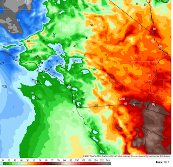 The maps above are the peak gusts forecasted with the storm. The highest winds, in general, are forecasted to occur in and east of the coastal range.
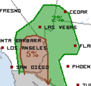 The brown area has a significant risk of tornadoes.
 More rain is on the way as the center of the storm moves north.

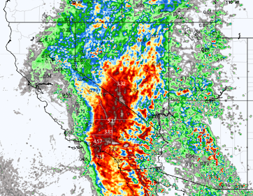
Rainfall

Note the heavy rains are forecast for Los Angeles County. Serious flash flooding may result.

Here is the updated (9am PDT) flash flood risk map.

There are already about 40,000 people without power in California, mostly in the center of the state.


Tornadoes

If you live in this region, please make sure you have multiple ways to receive storm warnings.
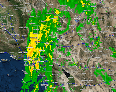
Current Conditions
Below is a radar map of the rain currently falling in the south California as of 7:35am PDT.

Here is the 48-hr rainfall to 8am PDT.


Comments
Post a Comment