
Another Tragic, Poorly Warned Tornado
 |
| WLNS TV, Lansing |
Everything pointed to a tornado warning being issued -- but it wasn't -- until the tornado was on the ground, doing damage.
I am going to review this case as an illustration of why the USA desperately needs a National Disaster Review Board to determine why the National Weather Service's tornado warning program has gone so far off course as compared to its high quality from about 2000 to 2010.
Atmospheric Conditions
Conditions were ripe for tornadoes yesterday evening in central Lower Michigan. The "Significant" (meaning EF-2 intensity or greater) Tornado Parameter was at a high value of 5 (2 is generally thought of as the threshold).


It does say, "A tornado or two possible." We've talked on numerous occasions that I believe if tornadoes are "possible" then a tornado watch should be issued. The rule change several years to allow these "severe thunderstorm with tornadoes forecast" watches should be changed back.
It should be noted their forecast of 85 mph winds was excellent and provided notice of the extreme thunderstorm-generated winds that occurred with these storms. Power outages were quite widespread with more than 600,000 people in Michigan without power.
Why A Tornado Warning Should Have Been Issued Earlier
This tornado warning situation, like so many others we've discussed, was straightforward. Before the tornado formed, we had:
- An atmosphere conductive to tornado formation that was getting more conductive with time. The VAD winds (won't go into what those are but meteorologists know) from 0 to 1km from the Detroit Terminal Doppler Weather Radar ahead of the the storms reached a sky-high value of 500+! That is high enough for the atmosphere to create strong tornadoes.
- We had a radar situation with "an isolated cell ahead of a line." We've known, based on "pattern recognition," that is a favorable situation for tornado formation since the 1970's.
- Once rotation formed (see below), it rapidly increased so that, given the above, a tornado warning should have been issued.
- And, finally, a good rule of thumb is -- if one tornado has occurred, given a favorable atmospheric environment, keep a special eye out for more. There had been a significant tornado in the northern suburbs of Grand Rapids (GRR) earlier. See comment from a GRR meteorologist immediately below.

The storms continued to move east toward Lansing. Below is an image from 8:58pm showing the storm ahead of the the line of thunderstorms that would aid in the development of the tornado.

As the cell and line merged, we started to see loose rotation at 9:09 pm over south Lansing (not shown). I would not have issued a warning at that point. Below is the sequence of radar images that would have prompted me to issue a tornado warning.
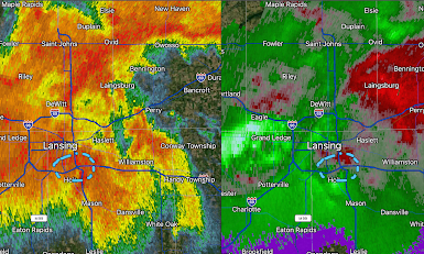 On the left is the radar's "reflectivity" data, which is the type of radar you see on television. It indicates how hard it is raining and where hail may be located. On the right is the Doppler wind data. Greens are winds toward the radar (located northwest of Detroit) and red are winds away from the radar. I've put dashed lines around the then-tightening rotation.
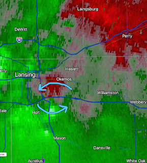 I've zoomed in on the Doppler wind data and it shows the rotation continuing to tighten over I-96 in the southeast part of Lansing.
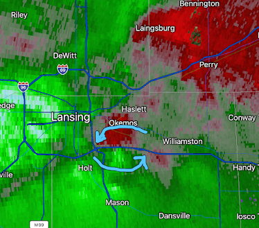 Three frames in a row with tightening rotation in an environment quite favorable for tornadoes. Had I been working the storm warning desk at WeatherData, Inc., I'm certain I would have issued a tornado warning for my clients at this point. There was no tornado warning from the National Weather Service.
9:12 Radar Image

9:14 Radar Image

9:17 Radar Image

9:31pm Radar

At left, the "correlation coefficient" data. It is showing lofted debris over I-96 (circled). Obviously, damage is occurring but no tornado warning is in effect.
9:34 pm -- the Tornado Warning Is Finally Issued
Even though lofted lofted debris was detected by radar 3 minutes earlier, the tornado warning says merely, "radar indicated tornado" rather than the stronger "tornado confirmed by radar" language which the NWS is allowed to use. Social science tells us that phrases like "confirmed tornado" are more likely to motivate people to take actions to save their lives.

Radar 9:36pm
Unfortunately, things were going from bad to worse, at least as measured by radar.

It may be fortunate the tornado went down I-96 rather than directly through the towns of Williamson and
Webberville.
From WLNS TV, Lansing: As of 3 p.m. Friday, the National Weather Service said that the tornado that hit between Williamston and Webberville was rated as an EF-2. This means winds were between 111-135 mph. The exact path of the tornado will be released later.
So, the storm was EF-2, a "strong" tornado on the National Weather Service's scale.
[Addition]

It is unclear whether one or two people were killed by this tornado...news reports seem to conflict. Whether an earlier tornado warning would have made a difference is unknown. Again, this is why we need a National Disaster Review Board, modeled after the hugely successful National Transpiration Safety Board to determine the issues here, with the horrific fire in Lahaina, Maui and other recent situations. If you haven't already, please contact your congresspeople and ask them to consider this request.
[Second Addition]
The comment below is from Matthew Herbert, a storm chaser who lives in the Lansing area. Please click to enlarge his entire piece but his key comment is:
The injured and deceased deserve an explanation as to why something that would have likely been warned for from the late 90s until recently wasn't warned in time from what is supposed to be the official source of warnings.
 |
| Click to enlarge |
Addition:
More info on the tornado is below. Note: if the tornado touched down at 9:29pm and the warning was issued at 9:34, the "lead-time" was negative five minutes.


Comments
Post a Comment