Posts

Showing posts with the label Michigan

College Football: Could Someone Answer a Question? Updated.

Image
An excellent point! --- original post --- Why is the timing of college football games evidently top secret? This conforms with what the official NCAA rules say.  Like many, I was appalled by the outcome of last night's Western Michigan v Michigan game. Multiple sources, both TV and sports magazine, say the timing of all devices are synched. Great! That is as it should be.  I spent time with Grok last night and it, plus the NBC rules analyst, say the stadium and TV times displayed are the official time.  If so, then the clock expired while the ball was in the air and Western Michigan won. Period. Yet, there is an evidently a super-secret, password-protected, decoder ring, eyes-only timing system that is the ultra-special official, official-official game timing. And, it is the one (even though we can't see it) that determines the game. Absurd! This is an important point. Put a $3 GPS chip into each of these devices, set them to "countdown" mode -- problem solved! Now th...

Tuesday's Tornado Forecast - Updated 4:30pm

Image
This forecast has been updated. Scroll up.  Looks like another active day tomorrow and, since we want to make sure Governor Whitmer is informed , here is a tornado outlook. There are two risk areas, please scroll down to see both.   Midwest Tornado Risk - Updated 4:25pm Monday The yellow indicates an enhanced  risk of a tornado and, if one occurs, it could be strong (hatching). The brown indicates a significant risk of tornadoes with -- again -- a chance of a strong storm. This includes far southwest Michigan. With the update, I have put a small part of northeast Kansas and western Missouri into the "significant" tornado risk area. This is because it now appears the low pressure system and warm front will stay west and north -- respectively -- of the KC area.  I am also concerned that parts of the yellow area may need to be upgraded to a higher forecast risk category for late tomorrow afternoon.  The green means a 2% chance of a tornado which is a very smal...

Tornado Forecasting: Do We Have to Politicize Everything?! - Updated

Image
Governor Whitmer: If you wish to be helpful, get on the bandwagon for a National Disaster Review Board which would investigate situations like this with an eye to making improvements in the way we forecast and react to disasters.  Friday's forecast for southwest Michigan was poor. There were unforecast major tornadoes. While I don't like it, it happens. I've certainly made my share of poor forecasts over a 50+ year career. The forecaster(s) involved likely feels like kicking themselves and is resolving to do better in the future.  That stipulated, there were no cuts in tornado watch forecasters at the National Storm Prediction Center where tornado watches are issued which, by the way, is not in Michigan but in Norman, Oklahoma. President Trump had nothing to do with it. I suspect Governor Whitmer already knows it. Attempting to politicize a poor weather forecast is beyond the pale.  I also fault the Detroit News  for playing along . They didn't even contact the Nat...

Power Out 10 Days and Counting!

Image
Screen capture from AccuWeather. You may recall seeing this forecast posted on the blog ten days ago. Added to the ice storm warning was a notification that power failures would likely occur and to prepare. As Jim Cantore posted this morning, parts of Michigan are still without power!  Temperatures are well below normal -- in the teens or even colder -- in some locations. Of course, there were major winds and tornadoes on March 30 in Lower Michigan (below). Red = tornado. Black = wind gust ≥ 75 mph. Blue = wind gust 58-74 mph . That storm would have strained the ability of the state to repair the grid. That said, it is surprising it is taking this long.  Has America's ability to recover from natural disasters waned? I don't know. This is why we -- desperately -- need a National Disaster Review Board modeled after the hugely successful National Transportation Safety Board. 

The Opposite of Environmentalism....

Image
.... this is nothing but another political grift in the field of climate alarmism.  From meteorologist and statistician Matt Briggs.  More and more, climate alarmism is about money and power.

Tornado and Severe Thunderstorm Forecast for Tuesday

Image
It looks like tomorrow will be a major tornado and severe thunderstorm day in the Midwest. I recommend people start planning accordingly. There is a high  risk of damaging storms. Tuesday's Tornado Risk There is an enhanced risk of strong tornadoes  in the yellow, hatched area. There is a significant risk of tornadoes in the brown area.  Tuesday's Damaging Wind Risk Here is the color code for this forecast: Purple: a high risk of wind gusts of 75 mph or stronger. Red, hatched: there is an enhanced  risk of wind gusts of 75 mph or stronger.  Red (only): an enhanced  risk of wind gusts of 60 mph or stronger.  Yellow: a significant risk of wind gusts of 60 mph or stronger.  There is also the risk of large hail in the above areas. A derecho may occur. Please factor this forecast into your plans Tuesday and Tuesday night.  Yesterday's forecast , unfortunately, worked out pretty well. It is almost certain there were more tornadoes in Kansas than sh...

Tornado, Hail, and Wildfire Forecast for Tuesday [Updated, 4:45pm]

Image
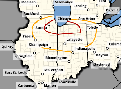
There is a significant risk of tornadoes tomorrow in the Midwest after about 4pm. The first of the severe thunderstorms will probably develop over Illinois. The area in orange has a significant risk of a tornado. The area in red, which includes Chicago, has an enhanced risk.  There is also a risk of giant hail -- two inches or larger -- in the hatched area. In the remainder of the yellow area, there is a significant risk of 1" or larger hail. There is also a critical wildfire risk of wildfires in the red area over the southern High Plains.  Of course, I will update on these risks tomorrow. 

Another Tragic, Poorly Warned Tornado

Image
WLNS TV, Lansing This time it was in central Lower Michigan. After dark. The time when the National Weather Service (NWS) says tornadoes are most dangerous.  Everything pointed to a tornado warning being issued -- but it wasn't -- until the tornado was on the ground, doing damage.  I am going to review this case as an illustration of why the USA desperately needs a National Disaster Review Board to determine why the National Weather Service's tornado warning program has gone so far off course as compared to its high quality from about 2000 to 2010.  Atmospheric Conditions  Conditions were ripe for tornadoes yesterday evening in central Lower Michigan. The "Significant" (meaning EF-2 intensity or greater) Tornado Parameter was at a high  value of 5 (2 is generally thought of as the threshold).  The NWS Storm Prediction Center, in spite of its forecasts earlier in the day (see: here   ) that there was a significant risk of tornadoes, chose to go with a s...

Major Tornadoes in Michigan This Evening

Image
Tragically, Two Fatalities Caused By the Tornado  East of Lansing Power is out in much of Lower Michigan at this time. More than 340,000 homes = ~800,000 people.  A strong or even violent (EF-4 or stronger) struck the Williamson - Webberville areas. There are reports of cars in trees and buildings that have collapsed. It touched down about 9:29-9:31p. The image below shows lofted debris (top image) along I-96.  At 9:36pm, the tornado, based on radar, reached its maximum strength.  There is a technique for measuring tornado intensity via radar. Its results are below.  The path, derived by radar, is below. It more or less paralleled the freeway for a few miles. The blue indicates a possible strong tornado. There is much more on the tornado, here . Tornadoes also occurred in the north suburbs of Grand Rapids and in the west and south suburbs of Detroit. There was significant damage with the former storm.  Addition: Downtown Detroit is at upper right. The red a...