Posts

Showing posts from June, 2021

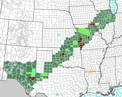
June 24 Palmer Drought Index

Image
Here is the latest Palmer Drought Index with data through June 24. Moisture conditions have improved in the Great Plains and remained wet in the Southeast. Elsewhere, dryness continues or has worsened in the last two weeks. 

Tropical Storm Warnings for the Windward Islands

Image
I wasn't expecting this already. The yellows indicate a tropical storm warning.  Beyond the first three days, this is a low-confidence forecast. That is a good reason for vacationers in this region during the Independence Day weekend to keep a weather eye out. 

Tropical "Heads Up"

Image
Generally, we don't discuss tropical threats beyond five days into the future. However, with the Independence Day weekend combined with forecasts of the most travel for any holiday weekend, ever, I thought it was worth posting this. This is the five day forecast from the National Hurricane Center. If you are headed to the Caribbean, Cancun, or even south Florida, it will be a good idea to keep a weather eye on local forecasts. 

Damaging Wind Event Likely in New England

Image
Essentially from Albany to Boston and Portland, a major thunderstorm-generated wind event is likely today.  At this time, thunderstorms are developing in Upstate New York. Please monitor the weather in the orange and yellow areas!

"Apple Daily" -- A Voice For Freedom Extinguished

Image
Hong Kong's Apple Daily  is no more. That plucky voice for freedom was snuffed out by the inhumane Chinese Communist Party. Bari Weiss has more .    Meanwhile, it is a tragedy that most of the media in the United States has thrown away its credibility via political advocacy and nonsense reporting. 

Damaging Wind Event for New England

Image
The NWS is forecasting a major damaging wind event due to severe thunderstorms tomorrow in the Northeast. There is a significant risk of wind gusts above 60 mph in the yellow area and an enhanced risk in the orange area.  I'll have more on this threat tomorrow morning.  In the meantime, it is a good idea -- especially in the orange area -- to prepare for the power failures. These include: Fill your auto with fuel.  Extra cash (credit card machines do not work in power failures). Special provisions for infirm friends or relatives, including power for medical devices and cooling for medicines such as insulin. 

Electric Vehicles: Told You So!!

Image
Oops. The government bribed (through massive tax credits) people to buy electric vehicles and install unreliable wind mills to generate power. How's that workin' out for you? The only way electric vehicles make sense, presuming we want to decarbonize energy (I do), is to embark on a massive, urgent campaign to install nuclear and hydroelectric energy (bet Californians wish they had built many more reservoirs) and -- where practical -- geothermal.  Current federal energy policy makes no sense whatsoever. Current proposals in Washington are for more of the same nonsense . Thus, I have concluded that Big Climate does not want to make progress on climate-related issues as much as it wants to have an 'evergreen' political issue.  Worse, many of the states (Texas and Kansas, I'm referring to you, among others) are going down the same paths to ruin. 

Happy, Happy, Happy Birthday...

 ... to Mel Brooks!! May he live another 95 years. We need the laughs.

Update: Flood Risk in Central United States

Image
The flash flood (green) watch has been expanded, so I wanted to update the information. Bright green is a flood warning and maroon is a flash flood warning.  Here is the forecast rainfall amounts for the 3-day period ending at 6pm Thursday. Click to enlarge.  Below is the radar as of 5:45pm CDT. If you are under a flash flood watch, I urge you to monitor local media for any flood warnings.

More Flood Potential Through Noon Wednesday

Image
The dark greens are flash flood watches. I'm surprised there is no flash flood watch out for southeast Kansas.  UPDATE: A flash flood watch has now been issued for southeast Kansas.  The light greens are flood warnings. The maroon is flash flood warnings.  The NWS's 3-day rainfall forecast shows the heaviest rains are forecasted to occur in southeast Kansas and southeast New Mexico with five inches forecasted to fall in spots.  Given the saturated ground, flooding is likely to occur if these heavy rainfalls materialize.  Update 12:30pm with 12-hour rainfall amounts:

"Page Turner"

Image
This came in my Twitter feed today. This is a great book for your Independence Day weekend or summer getaway.  To learn more or order a copy, go here . Or, visit your local bookseller.

Sunday Fun: Today's "Scientific Method"

Image
At OU (back when dinosaurs roamed the earth), I was required to take an upper-division course on the history of science and the scientific method. Somethings really were better in ancient times.    Scientific Method, 2021 Thank you, Jo Nova

Overnight Flash Flood Threat in Oklahoma and Adjacent Areas

Image
Here is the rainfall during the 24 hours ending at 10pm. There is a serious risk of flash flooding overnight as more heavy rain is falling in this area. More moderate to heavy rain likely in the central and southern Great Plains early next week. 

Needed Rain Falls in the Midwest and Central Great Plains

Image
Needed rains fell over the farmland of the Midwest and Great Plains where most crops were suffering from moisture stress. While some areas had too much (the red colors) and the rains interrupted wheat harvest in Oklahoma and Kansas, the vast majority welcome the rains.  A closeup of Missouri and Kansas depicts the heaviest of the rains during the last 48 hours.  More than 14 inches fell just northwest of St. Joseph. Nine inches of rain fell in central Missouri and in the Flint Hills of Kansas.  The excessive rainfall forecast worked out very well. The shape below was posted Wednesday (scroll down) and depicted the area where heavy rains would occur from Thursday to this morning.  While a small area of very heavy rain north northeast of Wichita was just outside of the polygon, all of the rest fell within. This represents a step forward in meteorology over the quality of forecast that could have been made as recently as 2010. Additional heavy rains are forecasted to occur over the next

Torrential Rains Accumulating From Central Kansas to Illinois

Image
Updated Flash Flood Risk Forecast as of 8:45pm valid until 7am.  -- original post -- Since noon today, heavy rainfalls have fallen from north of Wichita to central Missouri. Approximately nine inches have fallen in the purple area. That's a once in fifty year amount for eight hours.  During the last 30 hours (since noon Thursday), extreme rains have fallen in the central Great Plains and Midwest. Record flooding is occurring on a number of streams in Missouri.  As of 9:45pm torrential rains are falling in the red areas.  More torrential rains are likely between now and noon Saturday. Please keep keep in mind that these amounts are approximate and could shift a bit. Orange is 5" and amber (SE Kansas) is 7inches

Dangerous "Train Echo" = Flash Flooding Setting Up

Image
This is a radar map of eastern Kansas and western Missouri. The thunderstorms -- which are causing heavy to torrential rains -- are lining up in what meteorologists call a "train echo" (TE). In a TE, each of the thunderstorms move down the line like the train cars move down the track. Extreme rains can accumulate in these situations, leading to major flash flooding.  Please click on the illustration to see if you are in these areas and, if so, be prepared for major flooding. 

Flash Flood Risk Now Through Saturday Morning

Image
The red area has an enhanced risk of flash flooding this afternoon through Saturday morning. As much as seven inches of rain could fall in a short period of time.  Remember: do not try to cross flooded areas by foot or by car. 

Downburst in Northeast Wichita

Image
For the second time in my life, a downburst came down directly on our home. We had pea-sized hail, torrential rain with visibility of 20 feet and wind gusts to at least 60 mph that caused the leaves to pour off our trees. It began at my home at 12:57pm. Our next door neighbor lost about half of one of their trees.  The Wichita Terminal Doppler Weather Radar (TDWR), which is designed to see downbursts, did a great job of depicting what was happening on the ground. 12:59pm Left image is the type of radar you see on TV. It shows how hard it is raining. At right is the Doppler wind velocity data.  1pm The blue dot is my home. Jabara Airport (KAAO) is one mile east southeast of us.  At 1:01pm, Jabara Airport had a wind gust of 57 mph.  Addition: Report of power poles knocked over in the area where the TDWR showed the highest winds. In the 1970's and 80's, downbursts were the #1 cause of airliner crashes . Thanks to the TDWR installations, along with airport wind shear detection syst

Tornado Risk This Afternoon and Evening

Image
The brown areas have a significant chance of a tornado. Please monitor the weather in these areas when thunderstorms approach. 

More Flash Flooding Likely Tonight

Image
More flash flooding is forecasted to occur later today and tonight, especially in the red area. More than a foot of rain fell overnight Flooding is reported this morning in central Missouri as well as in the region where Kansas, Missouri and Nebraska intersect where just over 12 inches fell.  Over the larger region, needed rains fell in many parts of the Midwest and central Great Plains. Most of these areas were suffering from a rainfall deficit so they are most welcome.  The 5-day rainfall forecast has additional rain forecasted in a broad stripe from around Detroit to southeastern New Mexico

8:15pm Weather Update

Image
The area where tornadoes are possible is now down to a small area in Kansas.  As the tornado threat decreases, the flood threat has greatly increased. Already, one weather station in southeast Nebraska has reported 6.3 inches of rain. Totals of more than 8 inches are likely in the hatched area tonight.  Added 8:35pm. The black hatched area of Missouri (northeast of Kansas City) below is where damaging winds may occur from now until midnight. The threat area includes Excelsior Springs as well as Columbia and Jeff City.

Midwest: Flash Flood Update

Image
There is a serious risk of flash flooding tonight in the outlined area. Rainfall amounts in places will exceed six inches.  Whatever you do, do not try to cross flooded areas by foot or by car. If you live in a flood-prone area, put together a "go kit" of family heirlooms and other essentials in your car now so that you can quickly move to higher ground if water begins rising rapidly. Over the northern half of Illinois, heavy rains will develop after midnight giving a risk of flash flooding but the risk is not quite as great as in the outlined area.  Addition: 5pm National Weather Service flash flood watch in green. Yellow is their tornado watch. 

Central Great Plains Tornado and Severe Thunderstorm Risk Update

Image
Update: 3:50pm. National Weather Service has issued a tornado watch valid until 10pm. Note, that like me, they are forecasting "strong" tornadoes. I would not be surprised if they extended this farther to the south and west (see original posting). -- original posting -- This is my forecast of the highest tornado risk from 4:30pm until 11pm. There is the possibility of strong tornadoes.  Below is the NWS's forecast of damaging winds -- hatching is a forecast of gusts above 75 mph -- from 6pm until 1am. Power failures are likely on at least a scattered basis.  Giant hail (≥ 2") is forecast to occur in the hatched areas. I'll have an update on the flash flooding risk soon.