Downburst in Northeast Wichita
For the second time in my life, a downburst came down directly on our home. We had pea-sized hail, torrential rain with visibility of 20 feet and wind gusts to at least 60 mph that caused the leaves to pour off our trees. It began at my home at 12:57pm. Our next door neighbor lost about half of one of their trees.
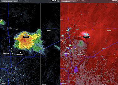
The Wichita Terminal Doppler Weather Radar (TDWR), which is designed to see downbursts, did a great job of depicting what was happening on the ground.
12:59pm
 |
| Left image is the type of radar you see on TV. It shows how hard it is raining. At right is the Doppler wind velocity data. |
 |
| The blue dot is my home. Jabara Airport (KAAO) is one mile east southeast of us. |
At 1:01pm, Jabara Airport had a wind gust of 57 mph.
Addition: Report of power poles knocked over in the area where the TDWR showed the highest winds.
In the 1970's and 80's, downbursts were the #1 cause of airliner crashes. Thanks to the TDWR installations, along with airport wind shear detection systems, we have gone more than a quarter-century without one of these crashes in the United States.
From KAKE-TV, more on the downburst's damage here. Note the downed utility poles in the background.


Comments
Post a Comment