Posts

Showing posts from October, 2023

Lower 48 October Rainfall

Image
The map above is the total rainfall for October. This map represents whether the amount of precipitation was above or below normal. 

Happy Halloween

Image
Halloween is about the time of the transition from rain to snow in the northern part of the county. So I thought this would be a good time for a reminder.

Otis' Devastation in Acapulco

Image
Here is a satellite view of the utter devastation from Hurricane Otis on Acapulco.  You will find much more information here . The death toll is now 100. If true, it is a miracle it is so low given a Cat 5 hurricane in densely populated area of one million.  Reports indicate the humanitarian situation is rapidly deteriorating. I would like to recommend a charity but the usual suspects (International Salvation Army, Catholic Relief Services, etc.) are not highlighting their efforts in Acapulco. If I find that something changes, I will let you know.  -- Additional Info -- Here is the wind speed data from the Mexican government. I believe this was from the Acapulco Airport.  Peak gust was 205 mph with peak sustained winds of 114 mph. I believe the eye would be a vertical line drawn through the "i" in the background.  Hat Tip: Cody Fields

Higher Taxes: Is There Anything They Can't Do?!

Image
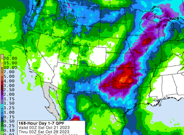
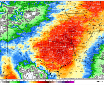
It is just amazing to me that some people -- regardless of government's frequent and overwhelming failures -- think the solution to everything is higher taxes.  The Washington Post's  story is ludicrous. Take this passage, for example: Livestock farming is a dynamo of greenhouse-gas emissions, contributing roughly 18% of the global total, in the form of carbon dioxide, methane from cow burps and nitrous oxide from fertilizer. This is not to mention the associated deforestation , pollution and biodiversity loss, all of which also warp the climate.  There are two types of cattle: those use for dairy and those used for meat. In the United States, the cattle used for beef (Kansas is the #1 beef producing state) graze in grasslands like the Flint Hills and Gyp Hills.  This area isn't, and never was, a forest.  The area is known as the "Tallgrass Prairie," because it is the last area of natural tallsgrass left in North America. It is the #1 area for cattle grazing in t

Last Week's Rainfall and a Look Ahead [Palmer Drought Index Added]

Image
Here is the Palmer Drought Index from right before the last week's rains began. Remember: oranges then reds are driest. Darker blues are wetter. While the rain missed Louisiana, they did occur in areas where they were badly needed. --- original posting --- We talked about the desperately needed rain in the central USA. Here's what actually fell during the past seven days.  We are not expecting any tornadoes or severe thunderstorms the next few days. Note the potential for flooding in the Northwest.

Sunday Fun: Santa Stayin' Alive

Image
For those of us who have attained a "certain age."

Weekend Fun: World-Class Cover Bands

Image
There is nothing like a great cover band that can handle more than one type of music. Over the last couple of months, I have found two terrific ones; one in the U.S. and the other in Australia.  The Lexington Lab Band is out of the Bluegrass State. It covers a huge array of music: from Johnny Cash to the Police. Three of my favorites are below.  The second cover band is SingIt Live from Australia. One of their singers, Nikki Heuskes, is amazing in the way she can sound like other female vocalists -- ranging from Dolly Parton to Linda Ronstadt and, especially, Olivia Newton-John. Some samples: Both groups cover many  more artists. The colored links will take you to more of the groups' music. Enjoy!

At Last: EV Industry Falling Apart

Image
Two news stories from yesterday. Daily Mail NPR In spite of massive  government subsidies, no one wants these cars. Which is good, given the child slave labor that goes into mining their ingredients.  Give me a great hybrid but EV's, except for certain cases, make no sense and are terrible for the environment. 

The Climate Brownshirts

Image
This was from The White House but it did not come to my attention until a little while ago. This group will no nothing about climate except what they are told by Biden people. In other words, they will be ignorant harassers. Per news media, they will be empowered to come onto your property and knock on your door without a warrant or permission from you. All in the name of 'preserving the earth.'  

A Climate Claim Contrary to Basic Meteorology

Image
There was an interesting item on LinkedIn last week. Climate science's latest "tool" is a reanalysis of world weather during the 20th Century. They take this reanalysis 'data,' put it in a climate model and, presto-chango,  we have a stronger storm than the one that actually occurred. What a surprise! 🙄 But there are good reasons to believe the output of the computer model is wrong.  The "climate" scientist promoting this finding, Dr. Ed Hawkins, is not educated in weather or climate. Per his Wikipedia entry: In no way do I mean to make this personal: A person who can obtain a PhD in Astrophysics is smart . But, that may not be the specific education needed to be a discerning climate scientist when I model provides questionable results. What do I mean? In a meteorology degree program, the first semester of your junior year, you learn about the atmospheric conditions that cause storms. One of the essential elements for a strong storm is a strong tempera

Devastation at the Hotel Where My Parents Spent Their Honeymoon In Acapulco

Image
This was the lobby of the Princess Hotel in Acapulco. Note the exposed infrastructure at upper right.  My guess is that the hotel will have to be rebuilt. The Princess has always been the pride of Acapulco. In 1951, my Dad didn't have that much money but he was absolutely determined to do well by his new bride. Take a look at this video from an upper floor . I do not know if the building at upper right was bent by the storm. We now have photos of what the ground-level damage looks like. Frankly, it looks much like the destruction from a strong tornado than a hurricane. Think of Hurricane Andrew in Homestead only a slightly stronger storm.

The Greatest "Guy" Invention Ever.

Words are not adequate. Click here . 

The Most Significant Rains Since May in Eastern Kansas

Image
Here are the storm total rainfalls to noon.  The deep red area northeast of Emporia is more than 10" and still raining.  And, the latest radar:

Damage From Otis

Image
This is the Diana Galleria in Acapulco.  Daily Mail

Acapulco About to Get Crushed By Cat 5 Hurricane Otis

Image
Hurricane Otis has rapidly intensified this afternoon and will make landfall with 165 mph winds and a dangerous storm surge headed for the coast of the Mexican State of Guerrero and the city of Acapulco.  More info available here .  Since posting the above, the forecast wind speed is now 150mph. If you have friends in the area, please get hold of them.

At Last: Rain!!

Image
Here is the amount of forecast rain... As of 7am CDT, here is the location of the rain. It is moving NNE.

Wind Turbine Refuse

Image
These turbine blade dumps are showing up in rural areas all over the country. Yet another aspect of 'green' energy. 

One of the Worst Ideas In the History of Mankind

Image
I can't believe -- especially with all that is going on in the world -- that global warming alarmists are still pushing geoengineering. It is a terrible, terrible idea. And, if it goes awry, which is probably will due to our lack of knowledge about the interactions between the ocean-earth-atmosphere interface, there will be no escaping its effects. Think about it: when the incredible tsunami struck the Indian Ocean in 2004, there were many, many locations (even just a few miles inland) where you could escape. But, because geoengineering is designed to affect the temperature of the entire earth, there will be no escape if it goes bad. 

Update on This Week's Rain Event

Image
Here is an updated forecast pertaining to rainfall amounts between now and noon Sunday (30th).  There are indicates there could be some locally heavy rains in the 5 to 8 inch range in isolated  locations. I expect to be able to get more specific tomorrow as the event draws nearer but, in the meantime, this is the area where any heavy rain may occur. I'll have another update tomorrow. 

The Overwhelming Hypocrisy Pertaining to Global Warming

Image
A quarter-century ago, most genuinely believed there was a serious climate problem and they were willing to make sacrifices to try to solve the issue. Not today. As we have discussed many times, the amount of hypocrisy related to this topic is off the chart.  Above is Skechers' " Our Planet Manners " portion of their website. But, does it truly matter to Sketchers? Evidently not! Given the state of the United States' airlines, I have nothing against private jets. I'd fly one if I could afford it. I do have a huge problem with hypocrisy. Sketchers is just the latest example. 

Sunday Fun: On the Soccer Bus

Image

Rainfall Outlook for Next Week

Image
Let's begin with weakening Hurricane Norma. It over the south part of the Baja Peninsula. It is moving ENE and it winds will dissipate over Mexico's mountains Monday. But, the considerable Pacific moisture will survive and slowly move northeast. A second Pacific low pressure system (not shown) will follow behind it and give the central U.S. two periods of significant rain. This is the rainfall expected for the upcoming week (until midnight Sunday, October 30). Of course, with this forecast extending a full week into the future, the rain area may move some in any direction. The rain is desperately needed in parts of Kansas, Missouri, Iowa and Nebraska (the rain will miss the worst of the drought area in Louisiana).   The rain will be especially helpful to the 2024 winter wheat crop which is being planted now or has just been planted (depending on location) in the central and southern Great Plains.

Suggestion for This Weekend

Image
The Babylon Bee brought this to its readers partly tongue-in-cheek but I believe we should take it seriously. Think about the issues in our nation and throughout the world. We need God's help more than ever.  So, go to church this weekend!!

Update on Southern Plains to Midwest Rain Event

Image
Some areas will receive the heaviest rains they have received in months. The map below is a forecast of rainfall amounts between now and Friday evening.  This NWS forecast calls for the heaviest rains (5"+) in far southwest Oklahoma. That seems a reasonable estimate of the location of the maximum rainfall -- although it could be 100 miles or so in any direction.  The rain will fall in some of the areas that need it most per the October 12 Palmer Drought Index.  As mentioned before, winter wheat planting is in progress in Kansas and Oklahoma. The rail will be critical to getting the crop off to a good start.  There is the potential for areas of severe thunderstorms and, possibly, tornadoes the middle of next week. Stay tuned!

Attention Farmers: Central and Southern Great Plains

Image
The image above is a National Weather Service average rainfall from  all  of the computer models with the exception of the high resolution ECMWF model, which is the single most accurate model in the world. The output from that model is below. Please note the 8" maximum amounts in Texas. One problem with the averaging process it that it smooths out the maximum amounts. I wouldn't be at all surprised to see that much fall in spots as Mexican tropical systems (what will be left of Norma) are usually prolific rainfall producers. However, exactly where those rainfall maxima will be is indeterminate at this time.  The NWS summarizes the situation this way. Given the drought conditions in much of the area, the rain will be greatly welcomed for the 2024 winter wheat crop. However, I would recommend that fall harvest be sped up, where possible, because the areas of heavy rain may damage crops or make it difficult to get into the fields for an extended period of time.