The 11pm update indicates little change in the forecast path of the hurricane. The storm is not expected to significantly intensify before landfall in Florida as the intensification period (mentioned below) reversed itself.
More information on the storm is here.
Friday, July 31, 2020
Hurricane Isaias Update: 6:30pm Friday
Note: as of 11pm EDT, the intensification mentioned below reversed itself. Please see the posting immediately above for the latest information.
A few quick points:
The barometric pressure has dropped six millibars to 985mb in the last three hours.
The eye of the storm as of 6:25pm is looking more impressive on radar. As with the drop in pressure, this is a sign of strengthening. Compare it to the depiction of the eye in the posting below. Note the yellow (stronger radar echo) is now a full 360° around the eye.
So, the forecast of strengthening appears to be on track.
Here is AccuWeather's forecasts of the effects of Isaias on Florida. These look reasonable to me.
West Palm Beach and Ft. Lauderdale may have higher winds than Miami.
Finally, the American Meteorological Society tweaked its advice statement on hurricane sheltering in the COVID era this afternoon. The revised statement is here. I recommend you read it.
Hurricane Warning for Florida's East Coast
Radar at 5:05pm finally shows a closed-off developing eye southeast of Grand Bahama Island. This is a solid sign of intensification.
The NHC has just issued a hurricane warning for the red-tinted area on the map below.
The storm is forecast to have 80-85 mph winds - with higher gusts - when it gets close to the Florida coast. That should be after about 4pm Saturday. The strongest winds will be to the north and east of the storm's center.
To recap the above map:
- Red = Hurricane Warning
- Pink = Hurricane Watch
- Blue = Tropical Storm Warning
- Yellow = Tropical Storm Watch
- Brown = the area covered by hurricane strength winds (75 mph or stronger)
- Amber = winds of more than 40 mph (tropical storm force).
Below is the forecast path of the storm.
The Hurricane Center is forecasting the storm to make a second landfall in northeast South Carolina or eastern North Carolina.
Locally heavy rain will accompany Isaias.
3pm Update on Hurricane Isaias
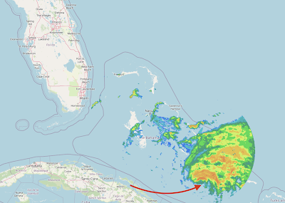
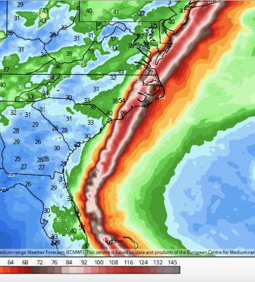
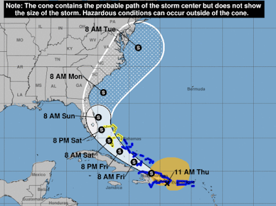
From the point of view of hurricanes, Isaias is looking rather unhealthy (weak). In fact, it may have weakened back to a strong tropical storm. The reason is there is too much wind shear and dry air on the southwest side of the storm. That is illustrated by the 2:45pm radar from the Bahamas.
The arrow points to the center of the storm. In a "healthy" hurricane there would be radar echoes all around the center. With Isaias, there is almost none.
The wind distribution from 2pm reflects this fact. The center of the storm is indicated by the +.
The satellite appearance of the storm (not shown) is still pretty ragged, meaning strengthening in the next few hours is unlikely.
As to the future, the models continue to show a storm that moves up the East Coast but the points of landfall differ. The European model, which is my go-to model in hurricane situations, has the storm making landfall in Florida and stronger than its current intensity (depicted below).
It then takes the storm back out over the Atlantic where it restrengthens a bit before making a second landfall in the Carolinas.
While I believe this is the more likely scenario, other models are farther east with no landfall in Florida at all. Thus, the hurricane watch in Florida is warranted.
Remember: with a storm like this, heavy rains are likely and flooding may result.
I'll update again later this afternoon.
The arrow points to the center of the storm. In a "healthy" hurricane there would be radar echoes all around the center. With Isaias, there is almost none.
The wind distribution from 2pm reflects this fact. The center of the storm is indicated by the +.
![]() |
click to enlarge |
As to the future, the models continue to show a storm that moves up the East Coast but the points of landfall differ. The European model, which is my go-to model in hurricane situations, has the storm making landfall in Florida and stronger than its current intensity (depicted below).
It then takes the storm back out over the Atlantic where it restrengthens a bit before making a second landfall in the Carolinas.
While I believe this is the more likely scenario, other models are farther east with no landfall in Florida at all. Thus, the hurricane watch in Florida is warranted.
Remember: with a storm like this, heavy rains are likely and flooding may result.
I'll update again later this afternoon.
11am Isaias Update: Hurricane Watch for Florida Coast
The forecast has been updated to include a hurricane watch for parts of Florida's East Coast. As indicated below, the Hurricane Center confirms the storm's winds have weakened to 75 mph and the pressure has risen to 992mb. They have nudged the forecast track a little closer to the coast (west). There is a significant threat to the Carolinas beyond the 72 hours I have depicted here.
In the next four hours we will be receiving model information that should be more reliable than what we have received so far. I plan a complete update once those models are received.
Hurricane Isaias Update: 9am Friday
Isaias is looking a bit less "healthy" on infrared satellite than it did around midnight.
The pressure has dropped slightly overnight to 990mb but the sustained winds are still 80 mph.
Here is the latest forecast from the National Hurricane Center.
Brown is the area of hurricane-force winds (75 mph or higher). Amber is the area of 40 mph or higher sustained winds. The red over the Bahamas is the hurricane warning. The yellow along the Florida coast is a tropical storm watch. The black dots with the "H" is the most likely position of the hurricane. The white (a/k/a, "the cone") is the possible position of the hurricane. Please note that it includes a landfall in Florida.
Winds are forecast to peak around 100 mph as it travels over the Bahama but weaken a bit near the Florida coast.
Frankly, the models are all over the place this morning, which is why I am only depicting the forecast through 72 hours. For reasons unknown, the NOAA Gulfstream jet, which is used to sample the atmosphere around the storm, has not been used with Isaias and is not expected to be used today, per the NHC aircraft reconnaissance schedule. That is disappointing as some of the uncertainty around this forecast might be resolved if we had those additional measurements.
If you live in Florida, I urge you -- in addition to normal hurricane preparations -- to read the American Meteorological Society's statement pertaining to sheltering with COVID.
Update: 10:10am. Satellite and hurricane hunter data both indicate the storm has weakened a bit the last few hours.
Thursday, July 30, 2020
Hurricane Isaias Midnight Update
The National Hurricane Center just issued a special update on Isaias. Below is their new forecast.
Maximum winds are 80 mph and the central pressure is 995mb. Isaias is a geographically large storm. The amber tint is the area of winds 40 mph or stronger.
Please note that while the circles with the "H" are the most likely path, the "cone" (white tint) shows a strike on eastern Florida is possible. A tropical storm watch was just issued for the Florida east coast.
I urge you to read the American Meteorological Society's statement on sheltering in the COVID era.
Hurricane Isaias 11:45pm Update
The National Hurricane Center has not changed its forecast (see below) since the 5pm update.
My thinking (two posts down) hasn't changed, either.
Update 11:30pm: Based on data from the Hurricane Hunters, it appears that Isaias has reached hurricane force or will very shortly. Hurricane watches are in effect for the Bahamas and those may be changed to a hurricane warning in the morning.
Update 11:45pm: It is official. Isaias is a hurricane with 80 mph winds. Further strengthening is forecast. A hurricane warning was just issued for the Bahamas. Pressure is 995mb.
I'll be updating tomorrow morning.
Tropical Storm Isaias Update: 5:00pm EDT
The National Hurricane Center has tweaked the forecast path of Isaias and increased its forecast intensity to hurricane force. For several meteorological reasons, I do not believe this storm is just going to parallel the coast and move out to sea without affecting land. So, if you live on the East Coast, please keep up on later forecasts.
The National Hurricane Center's path forecast (above) shows the storm missing New England -- and, that may well be the case. However, at least two, often reliable, models show the storm making a landfall in southeast New England. Please scroll down to the posting immediately below.
A special statement from the American Meteorological Society pertaining to COVID and hurricane sheltering is here. I recommend consulting it.
Darn! Tropical Storm Isaias Update
The European model (the best at forecasting hurricanes), the U.S. GFS model, and the U.S. HWRF (a hurricane model) both indicate Isaias will become a hurricane and will come close to the U.S. coast or make landfall.
This is the European's depiction. It shows the storm -- as a hurricane -- striking southeast North Carolina, moving back over the ocean and reintensifying, and then striking Long Island. The HWRF is similar.
We have a policy of not worrying about every tropical low pressure system. However, there is enough evidence now that I would recommend readers along the East Coast start paying attention to this system.
When the National Hurricane Center makes its 5pm EDT forecast, I will post it. Stay tuned.
11:30am EDT Update on Isaias
Here is the latest forecast from the National Hurricane Center.
Amber is the area of tropical storm force winds (sustained winds of 40 mph or more). At this point, the storm is not expected to make a landfall in the United States but that could change.
Want to Solve the Global Warming Problem?
As we have discussed, the solution is next-generation nuclear. I thought this thread from Twitter was worth bringing to everyone's attention. Nuclear energy -- especially next-generation nuclear -- is the safest way to generate power and, by far, the best for the environment.
Wednesday, July 29, 2020
Tropical Storm Isaias Has Formed
The white is the path the storm's center is forecast to take. However, note the storm is not symmetric. That is indicated by the tropical storm force winds (amber) being well to the northeast of the center. Right now, this is a low confidence forecast. We expect that tomorrow, we will have much more data and our confidence will improve.
Thunderstorm Developing Over Our Home
Thunderstorm developing literally above our home. It made for some unusual colors and I thought you would enjoying them. For weather fans, the cloud type is cumulonimbus.
And, another. Just as I was taking this photograph, a severe thunderstorm warning was being issued.
And, one more looking southwest. The whitish color at upper left is a rain shaft that has not yet reached the ground.
"Reclaiming My Time" - A National Disgrace
I hate publishing political items, but this is just a disgrace. It is a clip of Attorney General Barr 'testifying' before the U.S. House. The committee is chaired by a Democrat and the people in the clip are Democrats. Obviously, it was coordinated in advance ("reclaiming my time") to prevent Attorney General Barr from answering their questions.
Had it been me (and, yes, I have testified before the U.S. House), I would have walked out. Remember: we are paying their salaries. If you are interested, there is more here.
My hope is that by bringing it to peoples' attention, their insulting clown show strategy will have backfired.
Addition: A sad commentary on mutual respect in our nation. I fear the author is correct.
* I just learned this is not the first time this has occurred. It needs to stop!
Tuesday, July 28, 2020
One of the Most Amazing Tornado Videos, Ever -- A Candidate For Photogrammetry
Earlier this month, two major tornadoes occurred in Minnesota. The Basehunters (a storm chase team) posted their 4K video yesterday and there are things I believe are worth bringing to your attention.
The first is the ding to the windshield (below).
I believe that was caused by flying debris. It looks similar to a bullet strike. That is why we urge you not to take video of a tornado. If flying debris strikes you, you could be killed or seriously injured.
The second is the sound of the tornado.
I've heard many tornadoes and this is the first I've heard that sounds just like a jet engine. If you have ever been on the tarmac of a busy airport, you'll recognize the sound when the photographer steps out of the car. If you wish to watch this segment full screen, click here.
This tornado has the strongest, tightest rotation of any tornado I have personally seen or video/film that I have viewed. It would be valuable to know the windspeed of this tornado.
On April 2, 1957, a tornado struck north Dallas. A photogrammetry study was done on the video below, specifically the black and white segment (depicting flying debris) that begins when you start the clip.
In 1960, the journal Monthly Weather Review published the study (known as the "Hoecker Study") that calculated wind speeds of 170 mph in the horizontal and vertical wind speeds up to 150 mph. This would be an F-3 tornado on the original Fujita Scale. [When I tested the video last night, it worked fine. Now, it is requiring you to play it on YouTube from the beginning. The Hoecker Study portion begins at 1:00 and lasts until 1:16. Sorry for the inconvenience.]
To my knowledge, there was no research Doppler radar on this tornado. Even if there was, the circulation is so tight it probably could not be resolved.
The 4K video taken by The Basehunters has far more resolution than the Dallas film. So, I would urge that a photogrammetry study be done on this particular tornado to measure the wind speeds in the horizontal and the vertical. We might be surprised what we learn.
Blog Post: © 2020 Mike Smith Enterprises, LLC
Monday, July 27, 2020
Flood Risk For the Ozarks and Central Great Plains
Generous rains and, in many areas, needed rains fell the last 24 hours in the central Great Plains.
The forecast rainfall amounts for later this week is for very heavy rains to fall from the central Plains into the Ohio Valley.
If you live in these areas, I recommend keeping an eye on the weather as the week progresses.
The forecast rainfall amounts for later this week is for very heavy rains to fall from the central Plains into the Ohio Valley.
If you live in these areas, I recommend keeping an eye on the weather as the week progresses.
Reminder About Hurricane Coverage
We do not cover hurricanes until they are forecast to be an actionable threat for the coast. You will not see ten day hurricane forecasts here because they are often "weather porn."
I don't want to worry you until there is something to worry about.
Sunday, July 26, 2020
Hurricane Douglas: Approaching Hawaii
Here is Douglas at 1:30pm Central Time (8:30am Hawaii time).
It's intensity is 85 mph and is expected to pass over Maui and, later, Oahu by tonight. It is rather unusual for a hurricane to strike the island from the east. On the rare occasion Hawaii has a hurricane it is usually during an El Nino and it comes from the south.
Saturday, July 25, 2020
Hurricane Hanna Update
Update: 10:15am. Maximum sustained winds are 80 mph. I believe the forecast (below) of 85 mph winds, with gusts to near 100 mph, at landfall is still valid. The strongest winds will occur in coastal areas from Port Aransas and Corpus Christi south to near Baffin Bay. Storm surge will be in the 5' to 6' range with waves to 15 feet. Tornadoes are possible.
---------
Here is the radar image of Hurricane Hanna as of 8:30am.
As of 8am, the National Hurricane Center says Hanna's winds are 75 mph. There are indications it is still strengthening and may have winds to 85 mph upon landfall.
---------
Here is the radar image of Hurricane Hanna as of 8:30am.
As of 8am, the National Hurricane Center says Hanna's winds are 75 mph. There are indications it is still strengthening and may have winds to 85 mph upon landfall.
Weather Forecast Accuracy Has Deteriorated As a Result of Fewer Flights
We receive wind, temperature and humidity data from aircraft in flight. Fewer flights = less data. The details are here.
Friday, July 24, 2020
Hurricane Warnings: Texas and Hawaii
Let's start with Texas.
Hanah is forecast to reach 75 mph winds before making landfall Saturday afternoon. The bigger problem will be excessive rainfall rather than the storm's winds. More than seven inches of rain will fall on south Texas. In some places totals will touch twelve inches. Prepare for flooding.
The above map is total rainfall for the next seven days. By Monday, the humidity from Hanah will rotate around a high pressure system into the central Great Plains. That moisture will interact with a low pressure system in the upper atmosphere to produce welcome rains in the region.
Hawaii
Hurricane Douglas is forecast to move across the islands Sunday bringing strong tropical storm or
marginal hurricane winds and flash flooding, the latter possibly severe. Hurricane watches are out for the Island of Hawaii, Maui and Lani.
Thursday, July 23, 2020
Please Don't Do This!
There was a tornado outside Calgary today and a hailstorm in town.
An underpass creates a "wind tunnel" that makes tornado-force winds even stronger and, thus, more dangerous. Whatever you do, do not stop under an underpass for a tornado or hailstorm.
Two Epidemiologists Discuss Coronavirus
Highlights:
- There is no reliable evidence masks work outside of a healthcare environment. They bring up an interesting point that as the mask moistens, it makes the situation worse.
- High humidity destablizes the virus (makes it less lethal).
- Cooler, less humid weather makes it
lessmore transmissible on surfaces. - There are many unknowns with regard to the transmission of this virus that are not understood and probably will not be understood until the autumn and winter.
- The chance of deaths in children is extremely low -- less than one in a million.
As I was working on this post late Wednesday afternoon, I was watching the Royals v Cardinals. I have a couple of comments regarding this photo.
There is literally zero chance of catching any illness in the open outdoors by yourself. None. But, if you want to wear a mask, wear it properly. Note that his nostrils are not covered.
Of course, if there is a law that says you have to wear a mask, wear a mask. I wear a mask indoors and surgical gloves as I believe the combination may be helpful even though there is considerable uncertainty.
However, there is simply no evidence that you can catch any disease in the unconstrained outdoors (e.g., riding a bicycle, jogging, playing baseball). I worry about heat exhaustion with masks in very hot weather.
Wednesday, July 22, 2020
Finally: Straight Talk About Coronavirus
Government's response to coronavirus has been a tragedy. A realistic way forward is here.
Agree with this 100%.
Tuesday, July 21, 2020
Happy 150th Birthday, Wichita!
Today is the 150th birthday of the Aviation Capital of the World. May the next 150 be as productive and innovative.
Monday, July 20, 2020
Sunday, July 19, 2020
Sunday Fun: Helen Hunt Answers Questions About "Twister"
Amidst rumors about a re-make, here are your questions answered about the original.
Saturday, July 18, 2020
Stalking Horse: "Tax Me More"
You see these from Bill Gates and others from time to time:
The true aim of these is to attempt to build momentum for tax increases on all of us -- after they have made more than enough to live a life of luxury (remember, previous earnings would not be taxed in a future tax increase).
On the outside chance they are sincere, I'll help them out. Click here.
They can write a check for any amount they wish. There is absolutely no need to tax the rest of us if they believe they are undertaxed.
Friday, July 17, 2020
In Defense of Liberty and Free Enterprise
The United States for much of its history was the freest nation on earth. Sadly, that is no longer true. We need to regain our respect for the Constitution and Declaration of Independence and the principles they expound.
For our nation and its people to prosper in harmony there are five essential elements:
- Individual liberty with the smallest government possible (history has shown the bigger the government, the bigger its temptation to meddle)
- Free enterprise
- The rule of law
- Judeo-Christian values (note: I'm not saying everyone should be a Christian or a Jew, I'm saying those values are essential)
- All underpinned by a great education for everyone
From what I can tell, today's educational system often does not adequately explain the reasons free enterprise (a/k/a, capitalism) is -- by far -- the best way to guarantee prosperity for everyone. The late Dr. Milton Friedman was an economist who had the gift of explaining economic concepts in an engaging way.
Before there was Oprah! there was The Phil Donahue Show. Phil was a rather liberal host who would, over the course of an hour, bring on guests of all stripes and would allow the audience to question them. This 45-minute program (no commercials) is a terrific course in economics that I would recommend to your high school student. To whet your appetite, I have cued the clip up to where Dr. Friedman explains to Phil that, within reason, "greed" and pursuing one's own self-interest leads to far better outcomes than bureaucrats running an economy from inside the Beltway.
If you appreciate his answer about greed, go back to the beginning of the program and watch the entire 45 minutes. I'm sure students, especially, will get a great of benefit, even if you don't agree with everything he says.
Thursday, July 16, 2020
This Could Be Bigger Than the Walkman
In 1979, Sony revolutionized personal entertainment with the Walkman. It was nearly as big as the iPhone. For joggers, sports fans and outdoor workers, this could be huge.
People can raise or lower the temperature of the air surrounding their torso with Sony's new device.
Wednesday, July 15, 2020
Mid-July Rainfall Update
Heavy rains fell overnight in northwest Missouri (up to 7 inches) and southwest Kansas (up to 5 inches). The map represents rainfall to 7am today.
For the last two weeks, rainfalls have been below average in most of Iowa and above average in central Kansas.
Below is forecast rainfall for the next 36 hours (7am Wednesday to 7pm Thursday).
Tuesday, July 14, 2020
July's Required Reading
Jason Whitlock's column about America, Christianity and journalism is this month's required reading.
And, a short piece pertaining to the corruption of science due to 'social justice' concerns.
Finally, because we support free speech and reject the "cancel culture," Kathleen just returned from the grocery store.
And, a short piece pertaining to the corruption of science due to 'social justice' concerns.
Finally, because we support free speech and reject the "cancel culture," Kathleen just returned from the grocery store.
Monday, July 13, 2020
Today's Severe Weather Outlook
There is an area of tornado risk (brown) in Minnesota.
The bigger threat, overall, is over the High Plains.
In the orange area, hail larger than 2" and wind gusts of 75+ mph are forecast. Please prepare accordingly.
The bigger threat, overall, is over the High Plains.
In the orange area, hail larger than 2" and wind gusts of 75+ mph are forecast. Please prepare accordingly.
Subscribe to:
Posts (Atom)