
Darn! Tropical Storm Isaias Update
The European model (the best at forecasting hurricanes), the U.S. GFS model, and the U.S. HWRF (a hurricane model) both indicate Isaias will become a hurricane and will come close to the U.S. coast or make landfall.
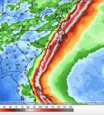

This is the European's depiction. It shows the storm -- as a hurricane -- striking southeast North Carolina, moving back over the ocean and reintensifying, and then striking Long Island. The HWRF is similar.
We have a policy of not worrying about every tropical low pressure system. However, there is enough evidence now that I would recommend readers along the East Coast start paying attention to this system.
When the National Hurricane Center makes its 5pm EDT forecast, I will post it. Stay tuned.


Comments
Post a Comment