Posts

Showing posts with the label Isaias

Hurricane Isaias Update, 4:45pm CDT

Image
The map below shows: the path of the eye of the storm, white,   the hurricane warning area, red,  tropical storm warning and hurricane, striped, tropical storm warning, blue,  tropical storm watch, yellow The forecast for Isaias is essentially unchanged. It is expected to be Cat 1 at landfall.  Dangerous storm surge is the greatest threat from Isaias. There will also be flash flooding inland and, along and to the east of the eye, the potential for tornadoes. 

4pm Isaias Update

Image
Pressures are falling rapidly which will likely lead to rapid intensification. In the last six hours, the pressure has dropped from 1000 to 994 millibars. Its maximum sustained wind is already 65 mph, just 10 mph short of hurricane force. If Isaias reaches hurricane force, as it almost certainly will, it would be the first hurricane in the Atlantic Ocean Basin in 2026.  The storm is forecast to be a Cat 1 or weak Cat 2 in terms of wind speed when it makes landfall.  Storm Surge Forecast Seven feet is a major storm surge!  Please observe local information regarding evacuations.  Flash Flood Risk This is a flash flood forecast for the next five days. Please make plans to evacuate if you live in a low-lying or flood-prone area, especially if you reside in the red area. Tornadoes I believe there will be a major tornado threat with Isaias but it is too soon to make a specific forecast. 

(Update, 12:15pm) Isaias Update: Hurricane Watch Issued

Image
12:15pm. Hurricane Hunter aircraft shows the pressure has dropped six millibars in 2 hours which will likely pave the way for rapid intensification.  -- original post, still valid --  A hurricane and storm surge watch is in effect for the pink are on the map. A tropical storm watch is in effect for the area in yellow. Peak winds are forecast to be 110 mph while it is over the Gulf and somewhat less strong when it makes landfall. A major storm surge is forecast. I will update this afternoon. 

Hurricane Overview October 5 at 5:45pm

Image
There are three hurricanes that are going to affect the United States in the next ten days or so. There are three important weather systems that will affect the U.S. Lower 48 during the next 3 to 15 days. The above map is a rough overview. Note: Isaias may come inland farther west than shown on this map.  Above represents the forecast rain amounts for the next five days. Isaias is along the Gulf Coast and pretty well speaks for itself.  Hurricane #1 will move from the Pacific into Baja and will spread moderate to heavy rain over the Intermountain Region from days 3 to 9. Flooding possible in spots.  Tropical Storm or Hurricane #2. It will move into the body of Mexico and spread rain, possibly heavy, over Texas (Day 5 to 9) and the south central United States. Rain over Texas is badly needed and relatively little flooding is expected at this point.  As of 5:30pm, Isaias is developing in the Bay of Campeche in the far southwest Gulf.  Here is the preliminary forec...

Hurricane Isaias: Forecast of Inland Winds Has Been Increased

Image
This is very serious if it turns out to be accurate.  This increase in inland winds is plausible because the Hurricane Hunters just found surface winds of 86 mph in the storm, which is higher than was forecast even a few hours ago.  If this forecast is correct there will be major power failures, some lasting a week or more in duration. While it is too late on the coast, the people on this map still have time to prepare. Please do so immediately.  New tornado watch just issued.

Power Failures Likely As Isaias Moves Through the Middle Atlantic and Northeast States

Image
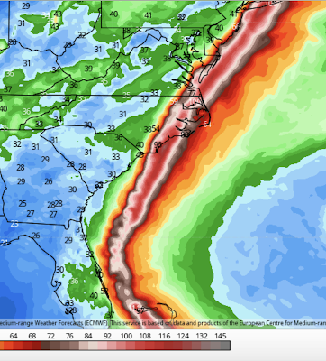
While Hurricane/Tropical Storm Isaias "underperformed" many peoples' perceptions in Florida (I'll write an post on that topic later today), it will be strong enough to down tree limbs along and to the east of its path through the Middle Atlantic and Northeast states. Here are the current forecast peak wind gusts in the Middle Atlantic region. And, the forecast peak gusts in the Northeast. So, in the areas of orange, red and brown, prepare for power failures. In some cases, the power failures could last for a few days.  There are also flash flood watches out for much of the region. In addition to power failures, flash floods and tree damage, there is a likelihood of tornadoes in the area in brown late today and tonight. Please prepare accordingly. Here is the radar view of the storm as of 1:26pm.

Tropical Storm Isaias Update, 6:30pm Saturday

Image
Isaias is making a mighty try at restrengthening as indicates by the lightning (+). Lightning usually means a strengthening tropical system but this one is dealing with so much dry air, it will be a surprise if it can significantly strengthen. In any case, while you should not yet discontinue precautions, I will be surprised if hurricane strength winds (sustained winds of 75 mph or stronger) occur on the Florida coast. The storm has slowed considerably and seems to be moving more toward the NNW rather than northwest. I'll update at least once again this evening. Reminder: You will find additional information from me at Twitter @usweatherexpert . 

Hurricane Isaias Update: 6:30pm Friday

Image
Note: as of 11pm EDT, the intensification mentioned below reversed itself. Please see the posting immediately above for the latest information.  A few quick points: The barometric pressure has dropped six millibars to 985mb in the last three hours. The eye of the storm as of 6:25pm is looking more impressive on radar. As with the drop in pressure, this is a sign of strengthening. Compare it to the depiction of the eye in the posting below. Note the yellow (stronger radar echo) is now a full 360° around the eye. So, the forecast of strengthening appears to be on track. Here is AccuWeather's forecasts of the effects of Isaias on Florida. These look reasonable to me. West Palm Beach and Ft. Lauderdale may have higher winds than Miami. Finally, the American Meteorological Society tweaked its advice statement on hurricane sheltering in the COVID era this afternoon. The revised statement is here . I recommend you read it.

3pm Update on Hurricane Isaias

Image
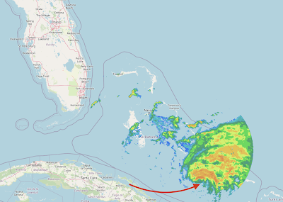
From the point of view of hurricanes, Isaias is looking rather unhealthy (weak). In fact, it may have weakened back to a strong tropical storm. The reason is there is too much wind shear and dry air on the southwest side of the storm. That is illustrated by the 2:45pm radar from the Bahamas. The arrow points to the center of the storm. In a "healthy" hurricane there would be radar echoes all around the center. With Isaias, there is almost none. The wind distribution from 2pm reflects this fact. The center of the storm is indicated by the +. click to enlarge The satellite appearance of the storm (not shown) is still pretty ragged, meaning strengthening in the next few hours is unlikely. As to the future, the models continue to show a storm that moves up the East Coast but the points of landfall differ. The European model, which is my go-to model in hurricane situations, has the storm making landfall in Florida and stronger than its current intensity (depicted below...

11am Isaias Update: Hurricane Watch for Florida Coast

Image
The forecast has been updated to include a hurricane watch for parts of Florida's East Coast. As indicated below, the Hurricane Center confirms the storm's winds have weakened to 75 mph and the pressure has risen to 992mb. They have nudged the forecast track a little closer to the coast (west). There is a significant threat to the Carolinas beyond the 72 hours I have depicted here. In the next four hours we will be receiving model information that should be more reliable than what we have received so far. I plan a complete update once those models are received.

Hurricane Isaias Update: 9am Friday

Image
Isaias is looking a bit less "healthy" on infrared satellite than it did around midnight. The pressure has dropped slightly overnight to 990mb but the sustained winds are still 80 mph.  Here is the latest forecast from the National Hurricane Center. Brown is the area of hurricane-force winds (75 mph or higher). Amber is the area of 40 mph or higher sustained winds. The red over the Bahamas is the hurricane warning. The yellow along the Florida coast is a tropical storm watch. The black dots with the "H" is the most likely position of the hurricane. The white (a/k/a, "the cone") is the possible position of the hurricane. Please note that it includes a landfall in Florida.  Winds are forecast to peak around 100 mph as it travels over the Bahama but weaken a bit near the Florida coast.  Frankly, the models are all over the place this morning, which is why I am only depicting the forecast through 72 hours. For reasons unknown, the NOAA Gulf...

Hurricane Isaias Midnight Update

Image
The National Hurricane Center just issued a special update on Isaias. Below is their new forecast. Maximum winds are 80 mph and the central pressure is 995mb. Isaias is a geographically large storm. The amber tint is the area of winds 40 mph or stronger. Please note that while the circles with the "H" are the most likely path, the "cone" (white tint) shows a strike on eastern Florida is possible. A tropical storm watch was just issued for the Florida east coast. I  urge you to read the American Meteorological Society's statement on sheltering in the COVID era .

Hurricane Isaias 11:45pm Update

The National Hurricane Center has not changed its forecast (see below) since the 5pm update. My thinking (two posts down) hasn't changed, either. Update 11:30pm: Based on data from the Hurricane Hunters, it appears that Isaias has reached hurricane force or will very shortly. Hurricane watches are in effect for the Bahamas and those may be changed to a hurricane warning in the morning.   Update 11:45pm: It is official. Isaias is a hurricane with 80 mph winds. Further strengthening is forecast. A hurricane warning  was just issued for the Bahamas. Pressure is 995mb.  I'll be updating tomorrow morning.

Tropical Storm Isaias Update: 5:00pm EDT

Image
The National Hurricane Center has tweaked the forecast path of Isaias and increased its forecast intensity to hurricane force. For several meteorological reasons, I do not believe this storm is just going to parallel the coast and move out to sea without affecting land. So, if you live on the East Coast, please keep up on later forecasts. The National Hurricane Center's path forecast (above) shows the storm missing New England -- and, that may well be the case. However, at least two, often reliable, models show the storm making a landfall in southeast New England. Please scroll down to the posting immediately below. A special statement from the American Meteorological Society pertaining to COVID and hurricane sheltering is here . I recommend consulting it. 

Darn! Tropical Storm Isaias Update

Image
The European model (the best at forecasting hurricanes), the U.S. GFS model, and the U.S. HWRF (a hurricane model) both indicate Isaias will become a hurricane and will come close to the U.S. coast or make landfall.  This is the European's depiction. It shows the storm -- as a hurricane -- striking southeast North Carolina, moving back over the ocean and reintensifying, and then striking Long Island. The HWRF is similar.  We have a policy of not worrying about every tropical low pressure system. However, there is enough evidence now that I would recommend readers along the East Coast start paying attention to this system.  When the National Hurricane Center makes its 5pm EDT forecast, I will post it. Stay tuned.