
3pm Update on Hurricane Isaias
From the point of view of hurricanes, Isaias is looking rather unhealthy (weak). In fact, it may have weakened back to a strong tropical storm. The reason is there is too much wind shear and dry air on the southwest side of the storm. That is illustrated by the 2:45pm radar from the Bahamas.
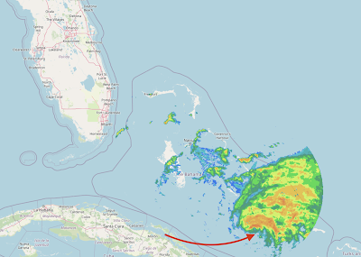 The arrow points to the center of the storm. In a "healthy" hurricane there would be radar echoes all around the center. With Isaias, there is almost none.
The wind distribution from 2pm reflects this fact. The center of the storm is indicated by the +.
The satellite appearance of the storm (not shown) is still pretty ragged, meaning strengthening in the next few hours is unlikely.
As to the future, the models continue to show a storm that moves up the East Coast but the points of landfall differ. The European model, which is my go-to model in hurricane situations, has the storm making landfall in Florida and stronger than its current intensity (depicted below).

It then takes the storm back out over the Atlantic where it restrengthens a bit before making a second landfall in the Carolinas.
 While I believe this is the more likely scenario, other models are farther east with no landfall in Florida at all. Thus, the hurricane watch in Florida is warranted.
Remember: with a storm like this, heavy rains are likely and flooding may result.
I'll update again later this afternoon.

The wind distribution from 2pm reflects this fact. The center of the storm is indicated by the +.
 |
| click to enlarge |
As to the future, the models continue to show a storm that moves up the East Coast but the points of landfall differ. The European model, which is my go-to model in hurricane situations, has the storm making landfall in Florida and stronger than its current intensity (depicted below).

It then takes the storm back out over the Atlantic where it restrengthens a bit before making a second landfall in the Carolinas.

Remember: with a storm like this, heavy rains are likely and flooding may result.
I'll update again later this afternoon.


Comments
Post a Comment