Posts

Showing posts from October, 2017

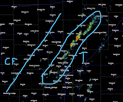
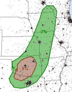
Holiday Book Idea: "Warnings"

Image
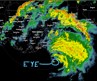
Recent review at Goodreads. Ken Heard   rated it  it was amazing I was surprised to learn that the Weather Bureau (now the National Weather Service) refused to issue tornado warnings as late as the 1950s so as not to scare people unnecessarily. That seems ridiculous today with constant live reports from tv weathermen, upgraded polarization Dopplar radars, satellite imagery that can pinpoint a tornado's thought process and more. But that was the case, and Mike Smith was on the forefront of changing that practice. His book is an excellent history of tornadoes and hurricanes and the mindset that accompanied them in those days. The book is almost three-fold. First, he describes with excellent clarity the actual storms. He also throws in science behind the storms, what causes them, et al. And he includes his personal memoirs on them. Like most meteorologists, Smith got involved in weather forecasting because of a storm. He saw a devastating Kansas tornado that sparked his

Why a Warm Climate is Better Than Cold

Recent discoveries of human skeletons confirm the revelation of the colony’s president, George Percy, that they also resorted to cannibalism: “Some adventuringe to seeke releife in the woods, dyed as they sought it, and weare eaten by others who found them dead.” When one man confessed under torture to having murdered and eaten his wife, Percy ordered his execution. From a New York Times'   review of "A Cold Welcome: The Little Ice Age and Europe's Encounter with North America." I assure you: if the climate cooled significantly, there are be mass starvation (due to shorter growing seasons) across the world. The people who worry about global warming should really be more careful what they wish for.

Puerto Rico Is Burning Its Dead, And We May Never Know How Many People The Hurricane Really Killed

Image
Buzzfeed  has a sickening story that seems to confirm what many meteorologists believe: the death toll in Puerto Rico is much higher than the official numbers. Nearly ninety years ago, a hurricane in Florida killed so many the dead were buried in mass graves. I had hoped America had gotten past the era where we could properly bury people from weather-related disasters.

Major Storm: Northeast United States and Southeast Canada

Image
Extreme winds are likely. With a severe flash flood threat. The red "moderate" is a serious threat. Please remember: Drive slowly as downed trees are likely and turn around, don't drown.  Never drive into a flooded area.

Sunday Fun: Wichita State's Run for a National Championship

From USAToday . Everyone in town is super excited about the upcoming college basketball season.

Saturday Fun: Can You Guess Her Halloween Costume??

Image
This actress is in Made in America.  Can you guess what Sarah is "being" in her Halloween costume? If not, click here . If you want to go to a party or trick-or-treat in the same costume as the original, go here . I suspect the original cost less than the variant Sarah Wright is wearing.

Serious Flash Flood Risk

Image
This forecast is valid from 8am Sunday through 8am Monday. The areas in yellow and, especially, in red have a serious risk of flash flooding. Please remember: Turn around, don't drown!

Why Climate Scientists Need to Understand Basic Meteorology

Image
Over the summer, I had a rather lengthy discussion with an amateur climate scientist who insisted there was no reason that climate scientists needed to know basic meteorology. I recalled that conversation when I read this  paper from Nature Communications. The paper tells us: There was accelerated melting of glaciers when distant volcanoes erupted. The soot could be carried considerable distances by upper atmospheric winds. Because the glaciers were far away, the soot from those volcanoes could fall out of the atmosphere and onto the surface of glaciers.  That soot darkened the bright while snow and ice cover of the glacier. Darkening a field of snow or ice will cause rapid melting even if temperatures stay the same.  I don't mean to be harsh but any third year meteorology student would have know that darkening a snow cover rapidly accelerates melting. From this blog on December 5, 2009: So, if temperatures in the Arctic are not warmer than normal during the melt seaso

Have You Made a Donation to Puerto Rico Relief?

The official death toll has risen to 51 due to two deaths from leptospirosis. I was sickened when I learned the definition of that term . No human being -- let alone Americans -- should become sickened in that way. Regardless of what the government may, or may not, be doing, there is always an important role for private charity. Please make a donation as soon as possible. If you already have, God bless you.

"This Was Their Finest Hour"

Image
At about this time five years ago Hurricane Sandy made landfall in New Jersey. It was one of the most important forecasts in the history of meteorology and it saved thousands of lives.

Tornado Watch Extended Northeast: Virginia and North Carolina

Image
Damaging tornadoes have already occurred today. Please keep up on the weather in the areas in this new tornado watch. See existing tornado watch below.

Tornado Watch Georgia and in the Carolinas

Image
Please keep up on the weather if you are in the red outlined areas.

Tornado Risk in the Carolinas

Image
The brown area is where there is a significant risk of tornadoes later today. This includes Columbia, Charlotte, Charleston, and Wilmington. Please keep up on the weather in these areas later today.

What Is The Situation in Puerto Rico Now?

An excellent article from the Miami Herald  and the Center for Investigative Journalism, here . If you can donate to Puerto Rico's recovery, please do so.

The Issues With Flood Maps

Great article from Bloomberg, here .

Sunday Fun: Kansas' Farmer Derek at It Again

Image
This time, a Taylor Swift parody.

Heads Up: Oklahoma

Image
Frequent readers know I have a policy of publicly validating each of my forecasts. Below is my forecast of the tornado risk in Oklahoma (below that is the NWS's).  Here is a map that shows, as of 9:40am Sunday, the tornado locations in red. There are multiple reports (hard to see in black) of hail up to 3" in diameter in southwest Oklahoma. I would rate this to be a "good" quality forecast.  -- Original Posting --- Here is the weather satellite image as of 2:30pm CDT. Note: there is a severe thunderstorm watch in effect in Kansas and Missouri (see below). I've outlined the area where there is a threat of giant hail and a couple of tornadoes in red. Please keep an eye on the weather in this area the rest of the afternoon. Addition: Tornado watch for most of the western half of Oklahoma (not including the Panhandle): It includes Oklahoma City, Enid and Wichita Falls.

Severe Thunderstorm Watch: Kansas and Missouri

Image
Normally, I don't post severe thunderstorm watches but there is a chance of a tornado in the area and there are many outdoor activities in the region.

Heads Up: Eastern 2/5th's of Kansas

Image
Here is the radar from 1:11pm CDT. CF = Cold Front. T = area of thunderstorms. I've circled the areas where thunderstorms are now developing. They are moving northeast and pose a lightning risk. I expect more thunderstorms to develop along and ahead of the cold front the rest of the afternoon. Remember, When Thunder Roars, Go Indoors! There is a good chance that some of the Kansas storms will produce hail and strong winds. In south central Kansas, large hail and damaging winds are possible. There is an outside chance of a tornado. Please keep up with the weather the rest of the afternoon.

Get the AccuWeather App!

If you do not have the AccuWeather App, get it today. Given the storm risk, the fact that it will follow you and warn you -- no matter where you are -- of dangerous weather conditions. All you have to do is click here . When it asks you if you to allow location services, turn them on. That way, it can warn you at the football stadium, work or home.

Tornado and Giant Hail Risk Later Today

Image
This is extremely important if you plan to attend a football game in the Great Plains this afternoon or evening. Tornado Risk The significant risk is the brown area. It does not mean a tornado will occur but, to give you some perspective, it is a great enough risk that a tornado watch  will likely be issued this afternoon. Of course, a tornado warning  will be issued if it is time to take cover. Giant Hail The significant risk of 1" or larger hail is the yellow area. The red is an enhanced risk of 1" hail. The hatched area is where hail larger than 2" is forecast to fall. It is important that you have a plan. If your AccuWeather App tells you a warning has been issued or if the stadium authorities give instructions, follow them. If the stadium announcer does not give you instructions after receiving a warning for severe thunderstorms or tornadoes, you are probably better off in your car than you are in your seat. This is especially true if lightning is a thre

Brilliant Quote From the Late Steve Jobs

I had never heard this until this morning: It doesn't make sense to hire  smart people  and tell them what to do; we hire smart people so they can tell us what to do.

30 Year Anniversary of "Black Monday"

Image
We interrupt our normal science-based blogging.  Today is the 30th anniversary of the Black Monday crash of 1987, when the Dow lost more than 22% of its value in a single day. The biggest one-day crash in history. These days, too many, especially those under the age of 30, don't seem to understand the critical nature of beginning to invest at an early age. The magic of compound interest can make you very comfortable when you retire but only if you begin when you are young. I would like to demonstrate the value of the above advice with excerpts from that Friday's Wall $treet Week with Louis Rukeyser. When everyone else was in full panic mode, Lou was calm and cool. Lou had three of titans of investing as his guests on his show. I was always so impressed with Sir John Templeton. Some called him the greatest investor of the 20th Century. As was usually the case, the late Sir John was absolutely correct. In 1987, there were no laptop computers, no smartphones, no iPo

What It Is Like to Be Hit By Lightning

An interesting story from The Washington Post . 

Yes, We Are All Americans

Houston, after Harvey : As I walked the floor (which I estimated to be the size of 10 to 12 football fields), I found that many people just needed someone to listen to their stories and maybe hold their hands.  I saw families and single mothers with two, four, or even six children, including newborns.  I spoke to people who had been separated from families or had no one else in the world.  I prayed with elderly and handicapped people and became friends with an elderly man with no legs in a wheelchair who always had a smile for me.  I procured small stuffed animals and toys for dozens of small children and babies.  I was rewarded with tiny smiles and blessed to hold little hands. I have been amazed by the courage and hope and faith in God displayed by these victims who did not behave like "victims."  They kept up their spirits and told their stories and, in very profound ways, ministered to me and other volunteers.  Yes, there was some tension and tribulation, and there w

"But I Kind of Got Sick of Calculus Classes"

Many people who want to be meteorologists get discouraged in college because of the extraordinarily difficult curricula. One of them is the director of this year's World Series broadcasts . Guess things worked out okay for him!

Happy 55th Birthday, AccuWeather!

Image
With all of the recent storms and adverse weather, I didn't want to let this important occasion pass. AccuWeather just celebrated its 55th anniversary. Below is our corporate headquarters in State College, Pennsylvania.  I have the pleasure of working in AccuWeather's extreme weather center in Wichita where we take care of most of our business-to-business clients. Here is a video with our founder, Dr. Joel Myers, recounting the history of our company I'm very proud to be part of this organization that has saved lives and property for so many.

Effectiveness of Building Codes and Storms

We have found that for different samples of our loss data, the benefit-cost ratios  range  from a low of 2.67 to a high of 7.93. In other words, comparing the increased construction cost to the expected reduction in windstorm damage across the life of the home  shows  anywhere from $2 to $8 in expected damage reduction—the benefit—for every dollar of increased cost. The entire paper is here .

This Week's Rainfall

Image

Sunday Fun: "Afar" Visits Wichita

There’s a sense of pride and a deep understanding of the place that’s incredibly alluring to me as a traveler. It’s something that’s hard to find in bigger markets. Come and find out for yourself what made Wichita so alluring to " Afar ."

Issue: Wildfire Warnings Were Not Sent to Residents

Image
Note: Please see additional information below. A disturbing report from The Washington Post  regarding the lack of warning for the tragic wildfires in California. "Panic"? That is what we heard 60 years ago with regard to tornado warnings . The result, in part, of not warning of the wildfires? In Lake County, officials took a different course. And, the happy result? No deaths have been reported in Lake County. The death toll of 36, with dozens missing, is one of the worst fire fatality death tolls in decades. Warnings can be successfully issued for wildfires as Lake County demonstrated with this round of catastrophic fires. But, authorities outside of the areas where tornado and hurricane warnings are routinely issued, still seem to have a mid-20th Century when it comes to their reluctance to issue warnings of natural hazards. That needs to change . ADDITIONAL INFORMATION: This is from my friend, Lanny Dean, who was covering the wildfires in Californi

A Touching Story About Two Survivors of the California Wildfires

A couple survived by spending hours in a neighbor's swimming pool . They lost everything except each other. A touching story and an example of great journalism.

Preventing Vicious Wildfire Damage?!

Image
Courtesy: AccuWeather Dr. Cliff Mass, a meteorology professor at the University of Washington, has a fascinating idea to prevent terrible wildfires like the ones of the last few days: use precision short-term weather forecast models to identify areas where extreme winds will occur and then kill the power before sparks or a fallen line can start a fire. There is precedent. When violent tornadoes are moving through an urban area, the power is cut in the area of the tornado and, on occasion, just ahead of the tornado's path. This prevents fires in the damaged areas. Power was proactively cut in the path of Hurricane Irma if media reports were correct. Of course, there are pro's and con's to Cliff's idea. It is certainly worth considering.

The Misery in Puerto Rico Worsens

The Washington Post   has the latest on the flash floods and mudslides in Puerto Rico. I cannot emphasize enough how important it is to donate to the relief efforts. These are our fellow citizens.  Update: There are many questions about to whom donations hold be directed. I checked with my friend, Puerto Rican (and meteorologist) John Morales, and he recommends this group: https://www.youcaring.com/familiesandkidsdevastatedbyhurricanemaria-956568 Please send some money their way. Any amount would be helpful! Thanks, and God bless you for doing so.

Barry Myers Nominated to Be Head of the U.S. National Oceanic and Atmospheric Administration

The CEO of AccuWeather and my friend, Barry Myers, has been nominated by President Trump to be the head of NOAA. Barry will do an outstanding job leading NOAA to an even higher level of service to the American people. UPDATE: AccuWeather's press release, which includes some of Barry's qualifications, is here .

Validating Yesterday's Forecast

I made a forecast of severe weather over southeast Kansas and northeast Oklahoma yesterday. It was terrible. But, I make it a point to publicly validate my forecasts, so here goes.  Tornado potential: Elevated. One to three possible.   No tornadoes occurred.  Hail potential: High, up to 2" in diameter   No large hail was reported.  Damaging thunderstorm winds: Elevated, up to 60 mph   None before 7pm (it occurred after). Lightning risk: High in Kansas, very high in Oklahoma Three people hit by lightning near Matfield Green, Kansas.  Unfortunately, the lightning forecast was correct and it resulted in three injuries. The rest of the forecast was very wrong and I apologize for making a poor forecast. 

Amazing Fire Photography Essay

Image
With the horrors of the fires in progress in California, there can be a beautiful side to wildfires. National Geographic  has the story and the photography.

An Overview on the Hurricane Risk, Long Term

Ross McKittrick has written an article about the long-term hurricane risk in the United States. With another storm threatening, I recommend it.

Heads Up: Southeast Kansas and Northeast Oklahoma

Image
The NWS has issued a severe thunderstorm watch for about the same geographic area. ____________________Original Posting Below_____________________ Heads up in the red outlined area: Tornado potential: Elevated. One to three possible.  Hail potential: High, up to 2" in diameter Damaging thunderstorm winds: Elevated, up to 60 mph Lightning risk: High in Kansas, very high in Oklahoma From now until 7pm. 

Weather Science's Value is Finally Being Appreciated

Article #1: What seemed impossible decades ago is now true: When they make landfall, big hurricanes aren’t killing many people. Only truly exceptional storms — or more likely exceptionally poor preparedness — spawn large numbers of fatalities in the United States when one comes ashore. The big death tolls are now from flooding, often days later. The full article is here . And, if you want to learn more about how meteorologists save so many lives, there is another article here .

Sunday Fun: The Worst Phishing Letter Ever

Image
Because of Hurricane Nate, I didn't want to do the Sunday Fun feature this morning. Now that it looks like the damage was not too bad, I thought I'd do it to give everyone a laugh before they start their work week. Here is the worst phishing letter ever:

We Were Fans of Komodo Dragons Before They Were Fashionable

Image
Kathleen and I are huge fans of the wacky 1990 movie The Freshman.  In spite of Marlon Brando reprising his role as The Godfather, it did not fill theaters (today, it has a 92% "fresh" rating from Rotten Tomatoes). Since it is available from many video sources, it is a movie I highly recommend. The star of the movie was not Brando or a young Matthew Broderick. It was a Komodo Dragon . Now, we learn that the dragon may be the key to a crucial new source of antibiotics . You never know from where the next advance in science will come. Science is never "settled."

Speaking of Storms Over Water...

...an interesting article about a sea-faring radar .

Saturday 5:10pm Hurricane Nate Update

Image
Here is the storm at 5:07pm CDT: The storm is moving slightly west of due north. I expect it to make landfall on the Mississippi coast this evening. Please see the information below. This is the last forecast update on Nate.

Two-Week Rainfall in Winter Wheat Belt

Image
After last night's Great Plains thunderstorms, I've updated the winter wheat two-week rainfall map. Just about all of the production area has received significant rains during that period of time.

Saturday 12:40pm Hurricane Nate Update

Image
The National Hurricane Center now expects sustained winds of 105mph (with higher gusts) along the coast at landfall this evening. 12:30pm satellite image

Dangerous Hurricane Nate Approaches the Coast

Image
Nate is now expected to be a Category 2 hurricane at landfall this evening.  Near and east the point of landfall, there will be a  storm surge of 7 to 12 feet which  will cause  life-threatening flooding. Please make sure friends and relatives are aware the storm  will be  somewhat stronger than originally forecast.  If you live in New Orleans/southeast Louisiana or the Mississippi or Alabama coasts, I urge you in the strongest possible way  to check the list below and make sure you are ready for the storm. After about 4pm, the weather will deteriorate quickly and it will be too late.  Here is the updated forecast map. The "H" at the tip of Louisiana is for 7pm.  The 10am advisory had sustained winds of 90 mph. I expect sustained winds of at least 100 mph with gusts to 110 mph at landfall. Based on the latest satellite images, Nate is still strengthening. 10:02am satellite image is below. If you in southeast Louisiana (including New Orleans), th

Hurricane Nate Is Hours Away

Image
Hurricane Nate Will Make Landfall This Evening Nate is forecast to have sustained winds around 90 mph with gusts to around 100 mph near and east of where the center makes landfall. Because we do not have full certainty where that is, the red areas should complete their precautions immediately.  The most likely scenario is for the center of the storm to make landfall on the Mississippi coast with damaging winds from the center to the Florida-Alabama border. This area will experience a life-threatening storm surge. Please prepare accordingly!

I've Been Concerned About This: Drug Shortages

Image
Many drugs are manufactured on Puerto Rico; some nowhere else. The New York Times  has picked up the story . An excerpt: Not good.

Nate is Strengthening

Image
Nate has sustained winds of 70 mph, just 5 mph below hurricane strength. Additional strengthening is likely overnight. The storm will be making landfall about this time tomorrow (Saturday) evening. There is a high likelihood of a life-threatening storm surge. In some spots, the surge will reach 9' above sea level. See map below. The forecast landfall position has not changed this evening. See map below. Winds of more than 70 mph, with gusts to 95-100 mph, are likely parts of or all of the Mississippi and Alabama coasts. Please see suggested safety preparations below and rush them to completion tomorrow. If you are in an evacuation area, please evacuate. Finally here is the 9:45pm satellite image of Nate. You'll have sometime to compare it with in the morning. UPDATE: 10:10PM. Pressure is dropping and is now 990mb. It appears from Hurricane Hunter data that Nate is now a hurricane but I'll let the Hurricane Center make the official call.