Posts

Showing posts from August, 2016

Hurricane Madeline Affecting Hawaii

Image
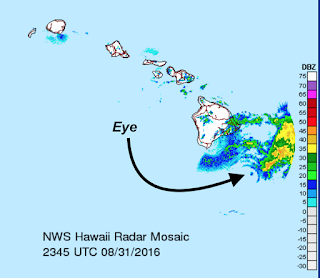
Here is the radar depiction of the eye as it passes the Island of Hawaii. The storm is weakening as it moves to the west. It should be affecting Hawaii now with conditions improving on the island late tonight.

The Scoop on Tropical Storm Hermine

Image
First, AccuWeather has extensive coverage here . They keep updating it so it is the "go to" site throughout the storm. That said, here is a rundown of the intensifying tropical storm. AccuWeather's path forecast looks like this. Windy is putting it mildly. It is difficult to depict the extent of the winds and their speeds. If I am right about intensity,  the deep red is areas where gusts of 75 mph or so could occur. Please, consider this just an approximation. Here is a worst-case scenario for storm surge, which is defined as the amount of water above normal tides. It does not include waves. Tornadoes are quite possible in northern Florida tomorrow. I expect tornado watches will be issued.  Here is the amount of rain forecast for the Southeast the next 3 1/2 days. Flooding is possible. I'll do another summary tomorrow morning. If you live in the affected areas, please take appropriate precautions now. 

Update on Tropical Weather

...I'll have one up on the blog early this evening.

Tropical Update: Hurricane for Hawaii; Storm for Florida

Image
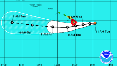
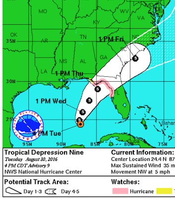
The hurricane watch and tropical storm warnings are in effect for a larger area of the Florida Gulf coast. The forecast for Hurricane Madeline has not changed. Hurricane preparations should be completed.

Hurricane WARNING Island of Hawaii

Image
The red outline is the Island of Hawaii which has a hurricane warning  in effect. Winds could gust to 90 mph! Power failures are likely along with flash flooding. The yellow is a tropical storm watch  for the Islands of Maui, Molokai and Lanai.

Hurricane Watch For Part of Florida

Image
Even though it is still not a tropical storm, the National Weather Service has issued a hurricane watch for the Florida coastal big bend. The storm is forecast to hit Thursday afternoon or evening. If the hurricane develops, this is what the storm surge will look like. In some spots (orange), it will be six feet above tide. click to enlarge Flooding rains are also forecast to develop. I'll periodically update the blog as this situation develops.

Flooding Rains for Florida

Image
As the tropical system begins to turn north then NNE, flooding rains are likely in Florida.

The Poor Quality of Media Reporting About Weather

Image
Jason Samenow has a timely article here . I agree with Dr. Roger Pielke, Sr.'s addition: The quality of climate reporting is terrible in many newspapers and on network news.

The Great TV Weather Debate

Image
Boston has, traditionally, been a television market with excellent meteorologists and excellent coverage weather coverage. Over the weekend, the Boston Globe  had a debate about the future of TV weather. The case against TV weather is here . The case in favor of TV weather is here . As both a meteorologist and a former television meteorologist  Me doing the weather on WKY TV (now KFOR) in Oklahoma City in the prehistoric era. This was before character generators and we had to label the forecasts and maps by hand! I believe there will be a  need  for television meteorologists for the foreseeable future if the meteorologists and their stations adapt. How? Authoritative coverage of major weather events is absolutely essential. I am still shocked when I travel and see TV weathercasters who obviously cannot properly interpret weather radar.  The coverage must be provided as the weather dictates, not "details at 11"! TV stations need to provide what their viewers

A Great Book About How Storm Warnings Save Lives

Image
As hurricanes threaten....

Three Tropical Systems Threatening the U.S.A.

Image
One is headed for the Outer Banks of North Carolina and is not expected to intensity beyond tropical storm strength. However, boaters getting a start on the Labor Day weekend should be aware of the system the middle of this week. Here is the system we've been watching for several days. It is finally a tropical depression. I am reasonably confident it will turn into a tropical storm and, maybe, a hurricane. Next, we head into the Pacific. Tropical Storm Madeline is threatening Hawaii. So, there is plenty to keep track of in the tropics. AccuWeather is tracking it all.

Nothing To Worry About

Image
After briefly rallying yesterday, the tropical system between Florida and Cuba is still looking weak and disorganized. If things change, I'll let you know.

Sunday Fun: Parents of Teenagers? Consider This

Image
Over their objections at the time, I made all three of our children work at McD's (we knew the owner of a chain of Wichita-area restaurants). Over time, each of them have come to agree with the sentiments expressed by the college student in this video.

Tropical System Looking Slightly Healthier

Image
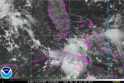
The weather system southeast of Miami is looking a little better organized this morning and it is moving into an area with both warm water and less wind shear. So, it may strengthen a bit, especially when it moves past Florida and into the Gulf of Mexico. So, stay tuned.

"Home on the Range" -- The Movie

The state song of Kansas has quite a colorful history. It is being shot in Wichita or a made for TV movie. The story is here .

Little Change in Florida Advice

The disorganized weather system continues to head toward south Florida with no signs of better organization from what I can see. I continue to suggest that people with special needs (see below) get special attention as the storm approaches. Otherwise, I don't believe the rest of the population in south Florida needs to take special precautions. The storm may go into the Gulf and may intensify there, but there is time to wait and see for that region.

Mobilization Like WWII's to Fight...Global Warming??

Details of a terrible idea, here .

No News on Tropical System

I really don't have anything to add with respect to the system in the tropics. Yes, I still think it will affect Florida south of I-4. Whether it is stronger than gusty winds and very heavy (with flooding quite possible) rains is still questionable.

Mocking "The Consensus"

I often mock the "consensus" on catastrophic global warming because "consensus" has no place in science. Here are some great examples . Science is about what can be objectively proven. It is not decided by polls of scientists.

The Mess in the Atlantic

Image
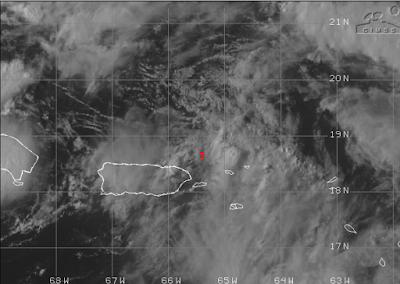
The red "I", courtesy of the University of Wisconsin, is the meteorological center of the messy system in the Atlantic that has (relatively) strong winds (gusts to 60 mph) but no real organization. So, should you change your plans if you live in Florida or are planning to visit? Go ahead and get frustrated with meteorologists: I don't blame you. The problem is that our tropical storm and hurricane forecasting techniques are built around weather systems that have a well-defined center which this mess certainly does not. The problem is that the system is headed in the general direction of the Bahamas and then the United States. Water temperatures are extremely high and the system -- might -- strengthen rapidly when it gets over that water. Or, it might not do anything just as it has refused to organize the last couple of days. I'd like to be able to tell you we'll have a lot better idea tomorrow but the weather system did not get better organized today as I

A Superb, To-The-Point Article About Who the REAL Scientists Are

Please read the entire article, here . In the meantime here is what you need to now to tell the difference between a real scientist and an advocate masquerading as a scientist: A  good  scientist would rather live with an unpleasant truth than embrace a comfortable lie. Good  scientists do not  suppress  debate, they  insist  on it. Good  scientists with opposing views attack one another’s  arguments , but  not  each other. A  good  scientist knows that skepticism, whether or not it is the sign of a heretic, is actually essential to the practice of good science. A  good  scientist would rather be right than be President. A  good  scientist knows that 2 + 2 = 4, always has, and always will, no matter who occupies the positions of power in politics or culture. A  good  scientist knows that science is  not a democracy , that scientific truth is  not  determined by a show of hands, and that  consensus  and  authority  are there to be  challenged ,  not  to be accepted without que

Tropical Threat?

Image
If I were in Florida's Penninsula, I would now start paying attention to the developing tropical system. I would not do  anything yet with one exception: If you have a special needs person (i.e., must have an operable breathing device or special prescription drugs) living with you or under your care, I would be thinking about purchasing a generator, getting prescriptions renewed, etc.  At this moment, a hurricane hunter aircraft is on the way to the low pressure area in the Atlantic and will report back. I suspect by early evening we'll have a much better idea as to the future of the storm.  I'll try to provide no-hype/no-panic information alongside my colleagues at AccuWeather . 

100-Year 'Sustainable' School Closed After Six Years

Image
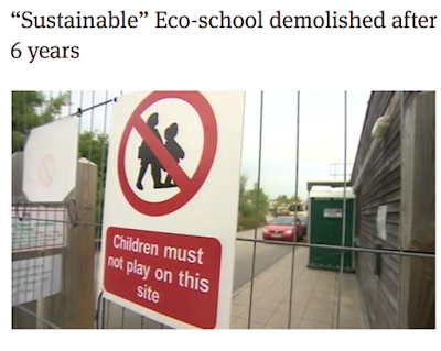
There may  be a time in the future when 'sustainable' is cost-effective and green energy makes sense but here is another example that day is not yet here.  Another $20,000,000 (in U.S. dollars) down the drain to the sustainability gods. When are we going to stop this idiotic, and expensive, waste of taxpayer dollars across the Western world? Think about how many schools this money would buy in Africa??

Bill Nye the Mis-Information Guy

Image
Will he ever get one of these interviews right? Don't hold your breath. The man knows nothing about meteorology or climate. Nothing. Nye calls the Louisiana rainstorms "hard to forecast" when they were very well forecast. This blog started talking about it six days  before the storm began! Nye blames climate change for the flood. Flooding is getting less bad in recent decades!!! He then calls the CNN meteorologists (even though no one asked him), "climate change denier meteorologists." Unlike CNN's meteorologists, Nye has no, zero education in meteorology or climate. So, here is what is occurring in the United States' climate in recent decades: Tornadoes? Down. Hurricanes? Way down. Floods? Much less damaging (see above).  Rainfall? Up in the Farm Belt. Growing season? Longer. If this is what global warming is going to do for us, what's not to like?! Every time CBS or CNN has Nye on the air, it is a factual debacle. ADDITION

My Advice to Those Along the Gulf and Florida-Georgia Coasts

Will there be a tropical storm? Don't know. Will there be a hurricane? Don't know. If there is a hurricane, where will it hit? Again, I don't know. That said, it I were a governmental or corporate emergency manager in in coastal Florida, Georgia or the Gulf coast to the east of Texas, I would be dusting off the hurricane emergency procedures and seeing if they need to be updated. It has been nearly 11 years since a major hurricane hit the United States and many things have changed since them. Just in case the streak should end, you want to take this time to take a look at procedures and make sure they are both current and appropriate.  To the public at large ? Nothing needs to be done at this point. 

Significant Tornado Risk: Kansas and Oklahoma

Image
There is a significant tornado risk in southern Kansas and north central Oklahoma through this evening. Please keep up on local weather information.

Let the Hype Begin!!

As previously mentioned, the more active state of the tropics the past week has led to almost silly speculation as to when/if a hurricane might hit the United States. Now that we are 5-6 days (at the earliest) out from a potential  landfall, we have really seen the hype ramp up. But, here is the problem: The hurricane hunter plane that investigated the system a few hours ago showed it has not  strengthened or organized. So, there is no need for undue concern. If things look like they may become serious, AccuWeather and I will keep you informed.

A 5-Star Book

Image
For more, go here .

Good Advice From Our Friends at Union Pacific

Image

"I'll Believe Global Warming is the Crisis When the People Telling Me It's a Crisis Start Acting Like It's a Crisis"*

Image
Good to know that Hillary Clinton is taking firm action against unnecessary greenhouse gas emissions. * Dr. Glenn Reynolds, University of Tennessee

Sunday Fun: Squirrel Steals Go-Pro. Takes Us on Tour of Trees

Image
This is surprisingly beautiful. Enjoy on this Sunday.

Flood Danger in Texas Tonight

Image
If you are in one of the areas where heavy rain is forecast, please  keep up on the weather and, whatever you do, turn around, don't drown!

The Frustration of Being a Meteorologist

Image
Yesterday's heavy rain.  Last night, I was tweeting and posting on Facebook pertaining to the extremely rapid developing flash flood southeast of Wichita. Here is one of them. And, this morning, we are learning of numerous water rescues and at least one fatality in exactly the area outlined above. Not only are people putting themselves in danger, they are risking the lives of the first responders. Of course, I don't expect everyone to be a friend on Facebook or a Twitter follower. of mine. My frustration is that meteorologists (especially AccuWeather Enterprise Solutions which did a superb job for its clients) have the information needed in time to save lives but two things seem to be preventing it: The information isn't getting to those that need it and, or, People are driving into flooded areas anyway. The Wichita area is not the only region with flash flooding this week. The Dallas Metroplex has seen heavy rain as have some other areas in Texas along with

I'm Starting to Get Annoyed With Meteorologists...

…who are posting some terribly irresponsible forecasts relating to hurricanes. There no, zero, chance of a hurricane striking the mainland United States in the next six days. After that, who knows? We do not have the ability to forecast hurricanes ten or more days into the future.

Widespread Rains the Next Seven Days

Image
Every state except Washington and Oregon will have significant precipitation during the next seven days with some heavy rains from Texas to Nebraska. Another area of heavy rain will be northern Wisconsin.

What Television Meteorologists Have to Put Up With

There was a damaging tornado or tornadoes in Indiana earlier this week. The ABC affiliate provided an important warning service to its viewers. Anthony Watts picks up the story (and, thanks, Anthony for mentioning Warnings ).

Tornado Risk Today

Image
There is a small area on the South Dakota-Minnesota border with a significant tornado risk today. Please keep up on the weather in this region.

A Headline You Will Never See

Image
"So Far, Conservative Scientists Have Been Correct About Embryonic Stem Cells" Here is a headline from last week's MIT's Technology Review, The article goes on to state, "No field of biotechnology has...delivered less...than embryonic stem cells." Turn the clock back 15 years. Conservatives were stating that it was immoral to create embryos to for the purpose of harvesting embryonic stem cells. Scientists also stated that, while adult  stem cells had tremendous potential, embryonic stem cell research was highly speculative. Here is a partial list of diseases and conditions that can be assisted with adult stem cell treatment. Cancers: Brain Cancer  Retinoblastoma  Ovarian Cancer  Skin Cancer: Merkel Cell Carcinoma  Testicular Cancer  Tumors abdominal organs Lymphoma  Non-Hodgkin's lymphoma  Hodgkin's Lymphoma  Acute Lymphoblastic Leukemia  Acute Myelogenous Leukemia  Chronic Myelogenous Leukemia  Juvenile Myelomonocytic Leuk

Tornado Risk in the Northeast

Image
If you live in the brown (5%) area, please keep up on the weather today. There is a risk of a few tornadoes this afternoon and evening. This will also cause serious airline delays throughout the region. If you can take an earlier flight today, you may wish to do so.

Remember When Global Warming Was Going to Destroy Crops?

Image
Just go back a few years and you read this all over the MSM... That is Dr. James Hansen, who since 1988 , has been telling us, over and over and over, that terrible consequences are just around the corner ("scorching crops in the Midwest") due to global warming. Now, the problem isn't "scorching" but surplus. The reference to "sinking" refers to lower prices per bushel of corn and other grains because so much has been grown this year. I am hoping farmers will be able to store the surplus as increasing (but still a minority) numbers of scientists are forecasting global cooling the next few years . If so, the cooler temperatures would likely suppress grain production due to the shorter growing seasons 

Final Flood Forecast

Image
This has turned into a news story and the rains are lessening in the area affected. Here is a final update for everyone. The map shows the status of various rivers (the legend is not covering up any rivers in flood or forecast to flood). Total rainfall. We've seen (below) the extraordinary rain in Louisiana. Here is a map of the Midwest rainfall as of 7am. Yes, that is a spot of more than 14" in southeast Missouri. The forecast rains are much less now. Here is the two-day rainfall amount forecast. So, with the rain moving out, this will be the last forecast pertaining to the flood as it now transitions into a news story.

A Gripping Story...

Image
...about a horrific storm. The Joplin tornado killed 161 because the warning system failed the community on a warm, humid Sunday afternoon in May, 2011. The softcover version of the book sold out quickly after it was released. However, the book is available for Kindle , Nook or just to read on your computer as shown below (the Kindle Cloud reader is free) for the very reasonable price of $2.99.  You'll find Sirens  to be a gripping book about a terrible storm, along with tornado safety advice for home, school and work. 

8pm Sunday Flooding Update

Image
The historic flooding in Louisiana is finally being covered by some of the national media. Per their press release this morning, FEMA is even sending a truck, which is nice of them. They are also gathering supplies, "in case they are needed." The town of Watson, Louisiana has received an incredible 31.39 inches of rain. Adjusting our attention farther north, here is the total rainfall, so far, in the middle Mississippi and lower Ohio Valleys. Some areas have already received more than six inches. Below is the forecast rainfall for the next five days. Most will fall in the next three. Serious flooding will result in these areas. Please keep up on the latest weather forecasts!

Please, Please, Please

Image

Storm Total Rainfall: 20+ Inches!

Image
Here is the storm total rainfall in the south central United States. The white areas have received more than twenty inches. There are isolated areas that likely received 30 inches.