Tuesday, April 30, 2013
Did Weather Play a Role in the 747 Crash in Afghanistan?
Yesterday morning, a 747 cargo plane crashed on takeoff from Bagram Air Force Base, killing the seven people on board. There is quite a bit of speculation on the internet that weather was involved. While the speculation may be warranted, it is far too soon to know the cause of the crash.
Because of the interest, let's take a look at a few things we do know. The map below shows the location of the base north of Kabul.
The European weather satellite image below, from 1.5 hours after the crash, shows an area of extensive clouds (arrow) with showers and thunderstorms that includes the area around Bagram.
The Aviation Herald has the aviation weather observations (known as "Metars") from Baghram. They reveal there was lightning visible, gusty winds, and shifting winds in the area. The base weather observer was estimating rather than measuring the wind. The array of weather instruments to help detect wind shear we enjoy in the U.S. doesn't exist.
Let me hasten to add that weather may have little or nothing to do with the crash. There are reports cargo may have shifted. That said, we know that wind shear on take off can cause planes to stall aerodynamically and fall from the sky. That occurred in the case of Continental Airlines Flight 426 from Denver to Wichita August 7, 1975. In that case, the thunderstorms were near rather than at the airport and the plane fell from the sky shortly after take off. Fortunately, there were no fatalities.
In the U.S., wind shear-related airline accidents have all but been eliminated. The last was in July of 1994. Tragically, they continue in other parts of the world. I'll report on the progress of this investigation to learn the role, if any, of weather.
Congratulations to the National Weather Service
It has completed its upgrade of its radar network to dual polarization.
Among the many uses of dual polarization radar is confirming that a tornado is on the ground, confirming that hail is present and the type of winter precipitation.
Another important step in weather science.
Among the many uses of dual polarization radar is confirming that a tornado is on the ground, confirming that hail is present and the type of winter precipitation.
Another important step in weather science.
Very Heavy Rain Forecast in Corn Belt
Five inches of rain is forecast over the next five days in western Iowa. Corn planting has already been delayed in several areas and this will only make the situation worse. However, the rain in central Nebraska, Kansas, and northern Oklahoma will be welcome.
Dog Endangered By Anti-Cruelty Group
While I usually blog about weather safety, safety of all kinds interests me. I don't want people -- or animals -- hurt unnecessarily.
The website Care2 chose to use a dog in the middle of a railroad track to discuss a story about a new law making animal cruelty a felony. I believe the above photo qualifies. I hope the local prosecutor is reading.
Four hundred people each year are killed, 500 injured trespassing on train tracks.
Railroad tracks are for trains: They are not for people or pets!
Monday, April 29, 2013
NOOooooooo!!!!
Oh, the Humanity!
700 Club |
Drought and Rainfall Update
The drought continues to be whittled away from east to west.
Meanwhile, some pockets of drought have developed along the Atlantic coast.
Here is the 5-day rainfall (and, yes, moisture content in snow) amount forecast:
Meanwhile, some pockets of drought have developed along the Atlantic coast.
Here is the 5-day rainfall (and, yes, moisture content in snow) amount forecast:
Really, Really Good News
When held in constant dollars, the U.S. economy has never been more energy-efficient. Details here. H/t James Tunkey.
Sunday, April 28, 2013
Winter Wheat Update
Here is the precipitation for the last 30 days:
Below is the departure from normal for the last 30 days (scale at right):
The Kansas Wheat Tour is this week and should give us some answers about the condition of the crop which is about ten days behind schedule.
Below is the departure from normal for the last 30 days (scale at right):
The Kansas Wheat Tour is this week and should give us some answers about the condition of the crop which is about ten days behind schedule.
Climate Forecasts Versus Reality
In an interesting story from Canada (h/t Anthony Watts), Dr. James Hansen, a global warming activist stated,
He said many governments, not just Canada's, are denying what science is telling them and ignoring the long-term climate change projections.
Okay, let's take a look at Dr. Hansen's own projection using Dr. Hansen's own temperature (a data set known as GISS) data:
The blue triangles are Dr. Hansen's forecast of world land+ocean temperatures. The black are the actual temperatures. Note that the real world is far cooler (0.5°C which is a lot) than it was predicted to be by Dr. Hansen.
Here is a more recent set of forecasts made by 31 climate models (the thin colored lines) and the satellite temperature observations (black circles) and the ground-based land+ocean temperatures (a/k/a HADCRUT, the metric you consistently see on this blog and in my presentations):
Again, far too warm. You can see the above graph and more model comparisons (all of which demonstrate the climate forecasts are too warm) at Dr. Judy Curry's blog here.
"Ignoring the long-term climate change predictions." Given the track record of these forecasts, I'd say people are acting rationally.
Sunday Funny II: Global Warming Chic
Sunday Funny: Homer Meets 500mb Chart
Below is a posting about potential heavy rains developing late this week and early to middle the week of the 7th in the central and eastern U.S. This will be caused by an usual "closed low" forecast to develop.
Posted yesterday by Brian Etherton (h/t John Knox).
Saturday, April 27, 2013
Last Two Updates for the Night
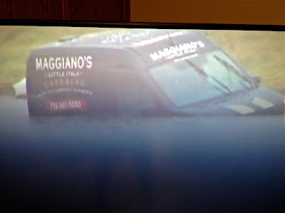
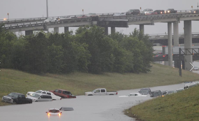
In Houston, serious flooding continues (see posting below):
Here is the radar estimate of how much rain has fallen this afternoon and evening:
And, one tornado and several severe thunderstorm warnings (yellow) continue in the Mississippi Valley where a tornado watch continues. Radar from 7:41pm.
This will be the last update of the evening.
![]() |
Texas Storm Chasers Via Facebook |
And, one tornado and several severe thunderstorm warnings (yellow) continue in the Mississippi Valley where a tornado watch continues. Radar from 7:41pm.
This will be the last update of the evening.
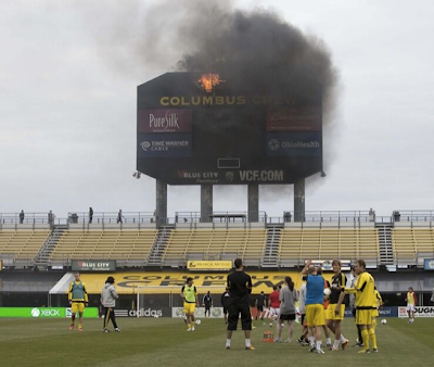
Don't Ya Hate it When the Scoreboard Catches Fire??
Photo a few minutes ago via my friend Betsy Kling and Twitter. It is of the Columbus Crew warming up before a game this evening. Even though the sky is cloudy, I checked and the cause is not lightning.
Rainfall The Next Eight Days
Yes, that is five inches in west central Iowa with three inches south into the Flint Hills of Kansas. If anything, I think the axis of heaviest rains are a little far to the east. The weather system that is developing may produce moderate to heavy rains over a good part of the central and northern Plains. I'll be keeping an eye on it for you.
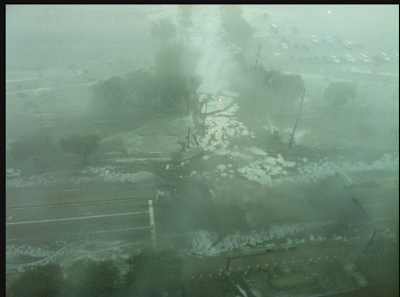
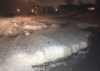
Hail Rivers in Houston
Via Johnny Kelly and Twitter, rivers of hail in Houston taken from Reliant Stadium. Here is what the radar looks like:
The green polygon is a flash flood warning.
Addition: From the Willowbend area of West Houston via Eric Berger on Twitter.
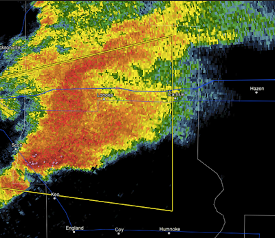
Severe Thunderstorm Warning for Little Rock
Radar at 4:58pm. People around Keo should keep a close eye on the storm. Last update on this storm.
Radar at 4:34pm:
We have a splitting supercell. The northern cell will produce large hail. The southern cell will produce large hail with the better chance of damaging winds. It should be especially monitored for a possible tornado.
ORIGINAL POSTING:
Entire Little Rock Metro is included. Radar at 5:20pm below:
Hail large than 1" in diameter and winds in excess of 60 mph are possible with this storm in the yellow polygon. Bring your car and lawn furniture indoors and gather up the children. Keep in mind a tornado watch is in effect. Be prepared to move to shelter.
Tornado Watch Issued
Radar at 3:49pm shows thunderstorms starting to develop over the region.
And, farther west over central Arkansas where the storms (3:50pm) are starting to take on supercellular characteristics:
Consequently, a tornado watch has been issued for the region:
Please monitor the weather in this region.
And, farther west over central Arkansas where the storms (3:50pm) are starting to take on supercellular characteristics:
Consequently, a tornado watch has been issued for the region:
Please monitor the weather in this region.
James Spann's Second Anniversary Comments
*The false alarm ratio for tornado warnings issued by the National Weather Service in Birmingham has been cut in half since April 2011. This will reduce the “cry wolf” syndrome, and make people take warnings seriously. My friends at the NWS here have done an remarkable job in making this happen by going back to basic science.
Congratulations to the NWS in Birmingham. Well done. In Warnings: The True Story of How Science Tamed the Weather I state that false alarms is the biggest challenge in meteorology these days.
The information about the false alarm rate is from James Spann's wonderful essay on the two-year anniversary of the tornado outbreak (h/t Elaine Spencer) across the South. He also says,
I certainly empathize with this James' thinking. I've often said that the Ruskin Heights tornado set the stage for my entire life (including meeting my future spouse and my career in meteorology).
Go read James' entire essay (dark green link above). Most meteorologists get started because of a storm or unusual event in childhood.
James laments the "large" death toll that day. There was nothing meteorologists could do about the fact that hundreds of thousands could not receive their warnings. Or, that people didn't have basements. Or, that a large percent of the population in his viewing area live in mobile homes.
As I have said many times: James and the other meteorologists that day saved many, many lives.
Congratulations to the NWS in Birmingham. Well done. In Warnings: The True Story of How Science Tamed the Weather I state that false alarms is the biggest challenge in meteorology these days.
The information about the false alarm rate is from James Spann's wonderful essay on the two-year anniversary of the tornado outbreak (h/t Elaine Spencer) across the South. He also says,
It is my belief we are born to accomplish certain goals. To be at specific places at a moment in time. Whether your life lasts six hours, or ninety nine years. We all have a defining moment; all of our life experiences, lessons, and knowledge take us to that moment. If we are ready or not.
For me it sure seems like I was meant to be on the big green wall April 27, 2011. My friend Jason Simpson was meant to be in that studio with me. There is no manual or guide on covering 62 tornadoes in one day; you just have to do the best you can.
I certainly empathize with this James' thinking. I've often said that the Ruskin Heights tornado set the stage for my entire life (including meeting my future spouse and my career in meteorology).
Go read James' entire essay (dark green link above). Most meteorologists get started because of a storm or unusual event in childhood.
James laments the "large" death toll that day. There was nothing meteorologists could do about the fact that hundreds of thousands could not receive their warnings. Or, that people didn't have basements. Or, that a large percent of the population in his viewing area live in mobile homes.
As I have said many times: James and the other meteorologists that day saved many, many lives.
Today's Tornado Threat
There is a small, but significant, risk of a tornado over southwest Tennessee including Memphis.
And, after last night's pounding in central Oklahoma, very large (hatched) hail of more than two inches in Texas and a good chance (30%) of one inch or larger hail in the mid-Mississippi Valley.
Second Anniversary of April 27, 2011 Record Tornado Outbreak
A record tornado outbreak occurred two years ago today. Three hundred sixteen died in the South.
The death toll was high in spite of excellent forecasts and warnings for two reasons: The tornadoes were unusually strong and hit populated areas (in a region with relatively few basements) and line of thunderstorms occurred in the morning that knocked out power for hundreds of thousands before the violent tornadoes arrived in the afternoon. Without power, tornado sirens, NOAA weather radio and commercial radio stations were off the air (in places). And, even if the local TV station was on the air, if a person in the path didn't have power, there was no way to watch TV or monitor the internet.
The morning storms were so strong, they misled some people into thinking it was the tornado event broadcast meteorologists had been forecasting the night before. With the lack of power, that confusion made effective warnings even more challenging.
Here is an example of the forecast of the tornadoes broadcast the night before and during the tornado outbreak. It is worth watching the entire video as an example of television meteorology at its best.
The dramatic video below, taken in Tuscaloosa, illustrates the problem of warning people when there is no power. Even though cars have their headlights on, note that none of the buildings have lights on. There is no tornado siren to be heard.
Some good is coming from this day from research being conducted in its wake.
Congratulations for all of the excellent work by the National Weather Service, broadcast meteorologists, emergency management, and first responders. All saved lives that horrible day.
Two Day Rainfall and Outlook for More
Here at the Smith House, we received 0.37 inches (northeast Wichita) over the last two days. Here is a map of the rainfall over the same period.
Here is the forecast for additional rain (and, yes, in some cases snow) over the next seven days.
Friday, April 26, 2013
Video of the Wichita-Andover Tornado I Have Never Seen Before
I have never seen this video before. I do not know the photographer. You can hear the coverage of KFDI Radio at first, then the excellent coverage of meteorologist Merril Teller of KWCH TV. Of course, this was 22 years ago this evening.
I was just getting home about this time after simultaneously tracking four tornadoes. Was absolutely exhausted after being continuously on the air then doing news coverage of the disaster for media as far away as Australia.
Hail in Edmond, Oklahoma, This Evening
![]() |
Via Twitter |
The more southwestern storm caused "significant" damage due to wind and hail in the town of Anadarko, Oklahoma.
Severe thunderstorm watch for southeast and south central Oklahoma until 4am CDT.
Very Large Hail and Damaging Winds Headed Toward OKC
UPDATE: RADAR at 8:39pm.
Confirmed 1.3" inch hail but it looks larger northwest of The Village.
Be prepared for gusts to 60-70 mph and hail up to 2" in the yellow polygon.
Hail video from Edmond here.
UPDATE: 8:22pm:
Radar at 8:19 shows the likelihood of 1.5 to 2.5" hail along with wind gusts of 70 mph
or higher between Piedmont and El Reno. This should reach Woodward Park,
Warr Acres, Nichols Hills and The Village shortly.
ORIGINAL POSTING:
Hail 1-2" in diameter and wind gusts above 60 mph could be quite destructive. Put your car in the garage, put away lawn furniture (especially trampolines) and bring the kids indoors if they aren't already.
What I Was Doing 22 Years Ago at This Time
A number of people have posted on Facebook and elsewhere what they were doing as the Wichita-Andover tornado of April 26, 1991, was moving across the region. Well, this is what I was doing:
Since there are many photos of the tornado itself online, here are a couple of photos of the damage it caused:
And,
That tornado killed 17 and the tornado to the south in the series (four tornadic supercells aligned north-south) killed two. Other fatalities occurred in Oklahoma with tornadoes from the southernmost supercell.
This tornado was before the days of Doppler radar but we still did an outstanding job of effectively warning. The U.S. Centers for Disease Control estimated that 75 people would have died (rather than 17) had the warnings not been as good.
Now, an interesting fact: The CDC concluded that at least 15 of the 17 people knew the tornado was coming in time to save their lives but failed to act in time. Since 1991, warnings have become even more accurate. It looks like tornado season be more active in May: Please take tornado warnings seriously and act accordingly when you are included in one.
Global Aviation Community
As you know, Mike is an speaker, author and innovator who presents frequently to members of the aviation, agriculture, banking, business and insurance communities. As the nation's leading expert in extreme weather, Mike can speak to your group with a custom presentation that will address the specific needs of your conference attendees.
Mike spoke recently at the Bombardier Safety Standdown last fall in Wichita, Kansas and as a result, has been fully featured across all platforms utilized for Safety Standdown; their website at www.safetystanddown.com - Experts page, Knowledge Center (post and video), on LinkedIn in the 'Safety Standdown Worldwide' group, as well as being shared across many other aviation groups, and on their Facebook page, "Bombardier Safety Standdown'.
To learn more about the global aviation community, and Mike's contribution in the area of weather expertise, please visit www.safetystanddown.com and contact me at mindy@mikesmithenterprises.com for more information or a fee schedule. We would love to work with you on your next conference or event!
"Warnings" eBook
There are sixteen additional color photos in the ebook that we could not fit into the hardcover version. And, you do not need a Kindle or Nook to read the ebook. You can read it, free, with the Amazon Cloud Reader.
For Wichita-Area Readers
Fifteen hundredths of an inch of rain at the Smith House with the overnight thunderstorms. Another area of thunderstorms approaching from the southwest.
Subscribe to:
Posts (Atom)