Posts

Showing posts from November, 2018

Tornado Watch Until 5am

Image
Please make sure you have a source for storm warnings during the night. Note: Last posting of the night.

Second Tornado Watch and Winter Storm Warning

Image
Here is the second tornado watch of the day which is in effect until 2am Saturday. There is a real risk of tornadoes during the night...one or two of which could be strong. I urge you to make sure you have at least two sources for tornado warnings; at least one of which can awaken you. Also...a winter storm warning (pink) continues in parts of the central and northern Great Plains. More than a foot of snow is forecast. Gray equals dense fog advisories. In some places, visibilities are 100 yards or less.

Tornado Watch: Oklahoma and Texas

Image
A tornado watch has been issued for much of Oklahoma and most of north Texas, including most of the DFW Metroplex. Please note, this is farther west than earlier forecasts. The tornado watch is in effect until midnight. In addition to tornadoes, very large hail is possible. Please make sure your friends and relatives are aware of this risk and have at least two sources for possible warnings.

UPDATE: Serious Out-Of-Season Tornado Risk Later Today and Tonight

Image
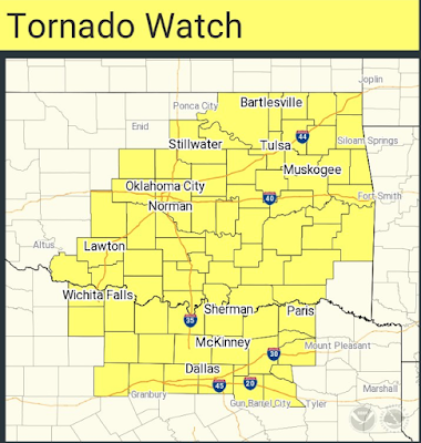
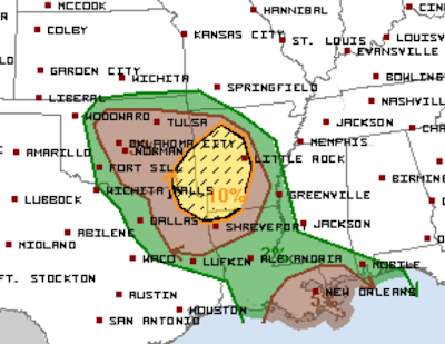
The NWS SPC has revised its tornado risk forecast. The brown (5%) area is significant risk of tornadoes, beginning around 3pm. It now includes Oklahoma City, Tulsa, east parts of the Metroplex, Shreveport, Tyler, Baton Rouge, Gulfport and New Orleans. The highest risk should start after 3pm and continue into tonight. The yellow (10%) risk area is the enhanced  risk of tornadoes. It includes Shreveport, Little Rock, Ft. Smith, Mena and Idabell. The hatched area is where strong tornadoes are forecast to occur. Because outbreaks of tornadoes are infrequent after Thanksgiving, there is the potential that people will be caught unaware. So, I recommend you notify any friends or relatives in the affected areas. I will not be available to provide any kind of routine updates. So, for your safety, I recommend monitoring reliable local sources of storm warnings. The AccuWeather app is outstanding as is Weathercall. 

Serious Out-Of-Season Tornado Risk Later Today and Tonight

Image
The area in brown is a significant risk of tornadoes. It includes New Orleans, Shreveport, the east part of the DFW Metroplex, Muskogee and Little Rock this afternoon and tonight. The area in yellow is an enhanced risk of tornadoes. The hatching means there is a risk of strong tornadoes, including during the night. I no longer live-blog tornadoes but I will try to update again around midday. In the meantime, please make sure friends and relatives in this area know of the risk and are prepared.

The Expensive Folly of Wind and Solar Energy

Image
While I still believe that solar energy can make a positive contribution to our energy supply if the price continues to drop and  weather forecasts of cloud cover continue to improve  and  the cost of electrical storage goes way down. I otherwise agree with this report . I fear the Great Plains, in a decade, will be littered with rusting wind towers as this folly becomes more widely recognized and tax policy recognizes that fact.

Tornado Risk Friday

Image
Heads up for an out-of-season risk of tornadoes and severe thunderstorms tomorrow and tomorrow night. On this chart, 15% (yellow) is the significant threshold for tornado and severe thunderstorms (large hail and/or damaging winds. Red is 30%, which is an enhance risk. The hatching indicates the potential for giant hail from the DFW Metroplex north to Ardmore, Oklahoma.

Why I Use DuckDuckGo As My Search Engine....

Image
...rather than Google. I don't want to support Google. The latest incarnation of their famous "Don't Be Evil" motto seems to have eliminated the first word. The current example (of many) is their cooperation with China to build a censoring search engine that eliminates results the Communist government finds, er, "inconvenient." Here is an example from Twitter earlier today (I just confirmed Google's definition is still the same). I have set my default search engine to DuckDuckGo with Bing as my second choice. It works just fine. Only rarely do I use Google. ADDITION: Dossiers on students . More of Google's "Be Evil" philosophy.

Freeze-Dried Vaccine May Help Rid World of Polio

This is potentially wonderful news . Trying to haul chilled vaccine into the darkest corners of the world is a monumental task. As a member, I am extremely proud of Rotary International's work to rid the world of polio.

An Amazing, Almost Inconceivable Image

Image

No End in Sight to the Catholic Clerical Abuse Scandal

Image
As a Catholic, the whole thing is sickening beyond belief. Unfortunately, I agree with Dr. Steven Bainbridge, a Catholic and the William D. Warren Professor of Law at UCLA. I couldn't have said it better.

Climate = Long Term Weather

Image
This topic has received a lot of attention since the release of the overwrought climate report Friday afternoon. Dr. Marshall Shepherd is one of the leading champions of catastrophic global warming and a former President of the American Meteorological Society. Marshall is absolutely correct. That is why a single hurricane, a single wildfire in California or a flood in Texas has little to nothing to do with climate.  Climate is simply the long term weather and nothing more. 

Speaking of the Blizzard

Image
click to enlarge And...

Review: The Quality of Warnings of the Blizzard Just-Passed

Image
This was the view in Kansas City about 5pm yesterday. At the Same Time at Chicago's O'Hare International CBS2 The FAA listed average delays of 339 minutes = more than 5.5 hours.  And, those delays existed even though hundreds of flights were proactively cancelled. Some responded perfectly. I received this tweet as I was writing this piece. Wonderful and heart-warming!! Maybe more responded than it first appears. But, given the news reports, the question is, why were so many trapped in cars, injured in winter weather-related traffic accidents, or stuck at airports when they could have taken advantage of the waivers offered by the airlines to rebook their flights? I don't know whether, People were not aware of the blizzard and winter storm warnings. People were aware but were not motivated to change their flights/travel plans (leave early). The warnings were not believed.  We know there is some anecdotal evidence of the third. One TV meteorolo

1:55pm Blizzard Update

Image
The purple hatching is where heavy snow is forecast to occur with the highest probability in the dotted burnt orange area (via NWS SPC). This includes the Chicago airports. Attached is the radar as of 1:45pm. Snow is ending in Wichita. I-70 still closed from Topeka to WaKeeney, Kansas. I-35 just closed from Emporia to Beto Jct. (US 75) in Kansas.  This will be the last post on the blizzard because I feel that there is no more warning to do for it.

Noon Sunday: Blizzard Update

Image
The blizzard warning (orange) has been updated into Illinois. I'm not sure I understand how the counties were selected but this is it. It extends into the western and northern areas of Chicagoland. Here is the radar at 11:55am CST. At this moment, there are delays at the following airports: Boston San Francisco White Plains Kansas City Houston Miami I expect Chicago and Milwaukee to begin having problems after 2pm. ADDITION: 12:05pm. Thundersnow with very heavy rates of snow getting ready to move into Topeka.

Snapshot of the Blizzard at 11am

Image
Above is the radar at 11am. The heavier rates of snow correspond to the darker shades of blue. Below is from the NWS SPC and outlines the area where blizzard/winter storm conditions will be the worst for the next four hours. Gradually, the storm will be clearing from the west (eg, the snow has ended in Dodge City, KS) but roads continue hazardous. Please follow me on Twitter @usweatherexpert for additional information.

8:30a Sunday: Blizzard Update

Image
Interstate 70 is closed in central Kansas. There are semi's jackknifed and there are numerous  slide offs. The winds have gusted to 58 mph at Wichita's Eisenhower National Airport in the last few minutes. The blizzard warning (orange) has been further extended to the south and west. The winter storm warning (pink) has been expanded in Illinois and Wisconsin and includes both Chicago and Milwaukee. A high wind warning (gold) continues in southwest Kansas and southeast Colorado. Here is the radar as of 8:25am. Note the lightning bolt near Salina, Kansas. That is an indication of "thundersnow" which means snow rates can be as much as 4"/hr. With the winds that can mean severe blizzard conditions that are completely unsafe for driving. In the strongest possible terms, I urge you to postpone your trip if you have to drive through the blizzard/winter storm areas. So far, the only airline delays are at Denver (deicing) and Atlanta (low visibility). That will

Malaria: There is a Simple, Inexpensive, Effective Solution

Image
The entire article, which is quite good, is here . Think about it: 400,000 preventable deaths each year. It is immoral for this to continue. The inexpensive, effective solution is to bring back DDT. It is nearly harmless to humans (in the amounts recommended) and it is cheap: less than $1/household where it should be sprinkled around the baseboards. However, it is politically incorrect to resurrect DDT. It was wrongly condemned by Rachel Carson, the patron saint of the environmental movement, in her book, Silent Spring. So, millions continue to die in the name of political correctness. Such a tragedy.

Sunday Fun: Seems Rational to Me

Image

10pm Saturday Blizzard Warning Extended South

Image
The blizzard warning now includes Kansas City and Topeka, Kansas, as well as Kansas City and Warrensburg, Missouri. Interstate 70 is now included in a blizzard warning from Burlington, Colorado, across the entire length of Kansas to Lafayette, Missouri. Denver International Airport just reported a wind gust of 60 mph.

BULLETIN: 8:30 pm Saturday, Winter Storm Developing As Forecast

Image
Updated at 10pm.  The forecast snow amounts have been increased from last forecast.  This will be a severe blizzard with gusts above 40 mph which will cause drifting of the intense falling snow. There has already been a 20-car accident on I-70 in Colorado, closing the highway. Consider alternate plans rather than driving through this storm. Wind gust of 60 mph just reported at Denver International Airport. These winds will move into the Plains and will be part of the  blizzard.  If at all possible, move your flight to/through Chicago/Milwaukee tomorrow to as early in the morning, if possible.  Here is the regional radar as of 8:15pm   10pm  CDT. Blues are snow and darker blues = heavier rates of snowfall. Updated at 10pm CDT. The blizzard warning has been extended to the south. It now includes Kansas City and the entire length of Interstate 70 across Kansas.  Here is the forecast radar for 6am Sunday. Here is the forecast for 3pm Sunday.  The radar forecast

Bulletin: Blizzard Warning Expanded

Image
The blizzard warning has been extended from near Burlington, Colo. (on I-70), into northern Missouri and southwest and south central Iowa. A winter storm warning has been extended all the way ENE to Chicago and a winter storm watch is in effect for Milwaukee which may be upgraded tonight. Please factor this into your travel plans as the airports in Chicago and Milwaukee will be a mess when the snow begins (waivers have  been issued by the airlines) and it is unlikely you wish to drive through a blizzard. Finally, the gold-colored areas are high wind warnings.

Bulletin: BLIZZARD Warning Issued

Image
The orange area is a blizzard warning (which includes segments of I-80 and I-70). Frankly, I'm surprised the blizzard warning hasn't been extended into northeast Kansas, southeast Nebraska, and, especially, northern Missouri and southern Iowa. Please scroll down for more information.

Extraordinary Music+Weather Video

Image
I'm not usually a fan of music videos; not even during the MTV heyday. However, this video -- from storm chaser and musician Pecos Hank -- is extraordinary.  The weather and storm footage is Hank's as well as the song and the performance. Enjoy. H/T: Matt Sutkoski

Update on Major Winter Storm

Image
The airlines have issued waivers which allow people flying through the affected areas to reschedule their flights. I urge you to take advantage of them, especially if you are flying through Chicago or Milwaukee Sunday or Sunday night.  I also urge you to consider whether it is safe to drive through an area where heavy snow is occurring along with moderate to high winds.  Here is the overview: Pinks are winter storm warnings. Golds are high wind warnings (especially pertinent to trucks and large SUV's) Purples are winter weather advisories  Deep greens (near Chicago and into Michigan) are winter storm watches The storm that will affect the Great Plains and Midwest is now organizing over the Rockies as the 9:15am radar indicates. Here is the forecast radar for 6pm this evening. Greens are rain. Blues are snow with darker blues equal to heavier snow.  The forecast radar at 6am Sunday. The forecast radar at noon Sunday. The forecast radar at 9pm